Wednesday, April 24, 2024

Mostly Warm and Dry Pattern, a Little Rain Possible Next Week

FORECAST:

Thursday (High 78, Low 50): Partly to mostly sunny. Isolated showers are possible at night. 

Friday (High 81, Low 60): Partly to mostly sunny. Warm and breezy.

Saturday (High 81, Low 61): Mostly sunny. Warm.

EXTENDED OUTLOOK:

Sunday (High 82, Low 61): Mostly sunny. 

Monday (High 81, Low 62): Partly cloudy with a 20% chance of showers/thunderstorms.

Tuesday (High 80, Low 63): Partly to mostly cloudy with a 30% chance of showers/thunderstorms.

Wednesday (High 83, Low 58): Mostly sunny. 

PRONÓSTICO:

Jueves (Máxima 78, Mínima 50): Parcialmente a mayormente soleado. Por la noche son posibles chubascos aislados.

Viernes (Máxima 81, Mínima 60): Parcialmente a mayormente soleado. Cálido y ventoso.

Sábado (Máxima 81, Mínima 61): Mayormente soleado. Cálido.

PERSPECTIVA EXTENDIDA:

Domingo (Máxima 82, Mínima 61): Mayormente soleado.

Lunes (Máxima 81, Mínima 62): Parcialmente nublado con un 20 % de probabilidad de lluvias/tormentas eléctricas.

Martes (Máxima 80, Mínima 63): Parcialmente a mayormente nublado con un 30% de probabilidad de lluvias/tormentas eléctricas.

Miércoles (Máxima 83, Mínima 58): Mayormente soleado.

NOTES:

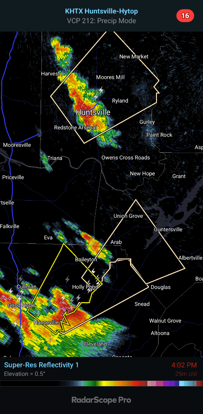
Here are some reports of damaging winds and hail from a few thunderstorms that became severe, or others that came close, late last week. The severe activity was isolated, but it did happen even around here. 

The National Weather Service in Nashville is still doing Weather101 classes, free and enjoyable. Looks like they are doing rip currents, tsunamis, and hurricanes next month. 

Meanwhile the Huntsville office has compiled a review of last year's significant weather events

And the Birmingham NWS offers a look back at the tornado outbreak of April 15, 2011. This actually felt like a big deal until the far worse outbreak that occurred a couple weeks later that year. This one mainly affected Central and South Alabama though. 

As usual, if anyone has any feedback on the attempts at Spanish, please feel free to leave a comment or send me an e-mail. I put a lot of effort into that when I do it, but like the meteorology, it is mainly self-taught. So there are going to be gaps in my knowledge. Usually I use Google Translate and then fix all its mistakes. Seems like a natural extension of fixing all the mistakes these computer models make in forecasting the weather and trying to read between the lines, figure out what it's really going to do. 

DISCUSSION:


Overall it has been a mostly sunny day in the Tennessee Valley, a light breeze at times as we've had a weak cold front moving through the region. Most of those clouds on the satellite imagery look like cirrocumulus and cirrostratus, if my eye has become trained over the years. If not, feel free to leave a comment and enlighten us as to what kinds of clouds are really showing up there. Any way you slice it, looking out the window even, we've got fair weather clouds today, and not too many of them, mostly the sunshine. The High in Cullman was 75 with a Low of 59. They got up to 79 degrees in Jasper despite more cloud cover throughout the day there, started the day with a Low of 48. In Haleyville the High was 77 after a morning Low of 56. 

And let's look at other places around the area. Fort Payne was another place that had more cloud cover today, and their High was 75 after a Low of 45. Gadsden also saw a High of 75, the Low was 46. And it's really a mixed bag as to the warmer spots, because Decatur got all the way up to 79 degrees today after a Low of 56. Huntsville actually saw 80 degrees after a Low of 57. Muscle Shoals also got up to 79 degrees, their morning Low 56. Tupelo topped out at 82, plenty of sunshine there today, after a morning Low of 56. Memphis dealt with a lot of clouds but still got up to 79 today, Low of 63. And then Nashville, the Music City, was mostly sunny, a bit more of a Northwest breeze than many of our other sites in the region today, a High of 77 and Low of 58. 


Today has been a quiet day across the country overall, but they do have some low-end severe thunderstorm potential out in Texas up through much of Oklahoma and into Kansas this evening and tonight. 


Around here the air will stay dry with the main player in our weather being the high pressure system that has moved off into the Atlantic. We'll have a Low of about 50 tonight and then warm up to about 77-78 tomorrow. Skies should be mostly sunny, and the chance of rain is so low during the day it's not worth putting into the forecast. Will mention a chance of isolated showers at night. 


Out in the Plains, a few storm chasers might have some fun, because they do have a risk for organized severe thunderstorms - including some supercell thunderstorms capable of damaging winds, very large hail, and tornadoes. 


The GFS wants to bring us some low-end rain chances lingering during the day Friday, but note that upper-level ridge holding pretty strong over the region too. 


The NAM keeps us dry, and I think that is more sensible. Forecasting partly mostly sunny skies Friday, any rain probably over in the very early morning (maybe when it's still dark), a High of about 80 or so, the Low near 60. 


It will be a breezy day as that warm front finishes moving through the region and our winds turn back to the South/Southeast. It would not be impossible to see a rain shower on Friday or during the day tomorrow, but the most likely timing is tomorrow night/early Friday morning, and even then, rain is expected to stay isolated, about a 20% chance. 


It does look like a rough day, stormy weather for places like Omaha to Kansas City back down to Dallas, large swath of mainly the Midwest and Mid-South having potential for organized severe thunderstorms, including supercells. 


Again on Saturday, around here I think the ridge of high pressure will still hold strong enough to keep the rain at bay. High should be near 80, Low of 60 or so. 


Though it looks like the Plains may have another rough ride of severe weather potential, the bullseye this time being centered on Oklahoma up into mainly Southeastern Kansas.  But some potential stretches all the way up to the Great Lakes region in Wisconsin. 

As a point of random trivia, I have managed to burn some fish and tater tots while writing this, to the point that my dear cat Salem has no interest in even the salmon patty. I don't mind eating burnt fish every now and then. 

But let's continue the extended outlook. 


Sunday looks like another calm day for us. Definitely a great weekend to get stuff done outside if you have even one day off work. Of course it's warming up as we get toward May. It's actually unusual for the weather to stay this dry and quiet this time in late April. This is more like May weather, where this ridge is keeping the storms out West. Basically the same deal, mostly sunny skies, High of 80 or so, Low of 60 or so. 


And again on Sunday it looks like severe thunderstorms will be possible across the Midwest and the Mid-South. 


On Monday we have the cold front with this system coming at us, with the Low way up in the Great Lakes region. At this point only going to mention an increase in clouds and a 20% chance of rain. 


And actually it keeps looking like this front will weaken or even "wash out" as it moves more into our area Monday night and Tuesday. So even for Tuesday, only including a 30% chance of rain/a thunderstorm. That ridge of high pressure off the Atlantic coast sure looks like it is going to help us out, as this is often a stormy time of the year. High staying near 80, Low staying near 60. 


Then next Wednesday, the first of May, looks like we can drop the rain chances and go with mostly sunny skies again, High in the lower 80's, Low in the upper 50's. 


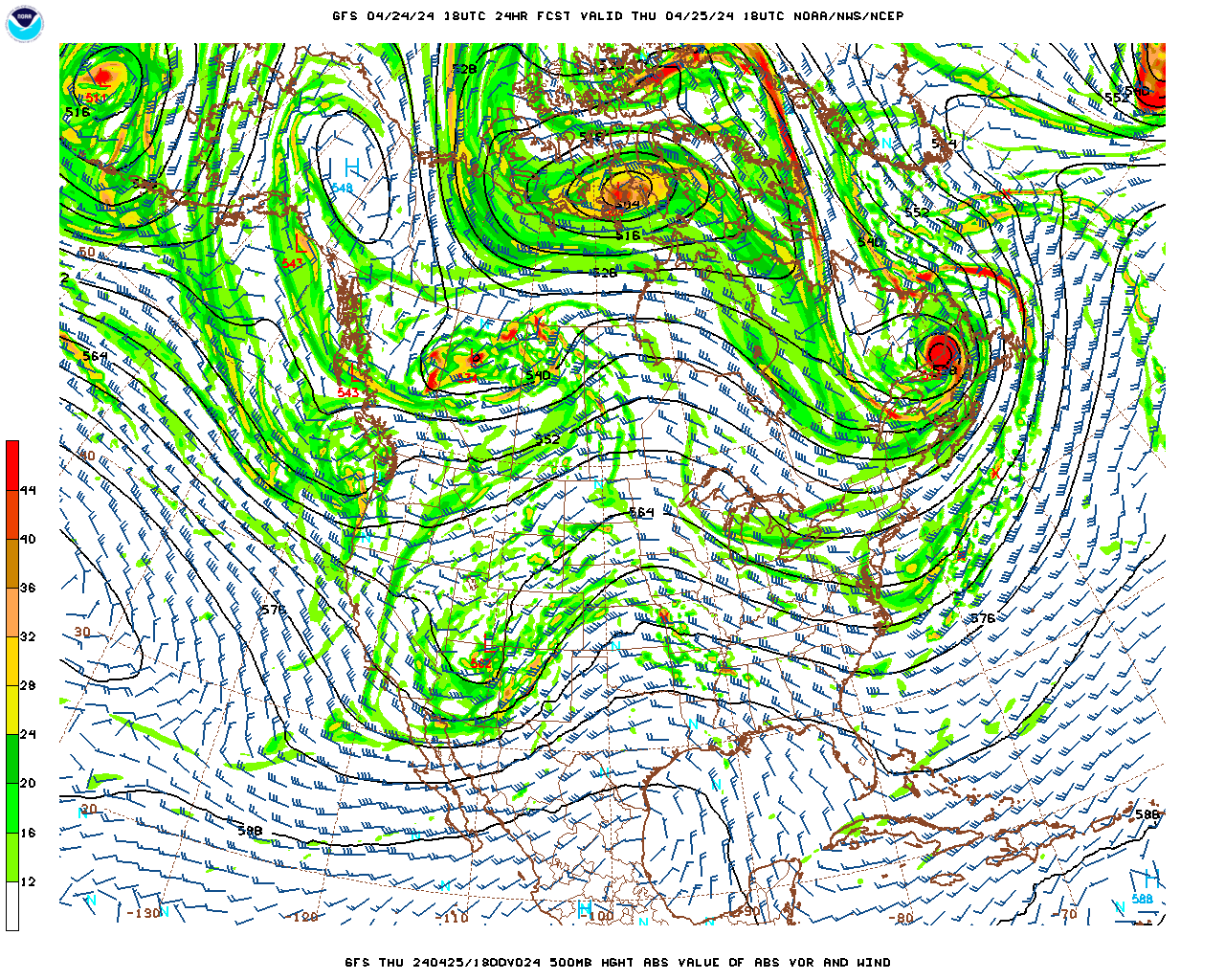
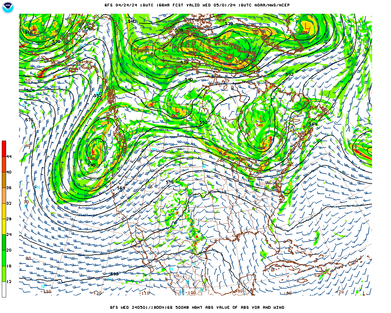
Average rainfall totals for this forecast period are expected to remain light, less than a quarter-inch even for Northwest Alabama up into Southern Middle Tennessee, and for the rest of us, less than a tenth of an inch as a rule. The major rains will be over the Midwest, Mid-South, and the Eastern Plains, where they'll have to watch for flash flooding issues along with the multiple chances for severe thunderstorms. The risk of flooding is on the low end via WPC guidance, so hopefully a lot of those folks will just get beneficial rain. Does look like a high threat for large hail in the storms, and also some potential for damaging winds and tornadoes. We can still have severe weather in May around here, especially the first couple weeks of May, but as of right now, there are no signs of that in the Southeast/Tennessee Valley any time soon. 


And a respectful salute to Bree "Sunshine" Smith for gracefully standing up for herself on social media. That requires a special knack. I still am trying to figure out why nobody harasses or threatens me. I can't even remember the last time somebody demanded to see my tits. And when I'm struggling with my weight, sometimes they can look about like a woman's. I refer you to Rodney Carrington's concerts archived on YouTube for further information. 

Severe Thunderstorm Wind and Hail Reports from Last Thursday and Friday

 000

NWUS54 KHUN 191121

LSRHUN


Preliminary Local Storm Report

National Weather Service Huntsville AL

621 AM CDT Fri Apr 19 2024


..TIME...   ...EVENT...      ...CITY LOCATION...     ...LAT.LON...

..DATE...   ....MAG....      ..COUNTY LOCATION..ST.. ...SOURCE....

            ..REMARKS..


0612 AM     Hail             2 N Russellville        34.53N 87.73W

04/19/2024  E1.00 Inch       Franklin           AL   Emergency Mngr


            Quarter size hail reported north of

            Russellville, AL. Time estimated based on

            radar.


&&


$$


000

NWUS54 KHUN 182315

LSRHUN


Preliminary Local Storm Report...Summary

National Weather Service Huntsville AL

615 PM CDT Thu Apr 18 2024


..TIME...   ...EVENT...      ...CITY LOCATION...     ...LAT.LON...

..DATE...   ....MAG....      ..COUNTY LOCATION..ST.. ...SOURCE....

            ..REMARKS..


0330 PM     Hail             6 SW Good Hope          34.05N 86.94W

04/18/2024  M0.88 Inch       Cullman            AL   Emergency Mngr


            Nickel size hail in Dodge City.


0340 PM     Tstm Wnd Dmg     5 S Good Hope           34.04N 86.88W

04/18/2024                   Cullman            AL   Public


            Trees down in Dodge City.


0353 PM     Tstm Wnd Dmg     1 W Hanceville          34.06N 86.78W

04/18/2024                   Cullman            AL   Public


            Trees and powerlines down near the

            intersection of Section Line and Magnolia

            Ave.


0355 PM     Hail             Hanceville              34.06N 86.76W

04/18/2024  M0.50 Inch       Cullman            AL   Emergency Mngr


            Dime size hail in Hanceville, AL.


0355 PM     Hail             2 NW Hanceville         34.08N 86.78W

04/18/2024  E0.75 Inch       Cullman            AL   Public


            Report from mPING: Dime (0.75 in.).


0402 PM     Hail             3 NE Hanceville         34.09N 86.72W

04/18/2024  M1.00 Inch       Cullman            AL   Broadcast Media


            Quarter size hail in Center Hill.


0438 PM     Hail             2 NNE Moores Mill       34.88N 86.52W

04/18/2024  E0.25 Inch       Madison            AL   Trained Spotter


            pea size hail near intersection of Moores

            Mill Rd and Oscar Patterson Rd.


&&


$$


000

NWUS54 KHUN 182245

LSRHUN


Preliminary Local Storm Report

National Weather Service Huntsville AL

545 PM CDT Thu Apr 18 2024


..TIME...   ...EVENT...      ...CITY LOCATION...     ...LAT.LON...

..DATE...   ....MAG....      ..COUNTY LOCATION..ST.. ...SOURCE....

            ..REMARKS..


0402 PM     Hail             3 NE Hanceville         34.09N 86.72W

04/18/2024  M1.00 Inch       Cullman            AL   Broadcast Media


            Quarter size hail in Center Hill.


&&


$$


KDW


000

NWUS54 KHUN 182205

LSRHUN


Preliminary Local Storm Report

National Weather Service Huntsville AL

505 PM CDT Thu Apr 18 2024


..TIME...   ...EVENT...      ...CITY LOCATION...     ...LAT.LON...

..DATE...   ....MAG....      ..COUNTY LOCATION..ST.. ...SOURCE....

            ..REMARKS..


0340 PM     Tstm Wnd Dmg     5 S Good Hope           34.04N 86.88W

04/18/2024                   Cullman            AL   Public


            Trees down in Dodge City.


&&


$$


KDW


000

NWUS54 KHUN 182151

LSRHUN


Preliminary Local Storm Report

National Weather Service Huntsville AL

451 PM CDT Thu Apr 18 2024


..TIME...   ...EVENT...      ...CITY LOCATION...     ...LAT.LON...

..DATE...   ....MAG....      ..COUNTY LOCATION..ST.. ...SOURCE....

            ..REMARKS..


0353 PM     Tstm Wnd Dmg     1 W Hanceville          34.06N 86.78W

04/18/2024                   Cullman            AL   Public


            Trees and powerlines down near the

            intersection of Section Line and Magnolia

            Ave.


&&


$$


KDW


000

NWUS54 KHUN 182144

LSRHUN


Preliminary Local Storm Report

National Weather Service Huntsville AL

444 PM CDT Thu Apr 18 2024


..TIME...   ...EVENT...      ...CITY LOCATION...     ...LAT.LON...

..DATE...   ....MAG....      ..COUNTY LOCATION..ST.. ...SOURCE....

            ..REMARKS..


0438 PM     Hail             2 NNE Moores Mill       34.88N 86.52W

04/18/2024  E0.25 Inch       Madison            AL   Trained Spotter


            pea size hail near intersection of Moores

            Mill Rd and Oscar Patterson Rd.


&&


$$


KDW


000

NWUS54 KHUN 182122

LSRHUN


Preliminary Local Storm Report

National Weather Service Huntsville AL

422 PM CDT Thu Apr 18 2024


..TIME...   ...EVENT...      ...CITY LOCATION...     ...LAT.LON...

..DATE...   ....MAG....      ..COUNTY LOCATION..ST.. ...SOURCE....

            ..REMARKS..


0330 PM     Hail             6 SW Good Hope          34.05N 86.94W

04/18/2024  M0.88 Inch       Cullman            AL   Emergency Mngr


            Nickel size hail in Dodge City.


0355 PM     Hail             2 NW Hanceville         34.08N 86.78W

04/18/2024  E0.75 Inch       Cullman            AL   Public


            Report from mPING: Dime (0.75 in.).


0355 PM     Hail             Hanceville              34.06N 86.76W

04/18/2024  M0.50 Inch       Cullman            AL   Emergency Mngr


            Dime size hail in Hanceville, AL.


&&


$$


000

NWUS54 KBMX 192157

LSRBMX


Preliminary Local Storm Report

National Weather Service Birmingham AL

457 PM CDT Fri Apr 19 2024


..TIME...   ...EVENT...      ...CITY LOCATION...     ...LAT.LON...

..DATE...   ....MAG....      ..COUNTY LOCATION..ST.. ...SOURCE....

            ..REMARKS..


0425 PM     Hail             Crudup                  34.11N 86.01W

04/19/2024  E0.75 Inch       Etowah             AL   Broadcast Media


&&


$$


000

NWUS54 KBMX 191849

LSRBMX


Preliminary Local Storm Report

National Weather Service Birmingham AL

149 PM CDT Fri Apr 19 2024


..TIME...   ...EVENT...      ...CITY LOCATION...     ...LAT.LON...

..DATE...   ....MAG....      ..COUNTY LOCATION..ST.. ...SOURCE....

            ..REMARKS..


0720 AM     Tstm Wnd Dmg     1 NNE Haleyville        34.25N 87.61W

04/19/2024                   Winston            AL   Public


            Trees uprooted and powerlines down on

            Newburg Rd.


&&


$$


AS


000

NWUS54 KBMX 191843

LSRBMX


Preliminary Local Storm Report

National Weather Service Birmingham AL

143 PM CDT Fri Apr 19 2024


..TIME...   ...EVENT...      ...CITY LOCATION...     ...LAT.LON...

..DATE...   ....MAG....      ..COUNTY LOCATION..ST.. ...SOURCE....

            ..REMARKS..


0725 AM     Tstm Wnd Dmg     1 ESE Haleyville        34.23N 87.61W

04/19/2024                   Winston            AL   Broadcast Media


            Tree on a home on 18th Ave. Other trees also

            reported down in the Haleyville area.


&&


$$


AS


000

NWUS54 KBMX 191302

LSRBMX


Preliminary Local Storm Report

National Weather Service Birmingham AL

802 AM CDT Fri Apr 19 2024


..TIME...   ...EVENT...      ...CITY LOCATION...     ...LAT.LON...

..DATE...   ....MAG....      ..COUNTY LOCATION..ST.. ...SOURCE....

            ..REMARKS..


0725 AM     Hail             Haleyville              34.23N 87.62W

04/19/2024  E0.50 Inch       Winston            AL   Cocorahs


            CoCoRAHS report of hail in Haleyville.


&&


$$


AS


000

NWUS54 KOHX 191122

LSROHX


Preliminary Local Storm Report...Summary

National Weather Service Nashville TN

622 AM CDT Fri Apr 19 2024


..TIME...   ...EVENT...      ...CITY LOCATION...     ...LAT.LON...

..DATE...   ....MAG....      ..COUNTY LOCATION..ST.. ...SOURCE....

            ..REMARKS..


0656 PM     Hail             2 E Coopertown          36.44N 86.93W

04/18/2024  E1.00 Inch       Robertson          TN   Public


0702 PM     Hail             3 E Coopertown          36.42N 86.91W

04/18/2024  E0.75 Inch       Robertson          TN   Public


            Report from mPING: Dime (0.75 in.).


0709 PM     Hail             3 SSE Springfield       36.46N 86.85W

04/18/2024  M1.00 Inch       Robertson          TN   Public


0714 PM     Tstm Wnd Dmg     Springfield             36.50N 86.88W

04/18/2024                   Robertson          TN   Emergency Mngr


            A tree fell on a house on Shelton St causing

            minor to moderate damage to the house.


&&


$$


000

NWUS54 KOHX 190120

LSROHX


Preliminary Local Storm Report

National Weather Service Nashville TN

820 PM CDT Thu Apr 18 2024


..TIME...   ...EVENT...      ...CITY LOCATION...     ...LAT.LON...

..DATE...   ....MAG....      ..COUNTY LOCATION..ST.. ...SOURCE....

            ..REMARKS..


0714 PM     Tstm Wnd Dmg     Springfield             36.50N 86.88W

04/18/2024                   Robertson          TN   Emergency Mngr


            A tree fell on a house on Shelton St causing

            minor to moderate damage to the house.


&&


$$

Tuesday, April 23, 2024

Mostly Dry Pattern Holds, Warming Up Again, Maybe Some Rain Next Week

FORECAST:

Wednesday (High 73, Low 50): Mostly sunny. Mild. 

Thursday (High 77, Low 52): Partly cloudy with isolated showers/thunderstorms possible during the day. Rain may increase in coverage at night but should stay fairly scattered. 

Friday (High 80, Low 60): Partly cloudy. Widely scattered showers and thunderstorms are still possible.

EXTENDED OUTLOOK:

Saturday (High 83, Low 62): Mostly sunny.

Sunday (High 82, Low 63): Partly to mostly sunny. 

Monday (High 81, Low 62): Partly cloudy with a 30% chance of showers/thunderstorms.

Tuesday (High 80, Low 63): Partly to mostly cloudy with a 40% chance of showers/thunderstorms. 

Saturday, April 20, 2024

Rain Coming to an End, Turning Cooler, Staying Sunny and Mild Next Week

FORECAST:

Sunday (High 60, Low 46): Scattered lingering showers possible in the morning. Mostly sunny in the afternoon with a very cool breeze. 

Monday (High 67, Low 40): Sunny. Cool.

Tuesday (High 72, Low 39): Sunny. Cool.

EXTENDED OUTLOOK:

Wednesday (High 75, Low 48): Mostly sunny. 

Thursday (High 76, Low 50): Mostly sunny. 

Friday (High 78, Low 57): Partly cloudy. 

Saturday (High 80, Low 60): Partly cloudy with a 20% chance of showers/thunderstorms. 

Friday, April 19, 2024

Turning Cooler, Rain Clearing Out By Monday

Saturday (High 67, Low 56): Mostly cloudy and cool. Widely scattered showers are possible. 

Sunday (High 58, Low 47): Overcast and cold. Numerous showers are possible.

Monday (High 68, Low 40): Mostly sunny. Staying cool.

Tuesday (High 73, Low 39): Sunny. 

Wednesday (High 75, Low 48): Mostly sunny. 

Thursday (High 78, Low 51): Mostly sunny.

Friday (High 80, Low 54): Partly cloudy. 

Staying Wet This Weekend But Cooling Off/Sunny Skies Return for the Workweek

FORECAST:

Friday (High 80, Low 63): Partly cloudy. Scattered showers and thunderstorms are possible. 

Saturday (High 70, Low 56): Partly to mostly sunny and cooler. Widely scattered showers are possible. 

Sunday (High 57, Low 46): Mostly overcast and cold. Numerous rounds of showers are possible.

EXTENDED OUTLOOK:

Monday (High 66, Low 40): Sunny. 

Tuesday (High 75, Low 43): Sunny. 

Wednesday (High 77, Low 50): Mostly sunny. 

Thursday (High 79, Low 52): Mostly sunny. 

READING TEA LEAVES:

Friday April 26th through Sunday April 28th (High ~80, Low ~60): Partly cloudy with a 20% chance of showers/thunderstorms. 

Thursday, April 18, 2024

T'Storm Warning


 We may see a few more storms like this through the evening, but this warning was issued for the size of the hail, not even for possibility of wind damage.  


3:59 PM - There is another strong thunderstorm over Northwest Huntsville that may produce gusty winds up to 30 mph or so and some smaller hail, like pea-sized. That is well below severe limits. And there is a thunderstorm in Lawrence County (Tennessee, not Alabama) that is behaving itself. 


4:03 PM - For storms like this, you don't have to take tornado-level precautions. Basically just stay inside, away from windows or anything electrical, and you'll be fine. I wouldn't try to drive through them though. Even quarter-sized hail, gusty winds, and lots of lightning would be enough to make me want to pull over somewhere and let it pass. 


4:07 - Now a special weather statement has been issued for Northern Blount County, affecting places like Blountsville and Strawberry. Most of any storms we get this evening should stay below severe limits, and the hail in this Cullman County storm just barely made it there. But it did verify with some pictures I saw scrolling social media. That storm up across the TN state line is not only staying below severe criteria but looks more like a shower at this point, not even seeing lightning with it now. 


4:12 - This storm definitely verified with some severe hail as it moved through Dodge City. But just to be clear, the wind gusts are expected to stay about 30 mph with this. The warning was issued purely based on the size of the hail. 


4:15 - And let me just go ahead and eat my words! Trees and powerlines have now been reported down in Hanceville by emergency management. Mentioned in the update to the warning, now expecting wind gusts up to 60 mph. So this storm is worth watching as it moves northeast. So I'd try to get away from windows in a house, better if you are on the lower floor. If you've got trees around, might want to move to a smaller space like a hallway just in case one were to fall. It's tougher for them to collapse the walls than in an open area like a living room or kitchen. 


4:20 - And that storm is up to Holly Pond now. The one moving through Huntsville is staying below severe limits. 


4:28 - As the storm moves up toward Arab, only wind gusts up to 40 mph and pea-sized hail are expected. So this Severe Thunderstorm Warning is being replaced by a Special Weather Statement as the storm tracks Northeast. 


4:31 - Going to drop real-time weather coverage since these thunderstorms are fairly isolated and none are severe anymore. 

4:37 - Most of the news I find depressing and pointless to comment on. But I did see a lovely story from WBRC/FOX-6 in Birmingham today. 

I really think the world would be a better place if there were more women with this kind of gumption. If it was up to me, the cheating husband and mistress would be the ones arrested. That guy should count himself lucky he only got shot in the leg, it was easy to fix. And that other woman was not a victim at all. Standards have become so upside-down. And if you look at that woman's mugshot, any guy who was cheating on her had to be an idiot anyway. 

Lest anyone think I've become a feminist, I fully supported Johnny Depp over Amber Heard. So as usual, both sides of popular debate are free to hate on me. I find it fun. 

Glad the weather calmed down enough to speak of more pleasant things. Some country music might hit the spot this evening . . . 

Severe Thunderstorm Warning

ALC043-182130-

/O.NEW.KHUN.SV.W.0029.240418T2041Z-240418T2130Z/


BULLETIN - IMMEDIATE BROADCAST REQUESTED

Severe Thunderstorm Warning

National Weather Service Huntsville AL

341 PM CDT Thu Apr 18 2024


The National Weather Service in Huntsville Alabama has issued a


* Severe Thunderstorm Warning for...

  Central Cullman County in north central Alabama...


* Until 430 PM CDT.


* At 340 PM CDT, a severe thunderstorm was located near Dodge City,

  or 9 miles south of Cullman, moving northeast at 20 mph.


  HAZARD...Quarter size hail.


  SOURCE...Radar indicated.


  IMPACT...Damage to vehicles is expected.


* Locations impacted include...

  Cullman, Hanceville, Good Hope, Holly Pond, Dodge City, Baileyton,

  Eva, Garden City, Phelan, and Walter.


PRECAUTIONARY/PREPAREDNESS ACTIONS...


For your protection move to an interior room on the lowest floor of a

building.


&&


LAT...LON 3405 8692 3431 8675 3431 8670 3418 8655

      3415 8659 3412 8660 3412 8663 3409 8666

      3408 8669 3409 8669 3408 8670 3405 8668

      3406 8671 3403 8670 3403 8672 3397 8678

TIME...MOT...LOC 2040Z 233DEG 18KT 3404 8683


HAIL THREAT...RADAR INDICATED

MAX HAIL SIZE...1.00 IN

WIND THREAT...RADAR INDICATED

MAX WIND GUST...<50 MPH


$$


GH

Messy, Unsettled Pattern Through the Weekend/Sunny and Cool Going Into Next Week


FORECAST:

Today (High 82): Partly to mostly sunny with an isolated shower or thunderstorm possible during the day. Numerous showers are possible at night. 

Friday (High 80, Low 63): Partly to mostly cloudy. Scattered showers and thunderstorms are possible. 

Saturday (High 70, Low 55): Partly to mostly cloudy and turning cooler. Widely scattered showers are possible.

Sunday (High 58, Low 49): Overcast and cool. Numerous rounds of showers are possible. 

EXTENDED OUTLOOK:

Monday (High 67, Low 42): Mostly sunny. 

Tuesday (High 74, Low 44): Sunny. 

Wednesday (High 78, Low 50): Mostly sunny. 

Thursday (High 79, Low 54): Partly cloudy. 

Wednesday, April 17, 2024

 Hey peeps, just a quick note to say the weekend is looking wet, unlike when I last had time to write up a forecast.

Very low chance of an isolated strong storm today through Friday, but overall it just looks like regular rain and thunderstorms, the strongest part of this storm system staying well to our North up around the Great Lakes. 

Just to brush over things, showers and storms are likely at times today with a High near 78.

Tomorrow any showers or thunderstorms should stay isolated, with a good bit of sun along with the clouds. The High in the lower 80's, morning Low near 60.

As we get into Friday, more of a chance of scattered showers and thunderstorms again, about 40% rain chance, High near 80, Low in lower 60's. The Storm Prediction does have us in a marginal risk for an isolated thunderstorm reaching severe limits between now and Friday, but this is a very, very low risk that I'm not worried about.

As the front pushes through Saturday we'll drop to about 70 degrees for the High, down in the 50's again for the Low, rain chances staying scattered, about 30%.

Then the last wave of this system will increase our rain chances Sunday back to at least 50%. We'll see a High near 60 and a Low only in the upper 40's.

After that it looks sunny with Highs in the 70's and Lows back down in the 40's.

By next Wednesday it should be back to 80 or so for the High, Lows rebounding to 50's. If we can rely on the model trends, looks like we may actually stay mostly sunny and dry into the following weekend. But this time of year, best to keep a check on it every two or three days, because weather patterns can change a lot faster than they do in the summer. Just letting you know things are looking pretty good at this point. After the periods of rain through this weekend.


Saturday, April 13, 2024

Mostly Sunshine and Warm Temperatures, Some Scattered Rain Midweek Before a Cool Snap

FORECAST:

Sunday (High 80, Low 50): Mostly sunny. Low humidity.

Monday (High 82, Low 54): Mostly sunny. Cool in the morning, warm in the afternoon. 

Tuesday (High 81, Low 59): Partly to mostly cloudy. Widely scattered showers/thunderstorms are possible at night.

EXTENDED OUTLOOK:

Wednesday (High 78, Low 62): Mostly cloudy with a 40% chance of showers/thunderstorms.

Thursday (High 80, Low 61): Partly to mostly cloudy with a 30% chance of showers/thunderstorms.

Friday (High 74, Low 58): Partly to mostly cloudy with a 20% chance of lingering showers.

Saturday (High 70, Low 50): Partly to mostly sunny. 

Mostly Warm and Dry Pattern, a Little Rain Possible Next Week

FORECAST: Thursday (High 78, Low 50): Partly to mostly sunny. Isolated showers are possible at night.  Friday (High 81, Low 60): Partly to m...