

First, let's get today (Monday) out of the way. A tornado outbreak may happen for places like Oklahoma City, Wichita, Kansas City. It doesn't look good out there. A lot of their supercells will likely produce very large hail too, classic supercells that could easily turn tornadic. Around here, we just have a low-end chance of a few isolated storms being able to produce severe wind gusts or large hail, but the kind measured in coin sizes, not ball sizes. That's for today, Monday. And a lot of us won't see any rain at all, much less storms today.

Tomorrow, Tuesday, looks a bit more concerning. When I saw this new outlook, I thought it was worth passing along right away. Most of the Tennessee Valley has been included in the Level 3/5 Enhanced Risk for severe thunderstorms. And then the rest of the area (mainly far Northeast Alabama) is under the Level 2/5 Slight Risk, which is the standard basic risk.

The initial storm mode is expected to be supercell thunderstorms, the kinds that form out by themselves in a favorable environment. So they get to hog all the fuel and sustain for a long time. And there is a decent chance that these storms could produce tornadoes.
So a lot of us are under that 10% risk of a tornado within 25 miles of a given point.

Just about the only places under the more basic 5% isolated tornado risk around here are places like Scottsboro and Rainsville, in far Northeast Alabama. By the time the storms get there, this will probably have merged into a squall line. So the tornado risk will be lower.
As of right now, it looks like the supercell thunderstorms are most likely to form in North/Central Mississippi and track up into Tennessee and North Alabama. This hot zone for supercells capable of producing tornadoes also reaches into Western Kentucky. And the reason this area is hatched is to let people know that these could produce some of the longer-lived tornadoes that are capable of more significant damage, the kind that would have to be rated at least E/F-2 on the Enhanced Fujita/Pearson Scale. And for people who are not familiar with the scale, an E/F-2 tornado is strong enough to completely level a mobile home or throw it across the road, and take all the roofing off even a well-built frame house.
It's questionable exactly where and when the storm mode will turn into more of a linear one, but this latest guidance from the SPC is telling nearly all of us in North Alabama - Huntsville, Cullman, points West, also all of our Tennessee neighbors - to be alert for a supercell thunderstorm possibly coming your way during this event, that could produce a tornado. So it's important to take this seriously.


The chance of seeing damaging wind gusts is also a little enhanced in these areas. I was surprised that they're just giving a basic large hail threat, for coin-sized hail. I saw some things in the past few days that made me wonder if we could have larger hail in the supercells, like golfball-sized, but then I also remember reading some reasoning from more experienced forecasters about some things that could limit the hail threat. And it looks like that's what the Storm Prediction Center is going with here.


But some of us could see some fairly dangerous thunderstorms out of this, regardless of whether they end up producing a tornado or not. Even if they're just blowing hail around and taking out trees and power lines, or maybe busting out a window here and there, that is dangerous enough to respect the threat.
And of course, if we do see tornadoes out of this (a good possibility), that's even more serious.

For a quick safety review, some of this may come in during the night hours. The most likely timing for these severe storms is Tuesday evening and night for North Alabama and Southern Middle Tennessee.
So you need a way to get Tornado Warnings that will wake you up. At the very least, enable Wireless Emergency Alerts on your cell phone. That won't catch a Severe Thunderstorm Warning unless it carries a tag that the danger is really elevated (like what happened yesterday morning in South Birmingham and points East of there), but it will get you Tornado Warnings.
It's better if you have a NOAA Weather Radio with battery backup, properly programmed. Or if you're relying on the phone route, a service like WeatherCall.
Remember that a Tornado Watch just lets you know that conditions are favorable for severe thunderstorms capable of producing tornadoes, in and close to the Watch area. People in those areas should remain alert to rapidly changing weather conditions and be prepared to take shelter within five minutes of getting a warning, or if threatening weather approaches. (There's still something to be said for keeping an eye to the sky and trusting your gut sometimes.)
A Tornado Warning means that a tornado is believed to be developing or already happening within the Warning polygon. People anywhere within that polygon should take immediate action to protect themselves. The warning is often based on radar, but sometimes it's also based on a reliable report.
First off, you have to get out of a mobile home or a vehicle. Many of our tornado deaths still happen because people get caught in a trailer or out driving. I would abandon a mobile home and lie flat on the ground or in an unflooded culvert or ditch if that's the best I could do.
But with some planning, usually people can do better. In a site-built house or other reasonably sturdy building (and that can be a nearby grocery store, gas station, or restaurant that's open), the basic ideas for sheltering are:
* Stay away from windows.
* Get to the lowest floor.
* Get into a smaller room - like a bathroom, closet, or hallway.
* Make that room as near the center of the building as you can. Or put as many walls between you and the outside as you can.
* Cover your body from falling or flying debris. Especially protect your head. If you have a safety helmet, great, use that. If all you have is a pillow or some blankets, use what you've got. If the best you can do is get up under something sturdy, like a table or desk, set of stairs, or a workbench, then use that.
Taking these precautions, you're going to survive a tornado about 90-99% of the time, even if it turns out to be a really bad one. And most of the time, you can get by without injury.
Of course, if you do have access to a proper tornado shelter, or the underground part of a basement, that offers the best protection. Not a lot of people do these days, so if you've got that, please consider welcoming people into it if you can safely do so. (Or to put it more bluntly, as long as somebody's not on crack and wielding a hatchet, or trying to steal your stuff to sell and then go out and buy meth with the money, then you can probably afford to be generous.) Especially if somebody lives in a weaker structure like a mobile home or maybe an apartment up on the top floor (and they don't have welcoming neighbors downstairs), you could help save somebody's life that way . . . in some cases.
All right, so this is another situation where we'll try to be prepared for the worst and hope for the best. I've certainly seen plenty of more threatening tornado setups than this over the years, and we had one that looked more threatening earlier this year, on March 15. But this looks bad enough that I really want to encourage people to take it seriously and look out for each other. This is not one that I would blow off and say, "Aw, it ain't gonna' do nuthin'." It probably is going to do something for some of us in North Alabama/Southern Tennessee. It's only a matter of where and how bad the weather gets. Sometimes you can get a bust with a setup like this, but it is much more likely that at least some of us are going to have some issues out of this setup. So please take care of yourself and your loved ones. The weather behind this storm system looks excellent, best you could ask for this time of year. But to get to that, we have to get through these storms. And it could get ugly for some of us. It's one of those days/nights we have to buckle down and think about putting first things first, protecting people.
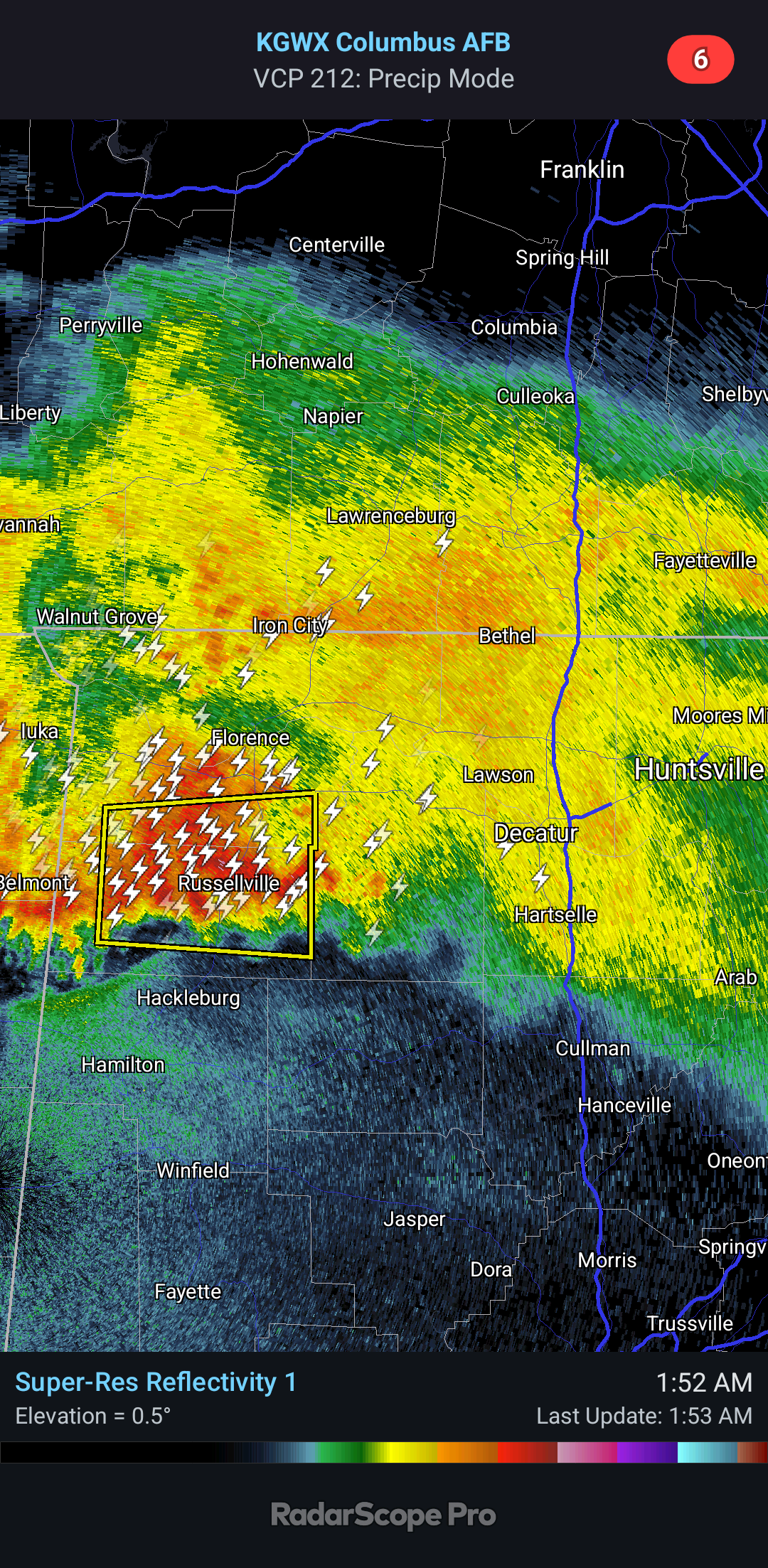
1:53 AM - And I just noticed this severe thunderstorm warning that includes Russellville, for 60 mph wind gusts mainly. I'm going to save my energy for the more organized stuff, or if we get anything random like this closer to home base (Cullman, Walker, Winston counties).
When the air is staying this muggy, you can get random thunderstorms that reach severe limits like this. It's sort of like the stronger storms we see in the summertime. But this stuff lately has been focused along a pesky stationary front.
SPC AC 190556
Day 2 Convective Outlook
NWS Storm Prediction Center Norman OK
1256 AM CDT Mon May 19 2025
Valid 201200Z - 211200Z
...THERE IS AN ENHANCED RISK OF SEVERE THUNDERSTORMS FOR PORTIONS OF
THE MID-MISSISSIPPI VALLEY...OHIO VALLEY...AND TENNESSEE VALLEY...
...SUMMARY...
Severe thunderstorms are likely across portions of the Ohio Valley,
Mid-Mississippi Valley, and Tennessee Valley on Tuesday.
...Synopsis...
A mid-level trough will advance east to the TN/OH Valley by Tuesday
afternoon/evening. At the surface, a surface low will move from
northern MO/southern Iowa to the eastern Great Lakes by 12Z
Wednesday. A cold front will extend south from this surface low and
move east from the central/southern Plains at the beginning of the
period to the eastern Great Lakes to Louisiana Coast by 12Z
Wednesday.
...Mid-Mississippi Valley into the Ohio/Tennessee Valleys...
Remnant Day 1 convection will likely be ongoing at the beginning of
the period from the Midwest into the Ohio Valley with the potential
for some ongoing strong to severe storms. One or more outflow
boundaries will likely be located across the Ohio River region at
the beginning of the period. 00Z guidance has come into better
agreement that a mid-level dry slot associated with the mid-level
jet streak will move quickly across the warm sector during the
morning. This will allow heating and recovery across most of the
warm sector, particularly south of the Ohio River. This was the
primary factor which supported expansion of the Enhanced Risk into
southern Kentucky.
Moderate to potentially strong instability is forecast to develop
across the warm sector by the early afternoon. Thunderstorm
development will likely occur rather early in the afternoon as
inhibition will be quickly eroded and upper-level forcing should
overspread the warm sector during the afternoon. A 60 to 70 knot
mid-level jet will overspread the warm sector and provide a very
favorable supercell wind profile across most of the region. Initial
supercells will pose a threat for all severe weather hazards
including the potential or strong tornadoes. The uncapped warm
sector and strong forcing suggest that eventual upscale growth is
likely into several squall lines/clusters. Severe wind and
line-embedded tornadoes (particularly where the line orientation
becomes more favorable to the low-level shear vector) will become
more likely by the evening as this more linear mode evolves.
...Carolinas into southern Virginia...
A warm front is forecast to lift northward across the region during
the day, allowing for a corridor of rich boundary-layer moisture to
spread across parts of SC/NC/western VA. Vertically veering,
supercell wind profiles along this boundary, and MLCAPE to 1500 J/kg
MLCAPE is evident in forecast soundings. This could support a few
strong to severe storms during the late afternoon or evening as
modest height falls overspread the region.
..Bentley.. 05/19/2025
No comments:
Post a Comment