


This clips extreme Northeast Cullman County, and that's why the sirens are going off, I believe countywide. But the storm is near Arab and headed in the direction of Guntersville. Albertville is also in the polygon.
8:58 - Please note that people in the city of Cullman are just getting rain. This barely clips the very far NE corner of Cullman County - like Joppa/Arab is all that's included basically.
9 PM - In these two polygons are where people need to take shelter. Or in the case of the Dekalb County storm, stay sheltered. Hopefully have been sheltered for a long time now.
9:01 - I'd like to correct something James Spann said. He said we don't know how the Dekalb Co. warning is confirmed. Actually the text of the warning from NWS Huntsville specifies it was from broadcast media. I don't know what channel. Things have been so busy that I haven't seen that while scrolling.
Okay, and somebody from Huntsville also just told him that between Section and Sylvania, a private radar is showing debris being picked up into the air.
9:03 - And again, even if you are hearing tornado sirens in Cullman County, there is no tornado warning for anyone in Cullman County except the far Northeast part of the county, like around Joppa. City of Cullman not affected, not even Vinemont or Holly Pond. And of course it doesn't affect places like Hanceville, Bremen, Colony, or Arkadelphia. Just throwing that in before focusing on the people who do need attention for this new warning.
.png)
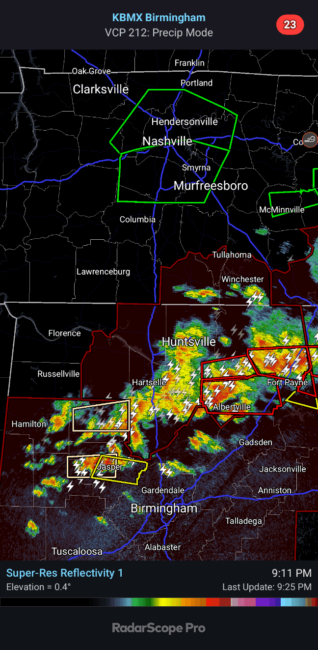
9:06 - Let's take a good look at it.
Unfortunately the velocity is not coming through but just looking at reflectivity you can see the polygon. Guntersville, Albertville, Geraldine, Crossville, communities near there in this polygon need to be in shelter.
9:10 - James Spann just showed some of the impressive lightning from Cullman on his live stream, looking back toward this storm in Marshall County that looks like it may have a tornado in it.
9:12 - And it seems that tornado sirens are sounding in Cullman County again even though its NE corner was dropped from the tornado warning. I'm not sure why.

There is a strong thunderstorm coming out of Winston County, but at last check it was below severe limits. Also a strong storm in Walker County.
At times these storms have shown rotation, but it's been really broad so far.

9:16 PM - Meanwhile we have multiple tornadic circulations in Northeast Alabama. I'd stay sheltered in any of these polygons, don't wait on a confirmation.

9:18 - And we just got a severe thunderstorm warning that includes Jasper, Sipsey, and Sumiton.
9:25 - Here is the broad view. Strong thunderstorms are moving through Cullman with a lot of lightning. The storm in Jasper has reached severe limits. But Northeast Alabama is still the main show with multiple tornado warnings in effect.
And boy the radar images are starting to lag.
There we go. I was able to post the radar above.
We have confirmed tornadoes in Dekalb and Cherokee Counties. But all of these tornado polygons, I'd take shelter. Stay in shelter. And even that severe thunderstorm warning in Walker County, I'd get to a reasonably safe place until that storm passes.

9:30 - And here's the latest confirmed tornado warning over the same basic area there in Dekalb County.

9:32 - Here are our remaining tornado warning polygons in NE AL.
Strong thunderstorms are moving through Cullman County, but as far as I can tell, none of them are at severe limits. They do have some gusty winds, maybe very small hail, definitely a lot of lightning. But I have not even seen a Special Weather Statement issued for an unusually strong thunderstorm at this point.

9:35 - Here is the broad view again. The severe thunderstorm is out of Jasper and aiming at places like Sumiton and Dora now.
Brad Travis is mentioning how radar does make it look like as the storms head toward Holly Pond, Hanceville, Blountsville, some signs that wind damage may be possible. I think he's right. It bears watching. If you're in Cullman County as these storms come through, if you feel threatened, it won't hurt to move to a safer place in your home. Especially if you've got trees around.

9:37 - And we just got a Special Weather Statement for the bulk of Cullman County where this squall line is coming through. They mention wind gusts up to 50 mph, which is below severe levels, but is still some pretty stout wind. Once in a while you can still have tree damage from that. So if you don't feel right about it, please, go ahead and move to a safer spot in your home. It won't hurt anything. And if a tree or something did come down, you might be glad you did. This night has been full of surprises.
This SWS also affects Morgan, Marshall, Madison, and Jackson Counties.

9:40 - But the real danger zone is for the storms coming through communities like Crossville, Geraldine, Lakeview, Fyffe, Sylvania, Henagar, Valley Head. These are the areas that keep showing tornado circulations on radar. And even though it's at night, sometimes these are continuing to be confirmed.
So in those areas, you need to move to a small interior room (or hallway) on the lowest floor of a sturdy house (not a mobile home), away from windows, if in those warning polygons.

9:46 - Now a Special Weather Statement extended into Blount County.

9:48 - Also places like Cedar Bluff, Powell, Gaylesville in Cherokee County, be in shelter from this Tornado Warning. Cover your body, especially your head as best you can. Whether that's blankets, a pillow, a helmet, or just getting up under a sturdy workbench or set of stairs.
That's good advice for any of these Tornado Warnings.
We have severe radar limitations tonight, but we know enough to tell you that in ANY of these tornado warning polygons tonight, you need to get to shelter and stay there. Don't wait to know it's coming right down your street or something. The radar near Huntsville is OUT, and we're mainly relying on radar out of Birmingham. But we're doing the best we can. Your part is to take these warnings seriously - protect yourself and your loved ones.
We had a really bad-looking tornado at least graze Northern Huntsville and Madison earlier today - won't know the details until at least tomorrow. But you have to respect the storms tonight. Even if it's a tornado that spins up quickly and may not last long. It can hurt or kill you IF you don't take shelter. And so far we've heard of no injuries. Let's try to keep it that way as much as we can, all right?

9:53 - By the way, Huntsville - Shoals - Florence - Decatur - Athens - and all our bordering TN counties - ALL CLEAR. Severe weather is over for the night, and the next few days look lovely.
If you are still under the yellow shading above, you are still under the Tornado Watch. They are clearing that out behind the squall line. But until you are in the clear, be aware that severe weather is still possible.
It is mainly in Northeast Alabama now though.
9:55 - The warning for Walker was allowed to expire on time.
And really once this squall line passes, you're good for the night. But if you're not sure, wait until the Tornado Watch is cancelled for your area. Then call it a night.

9:57 - Again if you are covered by any of these Tornado Warning polygons that affect Dekalb, Cherokee, or Etowah Counties - STAY SHELTERED.
We are operating under a handicap tonight because we had a radar go down that we normally rely on. And we're just playing it safe. If anything looks like it's trying to produce a tornado, you need to take shelter and don't worry about whether it's confirmed or not. I know one of the ones in Dekalb County was still confirmed earlier, even with radar limitations and it being at night.
I think there is a new warning for Dekalb.
If so I'm going to make a new post for it. Instead of trying to illustrate here.
Tornado Warning
ALC043-049-095-210245-
/O.NEW.KHUN.TO.W.0052.250521T0152Z-250521T0245Z/
BULLETIN - EAS ACTIVATION REQUESTED
Tornado Warning
National Weather Service Huntsville AL
852 PM CDT Tue May 20 2025
The National Weather Service in Huntsville Alabama has issued a
* Tornado Warning for...
Marshall County in northeastern Alabama...
Southwestern DeKalb County in northeastern Alabama...
Northeastern Cullman County in north central Alabama...
* Until 945 PM CDT.
* At 852 PM CDT, a severe thunderstorm capable of producing a tornado
was located over Arab, moving east at 50 mph.
HAZARD...Tornado.
SOURCE...Radar indicated rotation.
IMPACT...Flying debris will be dangerous to those caught without
shelter. Mobile homes will be damaged or destroyed.
Damage to roofs, windows, and vehicles will occur. Tree
damage is likely.
* This dangerous storm will be near...
Guntersville around 900 PM CDT.
Albertville around 905 PM CDT.
Crossville and Geraldine around 920 PM CDT.
Other locations impacted by this tornadic thunderstorm include
McVille, High Point, Lakeview, Hopewell, Guest, Columbus City,
Skirum, Lake Guntersville St Park, Lebanon, and Eddy.
PRECAUTIONARY/PREPAREDNESS ACTIONS...
TAKE COVER NOW! Move to a basement or an interior room on the lowest
floor of a sturdy building. Avoid windows. If you are outdoors, in a
mobile home, or in a vehicle, move to the closest substantial shelter
and protect yourself from flying debris.
&&
LAT...LON 3426 8581 3424 8581 3424 8584 3420 8585
3421 8642 3426 8644 3426 8648 3425 8652
3422 8653 3422 8659 3444 8657 3447 8609
3446 8608 3448 8602 3449 8583 3426 8577
TIME...MOT...LOC 0152Z 266DEG 44KT 3430 8650
TORNADO...RADAR INDICATED
MAX HAIL SIZE...<.75 IN
$$
GH


No comments:
Post a Comment