

FORECAST:
Monday (High 86, Low 66): Partly to mostly cloudy. An isolated shower or thunderstorm is possible.
Tuesday (High 85, Low 68): Mostly cloudy, muggy, and breezy with scattered showers and thunderstorms possible during the day. Thunderstorms are likely in the evening and night hours, and some may be severe.
Wednesday (High 79, Low 62): Sunny. Starting to turn cooler.
EXTENDED OUTLOOK:
Thursday (High 72, Low 54): Sunny.
Friday (High 71, Low 48): Sunny.
Saturday (High 74, Low 52): Partly to mostly sunny with a 20% chance of showers.
Sunday (High 80, Low 56): Partly to mostly sunny with a 20% chance of showers/thunderstorms.
PRONÓSTICO:
Lunes (Máxima: 86, Mínima: 66): Parcialmente a mayormente nublado. Posibles lluvias o tormentas aisladas.
Martes (Máxima: 85, Mínima: 68): Mayormente nublado, bochornoso y ventoso, con posibles chubascos dispersas durante el día. Es probable que haya tormentas por la tarde y la noche, algunas de las cuales podrían ser severas.
Miércoles (Máxima: 79, Mínima: 62): Soleado. Empezará a refrescar.
PERSPECTIVA EXTENDIDA:
Jueves (Máxima: 72, Mínima: 54): Soleado.
Viernes (Máxima: 71, Mínima: 48): Soleado.
Sábado (Máxima: 74, Mínima: 52): Parcialmente a mayormente soleado con un 20% de probabilidad de chubascos.
Domingo (Máxima: 80, Mínima: 56): Parcialmente a mayormente soleado con un 20% de probabilidad de chubascos.
DISCUSSION:
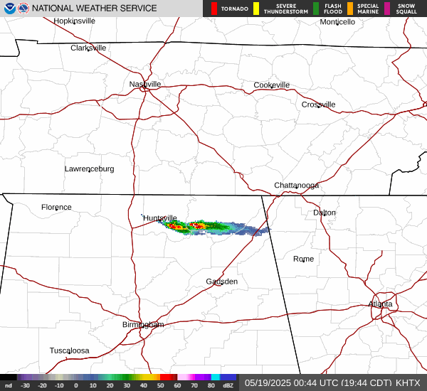
Here at 8:13 PM CDT we've got some rain moving through Southeastern Madison and Southern Jackson Counties in Northeast Alabama.


The main problems close to here are in Arkansas and Texas, where severe thunderstorm warnings are in effect this evening.


The real action is out in Oklahoma and Kansas, where I'm showing one of three tornado watch boxes above. Several supercells out there are producing large hail, damaging winds, and possible tornadoes.

Many of the tornadoes today have been confirmed already with reports in Oklahoma, Kansas, Nebraska, and even one in Colorado - 25 tornado reports so far today. And then you can also see on that map, we had those really damaging winds that brought down so many trees and power lines this morning in East Central Alabama. They issued a rare "Particularly Dangerous Situation" for that Severe Thunderstorm Warning, I recall. Or at least they used similar words so that it would wake people up via WEA on their cell phones. Usually you don't see that except with Tornado and Flood Warnings. And of course Amber Alerts. But once in a while you can get a random storm like that, that becomes pretty dangerous.

Looking at this evening's radiosonde sounding for Birmingham (from 7 PM CDT or OO UTC), the atmosphere is strongly unstable, a lot like it would be on a summer evening. If any storms were to initialize down there around the Shelby County Airport in this airmass, they'd carry a risk for large hail, and there is enough wind shear to support some damaging wind gusts. The threat of a tornado would be really low, and notice that even with a rare PDS tag on the Severe Thunderstorm Warning this morning as the storms came through the South side of Birmingham and tracked through that general area, nobody thought the storm was trying to produce a tornado. It's just that in some cases, the straight-line winds can become just about as dangerous. And they needed to let people know this was one of those rare times.

Meanwhile up at Nashville, or Old Hickory, instability is marginal at most this evening. And the wind shear is only marginally supportive of any stronger thunderstorms if anything were to move through there.
A lot of people have posted on social media that short-staffing at some National Weather Service offices may have diminished the quality of warnings the other day in Kentucky. I think it's too soon to verify whether or not that is true. But I hope somebody who is using his/her better sense will make sure that some checks and balances are observed with regard to these budget cuts that affect NOAA and the NWS. Because we do need this upper-air data twice a day, just as we need forecasters to be able to work overnight shifts and all the rest of it. If anything, we need more data and reliable employees in the National Weather Service, certainly not less. Anybody who worked to fill in the gaps, including Ryan Hall and his buddies who live there in Kentucky and do all the YouTube stuff, thank you! Right now we need people who care about what's important. And we all know what's important during a tornado outbreak like we had in those other states the other day. Anyway, that's why I've started posting these soundings. I used to take them for granted. And I paid more attention to forecast soundings, sometimes skipping over the actual observed soundings. But without these pieces of real-time data, the computer models couldn't crunch up all these complex equations to generate all the forecast soundings, not with any accuracy. I'm glad to see that our local offices in the Southeast are still doing them regularly. A few places around the country have stopped. And that does impact us all negatively, since it takes a few variables out of the equation. We've got less information to work with nationwide that way. But our local NWS offices have always been good at weathering the storms and making the best of whatever happens. And I'm glad to see that continuing. As John Gordon said on the latest episode of Weatherbrains, the best statistics for accuracy in issuing warnings and avoiding false alarms is in Birmingham, Alabama. And I've heard several people say over the years that it's a shame this doesn't get more publicity. You'd think all the other offices might want to follow their example. Maybe that will come with time.


Tomorrow it looks like we'll have partly to mostly cloudy skies, a High of about 85-86. The Low should be about 65-66. And I think we should keep a minimal 20% chance of an isolated shower or thunderstorm in the forecast.

It looks like another big severe weather day in other states tomorrow, with the hot spots being cities like Tulsa, Wichita, and Kansas City from this event. The chance of a thunderstorm reaching severe limits around here is not zero, but it is low.

Certainly the tornado threat is expected to stay well to our West and Northwest, mainly in that 10% hatched area you see across parts of Kansas, Oklahoma, Missouri, Arkansas, and Texas, also clipping Southeast Nebraska. Supercell thunderstorms are expected to fire out there, and some could produce tornadoes, just like today or like the other day when mainly Missouri and Kentucky were affected. The setup is similar enough, even if the probabilities were a little higher with the previous event.


Those supercells out that way could also produce the really large hail, think in terms of ball sizes instead of coin sizes. And of course there's also a threat of plain old damaging winds in some of the thunderstorms.
If we do get anything around here (threat is slightly enhanced for that in Northeast Alabama up into Middle Tennessee, latest model guidance showing, remnants of a mesoscale convective system could produce that), it'd probably be damaging wind gusts or the kind of hail that could be measured in coin sizes. That's the only severe weather that looks even marginally possible around here tomorrow.


Tuesday is the day to really watch as the cold front will start to finally push through the region. During the day, rain and storms should stay scattered around here, about a 40% chance, but then thunderstorms are likely at night. Initial storm mode will probably be supercells, which will later form into either some clusters (mesoscale convective systems) or a typical squall line (quasi-linear convective system). By the way, most people just spell that latter term QLCS. Looks like a High near 85, Low of about 68. I'm going by Model Output Statistics for the most part with this forecast, because the National Blend of Models text website appears to be FUBAR this evening. Any system can fail once in a while. I think the MOS guidance is really reasonable here anyway.


The NAM is showing a concerning blend of unstable air and wind shear between 4-7 PM when those supercell thunderstorms should start to initialize in the Southeast Region.

A forecast sounding at 7 PM (I clicked somewhere around Vinemont) shows strong instability, ample wind shear to support all hazards including tornadoes, and a Supercell Composite value of 11.5, a Significant Tornado Parameter in the 2-3 range.
So this spells mainly a threat for large hail (could be really large hail, like up to golfball-sized for some places), damaging winds, and tornadoes across the region. And like I say, some of the first storms will probably be isolated supercells. Those tend to do the most damage. Later when they form into clusters or a line, they are still dangerous, but one storm doesn't get to hog all the fuel the way it does in a discrete supercell.


The SREF ensemble shows a tamer atmosphere, as it usually does. But still it shows moderately unstable air with CAPE values at the surface in about the range of 1,000-1,500 j/kg. And the Helicity values at 3 km are up to about 200 units, which is what you'd look for to support a threat for tornadoes. It's sort of on the lower limit for that, but still . . .


And it's showing Lifted Indices more in the range of -1 to -3 around here at 10 PM Tuesday night.
Helicity values at 1 km are about up to 200 m^2/s^2 too. That's some pretty strong low-level rotation. You really only need a value of about 150 to support a tornado threat usually.


It's also showing dewpoints between about 65-70 degrees (really high for the Spring months, more what we see in summer). The bulk wind shear between 0-6 km is about 30-40 knots. So all of this points to a threat for organized severe weather.


The Supercell Composite numbers look surprisingly low when the SREF has the best chance of severe around here, so that makes me think this model expects us to have more of a squall line or cluster storm mode by this time. Which makes sense. The Significant Tornado Parameter value is still in the 1-2 range around here. So we'll have at least an isolated tornado threat. The tornado threat looked a little more significant via the NAM, but that's why I looked at the SREF. It tends to balance things out when the NAM screams major danger, if the threat isn't quite that extreme. And the other day, both of them made things look dangerous around here, both in Alabama and in Tennessee, and that was offset by not having much forcing around here, the parent Low being so far North and all that. This time we will have decent forcing/lift because of the cold front coming through. The Low is expected to be moving through Iowa though. So this is far from being an ideal severe weather setup. It is certainly enough to respect and take precautions for though.


We've only got about 12 days left in our usual severe weather season. But this threat is looking respectable. We're not to the point we can relax and say that summer is here yet.


Latest guidance makes Wednesday look sunny with a High near 80, Low of about 60 or so. High pressure strongly moving back into the region behind this cold front. This may be the last cold front passage we see in several months. It's one of the last anyway. We hardly ever get cold fronts passing through here in the summer time.


Cooler air starts to settle in here on Thursday with sunny skies and a High in the lower 70's, a morning Low in the mid-50's.


Another sunny day Friday, High of about 70 or so, the Low near 50 or perhaps dipping into the upper 40's. If you like this kind of weather, enjoy it while it lasts. Might be the last time for several months. It really would be a great stretch of days if you need to get something done outside that you've been putting off because it's been muggy and sometimes a little stormy or rainy lately.


Then next weekend, we'll have a couple of shortwave troughs move through upper-level Northwest wind flow. And some rain chances will come back. But here for Saturday it looks like about a 20-30% chance of any one spot getting a shower or thunderstorm. Looks like a High in the lower-to-mid-70's and a Low in the lower 50's for Saturday.


And then for Sunday it looks like a High closer to 80, Lows more in the mid-50's, rain chances staying minimal, about 20%. Which is about what we have most summer days. So we're gradually going to be moving toward that kind of a pattern. We're just not there yet. And hey, we need some time to ease into the hotter days. We don't get that every year. A lot of what's going on this year so far, I like. All the rain may help keep us from getting super hot even if we come under a strong ridge of high pressure later in the Summer months. And around here, we haven't had a ton of storm damage (knock on wood, don't want to jinx Tuesday) like they have in other states. And these patterns we've been in give us time to get used to the heat instead of it hitting all at once. That cool snap coming up late this week is a real treat.

Rainfall totals will average around one inch for most of us during this forecast period.
There's the link if you'd like to drop a dollar in the bucket and support these weather blogging efforts.
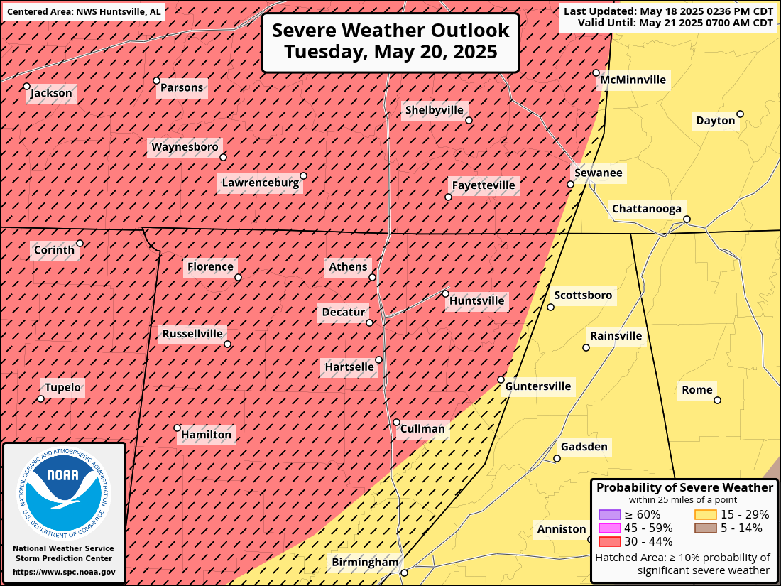
We really will have to watch Tuesday evening and night. Everybody around here but far Northeast Alabama and a few adjacent parts of Tennessee and over into Georgia is outlooked already for a threat of significant severe weather from supercell thunderstorms. Whether or not one ends up producing a tornado, even if the main threat is from large hail, this is a threat I'd respect. Oddly enough, this is falling on the birthday of the weather lady in my family, who's been gone more than 10 years now. But anybody can look at this and see that it needs to be taken seriously. At least keep an eye on it and see where things trend. And it's better to have your severe weather safety plan straight in your head before any storms start firing up. We've got a couple days to prepare, whatever ends up happening. Every event is different. The analogs mostly look like just general events that produced damaging winds, large hail, and a few tornadoes within what were probably squall lines. There are a couple of analogs that are more concerning, one in 1995 and one in 2004. So let's err on the side of caution. We're nearly done with our severe weather season, but we do need to respect this threat. Organized severe weather is likely for at least some parts of the Southeast/Tennessee Valley region. It's better to just respect that threat than to nitpick and try to figure out exactly what forms it will take. Having said that, if large hail does turn out to be the dominant storm mode after all, it'd be the kind of day to park your car under a parking deck if you've got one handy. I lost all the glass in a car in 2018 from a hailstorm, and the guy who fixed it told me it was brutal even compared to cars he'd seen bashed by baseball bats in Birmingham. Of course protecting life is more important than protecting property, but mentioning the property part too just in case some of us do get a bad hailstorm in this mix. There are some factors that could offset that risk, but I'm taking a play-it-safe approach for this system coming up.


No comments:
Post a Comment