

FORECAST:
Friday (High 86, Low 69): Warm and breezy with increasing clouds. Thunderstorms are likely late at night, and some may be severe.
Saturday (High 85, Low 68): Partly to mostly sunny and somewhat breezy. An isolated shower or storm is still possible during the morning.
Sunday (High 84, Low 67): Mostly cloudy. Numerous rounds of showers and thunderstorms are possible.
EXTENDED OUTLOOK:
Monday (High 86, Low 66): Partly cloudy with a 30% chance of showers/thunderstorms.
Tuesday (High 87, Low 67): Partly cloudy with a 30% chance of showers/thunderstorms.
Wednesday (High 84, Low 69): Mostly cloudy with a 40% chance of showers/thunderstorms.
Thursday (High 74, Low 58): Mostly sunny.
PRONÓSTICO:
Viernes (Máxima: 86, Mínima: 69): Cálido y ventoso con nubosidad creciente. Es probable que haya tormentas por la noche, algunas de las cuales podrían ser severas.
Sábado (Máxima: 85, Mínima: 68): Parcialmente o mayormente soleado con algo de viento. Aún es posible algún chubasco aislada durante la mañana.
Domingo (Máxima: 84, Mínima: 67): Mayormente nublado. Posibilidad de numerosas rondas de lluvias y tormentas.
PERSPECTIVA EXTENDIDA:
Lunes (Máxima: 86, Mínima: 66): Parcialmente nublado con un 30 % de probabilidad de lluvias/tormentas.
Martes (Máxima: 87, Mínima: 67): Parcialmente nublado con un 30 % de probabilidad de lluivas/tormentas eléctricas.
Miércoles (Máxima: 84, Mínima: 69): Mayormente nublado con un 40 % de probabilidad de lluvias/tormentas eléctricas.
Jueves (Máxima 74, Mínima 58): Mayormente soleado.
It is a good time to review your severe weather safety plan, just to be on the safe side with tomorrow night's event. Make sure the people you love know that a severe weather potential is coming (even if it's on the lower end for a lot of us), and since this will be overnight, it's best if you have a weather radio (with battery backup) or at the very least, Wireless Emergency Alerts enabled on a cell phone.
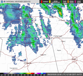


We do have some really light showers moving into the region this evening, and we have some thunderstorms throughout the Mid-South ahead of a cold front that extends through Arkansas and Missouri.


And there is enough turning of the winds even at the lowest kilometer of the atmosphere to support a tornado threat. This helicity is ample for that.


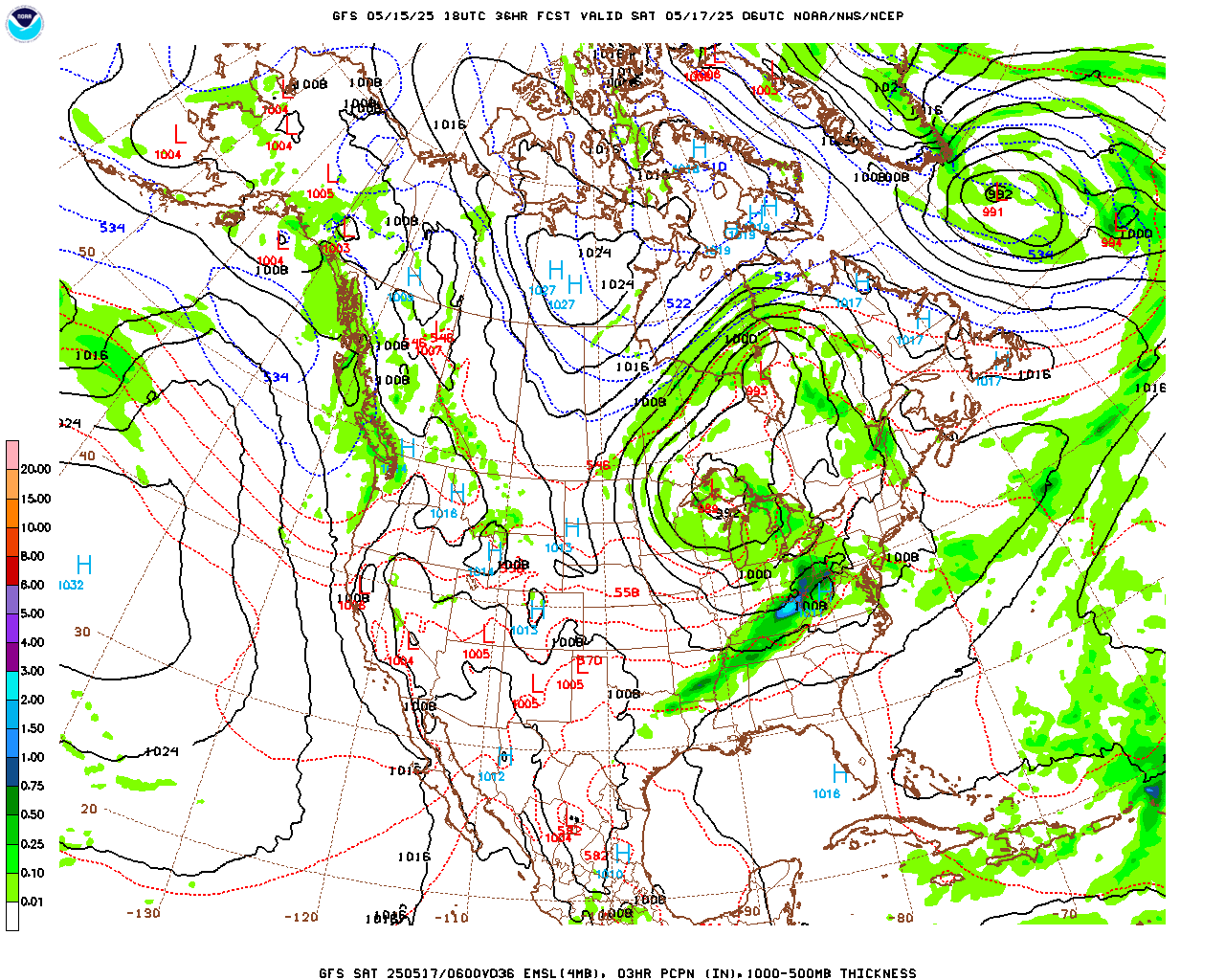
The ECMWF does show a fair coverage of rain, and it's probably closer to being right. But I'm still capping the rain chance at 50% for Sunday. Highs should be in the lower to mid-80's, Lows in the mid-to-upper-60's.


Some weather radio transmitters (including Winfield) that are served by the National Weather Service in Birmingham will be offline for a few days next week while they make some necessary updates to some of their technological systems.
The National Weather Service in Nashville is still doing Weather101 classes, though I've lost track of them lately. The next one is on weather forecast models, and if you've never taken one of these online classes, I'd strongly encourage you to try one. A lot of them are great.
John Gordon is said to have given some good advice to up-and-coming meteorologists on the latest episode of Weatherbrains. Who knows, maybe I could have succeeded in the field if I'd had access to such nuggets of wisdom back when it still mattered . . . I'll have to listen to the full show at some point. I caught five or ten minutes of it live the night it aired I think. And he really is a good one. I suspect he'll be helping the broadcast folks in Kentucky with tomorrow's severe weather, as he's done before. I know some people who live up there, and I'm very glad they've got him. They had him at the National Weather Service until recently, and now the broadcasters have (wisely) snatched him up to help them get the word out when the weather turns high-impact.
As usual, if anybody finds mistakes in the Spanish translation, let me know. Which most people don't care about anyway. But I think I remember hearing from a Hispanic reader or two. And I'm having to resell some used books by one of my favorite magicians, Juan Tamariz, whose books I hope to read in the original language some day. Seriously, anybody who likes magic or is intrigued by the Spanish language, look him up on YouTube. His skill with cards is amazing, and he has a unique style/sense of humor.
But that's my excuse for being the odd man out who does sort of care about being bilingual, when I know a lot of my peers take the attitude expressed by a fast food manager I had once. When I told her I knew a little of the language, she asked me how to say, "Go back whur ye' came from."
I don't think anybody who eats at Taco Bell, much less any of the nicer such restaurants, has any right to throw such an attitude around. But that's why I'm not popular and never will be. And to end this ramble, I'll only add the sage words of a guy a woman in my family used to date who was Mexican and lived in Colorado, where they too have a lot of severe/interesting weather. He said if Mexican food tears your stomach up, you're worrying too much.
So if nothing else, those delicious burritos, quesadillas, and such like are a good barometer of if you're managing your stress level well. If it gives you the trots, you need to calm down. (The drinking water in Mexico is a whole different story. I'd take Weird Al's advice and just plain don't drink it.)
This is some kind of mental health awareness month, and I saw where James Spann retweeted some idiots sending him messages accusing him of being in some big conspiracy because he'd referred to the Gulf of Mexico instead of updating it to the Gulf of America (think he said he's just gonna' call it the Gulf, which sounds good to me). And with his typical classy understatement, he said that we had a real mental health crisis in this country these days.
I'm admittedly a part of that, as my stomach has been extremely grouchy lately, grouchier than that fast food manager who had such heartwarming, progressive views on immigration and learning to live together with a variety of cultures. So I'm eating lots of burritos and daring it to do its worst.
Uh . . . don't try that at home. Actually . . . don't try that in public. It's easier to get to a bathroom at home.
Three guesses why I never wound up in broadcast meteorology . . . making big bucks and beloved by all great American heroes and all that jazz.
Anyway, I hope most reasonable folks have skipped to the forecast discussion by now. If you've read all this, you might want to go for a mental health assessment yourself. Unfortunately I think they do cost something. Nothing's free (or cheap) these days, not even water that'll tear your stomach up.
Well, there is one thing that remains cheap: people's big talk. Talk is still cheap. And so are most of the things I hear people talking about - cheap and petty. Life goes on. The weather keeps changing. And the power bill is only cheap if you are not overly concerned with staying cool.
* Readers are advised to skip aimless rants such as ye' might find below . . . *
And by the way, as much as I love James Spann and John Gordon, I call bullshit on James's claim to occasionally say outrageous things in the pre-show (of "Weatherbrains"). Once in a while, they do make good jokes, or say things that are unpopular and need to be said. But "outrageous"? No. Not even close. The people on that show know where their bread is buttered and keep things in zones that they know are safe. Some of the stuff I say on this blog really does border on the outrageous, and I just try to keep it well-behaved enough that nobody literally wants to try to come after me and stab me to death. Most meteorologists with a higher public profile, including those on Weatherbrains, only say about 10% of what they may be privately thinking. One of the folks in the NWS who used to be among the more outspoken told me privately that they can't talk about the budget cuts publicly. As in, they have orders not to. (This person will not be identified. Not joking about that.) And for those who remember Al Moller, the reason he never got promoted to the positions he deserved was that he called things the way he really saw them. He offended a lot of the wrong people, and they didn't promote him. I've heard that from several reliable sources over the years. If anybody on that (Weatherbrains) podcast were to dare to be as honest as he was, they'd face serious problems. And that's why they keep it PG-rated, even at its most "outrageous". I wish there really was a forum for people in meteorology to tell the uncensored truth, but I don't think that exists at all now. Even this blog is not a good place for it. Some people might think I'm different, that I'm just speaking my mind sometimes with no filters. But actually, I watch myself in certain ways too. I just live in an environment these days that is not nearly as privileged, with as many social niceties, as these people who work in meteorology for a living. Or who are still in college. So sometimes I get disgusted with being too polite, to the point of ignoring some of the ugly truths that everybody really knows are right in front of all our faces. It's tough to go back to bullshitting and painting pictures of rainbows when the real world every day is the exact opposite of a nation of philosophers, or anything close to people living in ivory towers. So . . . sometimes I say more-or-less what I really think. And when I do, I remember why these people who do live such privileged lives have to keep their mouths shut, to maintain their positions of great privilege. There are some consequences to being outspoken, even for lowly people like me, that hardly anyone really cares about.
So I'm curious to see if that was part of John Gordon's advice. He should have mentioned that there is indeed some value in keeping one's honest opinions to oneself, if not downright brown-nosing and bullshitting. The key is to learn how to slip a smidgen of a smackerel of honesty in there once in a while. Hiding behind a "positive attitude" is advisable, even if privately it makes the hider feel more like jumping off a bridge.
* It's safe to come out of shelter from ranting and raving now. *
DISCUSSION:
At 6 PM latest observations showed fair skies in Cullman with a temperature of 81 degrees. The dewpoint is 70, making the relative humidity 70%. Winds are out of the Southwest at 7 miles per hour. The pressure is 29.90 inches and holding fairly steady, has fallen slowly at times through the day. Visibility is 10 miles.
The High today was 84, and the Low was 66. Jasper saw a High of 88 and Low of 64. Haleyville had a High of 86 and Low of 65. Huntsville has become overcast this evening, High of 87 and Low of 68 there. Nashville also has some clouds moving in this evening and had a High of 85, Low of 70 degrees today.


The main severe weather threat with this widespread system is up around the Great Lakes. Any of the storms in the Tennessee Valley becoming severe tonight is very low, even on the Tennessee side of the AL/TN state line.

We have a better chance of seeing a few storms reach severe limits tomorrow (we're only halfway through May, so we're still in our primary severe weather season), even though the best chance looks to be in the Northern half of Tennessee up into Kentucky, clipping the Missouri Bootheel and Illinois/Indiana. That's going to be a close call, who ends up getting the best chance of severe thunderstorms tomorrow. Overall I think the threat for North Alabama/Southern Middle Tennessee (at least the bordering counties) will stay on the lower end.


Most of the day tomorrow looks dry. Clouds will just be increasing during the day, winds picking up, could see gusts up to about 20 mph out of the South. Our High should be about 85-86 with a morning Low of about 68-69.
It looks like we'll get a line or maybe a cluster or two of storms as we get close to the Midnight hour. And those will have to be watched for severe potential.

And that Energy Helicity Index actually does look concerning late tomorrow night/very early Saturday morning (like around 1 AM or so). So let's take a forecast sounding or two and look at the details.
This data is from the North American Mesoscale model.

For that bullseye Southwest of Nashville where the EHI is maxed out at a value of 7, this is not what you want to see, looking like an almost ideal setup for a tornado to develop, one that's capable of a good bit of damage. I'm going to double-check this against some other models since the NAM can sometimes get carried away and make things look scarier than they are really going to be. But this is showing a powder keg of high instability and really strong wind shear, including the kind that would produce tornadoes. It's actually showing a Significant Tornado Parameter of 10 and a Supercell Composite value of 30 in that zone, which is not something you want to see. It's relatively rare to see that, and it'd be more along the lines of the risk we saw back on March 15 earlier this year. If this one model's output was all there was to the story. I have to say, I did not expect to check the parameters and see them looking this bad. I'm skeptical of it, but before we move on to some other models, let's look at how things look down around Smith Lake, Cullman/Winston/Walker Counties.

And while this isn't as full-blown, you really don't want to see this either. I am already regretting the dismissive tone I took at the beginning toward the severe potential tomorrow night. It's definitely worth examining.
Instability looks to be moderate to high even though it's around Midnight. (This forecast sounding is technically valid at 1 AM going into Saturday morning.) The wind shear/helicity and curved hodographs and everything show a favorable environment for supercell thunderstorms to develop that would pose a threat for damaging winds, large hail, and tornadoes. Down here, our STP value is more like 3-4, which is better than 10, but still, that usually indicates a fairly significant threat for tornadoes.
And that's why I'm going to look at some other models before deciding how to forecast this. I did not expect to find this, and it would surprise me if all the other models were on board with it.


Unfortunately between 10 PM tomorrow night and 1 AM Sunday the SREF is showing STP values getting up to 6 in North Alabama and Southern Middle Tennessee.


And this continues to look concerning. Dewpoints are forecast to get up to 65-70 degrees. Bulk shear between 0-6 kilometers is forecast to be about 50 knots. And this is from the SREF, which usually is the calm, balanced ensemble when the NAM gets carried away with severe parameters.


It's looking like strong instability, CAPE values near 2,000 joules/kilogram, which you rarely see at this late an hour of the night. And when you do, you can see some powerful storms.


And since the HRRR is showing STP values in the 3-6 range too at this same time frame, this has definitely gotten my attention, even though I'd planned on blowing it off, when I started this forecast discussion. This has the potential to be a fairly serious severe weather setup, and for West/Northwest Tennessee up into Kentucky, it could get really serious, the way this is looking.
Since I've been out of the weather loop in general lately, I'm going to take a few minutes to read over some forecast discussions by forecasters that I consider reliable before continuing. This was a bit of a surprise. I guess it's true what Alan Moller always said, that you have to expect the unexpected. We've had a lot of lesser severe thunderstorm threats that didn't do a whole lot of damage lately. And I guess this is a good reminder not to become complacent. Having said that, something doesn't feel right about this to me. And if some human forecasters also feel like this model guidance is "off", then I'll feel better about trusting my hunch. And maybe at least one or two of them can give some scientific reasoning to back up why the models might be overdoing this setup.
It does look like supercells will be forming in Southeast Missouri/nearly parts of Arkansas and spreading into the Ohio Valley (mainly Kentucky) into Northwest Tennessee tomorrow afternoon/evening. Those will be the main storms to watch during the peak heating hours. And of course when they are isolated like that, they can become more damaging since they hog all the fuel in the atmosphere.
Some supercells could still be going on by the time the storms get into at least Northwest Alabama and Middle Tennessee, which would be around 8-10 PM, is a good estimate. But it's more likely that by about 10 PM the storms will have formed into either a squall line or some less organized clusters that we call Mesoscale Convective Systems.
This is a sort of odd setup where we've got a mix of Spring and Summer elements coming together. And when we had another odd summerlike setup (but with other parameters favorable for severe storms) in early April, we did have several tornadoes, mainly in Western and Middle Tennessee and of course back in Arkansas. It's also worth remembering that we had an awful lot of scary-looking overnight Tornado Warnings that hit Central Tennessee/Southern Tennessee, including some that included the city of Nashville, which produced little or in some cases no actual damage. A lot of those rotations, bad as they looked on radar, did not make it to the ground. It really takes a perfect balance to get significant severe weather, and that's something to keep in mind too. A lot of times these setups that look really threatening via model data end up underperforming or even "busting" because things are just "out of phase" as I've often heard one forecaster put it. The right ingredients don't end up being there together in real time after all. And in those cases, we do have a severe weather threat. Sometimes one or two places even gets significant damage out of an event like that. But it doesn't look as apocalyptic as some people could blow it up and make it out to be, just taking the model guidance at face value and yelling that the sky is falling.
If we did get a really significant severe weather setup out of this, it would be unusual. Our pattern lately has been trending more toward a summer setup than the setups we see through March and April, the really volatile stuff. But . . . can't ignore this model guidance. They are just about all picking up on this basic idea, that we'll have a threat for severe thunderstorms and even tornadoes out of this overnight event. And some of the data suggests that significant impacts are possible.
One thing the National Weather Service in Nashville is pointing out is that the atmosphere is likely to stay capped long enough to prevent much in the way of discrete supercells in Middle Tennessee. Unfortunately, if even one or two such cells do form, they are thinking, much as I have (reluctantly) been, someone could get a really damaging storm. And this environment could certainly produce a tornado. So it's really a matter of whether the strongly unstable air around it can erode/break this capping inversion at about 700 millibars. If it does, somebody could be in for a nasty surprise.

The main tornado threat outlined by the Storm Prediction Center is over Kentucky, clipping Southern Illinois/Indiana, also clipping the Missouri Bootheel and far North/Northwest Tennessee.
A more general isolated tornado threat is forecast for most the rest of Tennessee, barely clips far Northwest Alabama. And as you get down into North Alabama, they are showing a minimal chance of an isolated tornado.
My personal opinion is that because of capping likely to be in place ahead of the main squall line (or MCS if it's more of a cluster/clusters thing that the supercells finally form into tomorrow evening/night) and the best forcing being displaced away from our region (the surface Low being way, WAY up North for this one), these storms are going to struggle as they move through Middle Tennessee/North Alabama. But we have enough unstable air and wind shear in place in some fairly threatening combinations. So if that capping can be overcome, especially if it happens anywhere before the actual squall line (or storm cluster) where even one storm can become discrete, somewhere in our region could see a significantly damaging episode of severe weather here. And it could very well be a tornado. A lot of times meteorologists say that it "only takes one" to make it a significant event, and that's how I'm looking at this one. It's more likely that we'd see damaging winds, large hail, or a tornado try to spin up in a squall line. But we can't totally write off the threat of an isolated supercell or two, especially on the Tennessee side. People in West Tennessee, definitely be on guard for that. Even though that threat is low, if anything could develop in that way and sustain, the impacts could be significant for whoever gets hit. So this is one of those conditional, complex setups.


The threat for really large hail (like golfball sized) should mainly be over the Mid-South and Ohio River Valley regions. The really severe winds (hurricane force possibly, like 75 mph or above) are outlined to happen mainly over the Northern 2/3 of Tennessee up into much the rest of the OH Valley. Kentucky, especially Western Kentucky, looks to get the worst of this severe weather setup in every way.
Once again I'll throw in the caveat that these same really significant hazards could happen with any discrete supercell thunderstorm, even down this way, where our threat for damaging winds/hail (or from that earlier graphic, a tornado) are more on the basic or low end of the spectrum. But remember, that 10% hatched tornado threat was mainly centered over Western Kentucky. They could see some significant tornado damage out of this event. The potential is there.
And to think I started this discussion with the intent not to hype anything at all, and to downplay any hype that might be going around.


Will only keep a 20% chance of rain in there for Saturday, most rain should end in the morning hours, staying kind of breezy, High in mid-80's, Low in upper 60's.


And because the upper-level pattern has already become more summerlike where it's hard for fronts to pass through the region, things are going to more-or-less stall out. The GFS doesn't show much rain around Sunday.


Monday it looks like a 30% rain chance is reasonable. Highs could climb into the upper 80's.


Will hold that same chance for Tuesday as a low pressure system approaches. Highs in upper 80's, Lows in mid/upper 60's.


The GFS shows the front blowing through here quickly on Wednesday.


The ECMWF is less enthusiastic, which is how things usually go. But the timing difference is not all that great. The European is just a little slower than the American model here.
It really looks like Tuesday night into Wednesday could feature another threat for stronger storms.

But looking at SPC's guidance for that time period, looks like anything organized will stay out in mainly Missouri and Arkansas.
We'll get the leftovers, which sometimes are under severe limits in setups like this, this time of year.
And this is an unsettled, uncertain pattern in general.
Will bring rain chance back up to 40% for Wednesday, but most of it should be in the early part of the day. High should be in lower 80's, Low in upper 60's.


Then for next Thursday, mostly sunny skies, High dropping to the lower/maybe mid-70's, Low in the upper 50's. We won't have many shots of cooler air like this for a while. Summer looms.
It has been a long time since I've felt as stumped by a weather forecast as this one. It reminds me of one particular snow setup I couldn't make heads or tails of up until the time it actually played out, when I was in college. So I'm going to defer to the experts. You've read my speculations above.

For places like Cullman, Jasper, Double Springs, the severe weather risk tomorrow night is a Level 1 Marginal Risk, the lowest they issue. Something isolated could become severe.
For places like Hamilton, Hartselle, Florence, up to Athens and Huntsville, also Fayetteville back to Lawrenceburg, the risk level is the basic Level 2 Slight Risk. Several thunderstorms within this zone could become severe, but those storms will probably be scattered throughout a squall line where not all of the storms are damaging.
Points North of there in Tennessee, like North of Waynesboro and Shelbyville have a Level 3 Enhanced Risk for severe weather tomorrow night into early Saturday morning. Numerous storms in this zone may become severe. The coverage of severe weather is expected to be more widespread than in the lower-risk zones. If you get a storm in this zone, the chance of it becoming severe is pretty decent.

The main threat is damaging winds, and the core of that threat looks to include places like Huntsville, Decatur, Athens, Hartselle, back to Florence down to Hamilton, also including Lawrenceburg and Fayetteville in Tennessee. The greater damaging wind threat (notice the hatching) looks to be generally in the Northern half of Tennessee, so really doesn't affect us down here. Most of us have the basic 15% threat.
And really down in Cullman, Jasper, Guntersville, Arab, Joppa, up to Rainsville, it's more of a marginal 5% risk outlined.

With hail, again the really significant threat is well to our North (and West in this case). A basic 15% threat for large hail does include all the Tennessee counties near here and places like Athens, Florence, and Russellville, Muscle Shoals. But most of us only have a 5% marginal threat for large hail.

And for the most part, on the Alabama side, we only have the marginal 2% isolated tornado threat. On the Tennessee side, at least the areas people would be likely to read this blog from, it's still just a general 5% isolated tornado threat, which is pretty standard. Get down as far South as Cullman, and SPC has no tornado risk defined at all.
The only caveat I'll add is that if the capping of the atmosphere were to break earlier than expected, even if we got one or two supercells out of this event, then these hazards could become greater locally for those impacted. Maybe that always goes without saying, but I felt like I should emphasize it in this setup. There's just an outside chance of someone in our vicinity getting a more significant severe weather episode. I think of how in Nashville and East of Nashville in 2020, those tornadoes happened in the areas outlooked for barely any severe weather instead of in the places expected to be more the hot zones. I could see that happening here, but that's getting back into my personal speculations, when I have to admit I'm a lot less qualified than the people drawing these maps, plus I've not been keeping up with the weather regularly lately. I haven't had the time or energy much until this evening.
Usually with a setup like this, the storms weaken as they move into our area. But a lot of that model guidance did concern me. And I'd still take good precautions as a course of least regret.

Rainfall totals for this forecast period should average about an inch on the Alabama side, more like two inches on the Tennessee side.
^ For anybody who actually gives a damn about this blog and wants to throw a dollar in my bucket.
CHATTER:
I've got a neighbor who managed to let two of her female cats get knocked up before she could get them spayed. This seems to have been the doing of one particularly feisty tomcat who roams the area. We've got eight kittens out of this misfortune. And it's only a misfortune because they don't have homes to go to.


They are rather adorable (see Figures 1 through 4 - Feline Editions).
Get in touch with me if you'd like to adopt one. And I'll get you in touch with the lady needing to give away these cats. Her only concern is that they get a good, loving home. She's not going to give them to somebody she thinks won't treat them right.
The level of personal turmoil I've had lately is more than I care to share online. I'll simply say that I'm glad someone in my family tree is still alive, though injured, and that so is her friend. It could have been a lot worse. But that was the main thing that knocked the wind out of my sails lately. It's sort of like if somebody you knew got hit by a tornado and survived with very manageable injuries, when I think about it . . .
Anyway, stay safe from the weather if it does get out of hand tomorrow night. Summer is almost here. And then usually you're okay from the heat unless, as an old grouch in my family liked to put it, "yer styooooopid an' stay out in it!"
P.S. Just in case anyone ever wondered, what you read here is in the opposite order it's written in.
The discussion at the bottom is written first, and then I go back up and write the forecast that's up top. And often I fill in the notes last. So with that in mind, it's not as haphazard as it may first appear. A wild ramble may appear before the scientific details, but it was actually written after them.


No comments:
Post a Comment