FORECAST:
Sunday (High 80, Low 62): Mostly cloudy with numerous rounds of showers and thunderstorms possible throughout the day. Some storms may produce damaging wind gusts or large hail.
Memorial Day (High 80, Low 64): Rain and thunderstorms likely. A few storms could become strong.
Tuesday (High 79, Low 66): Rain showers likely. Thunderstorms possible.
EXTENDED OUTLOOK:
Wednesday (High 80, Low 65): Mostly cloudy with a 50% chance of showers/thunderstorms.
Thursday (High 81, Low 64): Partly to mostly cloudy with a 40% chance of showers/thunderstorms.
Friday (High 78, Low 63): Mostly cloudy with a 40% chance of showers/thunderstorms.
Saturday (High 79, Low 58): Partly to mostly sunny with a 20% chance of showers.
BEACH FORECAST:
Sunday (High 88, Low 75): Mostly sunny with an isolated shower or thunderstorm possible.
Memorial Day (High 88, Low 75): Mostly sunny.
Tuesday (High 88, Low 75): Partly cloudy with widely scattered showers and thunderstorms possible.
Wednesday through Saturday (Highs in the mid-to-upper-80's, Lows in the lower 70's): Partly cloudy with a 40% chance of showers/thunderstorms.
PRONÓSTICO:
Domingo (Máxima 80, Mínima 62): Mayormente nublado con numerosas lluvias y tormentas posibles durante el día. Algunas tormentas podrían producir ráfagas de viento dañinas o granizo grande.
Día de los Caídos (Máxima 80, Mínima 64): Probabilidad de lluvia y tormentas. Algunas tormentas podrían intensificarse.
Martes (Máxima 79, Mínima 66): Probabilidad de lluvias y tormentas. Posibles tormentas.
PERSPECTIVA EXTENDIDA:
Miércoles (Máxima 80, Mínima 65): Mayormente nublado con un 50% de probabilidad de lluvias/tormentas.
Jueves (Máxima 81, Mínima 64): Parcialmente nublado con un 40% de probabilidad de lluvias/tormentas.
Viernes (Máxima 78, Mínima 63): Mayormente nublado con un 40% de probabilidad de lluvias/tormentas.
Sábado (Máxima 79, Mínima 58): Parcialmente a mayormente soleado con un 20 % de probabilidad de lluvias.
PRONÓSTICO DE LA PLAYA:
Domingo (Máxima 88, Mínima 75): Mayormente soleado con posibilidad de lluvias o tormentas aisladas.
Día de los Caídos (Máxima 88, Mínima 75): Mayormente soleado.
Martes (Máxima 88, Mínima 75): Parcialmente nublado con posibilidad de lluvias y tormentas aisladas.
Miércoles a Sábado (Máximas entre 85 y 88, Mínimas entre 70 y 73): Parcialmente nublado con un 40 % de probabilidad de lluvias o tormentas.
NOTE:
Here are the latest storm surveys by the National Weather Service in Huntsville for the May 20 event, which includes 13 tornado tracks so far across the 14 counties they serve.

We've got some strong thunderstorms moving through Lawrence and Morgan Counties at 4:30 PM CDT, affecting places like Mt. Hope and Trinity. Wind gusts up to 50 miles per hour and hail up to about penny size are possible with these storms as they move through, which is a little under severe criteria.
It has been a mostly overcast day in Cullman, and we have had periods of thunderstorms as well as just periods of light rain. I was going to give the Highs and Lows for today, but it's one of those messy setups where those are hard to ascertain at this time of evening. So right now we are overcast. The temperature is 68 degrees. The dewpoint is 66 degrees, which makes the relative humidity 94%. Winds are out of the Southeast at 6 miles per hour. The pressure is 30.11 inches and falling slowly. The visibilit is 10 miles. The Low this morning was 57.
By contrast, it is sunny and 73 degrees in Jasper. The dewpoint is 64, making the relative humidity 74%. Winds are East at 7 mph. The pressure is 30.10 inches and steady for the moment. Visibility is 10 miles. The Low this morning was 59.
Haleyville has a thunderstorm just to their East. The temperature is 69 degrees. The dewpoint is 66, making the relative humidity 90%. Winds are Southeast at 7 mph. The pressure is 30.11 inches/995.5 millibars and falling. (Always glad they provide the reading in millibars at the home of the 911 system.) Visibility is 10 miles. The Low was 58.
It is overcast in Huntsville with a temperature of 67 degrees. The dewpoint is 63, making the relative humidity 87%. Winds are Southeast at 5 mph. The pressure is 30.10 inches/1018.9 millibars and falling slowly. The visibility is 10 miles. The Low this morning was 60.
It is mostly cloudy and 70 degrees in Nashville. The dewpoint is 58, making the relative humidity 66%. Winds are out of the South, blowing the flies in the fishes' mouth at 6 miles per hour. The pressure is 30.11 inches/1019.3 millibars and falling. Visibility is 10 miles. The Low this morning was 59.
I noticed a discrepancy above, where both Haleyville and Nashville had a pressure reading of 30.11 inches, but Haleyville had 995.5 millibars reported, which sounds too low, and Nashville had 1019.3 millibars reported. Using the National Weather Service's handy conversion tool, it looks like 30.11 inches of mercury would actually be equivalent to 1019.64 millibars. So take that for what it's worth.

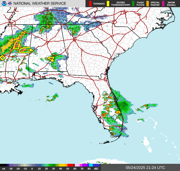


The severe stuff is widely scattered and back in Mississippi or far Southern Alabama, nothing like that in our neck of the woods. And these are closer to being those "pulse" type storms we get in summer but with a little bit of the dynamics of spring, with that warm front lifting northward and trying to stall out down around Montgomery. That pattern of storm clusters moving from Northwest to Southeast like we've had today, stuff coming our way from out West, is what's called an MCS setup - Mesoscale Convective System. We see those fairly often in the summer months, at least some years we do.

The morning sounding from Birmingham showed stable air and pretty strong wind shear.

Then if you look at Nashville, at 7 AM CDT they had really stable air and only marginal wind shear to support any stronger storms that might develop.


Tomorrow looks pretty similar, that classic MCS setup.


And the Storm Prediction has outlooked all of us in North Alabama/Southern Middle Tennessee (at least the bordering counties) for a Level 2/5 Slight Risk of severe thunderstorms capable of damaging wind gusts and some severe hail.
But it's going to be a lot like today, only difference is it may get warmer, likely will. The High should get up to about 80 degrees, morning Low about 60 or so. And the chance of rain is 50%.


Then rain and thunderstorms are likely for Monday, which is Memorial Day, when I remember a guy I had Driver's Ed with named Richard who never came back from the Middle East alive.


By then, the threat of stronger storms is looking marginal and generally confined to along and South of of the TN River. Should see a High of 80 or 81, Low in the mid-60's.
The GFS graphics are coming in slowly beyond this point, so I'll illustrate with standard weather maps from the Weather Prediction Center. This forecast package is not exactly rocket science, just has its nuances.

Rain and thunderstorms are likely again on Tuesday as the low pressure system and associated front lift North of Memphis. And that will spell another rainy day with some thunder in the mix, a High near 80 (maybe about 79 due to so much rain), Low in the mid-60's.

The front does get moving on Wednesday, but our weather remains basically the same, a High near 80, Low near 65, will trim the rain chance back to 50%. But a lot of us are still in for a decent soaking for at least part of the day.


Friday looks like when we get our frontal passage finally. We should see a High in the upper 70's, a Low in the lower 60's. And the rain chance will hold at 40%.

Then for next Saturday, we are likely to finally see more sunshine than clouds again, rain chance dropping back to 20% as the moisture behind this front starts to ease out of the region. The High should be in the upper 70's or near 80, the Low in the upper 50's.
And by the way, that will be the last day of May.


The risk of flash flooding continues to look on the low end, but many of us could see up to 3-4 inches of rainfall totals for this forecast period, over this next week.
No comments:
Post a Comment