


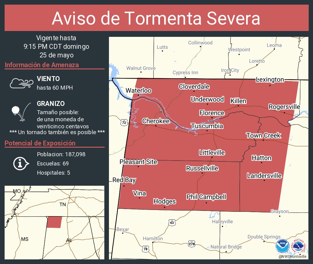
This is for wind gusts to 60 mph and quarter-sized hail, with a note that weak rotation is showing up in this line of storms from time to time.
8:17 - Here's a more detailed look at the new warning polygon that includes Western Lawrence County.
People from Tuscumbia down to Russellville, Phil Campbell, Mount Hope need to be in a good safe place while these storms pass - at least staying inside and away from windows.
It's really better if you can get to a small interior room (or at least a hallway - room without windows) on the lowest floor of a sturdy house rather than a mobile home. Especially if you've got trees around, if one falls, it usually won't come all the way through a sturdy-built house, and especially in a room where the walls are closer together, like a hallway.

8:23 - While there is a very low risk of an isolated tornado somewhere with these storms, this atmospheric setup strongly favors damaging straight-line winds and large hail instead of low-level rotation. That doesn't mean it doesn't need to be taken seriously. But trying to give you an idea of what to expect.
These are most likely "only" the kinds of storms that can damage or completely take down some trees and power lines and put down some large hail while they come through. We're probably not going to see much in the way of structural damage tonight except if a tree comes down on a home.
Then again, never say never. Once in a while a window does blow out from these kinds of winds. And sometimes a mobile home can sustain damage from 60-70 mph gusts even without trees around. So this is not as serious as what we had the other day, May 20, or back on March 15 earlier this season. But just a reminder that any severe weather threat is worth treating with some respect.
8:28 I'm tuned in to 101.5 FM WJLX in Jasper, since Coyote J. Calhoun is doing his weekly "Cemetery of Rock" show. It's too bad he can only play stuff before the year 2000, since he used to be known for mixing in some cutting-edge new stuff too. But he still picks great music and does hilarious commentary every hour or so. Curious to see what severe weather coverage they offer, if any, once the storms get to Walker County. I sure do miss the guy who managed that station, Brett Elmore, whenever I think about him. Seemed like a really cool dude. His friends called him "Big Sexy Elmo". Takes a special kinda' guy to get a nickname like that.
The best I've got for my pudginess these days is "dirty fat boy".
Coyote J. actually said Jerry Tracey told him one time not to mix humor with weather. Maybe that's what is holding this blog back from success. I crack too many jokes along with telling people about the serious stuff.

8:32 - On a serious note again, the storms are getting pretty close to Haleyville there over the Winston County line.
Used to know a guy whose mother lived there, we'd go up there and do laundry sometimes and all have some good chats. I didn't know until then that it was where the 911 system started. Anyway always keep them in mind when the weather turns rowdy.
And they just went under a warning, which once again, my weather radio did NOT tone for. It is probably time to invest in a new device, before this summer is over. I'd had this same one for over 15 years, and it has taken some really hard knocks. I certainly hope it's my device and not a problem with the communications network tonight.
Going to start a new post for the Winston County warning.
Severe Thunderstorm Warning
ALC033-059-077-079-260215-
/O.NEW.KHUN.SV.W.0147.250526T0112Z-250526T0215Z/
BULLETIN - IMMEDIATE BROADCAST REQUESTED
Severe Thunderstorm Warning
National Weather Service Huntsville AL
812 PM CDT Sun May 25 2025
The National Weather Service in Huntsville Alabama has issued a
* Severe Thunderstorm Warning for...
Lauderdale County in northwestern Alabama...
Colbert County in northwestern Alabama...
Franklin County in northwestern Alabama...
Western Lawrence County in northwestern Alabama...
* Until 915 PM CDT.
* At 812 PM CDT, severe thunderstorms were located along a line
extending from 9 miles southeast of Walnut Grove to 8 miles east of
Tishomingo State Park to near Fulton, moving southeast at 35 mph.
HAZARD...60 mph wind gusts and quarter size hail.
SOURCE...Radar indicated.
IMPACT...Hail damage to vehicles is expected. Expect wind damage
to roofs, siding, and trees.
* Locations impacted include...
Posey Loop, Mt Hope, Atwood, Florence, Ne Smith, Oakland, Waterloo,
North Courtland, Lexington, and Tuscumbia.
PRECAUTIONARY/PREPAREDNESS ACTIONS...
Remain alert for a possible tornado! Tornadoes can develop quickly
from severe thunderstorms. If you spot a tornado go at once into the
basement or small central room in a sturdy structure.
For your protection move to an interior room on the lowest floor of a
building.
&&
LAT...LON 3489 8810 3501 8807 3500 8741 3499 8722
3479 8725 3478 8728 3476 8726 3430 8733
3432 8817
TIME...MOT...LOC 0112Z 296DEG 30KT 3493 8796 3461 8803 3426 8833
TORNADO...POSSIBLE
HAIL THREAT...RADAR INDICATED
MAX HAIL SIZE...1.00 IN
WIND THREAT...RADAR INDICATED
MAX WIND GUST...60 MPH
$$
KTW


No comments:
Post a Comment