


And this one actually does include parts of Northern Walker County, places like Nauvoo and Curry. It includes nearly all of Winston County - places like Haleyville down to Lynn and Natural Bridge over to Double Springs, and in the Eastern parts of the county, Addison and Arley.
People down in Eldridge also need to be in a good safe place while these damaging winds in these storms blow through.

8:40 - And here's the broader view. You can actually see where there are some thunderstorms moving through Cullman County that are below severe limits - affecting places like Dodge City and Hanceville mainly.

8:44 - Here's a radar shot for folks in Cullman County who want to get ready for these storms. Can see where they are. In relation to where you are on the map. If you don't know what county or town you are in on the map, then definitely put that on the list of things to learn. It's amazing how many people don't know. I actually had a guy (in Marshall County, Arab) tell me one time: Why would you want to know what county you're in? And that is dead wrong. You need to know that and at least one or two surrounding counties. At least know the county directly to your West. Which if you're in Cullman County, is Winston County.
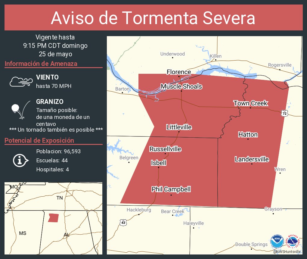
8:56 - Just a reminder that from The Shoals to Phil Campbell to Town Creek, that northern end of the storms, 70 mph wind gusts are expected.
9 PM - And we just got a new warning that includes Decatur . . . well you know what . . . it includes Vinemont in Cullman County so going to start a new post for it.
121
WUUS54 KBMX 260133
SVRBMX
ALC127-133-260230-
/O.NEW.KBMX.SV.W.0165.250526T0133Z-250526T0230Z/
BULLETIN - IMMEDIATE BROADCAST REQUESTED
Severe Thunderstorm Warning
National Weather Service Birmingham AL
833 PM CDT Sun May 25 2025
The National Weather Service in Birmingham has issued a
* Severe Thunderstorm Warning for...
Northwestern Walker County in central Alabama...
Winston County in northwestern Alabama...
* Until 930 PM CDT.
* At 832 PM CDT, severe thunderstorms were located along a line
extending from near Hackleburg to near Eldridge, moving east at 20
mph.
HAZARD...60 mph wind gusts and quarter size hail.
SOURCE...Radar indicated.
IMPACT...Hail damage to vehicles is expected. Expect wind damage
to roofs, siding, and trees.
* Locations impacted include...
Haleyville, Lynn, Arley, Double Springs, Addison, Nauvoo, Eldridge,
Curry, Houston Recreational Area, Camp McDowell, Ashbank, Nesmith,
Poplar Springs, Ashridge, Falls City, Moreland, Smith Lake,
Helicon, Inmanfield, and Sardis.
PRECAUTIONARY/PREPAREDNESS ACTIONS...
For your protection move to an interior room on the lowest floor of a
building.
&&
LAT...LON 3429 8711 3420 8711 3399 8713 3399 8715
3397 8714 3396 8713 3394 8713 3391 8764
3430 8763
TIME...MOT...LOC 0132Z 248DEG 18KT 3431 8777 3392 8767
HAIL THREAT...RADAR INDICATED
MAX HAIL SIZE...1.00 IN
WIND THREAT...RADAR INDICATED
MAX WIND GUST...60 MPH
$$
61


No comments:
Post a Comment