

Will post updates here as need. Muscle Shoals is included. Starting to see a hook develop.
4:38 PM - NWS Huntsville advises that a funnel cloud has been spotted with this.
4:43 - I've shared various live streams today, and James Spann is actually doing one for this storm, which surprised me since usually he does stuff closer to Birmingham, but you can trust him obviously.

4:45 - This tornado warning continues until 5:15 PM CDT. The possible tornado should be to Muscle Shoals in the next 10 minutes.
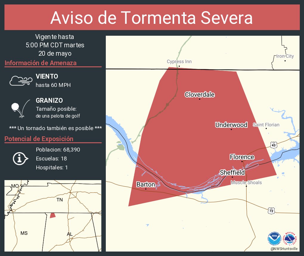
4:47 - Farther north, from Florence and Barton all the way up to Cloverdale, this storm could be producing golfball sized hail as well as winds strong enough to bring down trees and power lines.


4:50 - This has the look of a classic supercell. The hail is dangerous all by itself. The wind threat is dangerous. And the best thing to do is assume that we've got a tornado down on the ground and prepare for that. In your shelter room in the most central, lowest part of your home, it's good to protect your body, especially your head, in case of falling or flying debris. If you have a safety helmet, put it on.

4:52 - And by the way, just a mention for folks up in Middle Tennessee: That storm coming for Murfreesboro has been confirmed by weather spotters to have tennis-ball sized hail. It has the potential to be a destructive storm, even if it doesn't end up producing a tornado. And that's a big if. It can be a close call with some of these supercells on a day like today. Either way, very dangerous storm, please take cover if in the path.
Also take cover if in the path of the possible tornado moving through Columbia.

4:55 - That classic supercell with a possible tornado is coming into the Shoals. People in Town Creek, Lawrence County, be getting ready in case the warning has to be extended to you later. I think it probably will.

4:57 - And here's sort of the broad view. These supercell thunderstorms ahead of the squall line are isolated, but where they are forming, they are packing a punch.

5 PM - Just got a new Severe Thunderstorm Warning that stretches all the way over through Rogersville, Athens, to Madison. Golfball-sized hail is confirmed with this supercell storm. Winds could also gust to 60 mph. And there is a low risk of a tornado spinning up even in this northern part of the storm. There has been weak rotation that comes and goes. Bottom line, you need to be in shelter if in the path of any part of this storm.
5:03 - NWS Huntsville also posted a reminder that this storm has a history of producing funnel clouds. The golfball sized hail, you DON'T want to be caught outside for or driving through either! Pull over to the next sturdy building that will let you in. Get into a sturdy structure, stay on lowest floor, and get away from glass.
5:05 - Here's Brad Travis's stream.
If and when we get a new tornado warning upstream, will start a new post for it, the storm coming out of Colbert and Lauderdale Counties, the Shoals.

5:11 - Here is a look at that rather large severe thunderstorm warning polygon that stretches all the way to Madison.

5:16 - Central Alabama will be added to the Tornado Watch in another hour or two. Technically it'll be a new watch.

5:17 - The tornado warning was allowed to expire. But these two supercell thunderstorms are still capable of damaging winds and very large hail. The one moving East toward Athens has been confirmed to have golfball sized hail with it.

5:21 - And I'm just going to say, this rotation is concerning. This is an area of poor radar coverage too. So if I were you, in the path of this storm, I'd get out of a mobile home and into a sturdier house and take your tornado precautions - get into that lowest, most central room or at least a hallway away from windows. Cover your body, especially your head, if you have time to grab something to help you do that. The hail and straight-line winds are a MORE LIKELY hazard with this storm, but a tornado could develop quickly, it just doesn't look good. And the note in this warning does say a tornado could quickly develop.
And a tornado could quickly develop in this environment. So I'd still stay in a good safe place - small interior room on the lowest floor of a sturdy house, try not to be in a mobile home. And a hallway on the lowest floor away from windows is just fine.

5:25 - Got another possible tornado up there near Chapel Hill, TN - yet another long-lived supercell producing that, you can see the hook echo, don't even have to show velocity. Some of this stuff outside our immediate area, I'm going to mention in passing when I can. But I'm mainly focused on North Alabama and bordering Southern Middle TN counties. And really home base here is Cullman, Walker, and Winston counties.

5:28 - Down here back at the ranch, the rotation is more broad, and I can see why this is a Severe Thunderstorm Warning. The NWS doesn't like to issue any more false alarms for tornadoes than they can help. And this warning is for very large hail and damaging winds, with a note that there is some weak rotation and that a tornado could develop quickly. I think that's exactly the right kind of warning to have out.
I'd go ahead and be in shelter for these severe thunderstorm warnings without worrying about whether or not it could produce a tornado. Why take chances today/tonight? Why not just be safe? Tomorrow and the next several days look absolutely beautiful with comfortable temperatures for this time of year. We just have to get through tonight without people getting hurt. And this kind of large hail, damaging thunderstorm winds can cause serious injury just as well as a tornado can. It's a different kind of danger, that's all. But you need to take shelter from either one.

5:33 - And we've got three overlapping Severe Thunderstorm Warnings now.
For any of those, I would get to shelter and stay there until the threat has passed. If you are anywhere in the polygon in the path of these storms. I'd play it safe and take at least some level of shelter inside a sturdy house or other strong building. I personally would rather nobody stay in a mobile home for this, if they have ANYWHERE else to go at all. Even though there are no clear signs of a tornado anymore with these storms. They are still dangerous, and a tornado could develop quickly in this environment.
Ideally you're in a small interior room or hallway on the lowest floor of a sturdy house or strong building. But at least stay inside and away from windows while these storms come through.
As far as media streams, I think James Spann is doing the best job today. There are a couple other streams I turned off earlier because they were starting to hype things. And he's doing his best to call it straight down the middle.
NEW TORNADO WARNING NEW POST
Tornado Warning
ALC033-077-202215-
/O.NEW.KHUN.TO.W.0040.250520T2129Z-250520T2215Z/
BULLETIN - EAS ACTIVATION REQUESTED
Tornado Warning
National Weather Service Huntsville AL
429 PM CDT Tue May 20 2025
The National Weather Service in Huntsville Alabama has issued a
* Tornado Warning for...
South central Lauderdale County in northwestern Alabama...
Southern Colbert County in northwestern Alabama...
* Until 515 PM CDT.
* At 429 PM CDT, a severe thunderstorm capable of producing a tornado
was located 8 miles northeast of Tishomingo State Park, moving east
at 40 mph.
HAZARD...Tornado and golf ball size hail.
SOURCE...Radar indicated rotation.
IMPACT...Flying debris will be dangerous to those caught without
shelter. Mobile homes will be damaged or destroyed.
Damage to roofs, windows, and vehicles will occur. Tree
damage is likely.
* This dangerous storm will be near...
Cherokee around 435 PM CDT.
Tuscumbia around 450 PM CDT.
Sheffield around 455 PM CDT.
Muscle Shoals around 500 PM CDT.
Other locations impacted by this tornadic thunderstorm include
Malone, Posey Loop, Northwest Alabama Regional Airport, Mt Hester,
New Bethel, Allsboro, Maud, Barton, Red Rock, and Mynot.
PRECAUTIONARY/PREPAREDNESS ACTIONS...
TAKE COVER NOW! Move to a basement or an interior room on the lowest
floor of a sturdy building. Avoid windows. If you are outdoors, in a
mobile home, or in a vehicle, move to the closest substantial shelter
and protect yourself from flying debris.
&&
LAT...LON 3474 8811 3481 8750 3459 8752 3463 8813
TIME...MOT...LOC 2129Z 265DEG 35KT 3469 8808
TORNADO...RADAR INDICATED
MAX HAIL SIZE...1.75 IN
$$
KTW
No comments:
Post a Comment