(Forecast)
Tuesday (High 63, Low 45): Partly to mostly sunny. Cool, especially in the morning.
Wednesday (High 66, Low 36): Sunny. Patchy frost is possible in the morning.
Thursday (High 72, Low 41): Mostly sunny. Temperatures becoming milder.
(Extended Outlook)
Friday (High 78, Low 54): Breezy with increasing clouds and a 40% chance of thunderstorms - some possibly severe.
Saturday (High 76, Low 63): Showers and thunderstorms likely - some storms possibly severe.
Sunday (High 71, Low 47): Sunny.
Monday (High 77, Low 53): Partly cloudy.
(Notes)
Two more basic SKYWARN classes this season from the National Weather Service in Huntsville - one Wednesday evening and another Thursday evening in Morgan and then Madison County, at the Alabama Institute for the Deaf and Blind. Sign language interpreters and CARTS transportation will be provided, since these classes are meant to include people who are deaf or hard of hearing.
It takes some time to assess the kind of tornado damage that this past weekend brought to mainly Mississippi, but if you'd like to look at some of the surveys that have been at least started, then this is a handy reference. I did notice that when the tornado got to Armory, Mississippi, the damage was still consistent with E/F-3 winds. And that was shortly before it crossed the Alabama state line. If the damage in Marion or Franklin Counties has been surveyed yet, I haven't seen it. The Birmingham office has been busy with ongoing severe weather issues in their southern counties the rest of the weekend. It does look like the tornado weakened as it moved into Alabama. Certainly we can be glad that we managed to dodge the kind of damage they had in places like Rolling Fork and Silver City, MS. That same storm did cause a death in our area though once it got absorbed in the squall line and moved through Hartselle. A man was trapped in a mobile home there and ended up dying from the injuries. The tornado was rated F-2 at that point. And that's still a stronger-than-average tornado. When you see that hatched area or hear "strong tornado" in severe weather outlooks, that means they are expecting a pretty good chance of a tornado that can do E/F-2 damage or greater. The majority of tornadoes end up rated E/F0-F1.
(Discussion)
At 10:35 AM the skies are partly cloudy in Cullman, with perfect visibility of 10 miles. The temperature is 63 degrees. The dewpoint is 52, making the relative humidity 68%. Winds have been variable so far today, most often from the North or Northwest, currently sustained about 7 miles per hour, with higher gusts up to 16 mph. Barometric pressure is 30.04 inches and rising. It is sunny and 68 degrees in Jasper. Sunny and 60 in Haleyville, where the North winds are gusting up to 22 miles per hour.
So we dealt with another wave of that cold front yesterday, brought some severe thunderstorms producing really large hail to South Alabama yesterday, also some tornadoes I think, at least one I heard about in Georgia. The severe weather threat has died down now, besides some flash flooding problems ongoing in East Alabama into Georgia. Still got some rain and storms down toward the Gulf Coast though.
Actually I just saw that Southern Georgia is still dealing with the severe weather today, already with a Severe Thunderstorm Watch in effect down there.
And actually what I saw scrolling yesterday or last night must have been wrong about a tornado in Georgia, only tornado report was near Milstead in Macon County, Alabama, where some damage is consistent with a tornado debris signature that was on radar at the time. Mostly these storms were hailers, producing hail big enough to give somebody a concussion.
Some rain stretches all the way back to Texas along this front. Then another front is bringing snow to the Rocky Mountain region, also up into the Dakotas and places like Montana. Have a mix of wintry weather in parts of New England. Besides the Desert Southwest, we are one of the few quiet weather zones in the country today.
Skies will stay sunny around here with a High of about 73 or 74. The breezy conditions should be dying down as we get into the afternoon.
Tomorrow we might get a little moisture from a quick shortwave trough, but only enough for an increase in clouds, no rain expected around here. High should be about 63-64, Low in the morning about 45.
High pressure settles strongly over the Mid-South on Wednesday, and we will be high and dry, sunny skies, and actually a cold morning, could start in the upper 30's or even mid-30's. So some patchy frost is possible, especially up along and North of the Tennessee border. Looking for a High of about 65, or mid-60's anyway.
We should stay mostly sunny on Thursday as well as the High shifts off into the Atlantic. Start the day around 40 degrees and warm to about the lower 70's by afternoon.
Friday we have another front moving through the Mid-South, good strong cold front, capable of producing some severe weather. Looks like around here we'll get up close to 80 degrees, kind of like last week, the Low in the lower-to-mid-50's. Clouds will be increasing, and winds will be picking up on Friday, but I don't know that we see any rain during the day. We may get some storms Friday night. If so we will have to monitor them for severe potential.


The Storm Prediction Center has outlooked a basic 15% severe weather risk for the Plains on Wednesday, and then on Thursday, a large area of the country is covered by that basic risk, but also there is an enhanced 30% risk for parts of the Midwest and Mid-South. This could be a significant severe weather threat. For now the only part of the Tennessee Valley outlooked for this is Northwest Alabama (like around the Shoals) up to about Nashville and points West. And that is only the basic 15% threat level around here, by the way. But they even mention in their discussion, these areas will need to be adjusted as the event gets closer and more data is evaluated. This is the best forecast for now.


The GFS is showing marginal instability and strong wind shear (anyone getting deja vu?) combining over the region late Friday night into the dark hours of Saturday morning. So it does look like we will have some severe weather potential around here. Right now it looks to be on the low end, but recognizing patterns, I think it may be sort of similar to last week's, where we have to watch the mesoscale features once the event is 2-3 days away and see what kind of weather they have out to our West/Northwest to get an idea of what "leftovers" we may be dealing with. The hot zone does appear to be the Mid-South for this event though.
Now the GFS wants to quickly clear us out on Saturday, the first of April.
There is a part of me that is a little uneasy that we might make April Fools of ourselves if we assume that too quickly though. The ECMWF is trending slower with this system. Still got rain and storms here at midday on Saturday. And this model does deserve some respect for performing well over many years, especially when the GFS tries to get in too big a hurry.
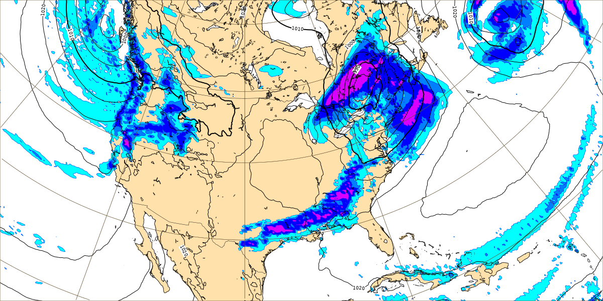
Once in a while I'll peek at the GEM, Canadian model, to see if it breaks the tie. And this time it is on board with the slower timing. This graphic is valid 7 AM on Saturday. And it doesn't have us clearing out until Saturday afternoon and evening.
So this period between Friday and Saturday is uncertain. It seems most likely to be another overnight severe weather threat, but the timing of it may trend more toward Saturday morning than this last one did. Will have to fine-tune those details over the next couple days and adjust the forecast as needed.
Best estimate for temperatures on Saturday is High in mid-70's, Low in lower 60's. Since this is in the extended outlook, think it is best to mention a severe thunderstorm potential for both days since it's dicey how much will be more Friday night versus Saturday morning.
Then high pressure sets in again for Sunday, and we'll have plenty of sunshine, High around 70 or so, Low dipping back down into the 40's.
Then next Monday, the High will quickly rebound into the mid-to-upper 70's, Low back up in 50's, some moisture coming back. And next week it looks like we'll have more chances for storms. This far in advance, with a strong storm system to deal with this weekend, there is no way to assess any severe potential with accuracy out that far. But remember that this is the peak of our severe weather season since people have been keeping good records. The weather stays active this time of year, and we have to keep a close eye on any storm system to see if it wants to get a little bit rowdy. Rain chances looking minimal on Monday for now, but clouds will at least be increasing, good moisture return to set up for whatever our next rainmaker/storm system does next week.
Rainfall totals for this forecast period will probably average between 0.5-1 inch. Because not really expecting any more rain until Friday night into Saturday morning. When we get the storms.


No comments:
Post a Comment