Saturday, December 30, 2023

Sunshine to Start the New Year, Dynamic Cold Pattern Continues Next Week

(Forecast)

Sunday (High 56, Low 29): Sunny, breezy, and seasonably cold. Patchy fog is possible in the morning and could freeze. 

New Year's Day (High 45, Low 30): Mostly sunny. Lightly breezy and seasonably cold. 

Tuesday (High 50, Low 22): Sunny. Very cold, especially in the morning. 

(Extended Outlook)

Wednesday (High 48, Low 28): Overcast with a 30% chance of showers. 

Thursday (High 46, Low 29): Sunny.

Friday (High 52, Low 21): Sunny.

Saturday (High 44, Low 33): Showers likely. 

(Pronóstico)

Domingo (Máxima 56, Mínima 29): Soleado, con brisa y frío estacional. Es posible que haya niebla irregular por la mañana y podría congelarse.

Día de Año Nuevo (Máxima 45, Mínima 30): Mayormente soleado. Ligeramente ventoso y estacionalmente frío.

Martes (Máxima 50, Mínima 22): Soleado. Mucho frío, especialmente por la mañana.

(Perspectiva Extendida)

Miércoles (Máxima 48, Mínima 28): Nublado con un 30 % de probabilidad de lluvias.

Jueves (Máxima 46, Mínima 29): Soleado.

Viernes (Máxima 52, Mínima 21): Soleado.

Sábado (Máxima 44, Mínima 33): Lluvias probables.

(Notes)

Here are some reminders about winter weather safety.

And as I mention from time to time, I am still brushing back up on my Spanish (and not always consistently), so if anyone notices mistakes in that version of the forecast, leave a comment or e-mail me with suggestions on how to improve it. 

(Discussion)


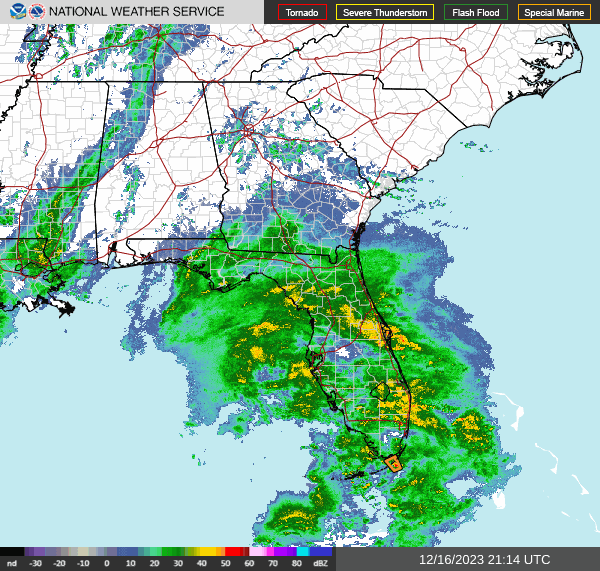
It was an overcast day in the Tennessee Valley. There was some light rain and a wintry mix here and there last night and this morning, but we did not see any meaningful accumulation of snow. The High in Cullman was 41, and the Low was 34. The High in Jasper was 43, and the Low so far is 34, could drop below that before midnight tonight. And in Haleyville, the High was 40 with a Low of 34. 

Yesterday my dear cat Salem destroyed a laptop by spilling a beverage into the vents. However, I had a backup engine that ended up being a better computer than I remembered. So far it is working fine. A wonderful lady today brought me some better things for him to chew on than computer cords and coffee mugs and ear buds . . . 

Back to the weather, this clipper system is on its way out. 


Tonight into tomorrow morning, there is some concern for patchy freezing fog, mainly in valleys and near lakes or other bodies of water. But overall tomorrow will be a sunny day as high pressure dominates our region. It will still be breezy. High should get up to about 56-57, and we should start the day about 30 degrees or maybe even 29-28. 


The proper cold front passage through our region will take place tomorrow night into New Year's Day (Monday). We might see a slight increase in clouds as that process is underway, but not much, mostly sunshine, High near about 45, Low near 30 again. And we'll still be a little bit breezy as winds shift around to the North. 


On Tuesday we come under a stout ridge of high pressure that will make for an even colder morning, expecting the Low all the way down in the lower 20's here. (That's getting cold enough that you might want to check on your pipes and pets as well as people who might not have adequate heat. Though we've already had a lot of cold weather this season so far. That's still worth respecting.) And then in the sunshine, we'll warm up to about 50 degrees in the afternoon. 

By the way, those people who were advertising a snowstorm for New Year's were dead wrong, as usual. Ignore the alarmists who give flimsy evidence like rogue model data without factoring in the bigger picture. If you've got good sense. 

The models were showing a low chance of rain for a while at New Year's, but that trend has gone away completely. That's why I'm not doing a 10-Day-Outlook here. This weather pattern is dynamic enough that 7 Days is challenge enough, getting it right. 


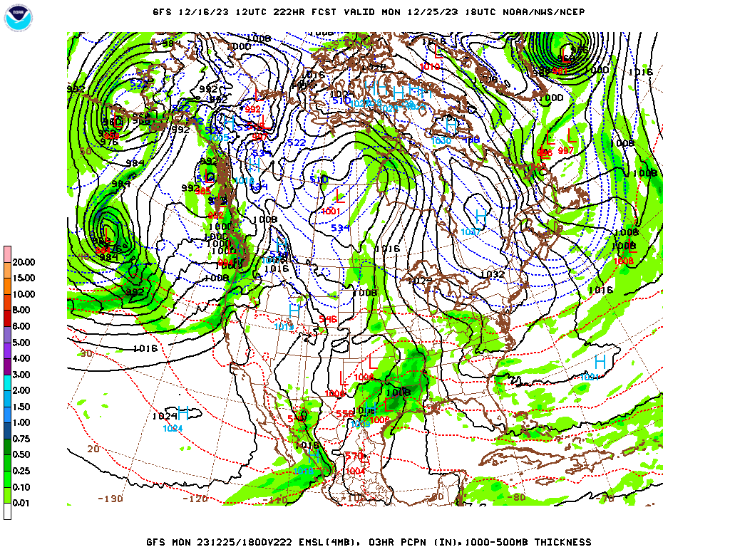
The GFS has started to trend the rain on Wednesday with this next low pressure system to our South down closer to the Gulf Coast and along there. 


The ECWMF has a similar look between Noon and 6 PM Wednesday, but it shows a little better chance of North Alabama getting some of the rain. 

Some earlier model runs did not bring this so far South. But I'm only going to forecast a 30% chance of rain here, expecting a raw overcast day, High dropping to upper 40's from the clouds and widely scattered rain. Should start the day in upper 20's or near 30. 

And we'll really have to watch Wednesday night into Thursday morning, the temperatures and timing. We could see some rain trying to freeze Thursday morning on some surfaces like bridges, and we could also see a wintry mix of some snow Wednesday night/Thursday morning depending on the timing of the system, how far North the rain does get, and the exact temperatures that coincide with this. 


And we'll be cold again Thursday morning, thus the slight concern for a few icing issues or if a snow mix or snow changeover would be possible in a few places. Should start the day around 30 degrees but could be barely into upper 20's, and then only warm to mid-40's during the day. But the sunshine will be back during the daylight hours. Got a strong high pressure system moving through the Midwest that will affect our weather behind this Wednesday system. 


That high pressure system will move swiftly through our region and to the Mid-Atlantic on Friday. And we will have another very cold morning, Low in the lower 20's, before warming to about 50 or so, lower 50's, for the afternoon High. 


Then the GFS brings another swift low pressure system to our region on Saturday the 6th. 


If anything, the ECMWF looks even better, so confidence is pretty good in this basic scenario even though it's seven days out. As of right now, all the precipitation is expected to fall in the form of rain. But it is sort of a close call. Temperatures are expected to be mid-40's for Highs and mid-30's for Lows. And it's still seven days out. So it's worth keeping an eye on given the time of year and this cold, dynamic pattern we are in. You have to watch every system for any wintry potential. But right now, things are trending away from that and toward just a cold rain. 


Even on Wednesday/Thursday, there is only a small area along the border of Tennessee and the Carolinas that is outlooked for any meaningful snow accumulations, anywhere close to here. 

The concern for any light snow accumulation Wednesday night is slight, but considering the temperatures Thursday morning and at least some rain on surfaces like bridges, still have to watch for some slick spots on the roads or at least those elevated surfaces. We don't have a whole lot of wintry weather around here all that often, so when we get even a little bit, sometimes we have problems because people do not pay attention to it, and try to drive exactly like if nothing was going on. So nothing in this forecast period looks like a big threat (except the really cold mornings, you wouldn't want anyone, even a pet, to be without adequate heat on one of those mornings, but that's common sense), but just a reminder that even a dusting of snowflakes and some rain trying to freeze on at least the elevated surfaces like bridges can cause some problems if people do not pay attention. So I'd keep that in mind just in case, but wouldn't let it worry you. 

The rainfall totals for this forecast period will probably be about up to an inch on average, and up in the Tennessee counties, probably looking at more like a half-inch or less. 

Here comes a new year. Make it a good one if you are so inclined. 

One last note: After reviewing the overall pattern, I went with "likely" precipitation for next Saturday (the 6th) and the Low in the lower 30's. It is still a borderline situation if you're hoping for or dreading any snow. It's worth keeping an eye on but not worth getting worked up about. 

Thursday, December 28, 2023

Light Snow Showers May Mix With Rain Tonight Into Tomorrow

(Forecast)

Friday (High 40, Low 30): Cloudy. Widely scattered rain showers are possible, and may mix with snow showers at times - little or no accumulation of snow is expected.

Saturday (High 47, Low 29): Mostly sunny. Seasonably cold. 

New Year's Eve (High 55, Low 24): Sunny. Cold.

(Extended Outlook)

New Year's Day (High 49, Low 35): Mostly cloudy with a 40% chance of showers. 

Tuesday (High 48, Low 26): Sunny.

Wednesday (High 46, Low 28): Partly to mostly cloudy with a 30% chance of showers. 

Thursday (High 50, Low 30): Partly to mostly sunny with a 20% chance of lingering showers. 

(Reading Tea Leaves)

Friday January 5th (High 51, Low 29): Mostly sunny.

Saturday January 6th (High 50, Low 30): Partly to mostly cloudy with a 20% chance of showers.

Sunday January 7th (High 49, Low 31): Partly to mostly cloudy with a 30% chance of showers. 

Tuesday, December 26, 2023

Cold Pattern, Light Rain/Snow Showers Possible Thursday Night Into Friday

Wednesday (High 55, Low 32): Mostly sunny. Seasonably cold. 

Thursday (High 46, Low 30): Mostly sunny during the day. Increasing clouds with isolated rain/snow showers possible at night.

Friday (High 40, Low 29): Partly to mostly cloudy. Isolated rain/snow showers are possible - accumulation, if any, is expected to be light.

Saturday (High 50, Low 26): Mostly sunny.

Sunday (High 53, Low 28): Mostly sunny.

New Year's (High 49, Low 30): Partly to mostly cloudy with a 20% chance of showers.

Tuesday (High 44, Low 22): Sunny. 

Monday, December 25, 2023

Colder Air Returns, Slight Chance of Light Snow Showers Thursday Night

Tuesday (High 55, Low 46): Partly to mostly sunny. Seasonably cold. 

Wednesday (High 56, Low 33): Mostly sunny during the day. An isolated shower is possible at night. 

Thursday (High 45, Low 30): Partly cloudy. Isolated rain/snow showers are possible at night, but are expected to remain light.

Friday (High 44, Low 29): Partly cloudy with a 20% chance of light rain/snow showers.

Saturday (High 50, Low 24): Sunny.

New Year's Eve (High 52, Low 27): Mostly sunny.

New Year's Day (High 51, Low 31): Partly cloudy with a 30% chance of showers. 

Saturday, December 23, 2023

Rainy and Windy for Christmas, Then a Return to Seasonably Cold, Dry Air Into the New Year

(Forecast)

Christmas Eve (High 64, Low 46): Partly cloudy during the day. Rain moving in at night, becoming breezy. 

Christmas (High 62, Low 55): Rainy. Windy.

Tuesday (High 57, Low 48): Mostly sunny. 

(Extended Outlook)

Wednesday (High 55, Low 35): Mostly sunny. 

Thursday (High 49, Low 30): Mostly sunny. 

Friday (High 45, Low 27): Mostly sunny. 

Saturday (High 46, Low 24): Sunny.

(Reading Tea Leaves)

New Year's Eve (High 48, Low 25): Sunny.

New Year's Day (High 50, Low 28): Mostly sunny.

Tuesday (High 52, Low 30): Mostly sunny. 

(Pronóstico)

Nochebuena (Máxima 64, Mínima 46): Parcialmente nublado durante el día. Lluvia que llega por la noche y se vuelve ventosa.

Navidad (Máxima 62, Mínima 55): Lluvioso. Ventoso.

Martes (Máxima 57, Mínima 48): Mayormente soleado.

(Perspectiva Extendida)

Miércoles (Máxima 55, Mínima 35): Mayormente soleado.

Jueves (Máxima 49, Mínima 30): Mayormente soleado.

Viernes (Máxima 45, Mínima 27): Mayormente soleado.

Sábado (Máxima 46, Mínima 24): Soleado.

(Leyendo Hojas de Té)

Nochevieja (Máxima 48, Mínima 25): Soleado.

Día de Año Nuevo (Máxima 50, Mínima 28): Mayormente soleado.

Martes (Máxima 52, Mínima 30): Mayormente soleado.

Thursday, December 21, 2023

Milder Temperatures, Then a Wet Christmas, Then Turning Cold Again

(Forecast)

Friday (High 60, Low 34): Mostly sunny. Milder temperatures. 

Saturday (High 63, Low 38): Partly cloudy. Mild. 

Christmas Eve (High 65, Low 44): Partly to mostly cloudy, breezy at times. Scattered showers are possible at night. 

(Extended Outlook)

Christmas (High 62, Low 51): Rain.

Tuesday (High 55, Low 47): Mostly sunny.

Wednesday (High 54, Low 37): Mostly sunny.

Thursday (High 55, Low 33): Sunny. 

Tuesday, December 19, 2023

Staying Cold Until the Weekend, Looks Like Some Rain For Christmas

Today (High 46): Sunny. Cold.

Wednesday (High 52, Low 25): Mostly sunny. Staying cold. 

Thursday (High 55, Low 28): Mostly sunny. Staying cold. 

Friday (High 58, Low 31): Partly cloudy. 

Saturday (High 60, Low 38): Partly cloudy.

Christmas Eve (High 61, Low 40): Partly cloudy with a 20% chance of showers.

Christmas (High 60, Low 42): Mostly cloudy with a 40% chance of showers. 

Saturday, December 16, 2023

Storm Surveys From Tennessee December 10th


 Public Information Statement

National Weather Service Nashville TN

340 PM CST Thu Dec 14 2023


...NWS Damage Survey for 12/09/2023 Tornado Event - Update #8...


.Update...Extended Davidson/Sumner County tornado track into

Trousdale County and added tornado for Clay/Monroe Counties. This

brings the total number of tornadoes to 7 across Middle Tennessee

for December 9th. At this time, unless additional storm damage is

reported, this will conclude our surveys from this event.


.Overview...A strong storm system moved through Middle TN on

Saturday afternoon December 9, 2023, producing 7 tornadoes in

Middle TN. Additional tornadoes occurred across West TN, southern

KY, MS, and AL.


.Indian Mound EF-1 Tornado...


Rating:                 EF1

Estimated Peak Wind:    110 mph

Path Length /statute/:  7.31 miles

Path Width /maximum/:   75 yards

Fatalities:             0

Injuries:               0


Start Date:             12/09/2023

Start Time:             01:20 PM CST

Start Location:         5 ENE Dover / Stewart County / TN

Start Lat/Lon:          36.495 / -87.7428


End Date:               12/09/2023

End Time:               01:30 PM CST

End Location:           9 N Cumberland City / Montgomery County / TN

End Lat/Lon:            36.5211 / -87.6158


Survey Summary:

The tornado first touched down just east of the Cumberland River

near Cross Creeks National Wildlife Refuge off of Commissary

Hollow Road. Minor damage was observed to trees with a home

sustaining significant roof damage.  the tornado continued east-

northeast where dozens more trees were snapped and uprooted along

Lower Cross Creek Road.  Once the tornado entered Indian Mound,

more trees were either uprooted or snapped along Highway 46.  The

tornado then intensified on Red Top Road and Gillum Hollow Road

where a church overhang awning and greenhouses were damaged.  A

few more barns and outbuildings were damaged along Gillum Hollow

Road with several instances of uprooted and snapped trees along

its path including a tree falling onto a residence. The tornado

finally began to weaken as it entered into far western portions

of Montgomery County where only a few large branches were broken.

The tornado then lifted near Indian Mound Road and Liverpool

Road.


.Clarksville EF-3 Tornado...


Rating:                 EF3

Estimated Peak Wind:    150 mph

Path Length /statute/:  43 miles total (11.31 miles in TN)

Path Width /maximum/:   600 yards

Fatalities:             3

Injuries:               62


Start Date:             12/09/2023

Start Time:             01:41 PM CST

Start Location:         5 S Fort Campbell North / Montgomery County / TN

Start Lat/Lon:          36.5746 / -87.4718


End Date:               12/09/2023

End Time:               01:56 PM CST

End Location:           5 S Trenton / Todd County / KY

End Lat/Lon:            36.6418 / -87.2867


Survey Summary:

This EF-3 tornado first touched down on Fort Campbell just north

of the Sabre Airfield with mostly minor tree damage. It quickly

intensified as crossed Walnut Grove Road and destroyed a building

next to a church. The tornado then continued northeast and

damaged dozens of homes in a neighborhood along Garrettsburg Road

near Purple Heart Highway. The tornado then went through a

heavily wooded neighborhood south of Britton Springs Road where

dozens of mobile and manufactured homes were destroyed. The

tornado crossed into another neighborhood causing heavy damage in

and near Eva Drive, with several houses shifted off their

foundations that were only attached with straight nails

(EF2/120mph). The tornado intensified to EF-3 (140 mph) as it

crossed Highway 41 and struck several commercial businesses,

including a vacant fast food restaurant and strip mall where only

the interior remained. Just east of Highway 41 north of Ringgold

Road, another neighborhood was struck with several homes

sustaining significant damage. As the tornado continued

northeast, it strengthened further to EF-3 (150mph), destroying

four two story brick and vinyl siding homes on Henry Place Blvd.

Debris was blown across the field towards West Creek Elementary

School where the school sustained roof damage. As the tornado

crossed Peachers Mill Road, two dozen brand new two story brick

apartment homes were severely damaged with roofs missing on at

least a dozen of these structures. Dozens more houses suffered

significant roof damage along and near Needmore Road and Tiny

Town Rd (EF-2). The tornado then crossed I-24 at Trenton Road

where numerous cedar trees were uprooted. Continuing across

Tylertown Road, the tornado caused EF-1 to EF-2 damage roof and

siding damage to dozens of homes across 3 neighborhoods before

moving into Kentucky. A total of nearly 1000 homes were impacted

by the tornado, including 114 homes destroyed and 268 homes with

major damage, with 3 people killed and 62 injured.


.Cumberland Furnace EF-2 Tornado...


Rating:                 EF2

Estimated Peak Wind:    125 mph

Path Length /statute/:  5.83 miles

Path Width /maximum/:   300 yards

Fatalities:             0

Injuries:               1


Start Date:             12/09/2023

Start Time:             03:29 PM CST

Start Location:         3 ESE Slayden / Dickson County / TN

Start Lat/Lon:          36.2793 / -87.4138


End Date:               12/09/2023

End Time:               03:39 PM CST

End Location:           8 N Charlotte / Dickson County / TN

End Lat/Lon:            36.3029 / -87.3137


Survey Summary:

This EF-2 tornado touched down southwest of the intersection of

Woods Valley Road and Bone Road, then moved east-northeast where

it snapped a few pine trees and caused roof damage to a home.

Continuing east-northeast, the tornado damaged a mobile home and

outbuilding on Gamble Hollow Road. The tornado intensified to EF-

2 as it crossed Highway 48, causing the most significant damage

along its path as it completely removed the top level of a home,

leaving only the lower exterior walls in place. Winds were

estimated at 125 mph in this area. The tornado maintained its

strength as it continued toward Freeman Loop, striking an A-frame

house and ripping off the top half of the home. As it continued

eastward, the tornado did substantial damage to another mobile

home and snapped and uprooted dozens of trees along Freeman Loop

before finally lifting after crossing Barton`s Creek.


.White Bluff EF-2 Tornado...


Rating:                 EF2

Estimated Peak Wind:    125 mph

Path Length /statute/:  18.76 miles

Path Width /maximum/:   500 yards

Fatalities:             0

Injuries:               0


Start Date:             12/09/2023

Start Time:             04:03 PM CST

Start Location:         4 NNW White Bluff / Dickson County / TN

Start Lat/Lon:          36.1601 / -87.2335


End Date:               12/09/2023

End Time:               04:27 PM CST

End Location:           7 WNW Nashville / Davidson County / TN

End Lat/Lon:            36.2162 / -86.9066


Survey Summary:

The tornado touched down in the Claylick community in eastern

Dickson County snapping and uprooting several trees and

destroying an outbuilding. It quickly intensified to low end EF-

2 strength as it crossed Nosegay Road and demolished a single

story manufactured home. The tornado continued to Pack Annex Road

where it did minor damage to the tops of high-tension power lines

and continued to snap large trees as it moved northeast into

Cheatham County. Uprooted trees and minor roof damage occurred in

the Griffintown area of Cheatham County. The tornado weakened and

caused sporadic tree damage as it moved into Cheatham Wildlife

Management Area. It strengthened once more, causing prolific tree

damage and structure damage to homes along Dry Creek Road south

of Ashland City. Just before leaving Cheatham county, the tornado

caused minor outbuilding damage and snapped a few trees near

River Road. At this point, the tornado crossed in Davidson county

and crossed the Cumberland River. On Pecan Valley road, some

structural damage was observed, but damage was consistent with

weakening tornado (EF-1/90 mph). The tornado lifted after

crossing Old Hickory Blvd, just north of Ashland City Highway.


.Springfield EF-2 Tornado...


Rating:                 EF2

Estimated Peak Wind:    120 mph

Path Length /statute/:  3.52 miles

Path Width /maximum/:   300 yards

Fatalities:             0

Injuries:               4


Start Date:             12/09/2023

Start Time:             04:19 PM CST

Start Location:         1 S Springfield / Robertson County / TN

Start Lat/Lon:          36.4784 / -86.883


End Date:               12/09/2023

End Time:               04:24 PM CST

End Location:           3 E Springfield / Robertson County / TN

End Lat/Lon:            36.4993 / -86.8261


Survey Summary:

This EF-2 tornado touched down near Fairway Trail and Kemper Court

in southern Springfield. Moving northeast, the tornado snapped and

uprooted trees along many residential streets and caused minor

damage to a few homes. More significant damage to homes occurred

further northeast on Rudolph Street and Brentlawn Drive. The

tornado strengthened as it crossed Highway 41 near the Kroger

shopping center, with numerous businesses damaged from high-end

EF1 to low-end EF2 intensity (110-115 mph). 25 vehicles in the

Kroger parking lot were flipped with some thrown into nearby

ditches. The tornado then crossed the railroad tracks behind

Kroger and reached its peak intensity as it entered an industrial

area, where multiple warehouse structures were heavily damaged.

With the majority of these metal building systems having Grade 5

bolts holding down the columns, winds were estimated at EF-2/120

mph in this area. The tornado then struck a fire department and

strip mall (EF-1/110 mph) and bent a steel transmission pole at a

power substation (EF-2/115 mph) on the east side of the

industrial park. As the tornado continued northeast, it

significantly weakened but still uprooted trees and caused minor

roof damage to homes on Greystone Drive and Sloan Lane. On Roy

Pitt Road, the tornado destroyed a two car garage and rolled a

trailer on its side (EF-1). The tornado finally lifted near the

intersection of Oakland Road and Highway 76E.


.Davidson/Sumner/Trousdale EF-2 Tornado...


Rating:                 EF2

Estimated Peak Wind:    130 mph

Path Length /statute/:  35.02 miles

Path Width /maximum/:   400 yards

Fatalities:             3

Injuries:               Unknown


Start Date:             12/09/2023

Start Time:             04:39 PM CST

Start Location:         5 N Nashville / Davidson County / TN

Start Lat/Lon:          36.255 / -86.7852


End Date:               12/09/2023

End Time:               05:27 PM CST

End Location:           5 NW Hartsville / Trousdale County / TN

End Lat/Lon:            36.4567 / -86.2129


Survey Summary:

This strong EF-2 tornado touched down just to the east of I-24

west of Brick Church Lane. There were a few trees down and

shingle damage to several homes in this area. The tornado

strengthened in the Madison area causing EF-2 damage with winds up

to 120-125 mph. The heaviest damage was confined to two areas,

off of East Campbell Road as well as Nesbitt Lane. Multiple mobile

homes were destroyed on Nesbitt Lane. This is where 3 fatalities

occurred. Multiple single family homes and a church off of East

Campbell Road were missing large sections of their roofs, with

some exterior walls collapsed. Several metal power poles in the

area were bent as well. Nearby, an apartment complex off Palmer

Avenue sustained damage. As the tornado moved further northeast,

substantial damage was found to houses in a cul-de-sac on Stoney

River Lane. Two buildings were toppled and several others damaged

in an industrial complex off of Myatt Drive. The tornado then

continued across the Cumberland River and Old Hickory Lake, coming

onshore again in the immediate dam vicinity. It is this location

in which the strongest winds were found, up to 130 miles per hour,

due to substantial damage to a grove of hundreds of trees in

which all of them were either snapped, uprooted, or missing major

branches. The tornado persisted into Hendersonville downing

hundreds of trees and causing roof damage to multiple homes. It

damaged many businesses along Main Street. The tornado continued

northeast into Gallatin where EF-2 (115 mph) damage was found to a

few homes in The Club at Foxland Harbor as we as the Foxland

Harbor Golf and Country Club. At this point, the tornado began to

weaken, though EF-1 damage was found as it crossed Hwy 109 and

Steam Plant Road. Several trees were still found to be uprooted,

along with minor roof and shingle damage to a couple of homes as

the tornado crossed Hartsville Pike. Scattered trees continued to

be blown down along Lauderdale Lane and Homer Scott Road before

the tornado crossed Highway 231 into Trousdale County. Trees

continued to be blown down on Browning Branch Road and a home

suffered significant roof and porch damage on Hawkins Branch Road.

Trees continued to be blown down until the tornado lifted near

Shephard Hollow Lane. Around 600 homes/businesses were damaged in

Sumner County.


.Harlan Crossroads KY EF-1 Tornado...


Rating:                 EF1

Estimated Peak Wind:    90 mph

Path Length /statute/:  2.51 miles

Path Width /maximum/:   50 yards

Fatalities:             0

Injuries:               0


Start Date:             12/09/2023

Start Time:             06:07 PM CST

Start Location:         3 SSW Harlan Crossroads / Clay County / TN

Start Lat/Lon:          36.6169 / -85.723


End Date:               12/09/2023

End Time:               06:11 PM CST

End Location:           1 WNW Boles / Monroe County / KY

End Lat/Lon:            36.6308 / -85.683


Survey Summary:

A brief EF-1 tornado touched down just south of the Kentucky

border in Clay County where it blew down a few trees on Barber

Shop Road (EF-0). The tornado intensified to EF-1 as it moved

northeast into Kentucky and caused significant roof and siding

damage to several chicken barns on Harlans Crossroads. A home

also lost its porch and part of its roof on Red Hill-Beech Grove

Road. A few more trees were blown down west of Beech Groves-Boles

Road before the tornado lifted.


&&


EF Scale: The Enhanced Fujita Scale classifies tornadoes into the

following categories:


EF0.....65 to 85 mph

EF1.....86 to 110 mph

EF2.....111 to 135 mph

EF3.....136 to 165 mph

EF4.....166 to 200 mph

EF5.....>200 mph


NOTE:

The information in this statement is preliminary and subject to

change pending final review of the events and publication in

NWS Storm Data.


$$

Some Rain Tonight, Clearing and Much Colder for the New Week

(Forecast)

Sunday (High 56, Low 47): Showers ending during the morning. Becoming partly to mostly sunny, cold and breezy.

Monday (High 50, Low 35): Sunny. Cold and breezy.

Tuesday (High 45, Low 23): Sunny. Cold. 

(Extended Outlook)

Wednesday (High 51, Low 24): Mostly sunny.

Thursday (High 55, Low 27): Mostly sunny. 

Friday (High 58, Low 32): Partly cloudy.

Saturday (High 60, Low 38): Partly cloudy with a 30% chance of showers. 

(Pronóstico)

Domingo (Máxima 56, Mínima 47): Lluvias que terminarán durante la mañana. Volviéndose parcialmente a mayormente soleado, frío y ventoso.

Lunes (Máxima 50, Mínima 35): Soleado. Frío y ventoso.

Martes (Máxima 45, Mínima 23): Soleado. Frío.

(Perspectiva Extendida)

Miércoles (Máxima 51, Mínima 24): Mayormente soleado.

Jueves (Máxima 55, Mínima 27): Mayormente soleado.

Viernes (Máxima 58, Mínima 32): Parcialmente nublado.

Sábado (Máxima 60, Mínima 38): Parcialmente nublado con un 30 % de probabilidad de lluvias.

(Notes)

Here are some reminders about staying safe in winter weather. 

Having said that, we had the warmest Arctic summer on record this year. 

Here is a look at the tornadoes that hit Tennessee last weekend. There were also damaging straight-line winds and a couple tornadoes near Birmingham that night. Some of the stories are quite saddening and underline why people need to be able to get out of mobile homes before a tornado hits. 

(Discussion)

At 3 PM we have a few clouds in the sky in Cullman. The temperature is 59, and that may very well be our High for today. The dewpoint is 43, making the relative humidity 55%. Winds are from the Southeast at 8 miles per hour, with higher gusts to 15 mph. The pressure is 30.10 inches and falling. It's been a mostly overcast day with periods of light rain. The Low this morning was 45 degrees. 

Jasper is fair with haze. Their visibility is down to 2 miles. The temperature is 61, with a dewpoint of 48, making the relative humidity 63%. Winds are from the Southeast at 8 mph. Pressure is 30.07 inches and falling. Their High was 63 today, and the Low this morning was 34, much wider range in the temperatures down that way. 

Haleyville is mostly cloudy at this hour with a temperature of 57 degrees. The dewpoint is 46 degrees, making the relative humidity 67%. Winds are from the Southeast at 10 mph with higher gusts up to 17 mph. The pressure is 30.06 inches/1017.4 millibars and falling. 

Elsewhere around the region, Fort Payne is overcast and 56 degrees. Decatur has fair skies and 60 degrees. Overcast and 60 in Huntsville. Overcast and 59 in Muscle Shoals. Overcast and 58 in Tupelo. Overcast and 53 in Memphis, visibility down to 7 miles. And mostly cloudy and 60 in Nashville. 


We have a trough and cold front moving into our region from the West, and also are getting some rain from a low pressure system that is affecting Florida tonight and will affect the Carolinas tomorrow. They actually have some potential for severe thunderstorms with this, while we will only get a cool, beneficial rain and some gusty winds around here. 


That front and trough will move through here tonight and tomorrow. It is now looking like tomorrow will be mostly dry, with only isolated rain in the morning, then partly to mostly sunny skies and a temperature rising to about 55 or 56 in the afternoon behind the cold front. Tonight's Low should be in the mid-40's, maybe upper 40's, but we'll have periods of rain showers.


High pressure will dominate the nation's midsection on Monday, and our skies will stay sunny around here, a High near 50 and a Low down in the mid-30's. By the way, we are still going to have quite a breeze tomorrow and Monday, so be mindful of the wind chill factor, especially at night and in the morning. 


The core of the high pressure system will move through our region on Tuesday. Skies will be sunny, but it looks like we'll start the day in the lower 20's and only warm to about the mid-40's. 


The high pressure moves to the Mid-Atlantic coast on Wednesday, and it still looks frigid around here, actually pretty seasonable, but just a sharp contrast to this weekend, for example. Starting the day in the lower-to-mid-20's and warming only to about 50 degrees or so in the afternoon. 


Another mostly sunny day on Thursday with a High in the mid-50's and Low rebounding more into the upper 20's. 


Then clouds will be on the increase on Friday with the approach of another cold front. Expecting a High in upper 50's, Low in lower 30's. 


Then Saturday we'll have to include some rain chances again. High should be near 60 and the Low in the upper 30's. Chance of rain is 30% for now. This is seven days out. 


Then I'd bring the rain chance up to 40% for Christmas Eve based on the GFS. High should be near 60, Low near 40. 


And here's something important, since forecasting out to 10 days is always kind of dicey to begin with: The ECMWF is a lot slower with the timing of this system, has a very different look. 

So it might be better to do a 20% chance of rain for Saturday and then 30% for Sunday/Christmas Eve. 


Then for Christmas the GFS would make me inclined to trim the rain chance back a little. 


While the ECMWF would really increase it. If I had to make a forecast here I'd go with a 30% chance of rain considering the model madness. 


And the mess continues on Tuesday, the day after Christmas. 


With the ECMWF having a different timing and placemen of everything from the GFS. 

And seeing just what a mess this is, I'm going to refrain from the 10-Day-Forecast I had planned on. Wait until Christmas gets within the 7-Day range. It's not worth throwing a forecast up there when confidence is this low. 


Rainfall amounts for this forecast period should stay light, probably less than a quarter-inch for most of us. The heavier rains ended up being focused on Florida up through the Mid-Atlantic coastal region. 

One National Weather Service forecaster mentioned today to remember the "Five P's" of cold weather safety: Protect people, pipes, pets, and plants . . . and Practice fire safety. Sounded like good advice to me. 

Staying Mostly Sunny and Warm, Rain Pretty Scarce Through Next Week

FORECAST: Friday (High 81, Low 59): Partly to mostly sunny. Warm and breezy. Saturday (High 82, Low 61): Mostly sunny. Warm and breezy.  Sun...