

(Forecast)
Sunday (High 56, Low 47): Showers ending during the morning. Becoming partly to mostly sunny, cold and breezy.
Monday (High 50, Low 35): Sunny. Cold and breezy.
Tuesday (High 45, Low 23): Sunny. Cold.
(Extended Outlook)
Wednesday (High 51, Low 24): Mostly sunny.
Thursday (High 55, Low 27): Mostly sunny.
Friday (High 58, Low 32): Partly cloudy.
Saturday (High 60, Low 38): Partly cloudy with a 30% chance of showers.
(Pronóstico)
Domingo (Máxima 56, Mínima 47): Lluvias que terminarán durante la mañana. Volviéndose parcialmente a mayormente soleado, frío y ventoso.
Lunes (Máxima 50, Mínima 35): Soleado. Frío y ventoso.
Martes (Máxima 45, Mínima 23): Soleado. Frío.
(Perspectiva Extendida)
Miércoles (Máxima 51, Mínima 24): Mayormente soleado.
Jueves (Máxima 55, Mínima 27): Mayormente soleado.
Viernes (Máxima 58, Mínima 32): Parcialmente nublado.
Sábado (Máxima 60, Mínima 38): Parcialmente nublado con un 30 % de probabilidad de lluvias.
(Notes)
Here are some reminders about staying safe in winter weather.
Having said that, we had the warmest Arctic summer on record this year.
Here is a look at the tornadoes that hit Tennessee last weekend. There were also damaging straight-line winds and a couple tornadoes near Birmingham that night. Some of the stories are quite saddening and underline why people need to be able to get out of mobile homes before a tornado hits.
(Discussion)
At 3 PM we have a few clouds in the sky in Cullman. The temperature is 59, and that may very well be our High for today. The dewpoint is 43, making the relative humidity 55%. Winds are from the Southeast at 8 miles per hour, with higher gusts to 15 mph. The pressure is 30.10 inches and falling. It's been a mostly overcast day with periods of light rain. The Low this morning was 45 degrees.
Jasper is fair with haze. Their visibility is down to 2 miles. The temperature is 61, with a dewpoint of 48, making the relative humidity 63%. Winds are from the Southeast at 8 mph. Pressure is 30.07 inches and falling. Their High was 63 today, and the Low this morning was 34, much wider range in the temperatures down that way.
Haleyville is mostly cloudy at this hour with a temperature of 57 degrees. The dewpoint is 46 degrees, making the relative humidity 67%. Winds are from the Southeast at 10 mph with higher gusts up to 17 mph. The pressure is 30.06 inches/1017.4 millibars and falling.
Elsewhere around the region, Fort Payne is overcast and 56 degrees. Decatur has fair skies and 60 degrees. Overcast and 60 in Huntsville. Overcast and 59 in Muscle Shoals. Overcast and 58 in Tupelo. Overcast and 53 in Memphis, visibility down to 7 miles. And mostly cloudy and 60 in Nashville.


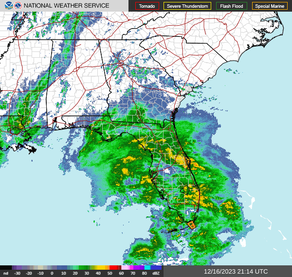


We have a trough and cold front moving into our region from the West, and also are getting some rain from a low pressure system that is affecting Florida tonight and will affect the Carolinas tomorrow. They actually have some potential for severe thunderstorms with this, while we will only get a cool, beneficial rain and some gusty winds around here.


That front and trough will move through here tonight and tomorrow. It is now looking like tomorrow will be mostly dry, with only isolated rain in the morning, then partly to mostly sunny skies and a temperature rising to about 55 or 56 in the afternoon behind the cold front. Tonight's Low should be in the mid-40's, maybe upper 40's, but we'll have periods of rain showers.


High pressure will dominate the nation's midsection on Monday, and our skies will stay sunny around here, a High near 50 and a Low down in the mid-30's. By the way, we are still going to have quite a breeze tomorrow and Monday, so be mindful of the wind chill factor, especially at night and in the morning.


The core of the high pressure system will move through our region on Tuesday. Skies will be sunny, but it looks like we'll start the day in the lower 20's and only warm to about the mid-40's.


The high pressure moves to the Mid-Atlantic coast on Wednesday, and it still looks frigid around here, actually pretty seasonable, but just a sharp contrast to this weekend, for example. Starting the day in the lower-to-mid-20's and warming only to about 50 degrees or so in the afternoon.


Another mostly sunny day on Thursday with a High in the mid-50's and Low rebounding more into the upper 20's.


Then clouds will be on the increase on Friday with the approach of another cold front. Expecting a High in upper 50's, Low in lower 30's.


Then Saturday we'll have to include some rain chances again. High should be near 60 and the Low in the upper 30's. Chance of rain is 30% for now. This is seven days out.


Then I'd bring the rain chance up to 40% for Christmas Eve based on the GFS. High should be near 60, Low near 40.
And here's something important, since forecasting out to 10 days is always kind of dicey to begin with: The ECMWF is a lot slower with the timing of this system, has a very different look.
So it might be better to do a 20% chance of rain for Saturday and then 30% for Sunday/Christmas Eve.

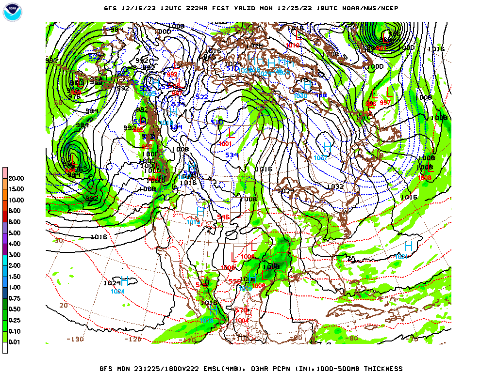
Then for Christmas the GFS would make me inclined to trim the rain chance back a little.

While the ECMWF would really increase it. If I had to make a forecast here I'd go with a 30% chance of rain considering the model madness.


And the mess continues on Tuesday, the day after Christmas.
With the ECMWF having a different timing and placemen of everything from the GFS.
And seeing just what a mess this is, I'm going to refrain from the 10-Day-Forecast I had planned on. Wait until Christmas gets within the 7-Day range. It's not worth throwing a forecast up there when confidence is this low.

Rainfall amounts for this forecast period should stay light, probably less than a quarter-inch for most of us. The heavier rains ended up being focused on Florida up through the Mid-Atlantic coastal region.
One National Weather Service forecaster mentioned today to remember the "Five P's" of cold weather safety: Protect people, pipes, pets, and plants . . . and Practice fire safety. Sounded like good advice to me.


No comments:
Post a Comment