(Forecast)
Friday (High 98, Low 71): Partly cloudy with isolated showers and thunderstorms possible. Very hot and humid.
Saturday (High 96, Low 72): Partly cloudy with isolated showers and thunderstorms possible. Hot and humid.
Sunday (High 94, Low 73): Partly cloudy with widely scattered showers and thunderstorms possible. Hot and humid.
(Extended Outlook)
Monday (High 91, Low 72): Partly cloudy with a 30% chance of showers/thunderstorms.
Independence Day (High 89, Low 70): Partly cloudy with a 40% chance of showers/thunderstorms.
Wednesday (High 88, Low 69): Partly cloudy with a 30% chance of showers/thunderstorms.
Thursday (High 89, Low 69): Partly cloudy with a 30% chance of showers/thunderstorms.
(Tea Leaves Territory)
Friday (High 88, Low 70): Partly cloudy with a 40% chance of showers/thunderstorms.
Saturday (High 89, Low 69): Partly cloudy with a 30% chance of showers/thunderstorms.
Sunday (High 91, Low 70): Partly cloudy with a 20% chance of showers/thunderstorms.
(Beach Forecast)
Friday (High 90, Low 80): Sunny.
Saturday (High 90, Low 79): Sunny.
Sunday (High 88, Low 80): Mostly sunny with an isolated shower or thunderstorm possible.
Monday (High 87, Low 78): Partly cloudy and breezy with widely scattered showers and thunderstorms possible.
Independence Day (High 87, Low 79): Partly cloudy and breezy with scattered showers and thunderstorms possible.
(Pronóstico)
Viernes (Alta 98, Baja 71): Parcialmente nublado con lluvias aisladas y posibles tormentas eléctricas. Muy caluroso y húmedo.
Sábado (Alta 96, Baja 72): Parcialmente nublado con lluvias aisladas y tormentas eléctricas posibles. Caliente y húmedo.
Domingo (máxima 94, mínima 73): Parcialmente nublado con posibles lluvias dispersas y tormentas eléctricas. Caliente y húmedo.
(Perspectiva extendida)
Lunes (Alta 91, Baja 72): Parcialmente nublado con un 30% de probabilidad de lluvias/tormentas eléctricas.
Día de la Independencia (Alta 89, Baja 70): Parcialmente nublado con un 40% de probabilidad de lluvias/tormentas eléctricas.
Miércoles (Alta 88, Baja 69): Parcialmente nublado con un 30% de probabilidad de lluvias/tormentas eléctricas.
Jueves (Alta 89, Baja 69): Parcialmente nublado con un 30% de probabilidad de lluvias/tormentas eléctricas.
(Territorio de las hojas de té)
Viernes (Alta 88, Baja 70): Parcialmente nublado con un 40% de probabilidad de lluvias/tormentas eléctricas.
Sábado (Alta 89, Baja 69): Parcialmente nublado con un 30% de probabilidad de lluvias/tormentas eléctricas.
Domingo (Alta 91, Baja 70): Parcialmente nublado con un 20% de probabilidad de lluvias/tormentas eléctricas.
(Pronóstico de la playa)
Viernes (Alta 90, Baja 80): Soleado.
Sábado (Alta 90, Baja 79): Soleado.
Domingo (Alta 88, Baja 80): Mayormente soleado con una lluvia aislada o tormenta eléctrica posible.
Lunes (Alta 87, Baja 78): Parcialmente nublado y con brisa, con posibles lluvias dispersas y tormentas eléctricas.
Día de la Independencia (High 87, Low 79): Parcialmente nublado y con brisa, con lluvias dispersas y posibles tormentas eléctricas.
(Note)
The Spanish thing is just an experiment that might be more useful than the experiments with 10-day outlooks. If you find a mistake in it, or if you find a mistake of another kind (like in the meteorology), feel free to
send me an e-mail so that I can learn from the mistake.
(Discussion)
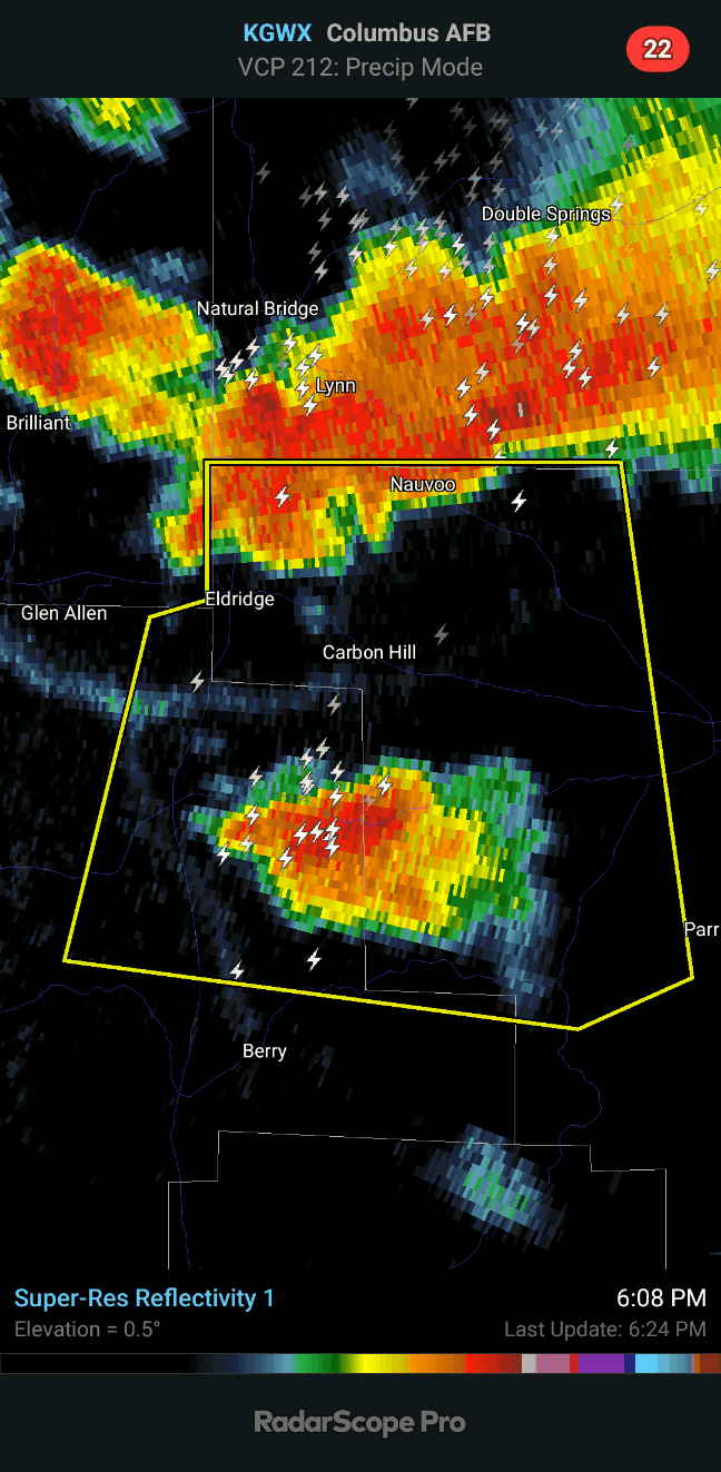
It was a mostly sunny day in the Tennessee Valley with some pretty decent heat. Here in the late afternoon, at 4:48 PM, we've got some thunderstorms moving through parts of the area from a mesoscale convective system that dropped down from Tennessee and Kentucky. Some of these storms have become severe and produced damaging wind gusts and golfball-sized hail in Tennessee, up around Lawrenceburg. Severe thunderstorms are currently moving through areas like Rogersville, Lexington, Town Creek, and Moulton. So folks to the Southeast in Morgan and Cullman Counties want to monitor the progress of these storms and take precautions later if necessary. Winston County might want to keep an eye on this cluster of storms too just in case it were to move more South than Southeast.

With the latest warning that has come out, we're back to the mention of golfball sized hail. For a while it was estimated to be down to quarter size. These storms have been some real hailers though, with the threat for damaging wind gusts being there but being secondary sometimes.


These storms do also contain a lot of lightning, which is only to be expected with this kind of heat. It hasn't gotten as hot as forecast today though. The humidity has made it feel like it's about 100 degrees for a lot of us anyway, but the temperatures have not been all that bad compared to what they were expected to be. The High in Cullman was 90 after a morning Low of 66. Jasper did make it up to 95 degrees, after a Low of 66 there too. And Haleyville also had a High of 95 and Low of 66. Now that's still hot. And with the humidity factored in, we saw some Heat Indices of 100-105. But so far this miniature heat wave is underperforming. We are still under a ridge of high pressure and then have that strong High pressure center at 500 millibars over the Sabine Valley/Ark-LA-Tex. You can see as that system continues to push East it is moving a warm front through our region.

And with this latest warning, it looks like we may be dealing with hail up to the size of baseballs. Please don't get caught out in these storms, whether outdoors or driving. This hail would be enough to break the windshield of a car. Especially if combined with strong winds up to 60 mph.
The exact track of these storms can change, summer storms, and right now they are moving more South than Southeast. Everyone from Double Springs to Cullman up to even places like Falkville and Hartselle need to be prepared in case you have to take cover from these storms as they move along.
It is 5:09 PM as I write this. This storm cluster is believed to be producing hail up to the size of baseballs and capable also of damaging wind gusts up to about 60 miles per hour. The best place to be is in a sturdy house, small room, lowest floor, near the center of the house, away from windows or anything electrical. But at minimum I'd get inside and stay away from windows or anything likely to conduct lightning. Might unplug things like a cell phone or laptop. And ahead of these storms, if you have time to safely do so, might put your car in the garage or parking deck. But your safety first, but if you can prevent hail damage to property, that is good too. I'll finish the forecast as time allows, but this weather is getting serious again.
If we get a warning for Winston or Cullman County, I'll post that separately and postpone this forecast.
All right, coming up on 6:30 now, and the storms are finishing moving through Walker and Fayette Counties. So until the next reissue of a warning, if we're going to have that for Walker, going to try to finish up this forecast.
And here's the new warning . . .
Which is not showing up on the easier graphics to insert here, but you can see the severe thunderstorms are moving into Fayette and Tuscaloosa counties.
Now let's look at computer modelling as far as what to expect this weekend and into the 4th of July and beyond.
Tomorrow is still expected to be our hottest day from this mini heat wave. But I don't think it's going to be as hot as earlier forecasts suggested. We expected to be in the upper 90's today and only made 90 for Cullman, 95 for Jasper and Haleyville. So I'm going to forecast a High of 98 degrees instead of 100 for tomorrow. Low should be about 72. Chance of a shower or thunderstorm only 20%. If somebody does get a rogue storm, it could be strong, but usually they don't produce golfball sized hail like we saw today. The hail is usually quarter-sized or smaller if it happens this time of year. This was from a mesoscale convective system. The models did pick up on that but had the timing for Wednesday or Wednesday night. So the basic idea was right after all, just a day too early.


On Saturday again the chance of rain or a thunderstorm bringing relief from the heat/humidity is minimal. But we have less of a clearly defined "heat bubble", upper-level High as much as we are just under a ridge around here, pretty strong ridge. Should see a High of more like 96-97, Low still in lower 70's.
Sunday looks similar as far as rain chances, but some earlier guidance was showing an increase, so may bump rain chance up to 30% here. The upper-level pattern starts to relax so that we can drop into the lower 90's again. And again a Low in the lower 70's.
Then for Monday, with the upper-level winds shifting back to the West/Southwest, a rain chance of 30% looks reasonable. High should be near 90, Low near 70.
Then by the 4th of July, a cold front will push into the region and probably stall out before it washes out. Looks like need to include a 40% rain chance here, but that's still scattered rain and thunderstorms. So when making your plans, if you are celebrating here locally instead of heading down to the beach, just make sure everybody has a place to get inside in case there is a passing shower or thunderstorm, and it should be fine. Not expecting any excessive heat like this weekend, in fact the High will probably dip into the upper 80's.
Then for Wednesday, will trim the rain chance back to 30%.
Because fronts this time of year tend to get hung up or dissipate over our region.
Still expecting a High in the upper 80's, Low in the upper 60's.
Looking at model trends, will keep that 30% chance of rain in there for next Thursday.
Beyond that, it's almost like reading tea leaves. But just for fun, I try that about once a week, since so many television stations do that now. It seems to go in and out of style, and I wouldn't doubt it's a promotional thing the TV stations do that the meteorologists have little or no say in, at least with some stations. Maybe in the summertime, there is some skill in forecasts at this long range. But even when I'm the one doing it, I feel obliged to tell you that beyond about a week in advance, forecasts can get pretty dubious in a hurry. But next Friday looks like need to increase the rain chance to 40%. Back to 30% for Saturday. Then for Sunday back to 20%. And temperatures will probably warm back to about 90 or so for High, 70 for Low, by Sunday.

There is a surface trough producing disorganized showers and storms a few hundred miles South/Southeast of Bermuda. It is moving North slowly at about 5-10 miles per hour. And the upper-level winds are strong enough that it probably is not going to develop into anything, even over the next week.
We do have a couple of tropical cyclones in the Eastern Pacific.
Hurricane Adrian is producing swells along the Southwestern/Western coasts of Mexico and the Baja California Peninsula, which makes for dangerous rip currents. It is expected to slowly weaken as it moves into cooler waters and drier air between now and Monday, and will probably dissipate over open water early next week.
Much more concerning is Tropical Storm Beatriz. Expected to become a hurricane by tomorrow (Friday). This has prompted a Hurricane Warning for the coasts of Guerrero, Michoacan, Colima, and Jalisco. Friday and Saturday could be rough for some of those folks down that way.
And in Southern Mexico, from Oaxaca back West to Jalisco, heavy rainfall is expected that could lead to flash flooding and mudslides, even in areas not affected directly by the Hurricane Warning.
Around here, we could see an average of about an inch or two of rain over the next week, maybe an isolated higher amount closer to three inches, at least in Northeast Alabama up into Tennessee, where any leftovers from any more of those MCS's up North are more likely to produce any rain or thunderstorms in the coming days.
Thanks for reading. Stay cool.