(Forecast)
Monday (High 87, Low 69): Partly cloudy. Widely scattered showers and thunderstorms are possible.
Tuesday (High 84, Low 68): Partly cloudy. Widely scattered showers and thunderstorms are possible.
Wednesday (High 84, Low 65): Mostly sunny. Mild with low humidity.
(Extended Outlook)
Thursday (High 83, Low 62): Mostly sunny.
Friday (High 85, Low 64): Mostly sunny.
Saturday (High 88, Low 66): Sunny.
Sunday (High 90, Low 68): Sunny.
(Beach Forecast - Gulf Shores)
Monday (High 89, Low 82): Thunderstorms likely.
Tuesday (High 88, Low 78): Thunderstorms.
Wednesday (High 89, Low 77): Thunderstorms likely.
Thursday through Sunday (Highs in upper 80's, Lows near 80): Partly cloudy with a 40% chance of showers/thunderstorms.
Hurricane Idalia will be close enough to cause a potential for hazardous rip currents and dangerous surf conditions.
(Pronóstico)
Lunes (Máxima 87, Mínima 69): Parcialmente nublado. Es posible que se produzcan lluvias y tormentas eléctricas ampliamente dispersas.
Martes (Máxima 84, Mínima 68): Parcialmente nublado. Es posible que se produzcan lluvias y tormentas eléctricas ampliamente dispersas.
Miércoles (Máxima 84, Mínima 65): Mayormente soleado. Templado con poca humedad.
(Perspectiva Extendida)
Jueves (Máxima 83, Mínima 62): Mayormente soleado.
Viernes (Máxima 85, Mínima 64): Mayormente soleado.
Sábado (Máxima 88, Mínima 66): Soleado.
Domingo (Máxima 90, Mínima 68): Soleado.
(Pronóstico de la Playa - Gulf Shores)
Lunes (Máxima 89, Mínima 82): Probabilidad de tormentas eléctricas.
Martes (Máxima 88, Mínima 78): Tormentas eléctricas.
Miércoles (Máxima 89, Mínima 77): Probabilidad de tormentas eléctricas.
De Jueves a Domingo (Máximas en los 80 grados superiores, Mínimas cerca de 80): Parcialmente nublado con un 40 % de probabilidad de lluvias/tormentas eléctricas.
El huracán Idalia estará lo suficientemente cerca como para causar la posibilidad de que se produzcan corrientes de resaca peligrosas y condiciones de oleaje peligrosas.
Overall we had a partly to mostly sunny day in the area. The High in Cullman was 90 after a morning Low of 70. Winds have generally shifted around to the North/Northwest and stayed pretty light. Jasper got up to 93 today, also a Low of 70 there. High was 89, Low of 70 in Haleyville. So our heat wave is over now. These are more seasonable temperatures, and we have milder, drier air on the way.
We have some showers and thunderstorms across the map again, but they are staying pretty isolated.
The heavier rains are mainly over the Carolinas, some fairly organized rain in Georgia too. They have had isolated flooding issues up there in the Mid-Atlantic region. Very isolated instances of damaging winds in some thunderstorms in the Southeast today but mainly in Georgia, not in Alabama or Tennessee. The front has already cleared the area and is down around Mobile, but stretches through about Atlanta and up into the Carolinas and then into the Atlantic.
Even though the front is well to our South now, the Low pressure system associated with it and some good Southwest flow from the Gulf waters will bring us some chance of a few showers and thunderstorms across the region tomorrow.

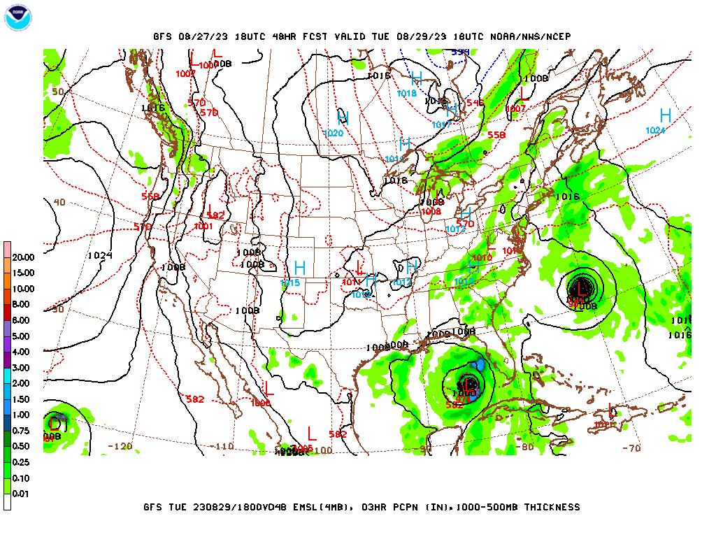
The NAM wants to bring us more coverage of rain than the GFS. Around here I think a 30% chance of rain is a good estimate, just widely scattered showers or thunderstorms across the map. Of course with it being late summer, always a low risk of a thunderstorm pulsing up and producing some microburst winds somewhere, but overall just looking at regular rain and thunderstorms. And a lot of us should stay dry through the day, this is only a 3 in 10 chance of getting a shower or storm. Of course we've got Hurricane Franklin in the Atlantic, and we've got Hurricane Idalia (currently still Tropical Storm Idalia) affecting Western Cuba as it keeps moving up into the Gulf of Mexico up toward Florida. Temperatures around here will be somewhat milder. Looking for a High near 87, a Low near 69.


Then on Tuesday, basically the same thing, except temperatures more toward the lower 80's, Low still in upper 60's. Of course all eyes are on Hurricane Idalia. And I am confident that it will be a hurricane by Tuesday. This thing is expected to intensify rapidly over the waters of the Gulf of Mexico, where last I checked, the average water temperature was about 90 degrees. I don't think the moderate vertical wind shear will keep it from strengthening.
And the NAM again has a little more of a rain chance, and I'm mainly showing it for the slightly different placement of the hurricane, a little farther to the West.
While the ECMWF has it farther East. If this guidance were to verify, it'd be more an issue for South Florida. Like even if it makes landfall farther North, this is a close shave with what could be a powerful hurricane, where there on its East side, South Florida could feel some impacts. This is only one model, and of course, have to consider all the models together and use some sense before making a forecast. That's why we have the National Hurricane Center in Miami, to sort these things out better than the rest of us.


By Wednesday the remnants of the hurricane are moving through Georgia, mainly East/Southeast Georgia. And the weather could be really rough there, with potential for flash flooding, high winds, and isolated tornadoes. Especially if this thing intensifies rapidly before landfall, then the people who get hit inland may still have some decent impacts. Around here we are on the Northwest side, the dry side.
And the European solution is similar, but has the tropical cyclone displaced a little farther to the East. Its track has trended a little further South and East than most other models. So that's something to keep in mind. It did pick up on this before any other models, based on what I remember seeing. And I think the first time I saw it showing that, I thought it was just a junk run showing a crazy scenario. But sometimes this model picks up on tropical stuff before any of the others. And it looks like that has happened again.
So around here for Wednesday, we should be clearing out, mostly sunny skies again, but with really mild temperatures. High may be down in the lower 80's, and the Low in the mid-60's. I guess we could still see an isolated shower or two early in the morning, but I doubt it. Combination of the low pressure system moving along and us being on the dry side of a landfalling hurricane, I think Wednesday is going to be dry.
Then on Thursday, looking at a High in the lower 80's and Low in the lower 60's. Doubt we see any rain, skies should be mostly sunny. You can always get an isolated shower in the summertime here. But chances are minimal. If we did see anything, it'd be from simple things like air rising up a mountain or off a body of water and forming some clouds and rain.
Skies should stay mostly sunny Friday as well, with a High in the mid-80's and Low in mid-60's.
Then on Saturday the strong upper-level High starts to expand toward our region again. Which will bring the High back up into the upper 80's, Lows may start to edge back into the upper 60's again. Expecting sunshine.
Then Sunday the high pressure shifts a little bit but still is in a good position to bring us sunny skies, a High near 90 and a Low again in the upper 60's.
Hurricane Franklin is expected to pass North and West of the Island of Bermuda on Wednesday. It is expected to be at major hurricane strength, with winds of about 115 knots, or 130 miles per hour. So this is a close shave for the island even if the eyewall stays well offshore, Impacts can extend pretty far on that Eastern side of it. And they have excellent preparedness and shelters available in Bermuda. Hats off to them for that.


Tropical Storm Idalia should become Hurricane Idalia by some time tomorrow or tomorrow night. The Gulf waters are ideal for a hurricane to form and rapidly intensify. It has already prompted a
Hurricane Watch for a good chunk of the Florida coast, mainly along the Western side of the Peninsula. And my personal gut feeling is that this has the potential to be a hurricane with significant impacts. Sometimes the computer models do not pick up on that as well as a human forecaster who can sort of recognize patterns and "feel" it. This one could get really nasty for whoever gets the most direct impacts. Landfall will probably be somewhere between about Tallahassee and Orlando and will probably take place Tuesday night or Wednesday morning. So people really do not have much time to get ready for this one. Everybody in the path of this, the path of that cone shown above from the Hurricane Center, needs to take their hurricane precautions, whether they can safely shelter in place or need to move farther inland, to a shelter or to stay with some family or friends with a safe enough place, or who are far away enough from the places that will be hardest hit. As of right now, it is mainly an issue for Western Cuba, with only tropical storm conditions expected there and back to places like Cozumel and other parts of the Yucatan Peninsula of Mexico. Even though it is only tropical storm strength down there, it is hazardous, because they have to think about things like mudslides with their mountainous terrain. But things look somewhat ominous for Florida, after this system has time to strengthen over the waters of the Gulf of Mexico. And I think it will strengthen rapidly tomorrow into Tuesday, then make landfall Tuesday night or Wednesday morning. It would not be out of the question to see this ramp up to a major hurricane, although that is not in the current forecast. Whether that happens or not, this setup just doesn't look good to me. Even if the impacts are more from a storm surge, or from flooding issues, or tornadoes forming in those spiral bands on the East/Northeast side of the hurricane, this just has the look and feel of a hurricane that whoever gets the worst of it will remember. To be considered a major hurricane, the sustained winds would have to be at least 96 knots, or 111 miles per hour. We may not see that, and it could stay at a Category One, but I really do not trust this setup. It looks dangerous.

Around here, rainfall amounts will probably only be about an inch or less for this forecast period. The really heavy rains will of course be along and just East of the track of Hurricane Idalia. And those places have a risk for issues with flooding. Like I say, between the heavy rains and hurricane winds, I think this storm has the potential for significant impacts, especially where the eyewall does make landfall. It just doesn't look so good. And hopefully people in the path will go ahead and take their precautions before it is bearing down on them.


No comments:
Post a Comment