Saturday, September 30, 2023

Mild Dry Pattern Continues, Cooler Temperatures Next Weekend

(Forecast)

Sunday (High 85, Low 61): Mostly sunny. Mild.

Monday (High 84, Low 60): Mostly sunny. Mild.

Tuesday (High 83, Low 59): Sunny. Mild.

(Extended Outlook)

Wednesday (High 82, Low 60): Mostly sunny.

Thursday (High 81, Low 61): Partly cloudy. 

Friday (High 79, Low 60): Partly cloudy with a 20% chance of showers.

Saturday (High 75, Low 54): Mostly sunny. 

(Beach Forecast)

Sunday (High 88, Low 70): Sunny and breezy.

Monday (High 85, Low 70): Sunny. 

Tuesday and Wednesday (High 84-85, Low 68): Sunny.

Thursday and Friday (High in mid-80's, Low in upper 60's): Partly cloudy with a 20% chance of showers/thunderstorms. 

Saturday (High ~85, Low ~67): Partly to mostly sunny. 

(Pronóstico)

Domingo (Máxima 85, Mínima 61): Mayormente soleado. Leve.

Lunes (Máxima 84, Mínima 60): Mayormente soleado. Leve.

Martes (Máxima 83, Mínima 59): Soleado. Leve.

(Perspectiva Extendida)

Miércoles (Máxima 82, Mínima 60): Mayormente soleado.

Jueves (Máxima 81, Mínima 61): Parcialmente nublado.

Viernes (Máxima 79, Mínima 60): Parcialmente nublado con un 20 % de probabilidad de lluvias.

Sábado (Máxima 75, Mínima 54): Mayormente soleado.

(Pronóstico de la Playa)

Domingo (Máxima 88, Mínima 70): Soleado y ventoso.

Lunes (Máxima 85, Mínima 70): Soleado.

Martes y Miércoles (Máxima 84-85, Mínima 68): Soleado.

Jueves y Viernes (Máxima a mediados de los 80, mínima en los 60 superiores): Parcialmente nublado con un 20 % de probabilidad de lluvias/tormentas eléctricas.

Sábado (Máxima ~85, Mínima ~67): Parcialmente a mayormente soleado.

Friday, September 29, 2023

Plenty of Sunshine and Mild Temperatures for a While

(Forecast)

Friday (High 85, Low 60): Sunny. Mild.

Saturday (High 86, Low 60): Sunny. Mild.

Sunday (High 85, Low 61): Mostly sunny. Mild.

(Extended Outlook)

Monday (High 84, Low 62): Mostly sunny.

Tuesday (High 83, Low 58): Mostly sunny.

Wednesday (High 82, Low 60): Partly cloudy.

Thursday (High 80, Low 60): Partly cloudy with a 20% chance of showers.

(Tea Leaves Territory)

Friday (High 80, Low 61): Partly cloudy with a 20% chance of showers. 

Saturday (High 78, Low 59): Mostly sunny.

Sunday (High 76, Low 54): Mostly sunny.

(Pronóstico)

Viernes (Máxima 85, Mínima 60): Soleado. Leve.

Sábado (Máxima 86, Mínima 60): Soleado. Leve.

Domingo (Máxima 85, Mínima 61): Mayormente soleado. Leve.

(Perspectiva Extendida)

Lunes (Máxima 84, Mínima 62): Mayormente soleado.

Martes (Máxima 83, Mínima 58): Mayormente soleado.

Miércoles (Máxima 82, Mínima 60): Parcialmente nublado.

Jueves (Máxima 80, Mínima 60): Parcialmente nublado con un 20 % de probabilidad de lluvias.

(Territorio de las Hojas de Té)

Viernes (Máxima 80, Mínima 61): Parcialmente nublado con un 20 % de probabilidad de lluvias.

Sábado (Máxima 78, Mínima 59): Mayormente soleado.

Domingo (Máxima 76, Mínima 54): Mayormente soleado.

(Notes)

The National Weather Service in Birmingham is offering SKYWARN classes ahead of our November peak in severe weather. They are also having Open House on October 14th. 

(Discussion)


Rain has been scarce in the region lately. Overall we had a sunny day in the Tennessee Valley with only a few passing clouds at times. A few isolated spots saw a few raindrops, but that's been few and far between lately. The High in Cullman was 81 with a Low of 63 this morning. Jasper got all the way up to 86 but was cooler in the morning, Low of 57 down there. Fort Payne had a High of 82 and Low of 61. Muscle Shoals saw a High of 86 and a Low of 63. Almost forgot Haleyville in the shuffle there, they had a High of 85, Low of 61. Huntsville had a High of 85 and Low of 62 today. Decatur saw a High of 84, Low of 61. Gadsden saw a High of 82, Low of 59. 

Elsewhere around the region, Birmingham had a High of 83 after a morning Low of 65. Atlanta only got up to 77 today after a morning Low of 61. They did have a lot of cloud cover through the day. Nashville was actually one of the places that got some rain and even some thunder earlier today, High of 71 and Low of 65 there. By contrast, Memphis had mostly sunny skies and 91 degrees, morning Low of 71. And over in Tupelo, they got up to 88, morning Low of 68, under sunny skies. 


High pressure will settle into the region tomorrow, and skies will be sunny, not expecting any rain and not many clouds either, High near 85, overnight Low near 60.


If anything the air gets drier over the weekend as the ridge of high pressure amplifies. We'll see sunny skies with a High of about 85 or 86, Low down around 60. 


On Sunday it looks like the core of the high pressure will shift up into the Great Lakes region. Around here, once again mostly sunny skies with a High in the mid-80's and a Low around 60 or so. 


Then in the extended period, on Monday the high pressure center moves into New England. Should stay mostly sunny down here, and guidance is showing a slight decrease in temperatures, maybe more toward lower 80's on Monday for the High, the Low still about the same, lower 60's.


We will be between the ridge and a trough to the West going into Tuesday, and looks like we may get a shot of drier air overnight between Monday and Tuesday, which would allow Lows to fall into the upper 50's, still expecting a High in the lower 80's.


Could see at least a slight increase in clouds as that trough approaches on Wednesday. Low probably near 60, and the High again only making it into the lower 80's.


It may be Thursday before that trough drags a front into our region again. And even this you see from the GFS, the ECMWF was not as aggressive with it, as is often the case. Might reintroduce a 20% chance of rain here with a High near 80, Low near 60. Or may leave the rain chance out since only the GFS shows it and the overall pattern is dry. And this is Day 7. 

Let's peek at Days 8-10 just for fun. 


The GFS shows a swift frontal passage on Friday, while the ECWMF does not, times the front coming through the area more on Friday. So in light of this, reasonable to blanket both days with a 20% rain chance. High should stay around 80, Low near 60. 


Then on Saturday there is decent agreement in drier air moving back in here, and behind that front, could see temperatures cool a few degrees anyway, not sure how far we might dip into 70's on Saturday, but at least the morning might be slightly drier and cooler, back into upper 50's.


Then on Sunday the 8th of October, looks like mostly sunny skies and a High probably in mid/upper 70's, Low down in 50's, maybe our first real taste of Fall weather. 

But please understand that beyond seven days, even in a calm pattern like this, the confidence drops off sharply. I noticed one of the better television stations has dropped their 10-Day outlooks, and I may soon follow suit. Even when I was keeping up this blog regularly, I only tried one about once a week. I guess you can get away with it in the summer time. Overall I'd rather be more honest and above-board with people who visit this blog. That's why I call it the land of tea leaves sometimes, because beyond 7 days out, you're looking at general trends at best usually. Yeah, even in a summer pattern. 


We do have a couple of tropical storms in the Atlantic. 


Tropical Storm Philippe is expected to remain over open water.


And Tropical Storm Rina is not posing any threat to land either. 


So the weather is pretty calm right now. If we do see any rain over the next 7-10 days, it will probably be very light, about a ten of an inch or less, and more likely to be focused on our western counties. 

Friday, September 22, 2023

Tropical Storm Ophelia


So while I've been out of the weather loop lately, it looks like that model guidance roughly a week ago turned out to be right, and parts of the East Coast can expect some tropical storm impacts. 

 000

WTNT31 KNHC 221751

TCPAT1


BULLETIN

Tropical Storm Ophelia Intermediate Advisory Number 5A

NWS National Hurricane Center Miami FL       AL162023

200 PM EDT Fri Sep 22 2023


...CYCLONE BECOMES TROPICAL STORM OPHELIA... 

...TROPICAL STORM CONDITIONS CONTINUING ACROSS COASTAL PORTIONS OF 

NORTH CAROLINA...


SUMMARY OF 200 PM EDT...1800 UTC...INFORMATION

----------------------------------------------

LOCATION...32.7N 76.0W

ABOUT 150 MI...240 KM SE OF CAPE FEAR NORTH CAROLINA

ABOUT 185 MI...295 KM S OF CAPE HATTERAS NORTH CAROLINA

MAXIMUM SUSTAINED WINDS...60 MPH...95 KM/H

PRESENT MOVEMENT...NNW OR 345 DEGREES AT 12 MPH...19 KM/H

MINIMUM CENTRAL PRESSURE...992 MB...29.29 INCHES


WATCHES AND WARNINGS

--------------------

CHANGES WITH THIS ADVISORY:


None.


SUMMARY OF WATCHES AND WARNINGS IN EFFECT:


A Storm Surge Warning is in effect for...

* Beaufort Inlet, North Carolina to Chincoteague, Virginia

* Chesapeake Bay south of Colonial Beach, Virginia

* Neuse and Pamlico Rivers

* Portions of Pamlico and Albemarle Sounds


A Tropical Storm Warning is in effect for...

* Cape Fear, North Carolina to Fenwick Island, Delaware

* Albemarle and Pamlico Sounds

* Tidal Potomac south of Cobb Island

* Chesapeake Bay south of North Beach


A Storm Surge Watch is in effect for...

* Surf City, North Carolina to Beaufort Inlet, North Carolina

* Remainder of Pamlico and Albemarle Sounds


A Storm Surge Warning means there is a danger of life-threatening

inundation, from rising water moving inland from the coastline,

during the next 36 hours in the indicated locations. For a depiction

of areas at risk, please see the National Weather Service Storm

Surge Watch/Warning Graphic, available at hurricanes.gov.  This is a

life-threatening situation.  Persons located within these areas

should take all necessary actions to protect life and property from

rising water and the potential for other dangerous conditions.

Promptly follow evacuation and other instructions from local

officials.


A Tropical Storm Warning means that tropical storm conditions are

expected somewhere within the warning area.


A Storm Surge Watch means there is a possibility of life-

threatening inundation, from rising water moving inland from the

coastline, in the indicated locations during the next 48 hours.

For a depiction of areas at risk, please see the National Weather

Service Storm Surge Watch/Warning Graphic, available at

hurricanes.gov.


For storm information specific to your area, including possible

inland watches and warnings, please monitor products issued by your

local National Weather Service forecast office.


DISCUSSION AND OUTLOOK

----------------------

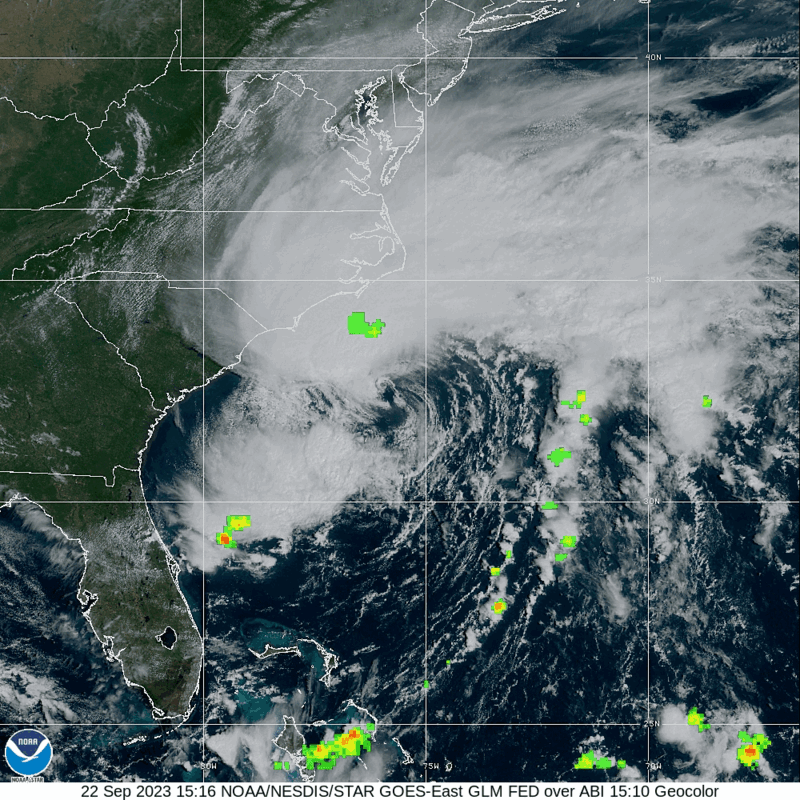
At 200 PM EDT (1800 UTC), the center of Tropical Storm Ophelia was 

located near latitude 32.7 North, longitude 76.0 West. Ophelia is 

moving toward the north-northwest near 12 mph (19 km/h). This 

general motion is expected to continue during the next day or so, 

followed by a slight turn toward the north. On the forecast track, 

the center of Ophelia will approach the coast of North Carolina 

tonight, and then move across eastern North Carolina, southeastern 

Virginia, and the Delmarva Peninsula Saturday and Sunday.


Data from the Air Force Reserve Hurricane Hunters and satellite wind 

data indicate that maximum sustained winds have increased to near 60 

mph (95 km/h) with higher gusts. Some slight strengthening is 

possible before landfall along the coast of North Carolina.


Tropical-storm-force winds extend outward up to 275 miles (445 km) 

from the center. NOAA buoy 41025 at Diamond Shoals, North Carolina, 

recently reported a sustained wind of 47 mph (76 km/h) and a gust of 

60 mph (97 km/h). A NOAA C-MAN station at Cape Lookout, North 

Carolina, recently reported a sustained wind of 45 mph (72 km/h) and 

a gust of 52 mph (83 km/h).  


The estimated minimum central pressure is 992 mb (29.29 inches).


HAZARDS AFFECTING LAND

----------------------

Key messages for Ophelia can be found in the Tropical Cyclone

Discussion under AWIPS header MIATCDAT1, WMO header WTNT41 KNHC,

and on the web at hurricanes.gov/text/MIATCDAT1.shtml


STORM SURGE:  The combination of a dangerous storm surge and the

tide will cause normally dry areas near the coast to be flooded by

rising waters moving inland from the shoreline.  The water could

reach the following heights above ground somewhere in the indicated

areas if the peak surge occurs at the time of high tide...


Neuse and Bay Rivers...3-5 ft

Pamlico and Pungo Rivers...3-5 ft

Chesapeake Bay south of Colonial Beach...2-4 ft

Surf City, NC to Chincoteague, VA...2-4 ft

Albemarle Sound...2-4 ft

South Santee River, SC to Surf City, NC...1-3 ft

Chincoteague, VA to Manasquan Inlet, NJ...1-3 ft

Upper Chesapeake Bay...1-3 ft

Delaware Bay...1-3 ft


The deepest water will occur along the immediate coast in areas of

onshore winds, where the surge will be accompanied by dangerous

waves.  Surge-related flooding depends on the relative timing of the

surge and the tidal cycle, and can vary greatly over short

distances.  For information specific to your area, please see

products issued by your local National Weather Service forecast

office.


WIND:  Tropical storm conditions are affecting portions of the North 

Carolina coast within the warning area and will continue spreading 

northward through Saturday.


RAINFALL:  Ophelia is forecast to produce 3 to 5 inches of rainfall, 

with localized amounts of 7 inches across portions of eastern North 

Carolina and southeast Virginia from today into Saturday. Across 

remaining portions of the Mid-Atlantic into southern New England, 2 

to 4 inches of rainfall are forecast from later today into Sunday.  

This rainfall may produce flash, urban, and small stream flooding 

impacts.


SURF:  Swells generated by Ophelia will affect much of the east

coast of the United States through this weekend.  These swells are

likely to cause life-threatening surf and rip current conditions.

Please consult products from your local weather office.


TORNADOES:  A few tornadoes are possible beginning tonight through

Saturday for portions of the mid-Atlantic Coast.


NEXT ADVISORY

-------------

Next complete advisory at 500 PM EDT.


$$

Forecaster Reinhart


000

WTCA41 TJSJ 221810

TCPSP1


BOLETÍN

Tormenta Tropical Ophelia Advertencia Intermedia Número 5A

Centro Nacional de Huracanes del SNM Miami FL    AL162023

Traducción por el SNM San Juan PR

200 PM EDT viernes 22 de septiembre de 2023


...CICLÓN SE CONVIERTE EN TORMENTA TROPICAL OPHELIA...

...CONDICIONES DE TORMENTA TROPICAL CONTINUANDO A TRAVÉS DE SECTORES 

COSTEROS DE CAROLINA DEL NORTE...  


RESUMEN DE LAS 200 PM EDT...1800 UTC...INFORMACIÓN

----------------------------------------------

LOCALIZACIÓN...32.7N 76.0O

ALREDEDOR DE 150 MI...240 KM SE DE CAPE FEAR CAROLINA DEL NORTE

ALREDEDOR DE 185 MI...295 KM S DE CAPE HATTERAS CAROLINA DEL NORTE

VIENTOS MÁXIMOS SOSTENIDOS...60 MPH...95 KM/H

MOVIMIENTO ACTUAL...NO O 345 GRADOS A 12 MPH...19 KM/H

PRESIÓN CENTRAL MÍNIMA...992 MB...29.29 PULGADAS


VIGILANCIAS Y AVISOS

--------------------

CAMBIOS CON ESTA ADVERTENCIA:


Ninguno.


RESUMEN DE VIGILANCIAS Y AVISOS EN EFECTO:


Un Aviso de Marejada Ciclónica está en efecto para...

* Beaufort Inlet, Carolina del Norte hasta Chincoteague, Virginia

* Chesapeake Bay al sur de Colonial Beach, Virginia

* Río Neuse y Río Pamlico

* Porciones de Pamlico y Albemarle Sounds


Un Aviso de Tormenta Tropical está en efecto para...

* Cape Fear, Carolina del Norte hasta Fenwick Island, Delaware

* Albemarle y Pamlico Sounds

* Marea Potomac al sur de Cobb Island

* Chesapeake Bay al sur de North Beach


Una Vigilancia de Marejada Ciclónica está en efecto para...

* Surf City, Carolina del Norte hasta Beaufort Inlet, Carolina del 

Norte

* Resto de Pamlico y Albemarle Sounds


Un Aviso de Marejada Ciclónica significa que hay un peligro de 

inundación que amenace la vida, por el aumento del agua que se mueve 

tierra adentro desde la costa, durante las próximas 36 horas en los 

lugares indicados.  Para una representación de las áreas bajo 

riesgo, favor de consultar el Gráfico de Vigilancia/Aviso de 

Marejada Ciclónica del Servicio Nacional de Meteorología, disponible 

en hurricanes.gov.Esta es una situación que amenaza la vida. Las 

personas localizadas dentro de estas áreas deben tomar todas las 

acciones necesarias para proteger la vida y la propiedad del aumento 

del agua y el potencial de otras condiciones peligrosas.  Siga con 

prontitud las instrucciones de desalojo y otras de los oficiales 

locales.


Un aviso de tormenta tropical significa que se esperan condiciones 

de tormenta tropical en algún punto dentro del área bajo aviso.


Una Vigilancia de Marejada Ciclónica significa que hay una 

posibilidad de inundación que amenace la vida, por el aumento del 

agua que se mueve tierra adentro desde la  costa, en los lugares 

indicados durante las próximas 48 horas.  Para una representación de 

las áreas bajo riesgo, favor de consultar el Gráfico de 

Vigilancia/Aviso de Marejada Ciclónica del Servicio Nacional de 

Meteorología, disponible en hurricanes.gov.


Para información específica para su área, favor monitorear los 

productos emitidos por su oficina de servicio nacional de 

meteorología.


DISCUSIÓN Y PERSPECTIVAS

----------------------

A las 200 PM EDT (1800 UTC), el centro de la Tormenta Tropical 

Ophelia estaba  localizado cerca de la latitud 32.7 norte, longitud 

76.0 oeste.  Ophelia se está  moviendo hacia el norte-noroeste a 

cerca de 12 mph (19 km/h).  Se espera que este movimiento general 

continúe durante el próximo día más o menos,  seguido de un giro 

ligero hacia el norte.  En la trayectoria pronosticada, el centro de 

Ophelia se acercará a la costa de Carolina del Norte esta noche, y 

luego se moverá a través del este de Carolina del Norte, el sureste 

de Virginia y la Península de Delmarva el sábado y el domingo.


Los datos de los Cazahuracanes de la Reserva de la Fuerza Aérea y 

los datos de viento por satélite indican que los vientos máximos 

sostenidos han aumentado a cerca de 60  mph (95 km/h) con ráfagas 

más fuertes.  Es posible algún fortalecimiento ligero antes de tocar 

tierra a lo largo de la costa de Carolina del Norte.


Los vientos de intensidad de tormenta tropical se extienden hacia 

275 millas (445 km) mayormente del centro. La boya 41025 de NOAA en 

Diamond Shoals, Carolina del Norte, informó recientemente un viento 

sostenido de 47 mph (76 km/h) y una ráfaga de 60 mph (97 km/h).  Una 

estación de NOAA C-MAN en Cape Lookout, Carolina del Norte, informó 

recientemente un viento sostenido de 45 mph (72 km/h) y una ráfaga 

de 52 mph (83 km/h). 


La presión central mínima estimada es de 992milibares...29.29 

pulgadas.


PELIGROS AFECTANDO TIERRA

----------------------

Los mensajes clave para Ophelia se pueden encontrar en la Discusión 

de Ciclón Tropical bajo el encabezado MIATCDAT1 de AWIPS, encabezado 

WTNT41 KNHC, y en la web en hurricanes.gov/text/MIATCDAT1.shtml


MAREJADA CICLÓNICA: La combinación de una marejada ciclónica 

peligrosa y la marea causará que las áreas normalmente secas cerca 

de la costa se inunden por el aumento de las aguas que se mueven 

tierra adentro desde la costa.  El nivel del agua pudiera alcanzar 

la siguiente altura por encima del nivel de la superficie en algún 

lugar dentro de las áreas indicadas si el máximo de la marejada 

ocurre al mismo tiempo que la marea alta...


Neuse y Bay Rivers...3-5 pies 

Pamlico y Pungo Rivers...3-5 pies 

Chesapeake Bay al sur de Colonial Beach...2-4 pies 

Surf City, NC hasta Chincoteague, VA...2-4 pies 

Albemarle Sound...2-4 pies 

South Santee River, SC hasta Surf City, NC...1-3 pies 

Chincoteague, VA hasta Manasquan Inlet, NJ...1-3 pies 

Upper Chesapeake Bay...1-3 pies 

Delaware Bay...1-3 pies 


Las aguas más profundas ocurrían a lo largo de la costa inmediata en 

áreas donde los vientos soplan hacia tierra, donde la marejada será 

acompañada por olas grandes y destructivas. Las inundaciones 

relacionadas con las marejadas dependen del momento relativo de la 

marejada y el ciclo de la marea,  y pueden variar mucho en 

distancias cortas.  Para información específica en su área, favor de 

referirse a los productos emitidos por su oficina local de 

pronóstico del Servicio Nacional de Meteorología.


VIENTO: Las condiciones de tormenta tropical están afectando 

sectores de la costa de Carolina del Norte dentro del área bajo 

aviso y continuarán extendiéndose hacia el norte hasta el sábado.


LLUVIA: Se pronostica que Ophelia produzca de 3 a 5 pulgadas de 

lluvia, con cantidades localizadas de 7 pulgadas a través de 

sectores del este de Carolina del Norte y el sureste de Virginia 

desde hoy hasta el sábado.  A través de los sectores restantes del 

Atlántico Medio hasta el sur de Nueva Inglaterra, se pronostica de 2 

a 4 pulgadas de lluvia desde más tarde hoy hasta el domingo.   Esta 

lluvia puede producir impactos de inundaciones  repentinas, urbanas 

y de riachuelos pequeños.


OLEAJE: Las marejadas generadas por Ophelia afectarán gran parte de 

la costa este de los Estados Unidos hasta este fin de semana.  Es 

probable que estas marejadas causen condiciones de oleaje y 

corrientes marinas que amenacen la vida.  Favor de consultar los 

productos de su oficina local de meteorología.


TORNADOS: Algunos tornados son posibles comenzando esta noche hasta 

el sábado para sectores de la Costa del Atlántico medio.


PRÓXIMA ADVERTENCIA

-------------

Próxima advertencia completa a las 500 PM EDT.


$$

Pronosticador Reinhart


000

WTNT41 KNHC 221453

TCDAT1


Potential Tropical Cyclone Sixteen Discussion Number   5

NWS National Hurricane Center Miami FL       AL162023

1100 AM EDT Fri Sep 22 2023


Surface observations indicate the low pressure system off the 

southeast U.S. coast is deepening this morning. Recent pressure and 

wind data from NOAA buoy 41002 suggest the pressure has fallen to 

around 996 mb. While surface analyses indicate there is still a 

front in close proximity to the low, deep convection has become more 

concentrated to the north of the center. In fact, GOES-16 1-min 

visible imagery suggests the low-level center is re-forming closer 

to the convection. The broad wind field is asymmetric, with the 

strongest observed winds occurring to the north and west of the 

frontal feature. A NOAA Saildrone sampling the system reported a 

sustained wind of 40 kt and a gust around 50 kt earlier this 

morning. Based on the available observations, the initial intensity 

is held at 45 kt. An Air Force Reserve Hurricane Hunter aircraft is 

scheduled to investigate the system this afternoon.


The initial motion of the cyclone is just west of due north (350/10 

kt). The system is forecast to move north-northwestward to northward 

through Saturday along the west side of a subtropical ridge over the 

western and central Atlantic. This motion will take the center of 

the cyclone inland over eastern North Carolina on Saturday morning 

and over the Mid-Atlantic region Saturday night and Sunday. The 

track guidance is in good agreement for this forecast. Based on the 

slight northward adjustment to the initial position, the updated NHC 

forecast is slightly faster than the previous one, showing the 

cyclone center just inland in 24 h.


Based on recent satellite and observational trends, the cyclone 

appears likely to strengthen during the next 12 h over the warm Gulf 

Stream waters. The more organized convective structure should also 

facilitate its transition to a tropical storm during the next 6-12 h 

as it starts to become separated from its frontal features and 

develops a smaller inner core. The near-term intensity forecast has 

been bumped up slightly (55 kt) before the system moves inland early 

Saturday. After landfall, the system is expected to weaken due to 

the negative influences of land interaction, drier air, and strong 

upper-level winds. This forecast shows extratropical transition by 

48 h with dissipation by 72 h, in good agreement with the GFS and 

ECMWF models. 


Key Messages:


1. Tropical storm conditions are expected along portions of the 

southeastern and mid-Atlantic U.S. coasts within the Tropical Storm 

Warning area today into Saturday night.


2. There is a danger of life-threatening storm surge inundation

over portions of eastern North Carolina and southeastern Virginia,

including Pamlico and Albemarle Sounds, the Neuse and Pamlico 

Rivers, the lower James River, and the lower Chesapeake Bay, where 

Storm Surge Warnings are in place.  Residents in these areas should 

follow advice given by local officials.


3. Heavy rainfall from this system could produce flash, urban, and 

small stream flooding impacts across portions of the Mid-Atlantic 

states from North Carolina to New Jersey through Sunday.


4. Swells generated by this system will affect much of the U.S.

east coast through the weekend, likely causing life-threatening

surf and rip currents.


FORECAST POSITIONS AND MAX WINDS


INIT  22/1500Z 32.3N  75.6W   45 KT  50 MPH...POTENTIAL TROP CYCLONE

 12H  23/0000Z 33.2N  76.3W   55 KT  65 MPH...TROPICAL CYCLONE

 24H  23/1200Z 34.9N  76.8W   50 KT  60 MPH...INLAND

 36H  24/0000Z 36.8N  77.0W   40 KT  45 MPH...INLAND

 48H  24/1200Z 38.3N  77.0W   30 KT  35 MPH...POST-TROP/EXTRATROP

 60H  25/0000Z 39.3N  76.5W   25 KT  30 MPH...POST-TROP/EXTRATROP

 72H  25/1200Z...DISSIPATED


$$

Forecaster Reinhart

Saturday, September 16, 2023

Sunshine and Some Cool Mornings on the Way

(Forecast)

Sunday (High 80, Low 63): An isolated, lingering shower is possible in the morning. Becoming mostly sunny.

Monday (High 78, Low 56): Sunny. Mild and dry.

Tuesday (High 79, Low 54): Sunny. Mild and dry.

(Extended Outlook)

Wednesday (High 81, Low 57): Mostly sunny. 

Thursday (High 80, Low 59): Mostly sunny. 

Friday (High 81, Low 60): Mostly sunny.

Saturday (High 80, Low 61): Partly cloudy with a 20% chance of a shower or thunderstorm.

(Beach Forecast)

Sunday (High 87, Low 73): Mostly sunny with an isolated shower or thunderstorm possible.

Monday (High 89, Low 69): Sunny.

Tuesday through Rest of Week (Highs in upper 80's, Lows in upper 60's): Mostly sunny.

(Pronóstico)

Domingo (Máxima 80, Mínima 63): Es posible una lluvia aislada y persistente por la mañana. Volviéndose mayormente soleado.

Lunes (Máxima 78, Mínima 56): Soleado. Suave y seco.

Martes (Máxima 79, Mínima 54): Soleado. Suave y seco.

(Perspectiva Extendida)

Miércoles (Máxima 81, Mínima 57): Mayormente soleado.

Jueves (Máxima 80, Mínima 59): Mayormente soleado.

Viernes (Máxima 81, Mínima 60): Mayormente soleado.

Sábado (Máxima 80, Mínima 61): Parcialmente nublado con un 20 % de probabilidad de lluvia o tormenta eléctrica.

(Pronóstico de la Playa)

Domingo (Máxima 87, Mínima 73): Mayormente soleado con posible lluvia o tormenta aislada.

Lunes (Máxima 89, Mínima 69): Soleado.

De martes a resto de la semana (Máximas en los 80 grados superiores, Mínimas en los 60 grados superiores): Mayormente soleado.

Post-Tropical Cyclone Lee


000

WTNT33 KNHC 161453

TCPAT3


BULLETIN

Post-Tropical Cyclone Lee Advisory Number  45

NWS National Hurricane Center Miami FL       AL132023

1100 AM AST Sat Sep 16 2023


...LEE EXPECTED TO MAKE LANDFALL LATER TODAY...

...STRONG WINDS, COASTAL FLOODING, AND HEAVY RAINS ARE OCCURRING IN 

PORTIONS OF MAINE AND ATLANTIC CANADA...


SUMMARY OF 1100 AM AST...1500 UTC...INFORMATION

-----------------------------------------------

LOCATION...43.5N 66.2W

ABOUT 105 MI...170 KM SSE OF EASTPORT MAINE

ABOUT 150 MI...240 KM WSW OF HALIFAX NOVA SCOTIA

MAXIMUM SUSTAINED WINDS...75 MPH...120 KM/H

PRESENT MOVEMENT...N OR 350 DEGREES AT 22 MPH...35 KM/H

MINIMUM CENTRAL PRESSURE...965 MB...28.50 INCHES


WATCHES AND WARNINGS

--------------------

CHANGES WITH THIS ADVISORY:


Environment Canada has upgraded the Tropical Storm Watch to a

Tropical Storm Warning for Prince Edward Island, Magdalen Islands,

and portions of Nova Scotia and New Brunswick.


The Tropical Storm Warning has been discontinued from Westport, RI 

to Portsmouth, NH, including Martha's Vineyard and Nantucket.


SUMMARY OF WATCHES AND WARNINGS IN EFFECT:


A Hurricane Watch is in effect for...

* New Brunswick from the U.S./Canada border to Point Lepreau,

including Grand Manan Island

* Nova Scotia from Digby to Ecum Secum


A Tropical Storm Warning is in effect for...

* Portsmouth northward to the U.S./Canada border

* New Brunswick from the U.S./Canada border to Belledune,

including Grand Manan Island

* All of Nova Scotia

* Prince Edward Island

* Magdalen Islands


A Hurricane Watch means that hurricane conditions are possible

within the watch area, in this case later today.


A Tropical Storm Warning means that tropical storm conditions are

expected somewhere within the warning, in this case today through

Sunday.


For storm information specific to your area in the United

States, including possible inland watches and warnings, please

monitor products issued by your local National Weather Service

forecast office. For storm information specific to your area

outside of the United States, please monitor products issued by

your national meteorological service.


DISCUSSION AND OUTLOOK

----------------------

At 1100 AM AST (1500 UTC), the center of Post-Tropical Cyclone Lee

was located near latitude 43.5 North, longitude 66.2 West. The

post-tropical cyclone is moving toward the north near 22 mph (35

km/h). A northward motion is expected to continue, and the

center of Lee is forecast to make landfall near or just east of 

the U.S./Canada border this afternoon.  Lee is then expected to 

turn toward the northeast and move across Atlantic Canada tonight 

and Sunday.


Maximum sustained winds are near 75 mph (120 km/h) with higher

gusts.  Lee is expected to be at or just below hurricane strength

when it makes landfall later today.  Weakening is forecast

tonight and Sunday while Lee moves across Atlantic Canada.


Hurricane-force winds extend outward up to 140 miles (220 km) from

the center and tropical-storm-force winds extend outward up to 390

miles (630 km). A sustained wind of 51 mph (82 km/h) with a 

gust to 93 mph (150 km/h) was recently reported on Grand Manan 

Island in New Brunswick, Canada.  An observation in Eastport, 

Maine, recently reported 39 mph (63 km/h) sustained winds with a 

gust to 50 mph (81 km/h).  An observation in Lunenburg in Nova 

Scotia reported a sustained wind of 50 mph (81 km/h) and a wind 

gust of 66 mph (106 km/h).


The estimated minimum central pressure is 965 mb (28.50 inches).


HAZARDS AFFECTING LAND

----------------------

Key messages for Lee can be found in the Tropical Cyclone Discussion

under AWIPS header MIATCDAT3 and WMO header WTNT43 KNHC and on the

web at hurricanes.gov/text/MIATCDAT3.shtml


WIND:  Hurricane conditions are possible in the Hurricane Watch

areas in Atlantic Canada later today.  Tropical storm conditions

are occurring along the coasts of Maine and Nova Scotia and

will spread northward within the Tropical Storm Warning areas today

and tonight.  The strong winds are leading to downed trees

and power outages.  Tropical-storm-force gusts are likely to 

continue on Cape Cod for a couple of more hours.


SURF:  Swells generated by Lee are affecting the U.S. Virgin

Islands, Puerto Rico, Hispaniola, the Turks and Caicos Islands, the

Bahamas, Bermuda, the east coast of the United States, and Atlantic

Canada.  These swells are likely to cause life-threatening surf and

rip current conditions.  Please consult products from your local

weather office.


RAINFALL:  Through tonight, Lee is expected to produce rainfall 

amounts of 1 to 4 inches, or 25 to 100 millimeters over far eastern 

Massachusetts,  eastern Maine, western Nova Scotia, and New 

Brunswick. This could produce localized urban and small stream 

flooding.


STORM SURGE:  Water levels remain elevated along the New England 

Coast and will begin to subside after the next high tide cycle. For

information specific to your area, please see products issued by

your local National Weather Service forecast office.


A dangerous storm surge will produce coastal flooding within the

wind warning areas in Atlantic Canada in areas of onshore winds.

Near the coast, the surge will be accompanied by large and

destructive waves.


NEXT ADVISORY

-------------

Next intermediate advisory at 200 PM AST.

Next complete advisory at 500 PM AST.


$$

Forecaster Cangialosi


000

WTNT43 KNHC 161454

TCDAT3


Post-Tropical Cyclone Lee Discussion Number  45

NWS National Hurricane Center Miami FL       AL132023

1100 AM AST Sat Sep 16 2023


The core of Lee is very near the west coast of Nova Scotia.  Data 

from the NOAA Hurricane Hunters indicate that the minimum pressure 

has been steady at 965 mb, but the surface winds are down a little 

to 65 kt.  Dropsonde data indicate that winds are notably stronger 

just off the surface, so significant wind gusts are likely in areas 

of heavy rain and over elevated terrain near the coast.  In fact, an 

observation on Grand Manan Island in New Brunswick, Canada, recently 

recorded a wind gust of 81 kt (150 km/h).  Radar data from New 

England and Nova Scotia show bands of heavy rain onshore of portions 

of coastal New England and Atlantic Canada.  


Lee continues to accelerate northward and has jogged to the 

left this morning.  The core of the cyclone will likely brush the 

western portion of Nova Scotia during the next couple of hours and 

then move inland near or just east of the U.S./Canada border this 

afternoon.  After landfall, a faster northeastward motion is 

expected as a trough approaches the system, which should take Lee 

across portions of Atlantic Canada tonight and Sunday.


Little change in strength is expected before landfall, and the core 

winds are likely to come ashore in far down east Maine and western 

portions of New Brunswick.  Steady weakening is expected after Lee 

moves inland, and the system is expected to dissipate by late 

Monday.


KEY MESSAGES:


1. Hurricane conditions are possible across portions of southern New

Brunswick and Nova Scotia later today within the Hurricane Watch

areas.  Tropical storm conditions and coastal flooding are

occurring across portions of coastal Maine and Atlantic

Canada, and will continue to spread northward within the Tropical

Storm Warning areas.  The strong winds are already leading to downed

trees and power outages.


2. Heavy rainfall from Lee may produce localized urban and small 

stream flooding in portions of far eastern Massachusetts, eastern 

Maine, New Brunswick and western Nova Scotia today.


3. Dangerous surf and life-threatening rip currents will continue

to affect the U.S. East Coast, Atlantic Canada, Bermuda, the

Bahamas, the Turks and Caicos Islands, Hispaniola, Puerto Rico, the

Virgin Islands, and the northern Leeward Islands through the

weekend.


FORECAST POSITIONS AND MAX WINDS


INIT  16/1500Z 43.5N  66.2W   65 KT  75 MPH...POST-TROPICAL

 12H  17/0000Z 45.7N  65.8W   50 KT  60 MPH...POST-TROP/EXTRATROP

 24H  17/1200Z 48.3N  62.7W   40 KT  45 MPH...POST-TROP/EXTRATROP

 36H  18/0000Z 50.8N  57.1W   35 KT  40 MPH...POST-TROP/EXTRATROP

 48H  18/1200Z 53.0N  50.1W   35 KT  40 MPH...POST-TROP/EXTRATROP

 60H  19/0000Z...DISSIPATED


$$

Forecaster Cangialosi

Tropical Depression 15


000

WTNT35 KNHC 161455

TCPAT5


BULLETIN

Tropical Depression Fifteen Advisory Number   5

NWS National Hurricane Center Miami FL       AL152023

1100 AM AST Sat Sep 16 2023


...TROPICAL DEPRESSION EXPECTED TO STRENGTHEN THIS WEEKEND...


SUMMARY OF 1100 AM AST...1500 UTC...INFORMATION

-----------------------------------------------

LOCATION...19.7N 46.2W

ABOUT 1035 MI...1670 KM ENE OF THE LESSER ANTILLES

MAXIMUM SUSTAINED WINDS...35 MPH...55 KM/H

PRESENT MOVEMENT...NNW OR 330 DEGREES AT 18 MPH...30 KM/H

MINIMUM CENTRAL PRESSURE...1006 MB...29.71 INCHES


WATCHES AND WARNINGS

--------------------

There are no coastal watches or warnings in effect.


DISCUSSION AND OUTLOOK

----------------------

At 1100 AM AST (1500 UTC), the center of Tropical Depression Fifteen

was located near latitude 19.7 North, longitude 46.2 West. The

depression is moving toward the north-northwest near 18 mph (30

km/h), and a general northwest or north-northwest motion is

expected to continue for the next few days.


Maximum sustained winds are near 35 mph (55 km/h) with higher gusts.

Strengthening is forecast during the next several days, and the 

system could become a hurricane early next week.


The estimated minimum central pressure is 1006 mb (29.71 inches).


HAZARDS AFFECTING LAND

----------------------

None


NEXT ADVISORY

-------------

Next complete advisory at 500 PM AST.


$$

Forecaster Hogsett/Bucci


000

WTCA45 TJSJ 161457

TCPSP5


BOLETÍN

Depresión Tropical Quince Advertencia Número  5

Centro Nacional de Huracanes del SNM Miami FL    AL152023

Traducción por el SNM San Juan PR 

1100 AM AST sábado 16 de septiembre de 2023


...SE ESPERA QUE LA DEPRESIÓN TROPICAL SE FORTALEZCA ESTE FIN DE 

SEMANA...


RESUMEN DE LAS 1100 AM AST...1500 UTC...INFORMACIÓN

-----------------------------------------------

LOCALIZACIÓN...19.7N 46.2O

ALREDEDOR DE 1035 MI...1670 KM ENE DE LAS ANTILLAS MENORES

VIENTOS MÁXIMOS SOSTENIDOS...35 MPH...55 KM/H

MOVIMIENTO ACTUAL...NO O 330 GRADOS A 18 MPH...30 KM/H

PRESIÓN CENTRAL MÍNIMA...1006 MB...29.71 PULGADAS


VIGILANCIAS Y AVISOS

--------------------

No hay vigilancias ni avisos costeros en efecto.


DISCUSIÓN Y PERSPECTIVAS

----------------------

A las 1100 AM AST (1500 UTC), el centro de la Depresión Tropical 

Quince estaba localizado cerca de la latitud 19.7 norte, longitud 

46.2 oeste.  La depresión se está moviendo hacia el norte-noroeste a 

cerca de 18 mph (30 km/h), y se espera que un movimiento general en 

el noroeste o nor-noroeste continúe durante los próximos días.


Los vientos máximos sostenidos están cerca de 35 mph (55 km/h) con 

ráfagas más fuertes. Se pronostica un fortalecimiento durante los 

próximos días, y el sistema podría convertirse en un huracán a 

principios de la próxima semana.


La presión central mínima estimada del avión Cazahuracanes de la 

NOAA es de 1006 milibares (29.71 pulgadas).


PELIGROS AFECTANDO TIERRA

----------------------

Ninguno


PRÓXIMA ADVERTENCIA

-------------

Próxima advertencia completa a las 500 PM AST.


$$

Pronosticador Hogsett/Bucci


000

WTNT45 KNHC 161457

TCDAT5


Tropical Depression Fifteen Discussion Number   5

NWS National Hurricane Center Miami FL       AL152023

1100 AM AST Sat Sep 16 2023


The tropical depression has not changed much this morning. The 

center remains poorly defined, and visible satellite imagery 

indicates a broad region of low- and mid-level rotation persisting 

over a large area. Most of the deep convection is occurring in the 

northern semicircle of the broad circulation. Subjective Dvorak 

estimates from SAB and TAFB were 25 kt and 35 kt, respectively, and 

are similar to the objective Dvorak estimates. Based on the 

disorganized structure and the current intensity estimates, the 

intensity is held at 30 kt for this advisory. A late arriving ASCAT 

pass suggests that this estimate may be a bit generous.  


Since the center of circulation is broad, the initial motion is 

somewhat uncertain and estimated at 330/16 kt. This general motion 

is expected to continue for the next couple days as the depression 

moves along the southern periphery of a mid-level ridge located to 

the northeast of the system. Track guidance, including global and 

regional hurricane models, is in general agreement that the system 

will continue on a northwestward trajectory for the next several 

days. After 72 hours, the track forecast uncertainty increases 

somewhat as the system will begin to interact with a deep-layer 

trough. This trough interaction is expected to induce a more 

poleward shift in the track and eventually recurve the system toward 

the northeast by 120 hours. The NHC track forecast is similar to the 

prior forecast and in agreement with the consensus aids, TVCN and 

HCCA. 


The system is currently in a favorable environment for 

intensification, with low vertical wind shear and warm sea surface 

temperatures expected to persist during the next several days. 

However, the timing of intensification will depend on how quickly 

the system is able to consolidate into a more compact structure. The 

current intensity forecast assumes that it will take 24-36 hours for 

this to happen, with the system expected to become a hurricane in 48 

hours. The current forecast reaches 95 kt by 72 h, although some of 

the regional hurricane models, including HWRF and HMON, indicate a 

more rapid intensification. ECMWF-SHIPS guidance continues to 

indicate a greater than a 40 percent chance of rapid intensification 

in the next 72 hours. By mid-week, as the system recurves to the 

northeast, it is expected to gradually weaken as southwesterly shear 

increases. The NHC forecast is lower than the regional model 

guidance and is similar to both the prior forecast and HCCA.


FORECAST POSITIONS AND MAX WINDS


INIT  16/1500Z 19.7N  46.2W   30 KT  35 MPH

 12H  17/0000Z 21.3N  47.4W   35 KT  40 MPH

 24H  17/1200Z 23.2N  49.0W   45 KT  50 MPH

 36H  18/0000Z 24.7N  50.4W   55 KT  65 MPH

 48H  18/1200Z 26.2N  52.2W   65 KT  75 MPH

 60H  19/0000Z 27.5N  54.1W   75 KT  85 MPH

 72H  19/1200Z 28.9N  56.0W   95 KT 110 MPH

 96H  20/1200Z 32.8N  58.3W   90 KT 105 MPH

120H  21/1200Z 37.0N  55.2W   80 KT  90 MPH


$$

Forecaster Hogsett/Bucci

Thursday, September 14, 2023

Few Showers This Weekend, Then Sunny and Mild Next Week, Some Cool Mornings

(Forecast)

Friday (High 80, Low 62): Partly cloudy. Isolated showers and thunderstorms are possible. 

Saturday (High 78, Low 64): Mostly cloudy. Scattered showers and thunderstorms are possible. 

Sunday (High 80, Low 63): An isolated lingering shower is possible in the morning. Then becoming mostly sunny. 

(Extended Outlook)

Monday (High 81, Low 58): Sunny.

Tuesday (High 83, Low 56): Sunny.

Wednesday (High 82, Low 59): Mostly sunny.

Thursday (High 81, Low 60): Mostly sunny.

(Pronóstico)

Viernes (Máxima 80, Mínima 62): Parcialmente nublado. Es posible que se produzcan lluvias y tormentas aisladas.

Sábado (Máxima 78, Mínima 64): Mayormente nublado. Es posible que se produzcan lluvias y tormentas aisladas.

Domingo (Máxima 80, Mínima 63): Es posible que haya una lluvia aislada y persistente por la mañana. Luego se vuelve mayormente soleado.

(Perspectiva Extendida)

Lunes (Máxima 81, Mínima 58): Soleado.

Martes (Máxima 83, Mínima 56): Soleado.

Miércoles (Máxima 82, Mínima 59): Mayormente soleado.

Jueves (Máxima 81, Mínima 60): Mayormente soleado.

Hurricane Lee Update


002 

WTNT33 KNHC 150249

TCPAT3


BULLETIN

Hurricane Lee Advisory Number  39

NWS National Hurricane Center Miami FL       AL132023

1100 PM AST Thu Sep 14 2023


...TROPICAL STORM WARNINGS ISSUED FOR PORTIONS OF ATLANTIC CANADA...

...DANGEROUS SURF AND RIP CURRENT CONDITIONS AFFECTING MUCH OF THE

EAST COAST OF THE UNITED STATES...


SUMMARY OF 1100 PM AST...0300 UTC...INFORMATION

-----------------------------------------------

LOCATION...32.9N 67.6W

ABOUT 170 MI...270 KM WNW OF BERMUDA

ABOUT 590 MI...945 KM SSE OF NANTUCKET MASSACHUSETTS

MAXIMUM SUSTAINED WINDS...85 MPH...140 KM/H

PRESENT MOVEMENT...N OR 10 DEGREES AT 14 MPH...22 KM/H

MINIMUM CENTRAL PRESSURE...957 MB...28.26 INCHES


WATCHES AND WARNINGS

--------------------

CHANGES WITH THIS ADVISORY:


The Canadian Hurricane Center has issued a Tropical Storm Warning

for New Brunswick from the U.S./Canada border to Fort Lawrence,

including Grand Manan Island, and a Tropical Storm Warning for the

coast of Nova Scotia from Fort Lawrence to Point Tupper.


SUMMARY OF WATCHES AND WARNINGS IN EFFECT:


A Hurricane Watch is in effect for...

* Stonington, Maine to the U.S./Canada border

* New Brunswick from the U.S./Canada border to Point Lepreau,

including Grand Manan Island

* Nova Scotia from Digby to Medway Harbour


A Tropical Storm Warning is in effect for...

* Bermuda

* Westport Massachusetts northward to the U.S./Canada border

* Martha's Vineyard

* Nantucket

* New Brunswick from the U.S./Canada border to Fort Lawrence,

including Grand Manan Island

* Nova Scotia from Fort Lawrence to Point Tupper


A Hurricane Watch means that hurricane conditions are possible

within the watch area.  A watch is typically issued 48 hours

before the anticipated first occurrence of tropical-storm-force

winds, conditions that make outside preparations difficult or

dangerous.


A Tropical Storm Warning means that tropical storm conditions are

expected somewhere within the warning area within 36 hours.


Interests elsewhere in the northeastern United States and Atlantic

Canada should monitor the progress of Lee.


For storm information specific to your area in the United

States, including possible inland watches and warnings, please

monitor products issued by your local National Weather Service

forecast office. For storm information specific to your area

outside of the United States, please monitor products issued by

your national meteorological service.


DISCUSSION AND OUTLOOK

----------------------

At 1100 PM AST (0300 UTC), the center of Hurricane Lee was located

near latitude 32.9 North, longitude 67.6 West. Lee is moving toward

the north near 14 mph (22 km/h), and this general motion with an

increase in forward speed is expected through Saturday.  A turn

toward the north-northeast and then northeast is forecast Saturday

night and Sunday.  On the forecast track, the center of Lee will

continue to pass west-northwest of Bermuda through tonight, 

approach the coast of New England and Atlantic Canada Friday and 

Saturday, and move across Atlantic Canada Saturday night and Sunday.


Maximum sustained winds remain near 85 mph (140 km/h) with higher

gusts.  Little change in strength is expected through Friday

afternoon.  Some gradual weakening is forecast Friday night and

Saturday, but Lee is expected to remain large and dangerous for the

next couple of days.


Lee is a very large hurricane.  Hurricane-force winds extend

outward up to 105 miles (165 km) from the center and

tropical-storm-force winds extend outward up to 345 miles (555 km).

A sustained wind of 40 mph (65 km/h) with a gust to 53 mph (85

km/h) was recently reported at the L.F. Wade International Airport

on Bermuda.


The minimum central pressure estimated from Air Force Hurricane 

Hunter observations is 957 mb (28.26 inches).


HAZARDS AFFECTING LAND

----------------------

Key messages for Lee can be found in the Tropical Cyclone Discussion

under AWIPS header MIATCDAT3 and WMO header WTNT43 KNHC and on the

web at hurricanes.gov/text/MIATCDAT3.shtml


WIND:  Tropical storm conditions will continue on Bermuda through

Friday morning.  Hurricane conditions are possible in the Hurricane

Watch areas in Down East Maine and in Atlantic Canada on Saturday.

Tropical storm conditions are expected to begin in southern New

England on Friday afternoon and spread northward within the

Tropical Storm Warning area through Saturday.  Tropical storm

conditions are expected in the Tropical Storm Warning area in

Atlantic Canada by late Friday into Saturday.


STORM SURGE:  The combination of storm surge and tide will cause

normally dry areas near the coast to be flooded by rising waters

moving inland from the shoreline.  The water could reach the

following heights above ground somewhere in the indicated areas if

the peak surge occurs at the time of high tide...


Flushing, NY to U.S./Canada border...1-3 ft

Long Island Sound...1-3 ft

Cape Cod...1-3 ft

Martha's Vineyard and Nantucket...1-3 ft

Boston Harbor...1-3 ft

Rockaway Inlet, NY to Montauk Point, NY...1-2 ft


The deepest water will occur along the immediate coast where the

surge will be accompanied by large and destructive waves.

Surge-related flooding depends on the relative timing of the surge

and the tidal cycle, and can vary greatly over short distances.  For

information specific to your area, please see products issued by

your local National Weather Service forecast office.


A dangerous storm surge will produce coastal flooding within the

wind warning areas in Atlantic Canada in areas of onshore winds.

Near the coast, the surge will be accompanied by large and

destructive waves.


SURF:  Swells generated by Lee are affecting portions of the Lesser

Antilles, the British and U.S. Virgin Islands, Puerto Rico,

Hispaniola, the Turks and Caicos Islands, the Bahamas, Bermuda, the

east coast of the United States, and Atlantic Canada.  These swells

are likely to cause life-threatening surf and rip current

conditions.  Please consult products from your local weather office.


RAINFALL: Outer rain bands from Lee may produce rainfall amounts of

1 to 2 inches, or 25 to 50 millimeters, across Bermuda overnight

and early Friday.


From Friday night through Saturday night, Lee is expected to produce

rainfall amounts of 1 to 4 inches, or 25 to 100 millimeters, across

portions of eastern New England into portions of New Brunswick and

Nova Scotia.  This may produce localized urban and small stream

flooding.


NEXT ADVISORY

-------------

Next intermediate advisory at 200 AM AST.

Next complete advisory at 500 AM AST.


$$

Forecaster Pasch


691 

WTNT43 KNHC 150250

TCDAT3


Hurricane Lee Discussion Number  39

NWS National Hurricane Center Miami FL       AL132023

1100 PM AST Thu Sep 14 2023


Observations from an Air Force Reserve Unit Hurricane Hunter

aircraft indicate that Lee's eyewall is not well defined, and this

is also suggested by geostationary satellite and microwave imagery.

Although the peak 700 mb flight-level winds reported by the plane

were near 93 kt, the highest SFMR-observed surface winds were 72 kt.

Thus the winds aloft in the hurricane are not being transported

very effectively to the surface.  This is not surprising, since the

central deep convection is no longer very strong.  The current

intensity is kept at 75 kt based on the aircraft data, which is

well above the Dvorak satellite estimates.


Lee wobbled a bit to the northeast early this evening, but the

longer-term motion appears to be just east of north, or around

010/12 kt.  The system should move generally northward at a faster

forward speed, on the west side of a mid-level ridge, during the

next day or so.  A slight bend to the left is likely late Friday as

the cyclone interacts with a mid-level trough.  By late Saturday,

Lee should begin to turn toward the north-northeast with the center

passing near or over western Nova Scotia.  Then, Lee is forecast to

turn northeastward over Atlantic Canada.  The track guidance remains

in good agreement through 72 hours, and the official forecast is

basically an update of the previous one.


South-southwesterly shear is predicted to increase significantly

over Lee during the next couple of days.  This, along with cooler

SSTs, particularly after the system moves north of 40N latitude,

should result in weakening.  However, baroclinic processes could

help the cyclone maintain its intensity, or at least slow the

weakening rate.  The official intensity forecast is above the model

guidance for this reason.  In 48 hours, simulated satellite imagery

shows an asymmetric cloud structure characteristic of an

extratropical cyclone.  Regardless of when extratropical transition

actually occurs, however, Lee should remain a very large and

dangerous cyclone through landfall.


KEY MESSAGES:


1. Tropical storm conditions, heavy rainfall, and high surf will

continue to impact Bermuda through Friday morning, and a Tropical

Storm Warning is in effect for the island.


2. Hurricane conditions and coastal flooding are possible in

portions of eastern Maine, southern New Brunswick, and western Nova

Scotia on Saturday, and a Hurricane Watch is in effect for that

area.  Tropical storm conditions and coastal flooding are expected

to begin in southern New England on Friday afternoon, and spread

northward along the coast of New England and over portions of

Atlantic Canada through Saturday where Tropical Storm warnings are

in effect.


3. Heavy rainfall from Lee may produce localized urban and small

stream flooding across eastern New England and into portions of New

Brunswick and Nova Scotia from Friday night into Saturday night.


FORECAST POSITIONS AND MAX WINDS


INIT  15/0300Z 32.9N  67.6W   75 KT  85 MPH

 12H  15/1200Z 35.0N  67.3W   75 KT  85 MPH

 24H  16/0000Z 38.4N  66.6W   75 KT  85 MPH

 36H  16/1200Z 41.6N  66.6W   65 KT  75 MPH

 48H  17/0000Z 44.3N  66.0W   60 KT  70 MPH...POST-TROP/INLAND

 60H  17/1200Z 47.0N  63.6W   45 KT  50 MPH...POST-TROP/EXTRATROP

 72H  18/0000Z 49.6N  59.1W   40 KT  45 MPH...POST-TROP/EXTRATROP

 96H  19/0000Z 54.5N  42.5W   35 KT  40 MPH...POST-TROP/EXTRATROP

120H  20/0000Z...DISSIPATED


$$

Forecaster Pasch

Monday, September 11, 2023

Rain Chances Staying Low, Mild Temperatures

Today (High 86): Mostly sunny.

Tuesday (High 84, Low 64): Partly to mostly cloudy with isolated showers and thunderstorms possible.

Wednesday (High 80, Low 63): Gradual clearing through the morning, becoming mostly sunny.

Thursday (High 78, Low 59): Mostly sunny.

Friday (High 79, Low 60): Partly sunny.

Saturday (High 80, Low 60): Partly cloudy with a 20% chance of showers/thunderstorms. 

Sunday (High 79, Low 61): Partly to mostly cloudy with a 30% chance of showers/thunderstorms.

Monday (High 80, Low 62): Partly cloudy with a 20% chance of showers/thunderstorms. 

Hurricane Lee Fluctuating In Intensity, Expected To Turn North


000

WTNT33 KNHC 110851

TCPAT3


BULLETIN

Hurricane Lee Advisory Number  24

NWS National Hurricane Center Miami FL       AL132023

500 AM AST Mon Sep 11 2023


...LARGE LEE REMAINS A MAJOR HURRICANE...

...HAZARDOUS SURF AND RIP CURRENT CONDITIONS EXPECTED AT BEACHES

ACROSS THE WESTERN ATLANTIC DURING THE WEEK...


SUMMARY OF 500 AM AST...0900 UTC...INFORMATION

----------------------------------------------

LOCATION...23.1N 62.6W

ABOUT 340 MI...545 KM N OF THE NORTHERN LEEWARD ISLANDS

ABOUT 650 MI...1045 KM SSE OF BERMUDA

MAXIMUM SUSTAINED WINDS...120 MPH...195 KM/H

PRESENT MOVEMENT...NW OR 310 DEGREES AT 7 MPH...11 KM/H

MINIMUM CENTRAL PRESSURE...950 MB...28.06 INCHES


WATCHES AND WARNINGS

--------------------

There are no coastal watches or warnings in effect.


DISCUSSION AND OUTLOOK

----------------------

At 500 AM AST (0900 UTC), the center of Hurricane Lee was located

near latitude 23.1 North, longitude 62.6 West. Lee is moving toward

the northwest near 7 mph (11 km/h). A slow west-northwestward

motion is expected during the next couple of days, followed by a

gradual turn toward the north by midweek. On the forecast track,

Lee is expected to pass well north of the northern Leeward Islands,

the Virgin Islands, and Puerto Rico during the next day or two.


Maximum sustained winds are near 120 mph (195 km/h) with higher 

gusts. Lee is a category 3 hurricane on the Saffir-Simpson Hurricane 

Wind Scale. Some additional strengthening is forecast over the next 

day or so, followed by gradual weakening.


Hurricane-force winds extend outward up to 75 miles (120 km) from

the center and tropical-storm-force winds extend outward up to 185

miles (295 km).


The estimated minimum central pressure is 950 mb (28.06 inches).


HAZARDS AFFECTING LAND

----------------------

Key messages for Lee can be found in the Tropical Cyclone Discussion

under AWIPS header MIATCDAT3 and WMO header WTNT43 KNHC and on the

web at hurricanes.gov/text/MIATCDAT3.shtml


SURF:  Swells generated by Lee are affecting portions of the Lesser

Antilles, the British and U.S. Virgin Islands, Puerto Rico,

Hispaniola, the Turks and Caicos Islands, the Bahamas, and Bermuda.

These swells are likely to cause life-threatening surf and rip

current conditions. Dangerous surf and rip currents have begun to

affect portions of the southeastern U.S. coast, and these conditions

are forecast to spread northward along much of the U.S. East Coast

during the next couple of days. Please consult products from your

local weather office.


NEXT ADVISORY

-------------

Next complete advisory at 1100 AM AST.


$$

Forecaster Reinhart


000

WTCA43 TJSJ 110855 RRA

TCPSP3


BOLETÍN

Huracán Lee Advertencia Número 24

Centro Nacional de Huracanes del SNM Miami FL    AL132023

Traducción por el SNM San Juan PR

500 AM AST lunes 11 de septiembre de 2023


...LEE PERMANECE COMO UN HURACÁN INTENSO...

..SE ESPERAN LAS CONDICIONES PELIGROSAS DEL OLEAJE Y LAS CONDICIONES 

ACTUALES MARINAS PELIGROSAS EN LAS PLAYAS A TRAVÉS DEL OESTE DEL 

ATLÁNTICO DURANTE LA SEMANA...  


RESUMEN DE LAS 500 AM AST...0900 UTC...INFORMACIÓN

----------------------------------------------

LOCALIZACIÓN...23.1N 62.6O

ALREDEDOR DE 340 MI...545 KM N DEL NORTE DE LAS ISLAS DE SOTAVENTO

ALREDEDOR DE 650 MI...1045 KM SSE DE BERMUDA

VIENTOS MÁXIMOS SOSTENIDOS...120 MPH...195 KM/H

MOVIMIENTO ACTUAL...NO O 310 GRADOS A 7 MPH...11 KM/H

PRESIÓN CENTRAL MÍNIMA...950 MB...28.06 PULGADAS


VIGILANCIAS Y AVISOS

--------------------

No hay vigilancias ni avisos costeros en efecto.


DISCUSIÓN Y PERSPECTIVAS

----------------------

A las 500 AM AST (0900 UTC), el centro del Huracán Lee estaba 

localizado cerca de la latitud 23.1 norte, longitud 62.6 oeste.  Lee 

se está moviendo hacia el noroeste a cerca de 7 mph (11 km/h).  Se 

espera un movimiento lento hacia el oeste-noroeste durante los 

próximos días, seguido de un giro gradual hacia el norte a mediados 

de la semana. En la trayectoria pronosticada, se espera que Lee 

pase bien al norte del norte de las Islas de Sotavento, las Islas 

Vírgenes y Puerto Rico durante el próximo día o dos.


Los vientos máximos sostenidos están a cerca de 120 mph (195 km/h) 

con ráfagas más fuertes. Lee es un huracán de categoría 3 en la 

Escala de Viento de Huracanes de Saffir-Simpson. Se pronostica 

algún fortalecimiento adicional durante el próximo  día más o menos, 

seguido de un debilitamiento gradual.


Los vientos con fuerza de huracán se extienden hasta 75 millas (120 

km) del centro y los vientos con fuerza de tormenta tropical se 

extienden hasta 185 millas (295 km).


La presión mínima central estimada es de 950 mb (28.06 pulgadas).


PELIGROS AFECTANDO TIERRA

----------------------

Los mensajes clave para Lee se pueden encontrar en la Discusión de 

Ciclón Tropical bajo el encabezado MIATCDAT3 de AWIPS y encabezado 

WTNT43 KNHC y en la web en hurricanes.gov/text/MIATCDAT3.shtml


OLEAJE: Las marejadas generadas por Lee están afectando sectores de 

las Antillas Menores, las Islas Vírgenes Británicas y 

Estadounidenses, Puerto Rico, La Española, las Islas Turcas y 

Caicos, las Bahamas y Bermuda. Es probable que estas marejadas 

causen condiciones de oleaje y corrientes marinas que amenacen la 

vida.  Las olas y las corrientes marinas peligrosas han comenzado a 

afectar sectores de la costa sureste de los Estados Unidos, y se 

pronostica que estas condiciones se extiendan hacia el norte a lo 

largo de gran parte de la Costa Este de los Estados Unidos durante 

los próximos días.  Favor de consultar los productos de su oficina 

local de meteorología.


PRÓXIMA ADVERTENCIA

-------------

Próxima advertencia completa a las 11:00 AM AST.


000

WTNT43 KNHC 110852

TCDAT3


Hurricane Lee Discussion Number  24

NWS National Hurricane Center Miami FL       AL132023

500 AM AST Mon Sep 11 2023


The eye of the hurricane became more ragged and less distinct

overnight, but in recent satellite images there appears to be some

warming near the center once again. A 0619 UTC AMSR2 microwave pass

showed the eyewall was open to the south, but a new convective burst

is currently wrapping around the western portion of the eyewall. The

latest objective and subjective satellite intensity estimates have

leveled off due to recent fluctuations in the structure of the

hurricane. The initial intensity is held at 105 kt, which is

consistent with the earlier aircraft data. This intensity also lies

between the latest subjective Dvorak data-T and current intensity

estimates from TAFB and SAB that range from 90-115 kt.


Lee is moving slowly northwestward (310/6 kt) while being steered by

a mid-level ridge over the western and central subtropical Atlantic.

A slow west-northwestward to northwestward motion should continue

for the next day or two before a deep-layer trough moves across the

eastern U.S. and begins eroding the steering ridge by midweek. This

should allow Lee to gradually turn northward by 72 h. The guidance

is in good agreement through midweek with little cross-track spread

noted, and the updated NHC forecast lies just a bit right of the

previous prediction. This takes the core of Lee to the west of

Bermuda, although its expanding tropical-storm-force wind field

could bring some impacts to the island during the latter part of the

week. On days 4-5, Lee should continue moving generally northward

with a ridge positioned to its east. For this portion of the

forecast, the NHC prediction was adjusted slightly west, keeping the

forecast track near the center of the guidance envelope and in best

agreement with the TVCA simple consensus aid.


In the near term, very warm SSTs of 29-30C and weaker deep-layer 

shear appear conducive for at least modest strengthening of the 

hurricane, although inner-core structural changes and bouts of dry 

air entrainment could cause some short-term intensity fluctuations. 

Most of the intensity models support an intensity peak within the 

next day or so, and this is reflected in the latest NHC forecast. 

Thereafter, the large wind field and slow motion of Lee could cause 

upwelling of cooler waters. In addition, the hurricane is likely to 

encounter increasing southwesterly shear from the aforementioned 

trough later in the period, as well as the cool wake left behind by 

recent western Atlantic hurricanes (Idalia and Franklin). All of 

these factors point toward weakening later this week, and the NHC 

forecast follows the IVCN and HCCA trends with gradual weakening 

beyond 48 h. Although the peak winds are forecast to decrease, the 

outer wind field is expected to expand as the hurricane interacts 

with the upper trough and gains latitude over the western Atlantic, 

with strong winds extending far from the center of the cyclone.


KEY MESSAGES:


1. Dangerous surf and life-threatening rip currents will affect

portions of the northern Leeward Islands, the Virgin Islands, Puerto

Rico, Hispaniola, the Turks and Caicos Islands, the Bahamas, and

Bermuda through much of the week.


2. Lee could bring wind, rainfall, and high surf impacts to

Bermuda later this week. Although it is too soon to determine the

specific timing and level of those impacts, interests on Bermuda

should monitor the latest forecasts for Lee.


3. It remains too soon to know what level of impacts, if any,

Lee might have along the U.S. East Coast and Atlantic Canada late

this week, especially since the hurricane is expected to slow

down considerably over the southwestern Atlantic. Regardless,

dangerous surf and rip currents are expected along most of the U.S.

East Coast this week as Lee grows in size. Users should continue to

monitor updates to the forecast of Lee during the next several days.


FORECAST POSITIONS AND MAX WINDS


INIT  11/0900Z 23.1N  62.6W  105 KT 120 MPH

 12H  11/1800Z 23.5N  63.5W  115 KT 130 MPH

 24H  12/0600Z 24.0N  64.8W  115 KT 130 MPH

 36H  12/1800Z 24.5N  65.8W  115 KT 130 MPH

 48H  13/0600Z 25.1N  66.7W  110 KT 125 MPH

 60H  13/1800Z 26.1N  67.3W  100 KT 115 MPH

 72H  14/0600Z 27.6N  67.6W   95 KT 110 MPH

 96H  15/0600Z 31.8N  67.6W   85 KT 100 MPH

120H  16/0600Z 37.5N  67.0W   70 KT  80 MPH


$$

Forecaster Reinhart

Staying Mostly Sunny and Warm, Rain Pretty Scarce Through Next Week

FORECAST: Friday (High 81, Low 59): Partly to mostly sunny. Warm and breezy. Saturday (High 82, Low 61): Mostly sunny. Warm and breezy.  Sun...