


002
WTNT33 KNHC 150249
TCPAT3
BULLETIN
Hurricane Lee Advisory Number 39
NWS National Hurricane Center Miami FL AL132023
1100 PM AST Thu Sep 14 2023
...TROPICAL STORM WARNINGS ISSUED FOR PORTIONS OF ATLANTIC CANADA...
...DANGEROUS SURF AND RIP CURRENT CONDITIONS AFFECTING MUCH OF THE
EAST COAST OF THE UNITED STATES...
SUMMARY OF 1100 PM AST...0300 UTC...INFORMATION
-----------------------------------------------
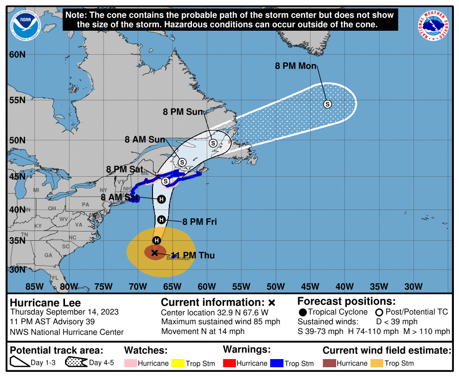
LOCATION...32.9N 67.6W
ABOUT 170 MI...270 KM WNW OF BERMUDA
ABOUT 590 MI...945 KM SSE OF NANTUCKET MASSACHUSETTS
MAXIMUM SUSTAINED WINDS...85 MPH...140 KM/H
PRESENT MOVEMENT...N OR 10 DEGREES AT 14 MPH...22 KM/H
MINIMUM CENTRAL PRESSURE...957 MB...28.26 INCHES
WATCHES AND WARNINGS
--------------------
CHANGES WITH THIS ADVISORY:
The Canadian Hurricane Center has issued a Tropical Storm Warning
for New Brunswick from the U.S./Canada border to Fort Lawrence,
including Grand Manan Island, and a Tropical Storm Warning for the
coast of Nova Scotia from Fort Lawrence to Point Tupper.
SUMMARY OF WATCHES AND WARNINGS IN EFFECT:
A Hurricane Watch is in effect for...
* Stonington, Maine to the U.S./Canada border
* New Brunswick from the U.S./Canada border to Point Lepreau,
including Grand Manan Island
* Nova Scotia from Digby to Medway Harbour
A Tropical Storm Warning is in effect for...
* Bermuda
* Westport Massachusetts northward to the U.S./Canada border
* Martha's Vineyard
* Nantucket
* New Brunswick from the U.S./Canada border to Fort Lawrence,
including Grand Manan Island
* Nova Scotia from Fort Lawrence to Point Tupper
A Hurricane Watch means that hurricane conditions are possible
within the watch area. A watch is typically issued 48 hours
before the anticipated first occurrence of tropical-storm-force
winds, conditions that make outside preparations difficult or
dangerous.
A Tropical Storm Warning means that tropical storm conditions are
expected somewhere within the warning area within 36 hours.
Interests elsewhere in the northeastern United States and Atlantic
Canada should monitor the progress of Lee.
For storm information specific to your area in the United
States, including possible inland watches and warnings, please
monitor products issued by your local National Weather Service
forecast office. For storm information specific to your area
outside of the United States, please monitor products issued by
your national meteorological service.
DISCUSSION AND OUTLOOK
----------------------
At 1100 PM AST (0300 UTC), the center of Hurricane Lee was located
near latitude 32.9 North, longitude 67.6 West. Lee is moving toward
the north near 14 mph (22 km/h), and this general motion with an
increase in forward speed is expected through Saturday. A turn
toward the north-northeast and then northeast is forecast Saturday
night and Sunday. On the forecast track, the center of Lee will
continue to pass west-northwest of Bermuda through tonight,
approach the coast of New England and Atlantic Canada Friday and
Saturday, and move across Atlantic Canada Saturday night and Sunday.
Maximum sustained winds remain near 85 mph (140 km/h) with higher
gusts. Little change in strength is expected through Friday
afternoon. Some gradual weakening is forecast Friday night and
Saturday, but Lee is expected to remain large and dangerous for the
next couple of days.
Lee is a very large hurricane. Hurricane-force winds extend
outward up to 105 miles (165 km) from the center and
tropical-storm-force winds extend outward up to 345 miles (555 km).
A sustained wind of 40 mph (65 km/h) with a gust to 53 mph (85
km/h) was recently reported at the L.F. Wade International Airport
on Bermuda.
The minimum central pressure estimated from Air Force Hurricane
Hunter observations is 957 mb (28.26 inches).
HAZARDS AFFECTING LAND
----------------------
Key messages for Lee can be found in the Tropical Cyclone Discussion
under AWIPS header MIATCDAT3 and WMO header WTNT43 KNHC and on the
web at hurricanes.gov/text/MIATCDAT3.shtml
WIND: Tropical storm conditions will continue on Bermuda through
Friday morning. Hurricane conditions are possible in the Hurricane
Watch areas in Down East Maine and in Atlantic Canada on Saturday.
Tropical storm conditions are expected to begin in southern New
England on Friday afternoon and spread northward within the
Tropical Storm Warning area through Saturday. Tropical storm
conditions are expected in the Tropical Storm Warning area in
Atlantic Canada by late Friday into Saturday.
STORM SURGE: The combination of storm surge and tide will cause
normally dry areas near the coast to be flooded by rising waters
moving inland from the shoreline. The water could reach the
following heights above ground somewhere in the indicated areas if
the peak surge occurs at the time of high tide...
Flushing, NY to U.S./Canada border...1-3 ft
Long Island Sound...1-3 ft
Cape Cod...1-3 ft
Martha's Vineyard and Nantucket...1-3 ft
Boston Harbor...1-3 ft
Rockaway Inlet, NY to Montauk Point, NY...1-2 ft
The deepest water will occur along the immediate coast where the
surge will be accompanied by large and destructive waves.
Surge-related flooding depends on the relative timing of the surge
and the tidal cycle, and can vary greatly over short distances. For
information specific to your area, please see products issued by
your local National Weather Service forecast office.
A dangerous storm surge will produce coastal flooding within the
wind warning areas in Atlantic Canada in areas of onshore winds.
Near the coast, the surge will be accompanied by large and
destructive waves.
SURF: Swells generated by Lee are affecting portions of the Lesser
Antilles, the British and U.S. Virgin Islands, Puerto Rico,
Hispaniola, the Turks and Caicos Islands, the Bahamas, Bermuda, the
east coast of the United States, and Atlantic Canada. These swells
are likely to cause life-threatening surf and rip current
conditions. Please consult products from your local weather office.
RAINFALL: Outer rain bands from Lee may produce rainfall amounts of
1 to 2 inches, or 25 to 50 millimeters, across Bermuda overnight
and early Friday.
From Friday night through Saturday night, Lee is expected to produce
rainfall amounts of 1 to 4 inches, or 25 to 100 millimeters, across
portions of eastern New England into portions of New Brunswick and
Nova Scotia. This may produce localized urban and small stream
flooding.
NEXT ADVISORY
-------------
Next intermediate advisory at 200 AM AST.
Next complete advisory at 500 AM AST.
$$
Forecaster Pasch
691
WTNT43 KNHC 150250
TCDAT3
Hurricane Lee Discussion Number 39
NWS National Hurricane Center Miami FL AL132023
1100 PM AST Thu Sep 14 2023
Observations from an Air Force Reserve Unit Hurricane Hunter
aircraft indicate that Lee's eyewall is not well defined, and this
is also suggested by geostationary satellite and microwave imagery.
Although the peak 700 mb flight-level winds reported by the plane
were near 93 kt, the highest SFMR-observed surface winds were 72 kt.
Thus the winds aloft in the hurricane are not being transported
very effectively to the surface. This is not surprising, since the
central deep convection is no longer very strong. The current
intensity is kept at 75 kt based on the aircraft data, which is
well above the Dvorak satellite estimates.
Lee wobbled a bit to the northeast early this evening, but the
longer-term motion appears to be just east of north, or around
010/12 kt. The system should move generally northward at a faster
forward speed, on the west side of a mid-level ridge, during the
next day or so. A slight bend to the left is likely late Friday as
the cyclone interacts with a mid-level trough. By late Saturday,
Lee should begin to turn toward the north-northeast with the center
passing near or over western Nova Scotia. Then, Lee is forecast to
turn northeastward over Atlantic Canada. The track guidance remains
in good agreement through 72 hours, and the official forecast is
basically an update of the previous one.
South-southwesterly shear is predicted to increase significantly
over Lee during the next couple of days. This, along with cooler
SSTs, particularly after the system moves north of 40N latitude,
should result in weakening. However, baroclinic processes could
help the cyclone maintain its intensity, or at least slow the
weakening rate. The official intensity forecast is above the model
guidance for this reason. In 48 hours, simulated satellite imagery
shows an asymmetric cloud structure characteristic of an
extratropical cyclone. Regardless of when extratropical transition
actually occurs, however, Lee should remain a very large and
dangerous cyclone through landfall.
KEY MESSAGES:
1. Tropical storm conditions, heavy rainfall, and high surf will
continue to impact Bermuda through Friday morning, and a Tropical
Storm Warning is in effect for the island.
2. Hurricane conditions and coastal flooding are possible in
portions of eastern Maine, southern New Brunswick, and western Nova
Scotia on Saturday, and a Hurricane Watch is in effect for that
area. Tropical storm conditions and coastal flooding are expected
to begin in southern New England on Friday afternoon, and spread
northward along the coast of New England and over portions of
Atlantic Canada through Saturday where Tropical Storm warnings are
in effect.
3. Heavy rainfall from Lee may produce localized urban and small
stream flooding across eastern New England and into portions of New
Brunswick and Nova Scotia from Friday night into Saturday night.
FORECAST POSITIONS AND MAX WINDS
INIT 15/0300Z 32.9N 67.6W 75 KT 85 MPH
12H 15/1200Z 35.0N 67.3W 75 KT 85 MPH
24H 16/0000Z 38.4N 66.6W 75 KT 85 MPH
36H 16/1200Z 41.6N 66.6W 65 KT 75 MPH
48H 17/0000Z 44.3N 66.0W 60 KT 70 MPH...POST-TROP/INLAND
60H 17/1200Z 47.0N 63.6W 45 KT 50 MPH...POST-TROP/EXTRATROP
72H 18/0000Z 49.6N 59.1W 40 KT 45 MPH...POST-TROP/EXTRATROP
96H 19/0000Z 54.5N 42.5W 35 KT 40 MPH...POST-TROP/EXTRATROP
120H 20/0000Z...DISSIPATED
$$
Forecaster Pasch


No comments:
Post a Comment