Thursday, August 31, 2023

Isolated Rain Possible Tomorrow, Overall Dry and Mild Pattern

(Forecast)

Friday (High 82, Low 65): Mostly sunny. An isolated shower or thunderstorm is possible. 

Saturday (High 83, Low 64): Mostly sunny. Mild and dry air. 

Sunday (High 85, Low 63): Mostly sunny. Mild and dry.

(Extended Outlook)

Labor Day (High 86, Low 63): Mostly sunny.

Tuesday (High 88, Low 65): Mostly sunny.

Wednesday (High 90, Low 67): Mostly sunny.

Thursday (High 92, Low 69): Mostly sunny.

(Tea Leaves Territory)

Friday (High 93, Low 70): Mostly sunny.

Saturday (High 92, Low 69): Mostly sunny.

Sunday (High 93, Low 69): Mostly sunny. 

(Beach Forecast)

Friday (High 90, Low 75): Thunderstorms.

Saturday (High 88, Low 76): Thunderstorms. 

Sunday (High 89, Low 76): Thunderstorms still likely.

Labor Day (High 90, Low 75): Partly cloudy with a 40% chance of showers/thunderstorms. 

Tuesday through Thursday (Highs in lower 90's, Lows in mid-70's): Mostly sunny with a 20% chance of a passing shower or thunderstorm. 

(Pronóstico)

Viernes (Máxima 82, Mínima 65): Mayormente soleado. Es posible que se produzcan una lluvia o tormenta aislada.

Sábado (Máxima 83, Mínima 64): Mayormente soleado. Aire templado y seco.

Domingo (Máxima 85, Mínima 63): Mayormente soleado. Suave y seco.

(Perspectiva Extendida)

Día Laboral (Máxima 86, Mínima 63): Mayormente soleado.

Martes (Máxima 88, Mínima 65): Mayormente soleado.

Miércoles (Máxima 90, Mínima 67): Mayormente soleado.

Jueves (Máxima 92, Mínima 69): Mayormente soleado.

(Territorio de las Hojas de Té)

Viernes (Máxima 93, Mínima 70): Mayormente soleado.

Sábado (Máxima 92, Mínima 69): Mayormente soleado.

Domingo (Máxima 93, Mínima 69): Mayormente soleado.

(Pronóstico de la Playa)

Viernes (Máxima 90, Mínima 75): Tormentas eléctricas.

Sábado (Máxima 88, Mínima 76): Tormentas eléctricas.

Domingo (Máxima 89, Mínima 76): Aún es probable que haya tormentas eléctricas.

Día Laboral (Máxima 90, Mínima 75): Parcialmente nublado con un 40% de probabilidad de lluvias/tormentas eléctricas.

De Martes a Jueves (Máximas en los 90 grados inferiores, Mínimas a mediados de los 70 grados): Mayormente soleado con un 20 % de probabilidad de lluvia pasajera o tormenta eléctrica.

Wednesday, August 30, 2023

Staying Mostly Dry With Low Humidity and Mild Temperatures

Thursday (High 83, Low 60): Sunny. Mild and dry.

Friday (High 81, Low 64): Mostly sunny. An isolated shower or thunderstorm is possible. 

Saturday (High 82, Low 65): Mostly sunny. An isolated shower or thunderstorm is possible, mainly in the morning. 

Sunday (High 85, Low 63): Sunny.

Labor Day (High 86, Low 62): Sunny.

Tuesday (High 88, Low 63): Sunny.

Wednesday (High 90, Low 66): Sunny.

Thumbnail Update

Our weather is calm right now. And I'm tired, also concerned about some people who may have sheltered in place for the hurricane. So just going to hit the high points this evening. 

(Edit 9:12 PM - I had an afterthought and a second wind and actually did post a proper forecast.)


The remnants of Hurricane Idalia have moved into the Carolinas. It is not down to tropical storm strength, and it will soon move into the Atlantic Ocean, and we'll see what it does from there. The Island of Bermuda needs to watch its progress, though the computer models have been all over the place with what its future track could be. It has caused some flash flooding issues that are ongoing in South Carolina. 

Tonight we should get down to about 60 degrees locally, Lower 80's for the High tomorrow under sunny skies, the breeze from the hurricane will be gone. So sunny and about 83 tomorrow, Low of 60. Then the Low might edge more toward the mid-60's when we briefly get some return flow from the Gulf of Mexico on Friday, High down close to 80, more clouds around and a chance for rain, but any showers or thunderstorms should stay pretty isolated across the region. Then mostly sunny skies return Saturday and Sunday, High in lower to mid-80's and Lows in the lower to mid-60's. Then sunny skies continue for Labor Day with a High in the upper 80's. Sunshine should stay around through next Wednesday, when High may get up to 90 again, air is dry enough that Lows may actually stay in lower 60's. 

Hurricane Idalia Makes Landfall at Keaton Beach


So it is inland now. 


Here is the best media report I found scrolling around. 

000

WTNT65 KNHC 301145

TCUAT5


Hurricane Idalia Tropical Cyclone Update

NWS National Hurricane Center Miami FL       AL102023

745 AM EDT Wed Aug 30 2023


...EXTREMELY DANGEROUS CATEGORY 3 HURRICANE IDALIA MAKES LANDFALL 

IN THE FLORIDA BIG BEND...

...745 AM POSITION UPDATE...


NOAA Doppler radar imagery indicate that the eye of Idalia made 

landfall along the coast of the Florida Big Bend near Keaton Beach 

around 745 AM EDT (1145 UTC).   Data from an Air Force Reserve 

Hurricane Hunter aircraft indicate that Idalia's maximum sustained 

winds were near 125 mph (205 km/h).  The latest minimum pressure 

central pressure estimated from reconnaissance data is 949 mb (28.02 

inches).


Within the past hour, a C-MAN station at Keaton Beach, Florida, 

measured sustained winds of 61 mph (98 km/h), with a gust to 77 mph 

(124 km/h).  A Florida Coastal Monitoring Program tower located 

southwest of Hampton Springs, Florida, recently reported a wind gust 

of 68 mph (109 km/h). 


Water levels along the coast of the Florida Big Bend are rising 

rapidly.  A NOAA National Ocean Service tide gauge at Cedar Key, 

Florida, recently reported a water level of 5.9 feet above mean 

higher high water, which is an approximation of inundation in that 

area. 


SUMMARY OF 745 AM EDT...1145 UTC...INFORMATION

----------------------------------------------

LOCATION...29.8N 83.6W

ABOUT 20 MI...30 KM S OF PERRY FLORIDA

ABOUT 55 MI...90 KM NW OF CEDAR KEY FLORIDA

MAXIMUM SUSTAINED WINDS...125 MPH...205 KM/H

PRESENT MOVEMENT...NNE OR 20 DEGREES AT 18 MPH...30 KM/H

MINIMUM CENTRAL PRESSURE...949 MB...28.02 INCHES


$$

Forecaster Brown/Stevenson

Hurricane Idalia Starting To Move Inland


 Rough stuff. 

119 

WTNT65 KNHC 301059

TCUAT5


Hurricane Idalia Tropical Cyclone Update

NWS National Hurricane Center Miami FL       AL102023

700 AM EDT Wed Aug 30 2023


...CATASTROPHIC STORM SURGE AND DESTRUCTIVE WINDS OCCURRING IN THE 

FLORIDA BIG BEND REGION...

...7 AM POSITION UPDATE...


Radar and Air Force Reserve Hurricane Hunter aircraft data 

indicate that an eyewall replacement cycle has begun.  Idalia's 

maximum sustained winds are now estimated near 125 mph (205 km/h) 

with higher gusts.  This change in wind speed does not diminish the 

threat of catastrophic storm surge and damaging winds. 


The estimated minimum pressure indicated by Air Force Reserve 

Hurricane Hunter aircraft data is 947 mb (27.96 inches).


Within the past hour, a C-MAN station on Cedar Key measured 

sustained winds of 47 mph (76 km/h), with a gust to 55 mph (88 

km/h), and a Weatherflow station at Apalachee Bay measured a 

sustained wind of 43 mph (69 km/h), with a gust to 55 mph (88 

km/h).  A Florida Coastal Monitoring Program tower near Lake City, 

Florida, recently reported a wind gust to 51 mph (82 km/h). 


A NOAA National Ocean Service tide gauge at Cedar Key, Florida, 

recently reported a water level of 5.2 feet above mean higher high 

water, which is an approximation of inundation in that area. 


SUMMARY OF 700 AM EDT...1100 UTC...INFORMATION

----------------------------------------------

LOCATION...29.6N 83.8W

ABOUT 55 MI...90 KM NW OF CEDAR KEY FLORIDA

ABOUT 65 MI...105 KM SSE OF TALLAHASSEE FLORIDA

MAXIMUM SUSTAINED WINDS...125 MPH...205 KM/H

PRESENT MOVEMENT...NNE OR 20 DEGREES AT 18 MPH...30 KM/H

MINIMUM CENTRAL PRESSURE...947 MB...27.96 INCHES


$$

Forecaster Brown/Stevenson

Hurricane Idalia Nearing Florida Bend With 130 Sustained Winds


Can't help sort of feeling for people in the path of this who were not able to evacuate. This storm has a smaller eyewall than usual but is still as fierce as it was expected to be. Next few hours, it will move inland. And then we'll see how things go. 

000

WTNT35 KNHC 300858

TCPAT5


BULLETIN

Hurricane Idalia Advisory Number  15

NWS National Hurricane Center Miami FL       AL102023

500 AM EDT Wed Aug 30 2023


...IDALIA RAPIDLY INTENSIFIES INTO A CATEGORY 4 HURRICANE...

...CATASTROPHIC STORM SURGE AND DESTRUCTIVE WINDS ARE NEARING THE

FLORIDA BIG BEND REGION...


SUMMARY OF 500 AM EDT...0900 UTC...INFORMATION

----------------------------------------------

LOCATION...29.1N 84.1W

ABOUT 60 MI...95 KM W OF CEDAR KEY FLORIDA

ABOUT 90 MI...145 KM S OF TALLAHASSEE FLORIDA

MAXIMUM SUSTAINED WINDS...130 MPH...215 KM/H

PRESENT MOVEMENT...NNE OR 25 DEGREES AT 18 MPH...30 KM/H

MINIMUM CENTRAL PRESSURE...940 MB...27.76 INCHES


WATCHES AND WARNINGS

--------------------

CHANGES WITH THIS ADVISORY:


A Hurricane Warning has been issued for the east coast of the

United States from Altamaha Sound Georgia to Edisto Beach South

Carolina.


A Storm Surge Warning has been issued from St. Catherine's Sound to

South Santee River.


A Hurricane Watch has been issued from Edisto Beach South Carolina

to South Santee River South Carolina.


A Tropical Storm Warning has been issued from North of Surf City

North Carolina to the North Carolina/Virginia border, and Pamlico

and Albemarle Sounds.


The Tropical Storm Warning for the west coast of Florida from

Bonita Beach southward is discontinued.


SUMMARY OF WATCHES AND WARNINGS IN EFFECT:


A Storm Surge Warning is in effect for...

* Englewood northward to Indian Pass, including Tampa Bay

* St. Catherine's Sound to South Santee River


A Hurricane Warning is in effect for...

* Middle of Longboat Key northward to Indian Pass, including Tampa

Bay


A Tropical Storm Warning is in effect for...

* Chokoloskee northward to the Middle of Longboat Key

* West of Indian Pass to Mexico Beach

* Sebastian Inlet Florida to Surf City North Carolina


A Storm Surge Watch is in effect for...

* Bonita Beach northward to Englewood, including Charlotte Harbour

* Mouth of the St. Mary's River to St. Catherine's Sound Georgia

* Beaufort Inlet to Drum Inlet North Carolina

* Neuse and Pamlico Rivers North Carolina


A Hurricane Watch is in effect for...

* Mouth of the St. Mary's River to Altamaha Sound

* Edisto Beach to South Santee River


A Hurricane Warning means that hurricane conditions are expected

somewhere within the warning area. Preparations to protect life

and property should be rushed to completion.


A Storm Surge Warning means there is a danger of life-threatening

inundation, from rising water moving inland from the coastline,

during the next 36 hours in the indicated locations. For a

depiction of areas at risk, please see the National Weather

Service Storm Surge Watch/Warning Graphic, available at

hurricanes.gov.  This is a life-threatening situation.  Persons

located within these areas should take all necessary actions to

protect life and property from rising water and the potential for

other dangerous conditions.  Promptly follow evacuation and other

instructions from local officials.


A Tropical Storm Warning means that tropical storm conditions are

expected somewhere within the warning area.


A Storm Surge Watch means there is a possibility of life-

threatening inundation, from rising water moving inland from the

coastline, in the indicated locations during the next 48 hours.

For a depiction of areas at risk, please see the National Weather

Service Storm Surge Watch/Warning Graphic, available at

hurricanes.gov.


A Hurricane Watch means that hurricane conditions are possible

within the watch area.


Additional warnings could be required later today.


For storm information specific to your area, including possible

inland watches and warnings, please monitor products issued by your

local National Weather Service forecast office.


DISCUSSION AND OUTLOOK

----------------------

At 500 AM EDT (0900 UTC), the eye of Hurricane Idalia was located

by Tallahassee radar near latitude 29.1 North, longitude 84.1 West.

Idalia is moving toward the north-northeast near 18 mph (30 km/h).

A north-northeastward motion is expected through the morning, with

Idalia's center forecast to reach the Big Bend coast of Florida this

morning. After landfall, Idalia is forecast to turn toward the

northeast and east-northeast, moving near or along the coasts of

Georgia, South Carolina, and North Carolina late today and Thursday.


Hurricane Hunter aircraft data indicate that maximum sustained winds

have increased to near 130 mph (215 km/h) with higher gusts.

Idalia is a category 4 hurricane on the Saffir-Simpson Hurricane

Wind Scale.  Idalia could continue to strengthen before it

reaches the Big Bend coast of Florida in a few hours.  While

Idalia should weaken after landfall, it is likely to still be a

hurricane while moving across southern Georgia, and near the coast

of Georgia or southern South Carolina late today.  Idalia should

emerge off the southeastern United States coast early on Thursday

and move eastward through late week.


Hurricane-force winds extend outward up to 25 miles (35 km) from the

center and tropical-storm-force winds extend outward up to 175 miles

(280 km).


The estimated minimum central pressure is 940 mb (27.76 inches) 

based on aircraft data.


HAZARDS AFFECTING LAND

----------------------

Key messages for Idalia can be found in the Tropical Cyclone

Discussion under AWIPS header MIATCDAT5 and WMO header WTNT45 KNHC,

and on the web at hurricanes.gov/text/MIATCDAT5.shtml


STORM SURGE: The combination of storm surge and tide will cause

normally dry areas near the coast to be flooded by rising waters

moving inland from the shoreline.  The water could reach the

following heights above ground somewhere in the indicated areas if

the peak surge occurs at the time of high tide...


Wakulla/Jefferson County, FL to Yankeetown, FL...12-16 ft

Ochlockonee River, FL to Wakulla/Jefferson County, FL...8-12 ft

Yankeetown, FL to Chassahowitzka, FL...7-11 ft

Chassahowitzka, FL to Anclote River, FL...6-9 ft

Carrabelle, FL to Ochlockonee River, FL...5-8 ft

Anclote River, FL to Middle of Longboat Key, FL...4-6 ft

Tampa Bay...4-6 ft

Indian Pass, FL to Carrabelle, FL...3-5 ft

Middle of Longboat Key, FL to Englewood, FL...3-5 ft

Saint Catherines Sound, GA to South Santee River, SC...3-5 ft

Englewood, FL to Bonita Beach, FL...2-4 ft

Beaufort Inlet, NC to Ocracoke Inlet, NC...2-4 ft

Mouth of the St. Mary's River to Saint Catherines Sound, GA...2-4 ft

Charlotte Harbor...2-4 ft

Neuse and Bay Rivers...2-4 ft

Pamlico and Pungo Rivers...2-4 ft

Flagler/Volusia County Line, FL to Mouth of the St. Mary's 

River...1-3 ft

Mexico Beach, FL to Indian Pass, FL...1-3 ft

Bonita Beach, FL to East Cape Sable, FL...1-3 ft

South Santee River, SC to Beaufort Inlet, NC...1-3 ft

Ocracoke Inlet, NC to Duck, NC...1-3 ft


The deepest water will occur along the immediate coast near and to

the right of the center, where the surge will be accompanied by

large and destructive waves. Surge-related flooding depends on the

relative timing of the surge and the tidal cycle, and can vary

greatly over short distances.  For information specific to your

area, please see products issued by your local National Weather

Service forecast office.


WIND:  Hurricane conditions are expected within the hurricane

warning area in Florida soon, with tropical storm conditions

spreading northward and westward through this morning.


Tropical storm conditions will continue within the tropical storm

warning area along the Florida Gulf and west coasts.


Hurricane conditions are expected in the Hurricane Warning area

along the coasts of Georgia and South Carolina later today and

tonight.


Hurricane conditions are possible in the Hurricane Watch area along

the coasts of Georgia and South Carolina later today and tonight.


Tropical storm conditions are expected to begin later today in the

warning area along the east coast of Florida, Georgia, and South

Carolina, and spread into North Carolina tonight and Thursday.


RAINFALL:  Idalia is expected to produce a swath of 4 to 8 inches of

rainfall with isolated maxima up to 12 inches from the Florida Big

Bend through central Georgia and South Carolina, and through eastern

North Carolina into Thursday. These rainfall amounts will lead to

areas of flash, urban, and moderate river flooding, with

considerable impacts.


SURF:  Swells generated by Idalia are affecting the southwestern

coast of Florida and will spread northward and westward to the

north-central Gulf coast through today.  These swells are

likely to cause life-threatening surf and rip current conditions.

Please consult products from your local weather office.


TORNADOES: A few tornadoes are possible this morning across

west-central and northern Florida into southeast Georgia, with the

tornado risk shifting toward the coastal Carolinas this afternoon

and tonight.


NEXT ADVISORY

-------------

Next intermediate advisory at 800 AM EDT.

Next complete advisory at 1100 AM EDT.


$$

Forecaster Blake


000

WTNT25 KNHC 300856

TCMAT5


HURRICANE IDALIA FORECAST/ADVISORY NUMBER  15

NWS NATIONAL HURRICANE CENTER MIAMI FL       AL102023

0900 UTC WED AUG 30 2023


NOTICE... LAND-BASED TROPICAL CYCLONE WATCHES AND WARNINGS ARE NO

LONGER INCLUDED IN THE TROPICAL CYCLONE FORECAST/ADVISORY...(TCM).

CURRENT LAND-BASED COASTAL WATCHES AND WARNINGS CAN BE FOUND IN THE

MOST RECENTLY ISSUED TROPICAL CYCLONE PUBLIC ADVISORY...(TCP).


HURRICANE CENTER LOCATED NEAR 29.1N  84.1W AT 30/0900Z

POSITION ACCURATE WITHIN  15 NM


PRESENT MOVEMENT TOWARD THE NORTH-NORTHEAST OR  25 DEGREES AT  16 KT


ESTIMATED MINIMUM CENTRAL PRESSURE  940 MB

EYE DIAMETER  10 NM

MAX SUSTAINED WINDS 115 KT WITH GUSTS TO 140 KT.

64 KT....... 20NE  20SE  15SW  10NW.

50 KT....... 60NE  50SE  30SW  40NW.

34 KT.......120NE 150SE  50SW  60NW.

12 FT SEAS.. 90NE 150SE 135SW 135NW.

WINDS AND SEAS VARY GREATLY IN EACH QUADRANT.  RADII IN NAUTICAL

MILES ARE THE LARGEST RADII EXPECTED ANYWHERE IN THAT QUADRANT.


REPEAT...CENTER LOCATED NEAR 29.1N  84.1W AT 30/0900Z

AT 30/0600Z CENTER WAS LOCATED NEAR 28.3N  84.5W


FORECAST VALID 30/1800Z 31.0N  82.7W...INLAND

MAX WIND  85 KT...GUSTS 105 KT.

64 KT... 15NE  15SE  10SW  10NW.

50 KT... 40NE  40SE  20SW  20NW.

34 KT...120NE 160SE  60SW  60NW.


FORECAST VALID 31/0600Z 33.1N  79.6W...INLAND

MAX WIND  60 KT...GUSTS  75 KT.

50 KT... 20NE  30SE  30SW  20NW.

34 KT...120NE 170SE  50SW  30NW.


FORECAST VALID 31/1800Z 33.8N  76.1W...OVER WATER

MAX WIND  50 KT...GUSTS  60 KT.

50 KT... 30NE  30SE  30SW  60NW.

34 KT...160NE 140SE 130SW  90NW.


FORECAST VALID 01/0600Z 33.3N  72.7W

MAX WIND  50 KT...GUSTS  60 KT.

50 KT... 20NE   0SE  20SW  40NW.

34 KT...170NE  80SE 150SW 150NW.


FORECAST VALID 01/1800Z 32.4N  70.7W

MAX WIND  45 KT...GUSTS  55 KT.

34 KT...120NE  70SE  80SW  90NW.


FORECAST VALID 02/0600Z 31.5N  69.5W

MAX WIND  45 KT...GUSTS  55 KT.

34 KT...130NE  60SE  80SW 120NW.


EXTENDED OUTLOOK. NOTE...ERRORS FOR TRACK HAVE AVERAGED NEAR 125 NM

ON DAY 4 AND 175 NM ON DAY 5...AND FOR INTENSITY NEAR 15 KT EACH DAY


OUTLOOK VALID 03/0600Z 30.7N  68.0W

MAX WIND  45 KT...GUSTS  55 KT.


OUTLOOK VALID 04/0600Z 30.5N  66.0W

MAX WIND  45 KT...GUSTS  55 KT.


REQUEST FOR 3 HOURLY SHIP REPORTS WITHIN 300 MILES OF 29.1N  84.1W


INTERMEDIATE PUBLIC ADVISORY...WTNT35 KNHC/MIATCPAT5...AT 30/1200Z


NEXT ADVISORY AT 30/1500Z


$$

FORECASTER BLAKE


000

FONT15 KNHC 300856

PWSAT5


HURRICANE IDALIA WIND SPEED PROBABILITIES NUMBER  15                

NWS NATIONAL HURRICANE CENTER MIAMI FL       AL102023               

0900 UTC WED AUG 30 2023                                            


AT 0900Z THE CENTER OF HURRICANE IDALIA WAS LOCATED NEAR LATITUDE   

29.1 NORTH...LONGITUDE 84.1 WEST WITH MAXIMUM SUSTAINED WINDS NEAR  

115 KTS...130 MPH...215 KM/H.                                       


Z INDICATES COORDINATED UNIVERSAL TIME (GREENWICH)                  

   ATLANTIC STANDARD TIME (AST)...SUBTRACT 4 HOURS FROM Z TIME      

   EASTERN  DAYLIGHT TIME (EDT)...SUBTRACT 4 HOURS FROM Z TIME      

   CENTRAL  DAYLIGHT TIME (CDT)...SUBTRACT 5 HOURS FROM Z TIME      


WIND SPEED PROBABILITY TABLE FOR SPECIFIC LOCATIONS                 


CHANCES OF SUSTAINED (1-MINUTE AVERAGE) WIND SPEEDS OF AT LEAST     

   ...34 KT (39 MPH... 63 KM/H)...                                  

   ...50 KT (58 MPH... 93 KM/H)...                                  

   ...64 KT (74 MPH...119 KM/H)...                                  

FOR LOCATIONS AND TIME PERIODS DURING THE NEXT 5 DAYS               


PROBABILITIES FOR LOCATIONS ARE GIVEN AS OP(CP) WHERE               

    OP  IS THE PROBABILITY OF THE EVENT BEGINNING DURING            

        AN INDIVIDUAL TIME PERIOD (ONSET PROBABILITY)               

   (CP) IS THE PROBABILITY OF THE EVENT OCCURRING BETWEEN           

        06Z WED AND THE FORECAST HOUR (CUMULATIVE PROBABILITY)      


PROBABILITIES ARE GIVEN IN PERCENT                                  

X INDICATES PROBABILITIES LESS THAN 1 PERCENT                       

PROBABILITIES FOR 34 KT AND 50 KT ARE SHOWN AT A GIVEN LOCATION WHEN

THE 5-DAY CUMULATIVE PROBABILITY IS AT LEAST 3 PERCENT.             

PROBABILITIES FOR 34...50...64 KT SHOWN WHEN THE 5-DAY              

64-KT CUMULATIVE PROBABILITY IS AT LEAST 1 PERCENT.                 


  - - - - WIND SPEED PROBABILITIES FOR SELECTED LOCATIONS - - - -   


               FROM    FROM    FROM    FROM    FROM    FROM    FROM 

  TIME       06Z WED 18Z WED 06Z THU 18Z THU 06Z FRI 06Z SAT 06Z SUN

PERIODS         TO      TO      TO      TO      TO      TO      TO  

             18Z WED 06Z THU 18Z THU 06Z FRI 06Z SAT 06Z SUN 06Z MON


FORECAST HOUR    (12)   (24)    (36)    (48)    (72)    (96)   (120)

- - - - - - - - - - - - - - - - - - - - - - - - - - - - - - - - - - 

LOCATION       KT                                                   


OCEANA NAS VA  34  X   1( 1)   1( 2)   1( 3)   X( 3)   1( 4)   X( 4)


CAPE HATTERAS  34  X   2( 2)  15(17)   4(21)   1(22)   X(22)   X(22)


FAYETTEVILLE   34  X   4( 4)   2( 6)   X( 6)   X( 6)   X( 6)   X( 6)


CHERRY PT NC   34  X   2( 2)  12(14)   1(15)   X(15)   X(15)   X(15)


NEW RIVER NC   34  X   4( 4)  37(41)   2(43)   X(43)   X(43)   X(43)

NEW RIVER NC   50  X   X( X)   6( 6)   1( 7)   X( 7)   X( 7)   X( 7)


MOREHEAD CITY  34  X   5( 5)  36(41)   1(42)   X(42)   X(42)   X(42)

MOREHEAD CITY  50  X   X( X)   7( 7)   X( 7)   X( 7)   X( 7)   X( 7)


SURF CITY NC   34  X  16(16)  40(56)   X(56)   X(56)   X(56)   X(56)

SURF CITY NC   50  X   1( 1)  10(11)   X(11)   X(11)   X(11)   X(11)


WILMINGTON NC  34  X  13(13)  29(42)   X(42)   X(42)   X(42)   X(42)

WILMINGTON NC  50  X   1( 1)   2( 3)   X( 3)   X( 3)   X( 3)   X( 3)


BALD HEAD ISL  34  X  46(46)  33(79)   X(79)   X(79)   X(79)   X(79)

BALD HEAD ISL  50  X   5( 5)  26(31)   X(31)   X(31)   X(31)   X(31)

BALD HEAD ISL  64  X   1( 1)   3( 4)   X( 4)   X( 4)   X( 4)   X( 4)


FLORENCE SC    34  1  27(28)   2(30)   X(30)   X(30)   X(30)   X(30)


COLUMBIA SC    34  1   9(10)   X(10)   X(10)   X(10)   X(10)   X(10)


LITTLE RIVER   34  1  65(66)  14(80)   X(80)   X(80)   X(80)   X(80)

LITTLE RIVER   50  X  13(13)  18(31)   X(31)   X(31)   X(31)   X(31)

LITTLE RIVER   64  X   1( 1)   2( 3)   X( 3)   X( 3)   X( 3)   X( 3)


MYRTLE BEACH   34  1  75(76)  10(86)   X(86)   X(86)   X(86)   X(86)

MYRTLE BEACH   50  X  24(24)  16(40)   X(40)   X(40)   X(40)   X(40)

MYRTLE BEACH   64  X   2( 2)   3( 5)   X( 5)   X( 5)   X( 5)   X( 5)


GEORGETOWN SC  34  1  80(81)   4(85)   X(85)   X(85)   X(85)   X(85)

GEORGETOWN SC  50  X  18(18)   2(20)   X(20)   X(20)   X(20)   X(20)


CHARLESTON SC  34  2  94(96)   X(96)   X(96)   X(96)   X(96)   X(96)

CHARLESTON SC  50  X  69(69)   1(70)   X(70)   X(70)   X(70)   X(70)

CHARLESTON SC  64  X  15(15)   X(15)   X(15)   X(15)   X(15)   X(15)


BEAUFORT MCAS  34 12  86(98)   X(98)   X(98)   X(98)   X(98)   X(98)

BEAUFORT MCAS  50  1  80(81)   X(81)   X(81)   X(81)   X(81)   X(81)

BEAUFORT MCAS  64  X  22(22)   X(22)   X(22)   X(22)   X(22)   X(22)


AUGUSTA GA     34  2   7( 9)   X( 9)   X( 9)   X( 9)   X( 9)   X( 9)


SAVANNAH GA    34 36  63(99)   X(99)   X(99)   X(99)   X(99)   X(99)

SAVANNAH GA    50  1  68(69)   X(69)   X(69)   X(69)   X(69)   X(69)

SAVANNAH GA    64  X   4( 4)   X( 4)   X( 4)   X( 4)   X( 4)   X( 4)


KINGS BAY GA   34 98   2(99)   X(99)   X(99)   X(99)   X(99)   X(99)

KINGS BAY GA   50 20  26(46)   X(46)   X(46)   X(46)   X(46)   X(46)

KINGS BAY GA   64  2   6( 8)   X( 8)   X( 8)   X( 8)   X( 8)   X( 8)


WAYCROSS GA    34 99   1(99)   X(99)   X(99)   X(99)   X(99)   X(99)

WAYCROSS GA    50 80  14(94)   X(94)   X(94)   X(94)   X(94)   X(94)

WAYCROSS GA    64 12   8(20)   X(20)   X(20)   X(20)   X(20)   X(20)


MAYPORT NS FL  34 96   3(99)   X(99)   X(99)   X(99)   X(99)   X(99)

MAYPORT NS FL  50 11   8(19)   X(19)   X(19)   X(19)   X(19)   X(19)

MAYPORT NS FL  64  1   1( 2)   X( 2)   X( 2)   X( 2)   X( 2)   X( 2)


JACKSONVILLE   34 98   1(99)   X(99)   X(99)   X(99)   X(99)   X(99)

JACKSONVILLE   50 14   4(18)   X(18)   X(18)   X(18)   X(18)   X(18)

JACKSONVILLE   64  1   X( 1)   X( 1)   X( 1)   X( 1)   X( 1)   X( 1)


GAINESVILLE FL 34 99   X(99)   X(99)   X(99)   X(99)   X(99)   X(99)

GAINESVILLE FL 50 12   X(12)   X(12)   X(12)   X(12)   X(12)   X(12)


DAYTONA BEACH  34 19   1(20)   X(20)   X(20)   X(20)   X(20)   X(20)


THE VILLAGES   34 95   X(95)   X(95)   X(95)   X(95)   X(95)   X(95)


ORLANDO FL     34  3   1( 4)   X( 4)   X( 4)   X( 4)   X( 4)   X( 4)


COCOA BEACH FL 34  2   2( 4)   X( 4)   X( 4)   X( 4)   X( 4)   X( 4)


PATRICK AFB    34  2   2( 4)   X( 4)   X( 4)   X( 4)   X( 4)   X( 4)


VENICE FL      34  3   X( 3)   X( 3)   X( 3)   X( 3)   X( 3)   X( 3)


TAMPA FL       34 99   X(99)   X(99)   X(99)   X(99)   X(99)   X(99)


CEDAR KEY FL   34 99   X(99)   X(99)   X(99)   X(99)   X(99)   X(99)

CEDAR KEY FL   50 65   X(65)   X(65)   X(65)   X(65)   X(65)   X(65)

CEDAR KEY FL   64  1   X( 1)   X( 1)   X( 1)   X( 1)   X( 1)   X( 1)


TALLAHASSEE FL 34 33   X(33)   X(33)   X(33)   X(33)   X(33)   X(33)

TALLAHASSEE FL 50  4   X( 4)   X( 4)   X( 4)   X( 4)   X( 4)   X( 4)


ST MARKS FL    34 89   X(89)   X(89)   X(89)   X(89)   X(89)   X(89)

ST MARKS FL    50 18   X(18)   X(18)   X(18)   X(18)   X(18)   X(18)

ST MARKS FL    64  1   X( 1)   X( 1)   X( 1)   X( 1)   X( 1)   X( 1)


APALACHICOLA   34  7   1( 8)   X( 8)   X( 8)   X( 8)   X( 8)   X( 8)


GFMX 290N 850W 34 99   X(99)   X(99)   X(99)   X(99)   X(99)   X(99)


BERMUDA        34  X   X( X)   X( X)   X( X)   2( 2)   5( 7)   7(14)


$$                                                                  

FORECASTER BLAKE                                                    


270 

WTNT45 KNHC 300857

TCDAT5


Hurricane Idalia Discussion Number  15

NWS National Hurricane Center Miami FL       AL102023

500 AM EDT Wed Aug 30 2023


Idalia continues to undergo rapid intensification.  Maximum

flight-level winds were 123 kt, with believable SFMR values of 115

kt.  Satellite images show a small eye surrounded by very cold

clouds tops, especially in the western quadrant.  The initial wind

speed is set to 115 kt, making Idalia an extremely dangerous

category 4 hurricane.


The hurricane still has a few hours left to intensify before it

makes landfall. The biggest change to the intensity forecast is to

increase the wind speeds over southeastern Georgia and South

Carolina as the rapid motion and track close to the coast is

expected to keep the system near hurricane strength for longer.

Thus a Hurricane Warning has been issued for a portion of those

coasts, and the Hurricane Watch is extended northeastward.  After

the hurricane moves offshore, the wind field on the northwestern

side near eastern North Carolina is expected to be enhanced by a

cold front, and the Tropical Storm Watch has been upgraded to a

Tropical Storm Warning in that area.  The long-range intensity

forecast is quite uncertain with Idalia taking on some hybrid

characteristics due to a baroclinc trough. No changes were made at

this time, and the forecast remains close to the consensus.


Idalia is moving faster toward the north-northeast or 025/16 kt.

After landfall, Idalia is expected to move near or along the coast

of Georgia and the Carolinas in 24-36 hours.  Uncertainty in the

track forecast beyond 48 hours remains quite large, and the latest

guidance is significantly faster.  The new forecast is adjusted

toward the consensus, but could be too slow at long range.


KEY MESSAGES:


1. Catastrophic impacts from storm surge inundation of 12 to 16 feet

above ground level and destructive waves are expected somewhere

between the Wakulla/Jefferson County line and Yankeetown, Florida.

Life-threatening storm surge inundation is likely elsewhere along

portions of the Florida Gulf Coast where a Storm Surge Warning is in

effect. Residents in these areas should follow any advice given by

local officials.


2. Destructive life-threatening winds will occur where the core of

Idalia moves onshore in the Big Bend region of Florida, with

hurricane conditions expected elsewhere in portions of the Hurricane

Warning area along the Florida Gulf Coast. Strong winds will also

spread inland across portions of northern Florida and southern

Georgia near the track of the center of Idalia where Hurricane

Warnings are in effect. Residents in these areas should be prepared

for long-duration power outages. Damaging hurricane-force winds are

likely in portions of eastern Georgia and southeastern South

Carolina where Hurricane Warnings are now in effect.


3. Areas of flash, urban, and moderate river flooding, with

considerable impacts, are expected from the Florida Big Ben through,

central Georgia and South Carolina, through eastern North Carolina

into Thursday.


FORECAST POSITIONS AND MAX WINDS


INIT  30/0900Z 29.1N  84.1W  115 KT 130 MPH

 12H  30/1800Z 31.0N  82.7W   85 KT 100 MPH...INLAND

 24H  31/0600Z 33.1N  79.6W   60 KT  70 MPH...INLAND

 36H  31/1800Z 33.8N  76.1W   50 KT  60 MPH...OVER WATER

 48H  01/0600Z 33.3N  72.7W   50 KT  60 MPH

 60H  01/1800Z 32.4N  70.7W   45 KT  50 MPH

 72H  02/0600Z 31.5N  69.5W   45 KT  50 MPH

 96H  03/0600Z 30.7N  68.0W   45 KT  50 MPH

120H  04/0600Z 30.5N  66.0W   45 KT  50 MPH


$$

Forecaster Blake

Hurricane Idalia Has Winds of 120 MPH, Nearing Landfall at Florida Bend


 427 

WTNT35 KNHC 300555

TCPAT5


BULLETIN

Hurricane Idalia Intermediate Advisory Number 14A

NWS National Hurricane Center Miami FL       AL102023

200 AM EDT Wed Aug 30 2023


...IDALIA RAPIDLY INTENSIFIES INTO A MAJOR HURRICANE...

...CATASTROPHIC STORM SURGE AND DESTRUCTIVE WINDS EXPECTED IN 

THE FLORIDA BIG BEND REGION THIS MORNING WHEN IDALIA MOVES INLAND...


SUMMARY OF 200 AM EDT...0600 UTC...INFORMATION

----------------------------------------------

LOCATION...28.3N 84.5W

ABOUT 100 MI...175 KM SW OF CEDAR KEY FLORIDA

ABOUT 175 MI...280 KM S OF TALLAHASSEE FLORIDA

MAXIMUM SUSTAINED WINDS...120 MPH...195 KM/H

PRESENT MOVEMENT...N OR 10 DEGREES AT 15 MPH...24 KM/H

MINIMUM CENTRAL PRESSURE...945 MB...27.91 INCHES


WATCHES AND WARNINGS

--------------------

CHANGES WITH THIS ADVISORY:


None.


SUMMARY OF WATCHES AND WARNINGS IN EFFECT:


A Storm Surge Warning is in effect for...

* Englewood northward to Indian Pass, including Tampa Bay


A Hurricane Warning is in effect for...

* Middle of Longboat Key northward to Indian Pass, including Tampa

Bay


A Tropical Storm Warning is in effect for...

* Chokoloskee northward to the Middle of Longboat Key

* West of Indian Pass to Mexico Beach

* Sebastian Inlet Florida to Surf City North Carolina


A Storm Surge Watch is in effect for...

* Bonita Beach northward to Englewood, including Charlotte Harbour

* Mouth of the St. Mary's River to South Santee River South

Carolina

* Beaufort Inlet to Drum Inlet North Carolina

* Neuse and Pamlico Rivers North Carolina


A Hurricane Watch is in effect for...

* Mouth of the St. Mary's River to Edisto Beach South Carolina


A Tropical Storm Watch is in effect for...

* North of Surf City North Carolina to the North Carolina/Virginia

border

* Pamlico and Albemarle Sounds


A Hurricane Warning means that hurricane conditions are expected

somewhere within the warning area. Preparations to protect life

and property should be rushed to completion.


A Storm Surge Warning means there is a danger of life-threatening

inundation, from rising water moving inland from the coastline,

during the next 36 hours in the indicated locations. For a

depiction of areas at risk, please see the National Weather

Service Storm Surge Watch/Warning Graphic, available at

hurricanes.gov.  This is a life-threatening situation.  Persons

located within these areas should take all necessary actions to

protect life and property from rising water and the potential for

other dangerous conditions.  Promptly follow evacuation and other

instructions from local officials.


A Tropical Storm Warning means that tropical storm conditions are

expected somewhere within the warning area.


A Storm Surge Watch means there is a possibility of life-

threatening inundation, from rising water moving inland from the

coastline, in the indicated locations during the next 48 hours.

For a depiction of areas at risk, please see the National Weather

Service Storm Surge Watch/Warning Graphic, available at

hurricanes.gov.


A Hurricane Watch means that hurricane conditions are possible

within the watch area.


A Tropical Storm Watch means that tropical storm conditions are

possible within the watch area, generally within 48 hours.


Additional warnings will likely be required later today.


For storm information specific to your area in the United

States, including possible inland watches and warnings, please

monitor products issued by your local National Weather Service

forecast office. For storm information specific to your area

outside of the United States, please monitor products issued by

your national meteorological service.


DISCUSSION AND OUTLOOK

----------------------

At 200 AM EDT (0600 UTC), the center of Hurricane Idalia was located

near latitude 28.3 North, longitude 84.5 West. Idalia is moving

toward the north near 15 mph (24 km/h). A northward to 

north-northeastward motion is expected through morning, with

Idalia's center forecast to reach the Big Bend coast of Florida this

morning. After landfall, Idalia is forecast to turn toward the 

northeast and east-northeast, moving near or along the coasts of 

Georgia, South Carolina, and North Carolina late today and Thursday.


Hurricane Hunter aircraft data indicate that maximum sustained winds 

have increased to near 120 mph (195 km/h) with higher gusts.  Idalia 

is a category 3 hurricane on the Saffir-Simpson Hurricane Scale. 

Additional strengthening is forecast, and Idalia is forecast to  

become a category 4 hurricane before it reaches the Big Bend coast 

of Florida this morning. Idalia is likely to still be a hurricane 

while moving across southern Georgia, and possibly when it reaches 

the coast of Georgia or southern South Carolina late today.


Hurricane-force winds extend outward up to 25 miles (35 km) from the 

center and tropical-storm-force winds extend outward up to 160 miles 

(260 km). NOAA buoy 42036 recently reported sustained winds of 54 

mph (87 km/h) and a gust to 69 mph (111 km/h) in the northern 

rainbands of Idalia. Sarasota-Bradenton International Airport (KSRQ) 

recently reported sustained winds of 35 mph (56 km/h) with a gust to 

67 mph (108 km/h).


The estimated minimum central pressure based on Hurricane Hunter

aircraft observations is 945 mb (27.91 inches).


HAZARDS AFFECTING LAND

----------------------

Key messages for Idalia can be found in the Tropical Cyclone

Discussion under AWIPS header MIATCDAT5 and WMO header WTNT45 KNHC,

and on the web at hurricanes.gov/text/MIATCDAT5.shtml


STORM SURGE:  The combination of a dangerous storm surge and the

tide will cause normally dry areas near the coast to be flooded by

rising waters moving inland from the shoreline.  The water could

reach the following heights above ground somewhere in the indicated

areas if the peak surge occurs at the time of high tide...


Wakulla/Jefferson County line, FL to Yankeetown, FL...12-16 ft

Ochlockonee River, FL to Wakulla/Jefferson County line, FL...8-12 ft

Yankeetown to Chassahowitzka, FL...7-11 ft

Chassahowitzka, FL to Anclote River, FL...6-9 ft

Carrabelle, FL to Ochlockonee River, FL...5-8 ft

Anclote River, FL to Middle of Longboat Key, FL...4-6 ft

Tampa Bay...4-6 ft

Middle of Longboat Key, FL to Englewood, FL...3-5 ft

Indian Pass, FL to Carrabelle, FL...3-5 ft

Englewood, FL to Bonita Beach, FL...2-4 ft

Charlotte Harbor...2-4 ft

Mouth of the St. Mary's River to South Santee, SC...2-4 ft

Beaufort Inlet to Drum Inlet, NC...2-4 ft

Pamlico and Neuse Rivers...2-4 ft

South of Bonita Beach to Chokoloskee, FL...1-3 ft

South Santee, SC to Beaufort Inlet, NC...1-3 ft

Drum Inlet to Duck, NC...1-3 ft

Chokoloskee, FL to East Cape Sable, FL...1-3 ft

Flagler/Volusia County Line, FL to Mouth of St. Mary's River...1-3

ft

Indian Pass to Mexico Beach...1 to 3 ft

Florida Keys...1-2 ft


The deepest water will occur along the immediate coast in areas of

onshore winds, where the surge will be accompanied by large and

dangerous waves.  Surge-related flooding depends on the relative

timing of the surge and the tidal cycle, and can vary greatly over

short distances. For information specific to your area, please see

products issued by your local National Weather Service forecast

office.


WIND:  Hurricane conditions are expected within the hurricane

warning area in Florida in a few hours, with tropical storm 

conditions spreading northward and westward through this morning.


Tropical storm conditions will continue within the tropical storm

warning area along the Florida Gulf and west coasts.


Hurricane conditions are possible in the hurricane watch area along 

the coasts of Georgia and South Carolina later today and tonight.


Tropical storm conditions are expected to begin later today in the

warning area along the east coast of Florida, Georgia, and South

Carolina, and spread into North Carolina tonight and Thursday.  

Tropical storm conditions are possible within the watch area in 

North Carolina by Thursday.


RAINFALL:  Idalia is expected to produce a swath of 4 to 8 inches of

rainfall with isolated maxima up to 12 inches from the Florida Big

Bend through central Georgia and South Carolina, and through eastern

North Carolina into Thursday. These rainfall amounts will lead to

areas of flash, urban, and moderate river flooding, with locally

considerable impacts.


SURF:  Swells generated by Idalia are affecting the southwestern

coast of Florida and will spread northward and westward to the

north-central Gulf coast through today.  These swells are

likely to cause life-threatening surf and rip current conditions.

Please consult products from your local weather office.


TORNADOES: A few tornadoes are possible overnight from the coast of

west-central Florida northward into the Florida Big Bend region.

The tornado risk will shift into southeast Georgia and the coastal

Carolinas later today.


NEXT ADVISORY

-------------

Next complete advisory at 500 AM EDT.


$$

Forecaster Blake

Tuesday, August 29, 2023

Midnight Update on Hurricane Idalia


I actually made a mistake in an earlier post by saying this part of Florida had not had a major hurricane for a long time. This is actually the first time they will be hit by a major hurricane. 

000

WTNT65 KNHC 300357

TCUAT5


Hurricane Idalia Tropical Cyclone Update

NWS National Hurricane Center Miami FL       AL102023

1200 AM EDT Wed Aug 30 2023


...CATASTROPHIC STORM SURGE AND DESTRUCTIVE WINDS EXPECTED IN THE 

FLORIDA BIG BEND REGION THIS MORNING WHEN IDALIA MOVES INLAND...

...12 AM POSITION UPDATE...


NOAA buoy 42036 recently reported sustained winds of 49 mph (79 

km/h) and a gust to 60 mph (97 km/h) in the northern rainbands of 

Idalia


SUMMARY OF 1200 AM EDT...0400 UTC...INFORMATION

----------------------------------------------

LOCATION...27.9N 84.6W

ABOUT 120 MI...195 KM SW OF CEDAR KEY FLORIDA

ABOUT 175 MI...280 KM S OF TALLAHASSEE FLORIDA

MAXIMUM SUSTAINED WINDS...110 MPH...175 KM/H

PRESENT MOVEMENT...N OR 360 DEGREES AT 17 MPH...27 KM/H

MINIMUM CENTRAL PRESSURE...958 MB...28.29 INCHES


$$

Forecaster D. Zelinsky

Hurricane Idalia Continuing to Strengthen, Near Landfall


The storm surge with this could be insane, and the latest forecast of wind speeds is now up to 115 knots, 130 miles per hour, which would make it a "Category Four" hurricane, on the Saffir-Simpson Scale, where Five is the highest. Unlike tornado ratings, where wind speeds are estimated after looking at the damage, these hurricane ratings are given in real time, from actual observations of the maximum sustained winds. The people who fly into these storms sometimes seem to me like heroes. I'm sure it's a thrill too, but they sure provide us with valuable data. Even the best computer models could not forecast these things without people willing to get their hands dirty. I hope people have already evacuated for the most part. 

It seems I was not alone in my frustration at a lot of residents in the path of this hurricane shrugging off the evacuation orders. The British paper the Daily Mail wrote an article about it. Maybe some people will luck out or get to a shelter before the worst gets to them. It hasn't been even a full year since further to the South in Florida, they had to deal with Hurricane Ian. And this part of the state hasn't had a major hurricane in a long time, as Governor DeSantis pointed out. So we'll see how it goes. 


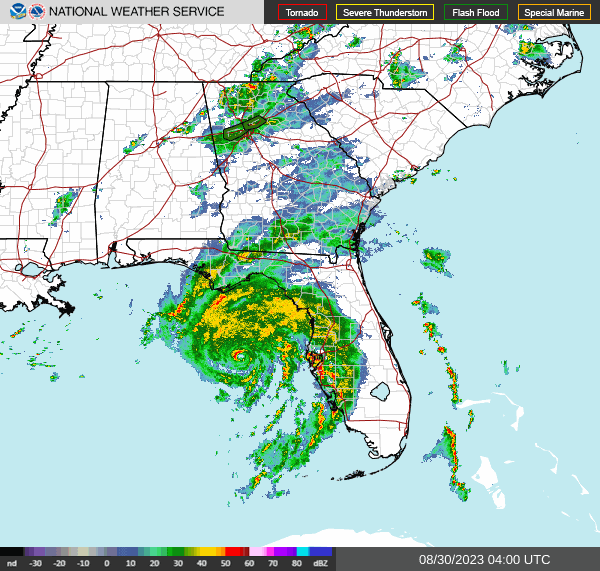
And this storm even looks impressive on radar. Notice that almost the entire west coast of Florida is under a Tornado Watch, because tornadoes can form very quickly in those spiral bands on the Eastern side of a hurricane. 


Tornadoes associated with hurricanes tend to happen fast and be short-lived. Remember that in a Tornado Warning, you need to move to a small interior room on the lowest floor of a sturdy house or other strong building that is not a mobile home. Even places that do not see hurricane impacts or flooding may have a low risk of seeing a tornado out of this, or some minor wind damage from just strong gusts out of some of these rain bands from a rather powerful hurricane. 

363 

WTNT35 KNHC 300256

TCPAT5


BULLETIN

Hurricane Idalia Advisory Number  14

NWS National Hurricane Center Miami FL       AL102023

1100 PM EDT Tue Aug 29 2023


...IDALIA STILL STRENGTHENING...

...FORECAST TO BE AN EXTREMELY DANGEROUS CATEGORY 4 INTENSITY AT 

LANDFALL...


SUMMARY OF 1100 PM EDT...0300 UTC...INFORMATION

-----------------------------------------------

LOCATION...27.7N 84.5W

ABOUT 125 MI...200 KM W OF TAMPA FLORIDA

ABOUT 185 MI...300 KM S OF TALLAHASSEE FLORIDA

MAXIMUM SUSTAINED WINDS...110 MPH...175 KM/H

PRESENT MOVEMENT...N OR 10 DEGREES AT 18 MPH...30 KM/H

MINIMUM CENTRAL PRESSURE...958 MB...28.29 INCHES


WATCHES AND WARNINGS

--------------------

CHANGES WITH THIS ADVISORY:


The Tropical Storm Warning for the Dry Tortugas is discontinued,

and the Tropical Storm Watch for the Lower Florida Keys is 

discontinued.


SUMMARY OF WATCHES AND WARNINGS IN EFFECT:


A Storm Surge Warning is in effect for...

* Englewood northward to Indian Pass, including Tampa Bay


A Hurricane Warning is in effect for...

* Middle of Longboat Key northward to Indian Pass, including Tampa

Bay


A Tropical Storm Warning is in effect for...

* Chokoloskee northward to the Middle of Longboat Key

* West of Indian Pass to Mexico Beach

* Sebastian Inlet Florida to Surf City North Carolina


A Storm Surge Watch is in effect for...

* Bonita Beach northward to Englewood, including Charlotte Harbour

* Mouth of the St. Mary's River to South Santee River South

Carolina

* Beaufort Inlet to Drum Inlet North Carolina

* Neuse and Pamlico Rivers North Carolina


A Hurricane Watch is in effect for...

* Mouth of the St. Mary's River to Edisto Beach South Carolina


A Tropical Storm Watch is in effect for...

* North of Surf City North Carolina to the North Carolina/Virginia

border

* Pamlico and Albemarle Sounds


A Hurricane Warning means that hurricane conditions are expected

somewhere within the warning area. Preparations to protect life

and property should be rushed to completion.


A Storm Surge Warning means there is a danger of life-threatening

inundation, from rising water moving inland from the coastline,

during the next 36 hours in the indicated locations. For a

depiction of areas at risk, please see the National Weather

Service Storm Surge Watch/Warning Graphic, available at

hurricanes.gov.  This is a life-threatening situation.  Persons

located within these areas should take all necessary actions to

protect life and property from rising water and the potential for

other dangerous conditions.  Promptly follow evacuation and other

instructions from local officials.


A Tropical Storm Warning means that tropical storm conditions are

expected somewhere within the warning area.


A Storm Surge Watch means there is a possibility of life-

threatening inundation, from rising water moving inland from the

coastline, in the indicated locations during the next 48 hours.

For a depiction of areas at risk, please see the National Weather

Service Storm Surge Watch/Warning Graphic, available at

hurricanes.gov.


A Hurricane Watch means that hurricane conditions are possible

within the watch area.


A Tropical Storm Watch means that tropical storm conditions are

possible within the watch area, generally within 48 hours.


Additional warnings will likely be required tonight or on Wednesday.


For storm information specific to your area in the United

States, including possible inland watches and warnings, please

monitor products issued by your local National Weather Service

forecast office.


DISCUSSION AND OUTLOOK

----------------------

At 1100 PM EDT (0300 UTC), the center of Hurricane Idalia was

located near latitude 27.7 North, longitude 84.5 West. Idalia is

moving toward the north near 18 mph (30 km/h). A northward to

north-northeastward motion is expected through tonight, with

Idalia's center forecast to reach the Big Bend coast of Florida on

Wednesday morning. After landfall, the center of Idalia is forecast

to turn toward the northeast and east-northeast, moving near or

along the coasts of Georgia, South Carolina, and North Carolina late

Wednesday and Thursday.


Hurricane Hunter aircraft data indicate that maximum sustained 

winds are near 110 mph (175 km/h) with higher gusts. Additional 

strengthening is forecast, and Idalia is expected to become a 

major hurricane during the next few hours before it reaches the Big 

Bend coast of Florida. Idalia is likely to still be a hurricane 

while moving across southern Georgia, and possibly when it reaches 

the coast of Georgia or southern South Carolina on Wednesday.


Hurricane-force winds extend outward up to 25 miles (35 km) from the

center and tropical-storm-force winds extend outward up to 160 miles

(260 km).


The estimated minimum central pressure based on Hurricane Hunter 

aircraft observations is 958 mb (28.29 inches).


HAZARDS AFFECTING LAND

----------------------

Key messages for Idalia can be found in the Tropical Cyclone

Discussion under AWIPS header MIATCDAT5 and WMO header WTNT45 KNHC,

and on the web at hurricanes.gov/text/MIATCDAT5.shtml


STORM SURGE:  The combination of a dangerous storm surge and the

tide will cause normally dry areas near the coast to be flooded by

rising waters moving inland from the shoreline.  The water could

reach the following heights above ground somewhere in the indicated

areas if the peak surge occurs at the time of high tide...


Wakulla/Jefferson County line, FL to Yankeetown, FL...12-16 ft

Ochlockonee River, FL to Wakulla/Jefferson County line, FL...8-12 ft

Yankeetown to Chassahowitzka, FL...7-11 ft

Chassahowitzka, FL to Anclote River, FL...6-9 ft

Carrabelle, FL to Ochlockonee River, FL...5-8 ft

Anclote River, FL to Middle of Longboat Key, FL...4-6 ft

Tampa Bay...4-6 ft

Middle of Longboat Key, FL to Englewood, FL...3-5 ft

Indian Pass, FL to Carrabelle, FL...3-5 ft

Englewood, FL to Bonita Beach, FL...2-4 ft

Charlotte Harbor...2-4 ft

Mouth of the St. Mary's River to South Santee, SC...2-4 ft

Beaufort Inlet to Drum Inlet, NC...2-4 ft

Pamlico and Neuse Rivers...2-4 ft

South of Bonita Beach to Chokoloskee, FL...1-3 ft

South Santee, SC to Beaufort Inlet, NC...1-3 ft

Drum Inlet to Duck, NC...1-3 ft

Chokoloskee, FL to East Cape Sable, FL...1-3 ft

Flagler/Volusia County Line, FL to Mouth of St. Mary's River...1-3

ft

Indian Pass to Mexico Beach...1 to 3 ft

Florida Keys...1-2 ft


The deepest water will occur along the immediate coast in areas of

onshore winds, where the surge will be accompanied by large and

dangerous waves.  Surge-related flooding depends on the relative

timing of the surge and the tidal cycle, and can vary greatly over

short distances. For information specific to your area, please see

products issued by your local National Weather Service forecast

office.


WIND:  Hurricane conditions are expected within the hurricane

warning area in Florida early Wednesday morning, with tropical

storm conditions beginning within the next few hours.


Tropical storm conditions will begin within the tropical storm 

warning area along the Florida Gulf coast and the Florida west coast 

soon.


Hurricane conditions are possible within the hurricane watch area

along the coasts of Georgia and South Carolina Wednesday and

Wednesday night.


Tropical storm conditions are expected to begin on Wednesday in the

warning area along the east coast of Florida, Georgia, and South

Carolina, and spread into North Carolina Wednesday night and

Thursday.  Tropical storm conditions are possible within the watch

area in North Carolina by Thursday.


RAINFALL:  Idalia is expected to produce a swath of 4 to 8 inches of 

rainfall with isolated maxima up to 12 inches from the Florida Big 

Bend through central Georgia and South Carolina, and through eastern 

North Carolina into Thursday. These rainfall amounts will lead to 

areas of flash, urban, and moderate river flooding, with locally 

considerable impacts.


SURF:  Swells generated by Idalia are affecting the southwestern

coast of Florida and will spread northward and westward to the

north-central Gulf coast through Wednesday.  These swells are

likely to cause life-threatening surf and rip current conditions.

Please consult products from your local weather office.


TORNADOES: A few tornadoes are possible tonight from the coast of 

west-central Florida northward into the Florida Big Bend region.  

The tornado risk will shift into southeast Georgia and the coastal 

Carolinas on Wednesday.


NEXT ADVISORY

-------------

Next intermediate advisory at 200 AM EDT.

Next complete advisory at 500 AM EDT.


$$

Forecaster Pasch


571 

WTNT25 KNHC 300254

TCMAT5


HURRICANE IDALIA FORECAST/ADVISORY NUMBER  14

NWS NATIONAL HURRICANE CENTER MIAMI FL       AL102023

0300 UTC WED AUG 30 2023


NOTICE... LAND-BASED TROPICAL CYCLONE WATCHES AND WARNINGS ARE NO

LONGER INCLUDED IN THE TROPICAL CYCLONE FORECAST/ADVISORY...(TCM).

CURRENT LAND-BASED COASTAL WATCHES AND WARNINGS CAN BE FOUND IN THE

MOST RECENTLY ISSUED TROPICAL CYCLONE PUBLIC ADVISORY...(TCP).


HURRICANE CENTER LOCATED NEAR 27.7N  84.5W AT 30/0300Z

POSITION ACCURATE WITHIN  15 NM


PRESENT MOVEMENT TOWARD THE NORTH OR  10 DEGREES AT  16 KT


ESTIMATED MINIMUM CENTRAL PRESSURE  958 MB

MAX SUSTAINED WINDS  95 KT WITH GUSTS TO 110 KT.

64 KT....... 20NE  15SE  10SW  10NW.

50 KT....... 50NE  40SE  20SW  20NW.

34 KT.......120NE 140SE  50SW  60NW.

12 FT SEAS..120NE 150SE  90SW  90NW.

WINDS AND SEAS VARY GREATLY IN EACH QUADRANT.  RADII IN NAUTICAL

MILES ARE THE LARGEST RADII EXPECTED ANYWHERE IN THAT QUADRANT.


REPEAT...CENTER LOCATED NEAR 27.7N  84.5W AT 30/0300Z

AT 30/0000Z CENTER WAS LOCATED NEAR 26.9N  84.7W


FORECAST VALID 30/1200Z 30.0N  83.9W...ON COAST

MAX WIND 115 KT...GUSTS 140 KT.

64 KT... 25NE  25SE  15SW  15NW.

50 KT... 50NE  50SE  25SW  25NW.

34 KT...100NE 160SE  60SW  60NW.


FORECAST VALID 31/0000Z 32.3N  81.3W...INLAND

MAX WIND  70 KT...GUSTS  85 KT.

64 KT... 15NE  15SE   0SW   0NW.

50 KT... 30NE  30SE  20SW  15NW.

34 KT... 90NE 170SE  50SW  30NW.


FORECAST VALID 31/1200Z 33.5N  78.6W...OVER WATER

MAX WIND  50 KT...GUSTS  60 KT.

50 KT... 30NE  30SE  20SW   0NW.

34 KT...110NE 160SE  80SW  30NW.


FORECAST VALID 01/0000Z 33.8N  75.0W

MAX WIND  50 KT...GUSTS  60 KT.

50 KT... 30NE  30SE  30SW   0NW.

34 KT...150NE 100SE 100SW  80NW.


FORECAST VALID 01/1200Z 33.5N  72.5W

MAX WIND  50 KT...GUSTS  60 KT.

34 KT...120NE  70SE  80SW  90NW.


FORECAST VALID 02/0000Z 32.9N  71.0W

MAX WIND  45 KT...GUSTS  55 KT.

34 KT...130NE  50SE  80SW 120NW.


EXTENDED OUTLOOK. NOTE...ERRORS FOR TRACK HAVE AVERAGED NEAR 125 NM

ON DAY 4 AND 175 NM ON DAY 5...AND FOR INTENSITY NEAR 15 KT EACH DAY


OUTLOOK VALID 03/0000Z 32.0N  69.4W

MAX WIND  45 KT...GUSTS  55 KT.


OUTLOOK VALID 04/0000Z 31.0N  68.4W

MAX WIND  45 KT...GUSTS  55 KT.


REQUEST FOR 3 HOURLY SHIP REPORTS WITHIN 300 MILES OF 27.7N  84.5W


INTERMEDIATE PUBLIC ADVISORY...WTNT35 KNHC/MIATCPAT5...AT 30/0600Z


NEXT ADVISORY AT 30/0900Z


$$

FORECASTER PASCH


323 

FONT15 KNHC 300256

PWSAT5


HURRICANE IDALIA WIND SPEED PROBABILITIES NUMBER  14                

NWS NATIONAL HURRICANE CENTER MIAMI FL       AL102023               

0300 UTC WED AUG 30 2023                                            


AT 0300Z THE CENTER OF HURRICANE IDALIA WAS LOCATED NEAR LATITUDE   

27.7 NORTH...LONGITUDE 84.5 WEST WITH MAXIMUM SUSTAINED WINDS NEAR  

95 KTS...110 MPH...175 KM/H.                                        


Z INDICATES COORDINATED UNIVERSAL TIME (GREENWICH)                  

   ATLANTIC STANDARD TIME (AST)...SUBTRACT 4 HOURS FROM Z TIME      

   EASTERN  DAYLIGHT TIME (EDT)...SUBTRACT 4 HOURS FROM Z TIME      

   CENTRAL  DAYLIGHT TIME (CDT)...SUBTRACT 5 HOURS FROM Z TIME      


WIND SPEED PROBABILITY TABLE FOR SPECIFIC LOCATIONS                 


CHANCES OF SUSTAINED (1-MINUTE AVERAGE) WIND SPEEDS OF AT LEAST     

   ...34 KT (39 MPH... 63 KM/H)...                                  

   ...50 KT (58 MPH... 93 KM/H)...                                  

   ...64 KT (74 MPH...119 KM/H)...                                  

FOR LOCATIONS AND TIME PERIODS DURING THE NEXT 5 DAYS               


PROBABILITIES FOR LOCATIONS ARE GIVEN AS OP(CP) WHERE               

    OP  IS THE PROBABILITY OF THE EVENT BEGINNING DURING            

        AN INDIVIDUAL TIME PERIOD (ONSET PROBABILITY)               

   (CP) IS THE PROBABILITY OF THE EVENT OCCURRING BETWEEN           

        00Z WED AND THE FORECAST HOUR (CUMULATIVE PROBABILITY)      


PROBABILITIES ARE GIVEN IN PERCENT                                  

X INDICATES PROBABILITIES LESS THAN 1 PERCENT                       

PROBABILITIES FOR 34 KT AND 50 KT ARE SHOWN AT A GIVEN LOCATION WHEN

THE 5-DAY CUMULATIVE PROBABILITY IS AT LEAST 3 PERCENT.             

PROBABILITIES FOR 34...50...64 KT SHOWN WHEN THE 5-DAY              

64-KT CUMULATIVE PROBABILITY IS AT LEAST 1 PERCENT.                 


  - - - - WIND SPEED PROBABILITIES FOR SELECTED LOCATIONS - - - -   


               FROM    FROM    FROM    FROM    FROM    FROM    FROM 

  TIME       00Z WED 12Z WED 00Z THU 12Z THU 00Z FRI 00Z SAT 00Z SUN

PERIODS         TO      TO      TO      TO      TO      TO      TO  

             12Z WED 00Z THU 12Z THU 00Z FRI 00Z SAT 00Z SUN 00Z MON


FORECAST HOUR    (12)   (24)    (36)    (48)    (72)    (96)   (120)

- - - - - - - - - - - - - - - - - - - - - - - - - - - - - - - - - - 

LOCATION       KT                                                   


WALLOPS CDA    34  X   X( X)   X( X)   1( 1)   1( 2)   X( 2)   1( 3)


OCEANA NAS VA  34  X   X( X)   1( 1)   2( 3)   2( 5)   X( 5)   X( 5)


CAPE HATTERAS  34  X   X( X)   3( 3)  15(18)   5(23)   X(23)   X(23)

CAPE HATTERAS  50  X   X( X)   X( X)   2( 2)   1( 3)   1( 4)   X( 4)


FAYETTEVILLE   34  X   1( 1)   3( 4)   X( 4)   X( 4)   X( 4)   X( 4)


CHERRY PT NC   34  X   1( 1)   2( 3)   7(10)   1(11)   X(11)   1(12)


NEW RIVER NC   34  X   1( 1)   7( 8)  22(30)   2(32)   X(32)   X(32)

NEW RIVER NC   50  X   X( X)   X( X)   4( 4)   X( 4)   X( 4)   X( 4)


MOREHEAD CITY  34  X   2( 2)   8(10)  20(30)   1(31)   X(31)   1(32)

MOREHEAD CITY  50  X   X( X)   X( X)   4( 4)   X( 4)   X( 4)   X( 4)


SURF CITY NC   34  X   2( 2)  21(23)  14(37)   1(38)   X(38)   X(38)

SURF CITY NC   50  X   X( X)   2( 2)   3( 5)   X( 5)   X( 5)   X( 5)


WILMINGTON NC  34  X   1( 1)  13(14)   6(20)   1(21)   X(21)   X(21)


BALD HEAD ISL  34  X   4( 4)  41(45)   8(53)   1(54)   X(54)   X(54)

BALD HEAD ISL  50  X   X( X)   7( 7)   3(10)   X(10)   X(10)   X(10)

BALD HEAD ISL  64  X   X( X)   1( 1)   X( 1)   X( 1)   X( 1)   X( 1)


FLORENCE SC    34  X   5( 5)  17(22)   X(22)   X(22)   X(22)   X(22)


COLUMBIA SC    34  X  14(14)   5(19)   X(19)   X(19)   X(19)   X(19)


LITTLE RIVER   34  X   7( 7)  45(52)   3(55)   X(55)   X(55)   X(55)

LITTLE RIVER   50  X   X( X)   9( 9)   1(10)   X(10)   X(10)   X(10)

LITTLE RIVER   64  X   X( X)   2( 2)   X( 2)   X( 2)   X( 2)   X( 2)


MYRTLE BEACH   34  X  12(12)  48(60)   3(63)   X(63)   X(63)   X(63)

MYRTLE BEACH   50  X   1( 1)  12(13)   1(14)   X(14)   X(14)   X(14)

MYRTLE BEACH   64  X   X( X)   2( 2)   X( 2)   X( 2)   X( 2)   X( 2)


GEORGETOWN SC  34  X  13(13)  46(59)   1(60)   X(60)   X(60)   X(60)

GEORGETOWN SC  50  X   X( X)   6( 6)   X( 6)   X( 6)   X( 6)   X( 6)


CHARLESTON SC  34  1  70(71)  17(88)   1(89)   X(89)   X(89)   X(89)

CHARLESTON SC  50  X  11(11)  31(42)   X(42)   X(42)   X(42)   X(42)

CHARLESTON SC  64  X   1( 1)   7( 8)   X( 8)   X( 8)   X( 8)   X( 8)


BEAUFORT MCAS  34  2  89(91)   4(95)   X(95)   X(95)   X(95)   X(95)

BEAUFORT MCAS  50  X  48(48)  15(63)   X(63)   X(63)   X(63)   X(63)

BEAUFORT MCAS  64  X  11(11)   6(17)   X(17)   X(17)   X(17)   X(17)


AUGUSTA GA     34  1  27(28)   X(28)   X(28)   X(28)   X(28)   X(28)


SAVANNAH GA    34  1  93(94)   1(95)   X(95)   X(95)   X(95)   X(95)

SAVANNAH GA    50  X  48(48)   2(50)   X(50)   X(50)   X(50)   X(50)

SAVANNAH GA    64  X   4( 4)   X( 4)   X( 4)   X( 4)   X( 4)   X( 4)


KINGS BAY GA   34 34  64(98)   X(98)   X(98)   X(98)   X(98)   X(98)

KINGS BAY GA   50  1  32(33)   X(33)   X(33)   X(33)   X(33)   X(33)

KINGS BAY GA   64  X   6( 6)   X( 6)   X( 6)   X( 6)   X( 6)   X( 6)


WAYCROSS GA    34 48  51(99)   X(99)   X(99)   X(99)   X(99)   X(99)

WAYCROSS GA    50  1  73(74)   X(74)   X(74)   X(74)   X(74)   X(74)

WAYCROSS GA    64  X  28(28)   X(28)   X(28)   X(28)   X(28)   X(28)


MAYPORT NS FL  34 32  64(96)   X(96)   X(96)   X(96)   X(96)   X(96)

MAYPORT NS FL  50  1  13(14)   X(14)   X(14)   X(14)   X(14)   X(14)

MAYPORT NS FL  64  X   2( 2)   X( 2)   X( 2)   X( 2)   X( 2)   X( 2)


JACKSONVILLE   34 37  59(96)   X(96)   X(96)   X(96)   X(96)   X(96)

JACKSONVILLE   50  X  13(13)   X(13)   X(13)   X(13)   X(13)   X(13)

JACKSONVILLE   64  X   2( 2)   X( 2)   X( 2)   X( 2)   X( 2)   X( 2)


GAINESVILLE FL 34 86  11(97)   X(97)   X(97)   X(97)   X(97)   X(97)

GAINESVILLE FL 50  3   2( 5)   X( 5)   X( 5)   X( 5)   X( 5)   X( 5)


DAYTONA BEACH  34  7   5(12)   X(12)   X(12)   X(12)   X(12)   X(12)


THE VILLAGES   34 42   4(46)   X(46)   X(46)   X(46)   X(46)   X(46)


ORLANDO FL     34  4   1( 5)   X( 5)   X( 5)   X( 5)   X( 5)   X( 5)


COCOA BEACH FL 34  2   2( 4)   1( 5)   X( 5)   X( 5)   X( 5)   X( 5)


PATRICK AFB    34  2   2( 4)   1( 5)   X( 5)   X( 5)   X( 5)   X( 5)


FT PIERCE FL   34  2   1( 3)   X( 3)   X( 3)   X( 3)   X( 3)   X( 3)


VENICE FL      34 64   X(64)   X(64)   X(64)   X(64)   X(64)   X(64)


TAMPA FL       34 92   X(92)   X(92)   X(92)   X(92)   X(92)   X(92)


CEDAR KEY FL   34 99   X(99)   X(99)   X(99)   X(99)   X(99)   X(99)

CEDAR KEY FL   50 21   X(21)   X(21)   X(21)   X(21)   X(21)   X(21)

CEDAR KEY FL   64  2   X( 2)   X( 2)   X( 2)   X( 2)   X( 2)   X( 2)


TALLAHASSEE FL 34 91   1(92)   X(92)   X(92)   X(92)   X(92)   X(92)

TALLAHASSEE FL 50 36   2(38)   X(38)   X(38)   X(38)   X(38)   X(38)

TALLAHASSEE FL 64 13   5(18)   X(18)   X(18)   X(18)   X(18)   X(18)


ST MARKS FL    34 98   X(98)   X(98)   X(98)   X(98)   X(98)   X(98)

ST MARKS FL    50 58   2(60)   X(60)   X(60)   X(60)   X(60)   X(60)

ST MARKS FL    64 33   1(34)   X(34)   X(34)   X(34)   X(34)   X(34)


APALACHICOLA   34 77   X(77)   X(77)   X(77)   X(77)   X(77)   X(77)

APALACHICOLA   50 12   X(12)   X(12)   X(12)   X(12)   X(12)   X(12)

APALACHICOLA   64  3   X( 3)   X( 3)   X( 3)   X( 3)   X( 3)   X( 3)


GFMX 290N 850W 34 94   X(94)   X(94)   X(94)   X(94)   X(94)   X(94)

GFMX 290N 850W 50 12   X(12)   X(12)   X(12)   X(12)   X(12)   X(12)

GFMX 290N 850W 64  2   X( 2)   X( 2)   X( 2)   X( 2)   X( 2)   X( 2)


PANAMA CITY FL 34 18   2(20)   X(20)   X(20)   X(20)   X(20)   X(20)


BERMUDA        34  X   X( X)   X( X)   X( X)   1( 1)   4( 5)   4( 9)


$$                                                                  

FORECASTER PASCH                                                    


000

WTNT45 KNHC 300259

TCDAT5


Hurricane Idalia Discussion Number  14

NWS National Hurricane Center Miami FL       AL102023

1100 PM EDT Tue Aug 29 2023


Satellite and NWS radar imagery show that Idalia is becoming 

increasingly more organized.  The eye on the Tampa WSR-88D is 

becoming better defined and the cloud pattern on GOES 16 imagery 

consists of a growing Central Dense Overcast with a strong 

convective band over the eastern semicircle of the circulation.  

Reconnaissance aircraft measurements show that the central pressure 

is steadily falling and is now around 958 mb.  Flight-level and 

SFMR-observed winds along with Doppler velocity data from the 

aircraft support an intensity of 95 kt for this advisory.


Idalia is now moving faster toward the north or slightly east of 

north with a motion estimate of 010/16 kt. The hurricane is moving 

between a mid-level trough over the northwestern Gulf of Mexico and 

ridge over the Bahamas and Greater Antilles.  The system is expected 

to turn north-northeastward within the next 12 hours, make landfall 

along the northeastern Gulf coast, and then move northeastward to 

eastward on the southern side of a mid-level trough moving off the 

northeast U.S. coast.  The 12-hour track forecast point for this 

advisory has been nudged a bit westward, a little west of the model 

consensus, but close to the latest GFS and ECMWF solutions.  It 

should be noted that some credible models, i.e. the HAFS-A and 

HAFS-B predictions, are even a little father west.


After landfall, Idalia is expected to move near or along the coast 

of Georgia and the Carolinas in 24-36 hours.  Uncertainty in the 

track forecast beyond 48 hours remains quite large, with some of 

the global models turning Idalia southward, while some of the 

regional hurricane models show the storm moving out to sea.  Given 

the uncertainties, the official track forecast shows a slow 

southeastward motion in 4 to 5 days.


Based on the current strengthening trend and the favorable 

thermodynamic and oceanic conditions, significant strengthening 

seems likely up to landfall.  The new official intensity forecast 

calls for Idalia to reach category 4 strength at landfall.  This is 

fairly close to the HAFS And HWRF regional hurricane model 

simulations.  After the center moves back over the Atlantic, 

significant restrengthening is not anticipated at this time due to 

the expectation of strong vertical west-southwesterly vertical wind 

shear.


Dangerous winds are likely to spread well inland near the path of 

Idalia due to its relatively fast forward motion.


KEY MESSAGES:


1. Catastrophic impacts from storm surge inundation of 12 to 16 feet 

above ground level and destructive waves are expected somewhere 

between the Wakulla/Jefferson County line and Yankeetown, Florida. 

Life-threatening storm surge inundation is likely elsewhere along 

portions of the Florida Gulf Coast where a Storm Surge Warning is in 

effect. Residents in these areas should follow any advice given by 

local officials.


2. There is the potential for destructive life-threatening winds

where the core of Idalia moves onshore in the Big Bend region of

Florida, with hurricane conditions expected elsewhere in portions of

the Hurricane Warning area along the Florida Gulf Coast. Strong

winds will also spread inland across portions of northern Florida

and southern Georgia near the track of the center of Idalia where

Hurricane Warnings are in effect. Residents in these areas should be

prepared for long-duration power outages. Damaging hurricane-force

winds are possible in portions of eastern Georgia and southeastern

South Carolina where Hurricane Watches are in effect.


3. Areas of flash, urban, and moderate river flooding, with locally

considerable impacts, are expected across the Florida Big Bend,

central Georgia and South Carolina, through eastern North Carolina

into Thursday.


FORECAST POSITIONS AND MAX WINDS


INIT  30/0300Z 27.7N  84.5W   95 KT 110 MPH

 12H  30/1200Z 30.0N  83.9W  115 KT 130 MPH...ON COAST

 24H  31/0000Z 32.3N  81.3W   70 KT  80 MPH...INLAND

 36H  31/1200Z 33.5N  78.6W   50 KT  60 MPH...OVER WATER

 48H  01/0000Z 33.8N  75.0W   50 KT  60 MPH

 60H  01/1200Z 33.5N  72.5W   50 KT  60 MPH

 72H  02/0000Z 32.9N  71.0W   45 KT  50 MPH

 96H  03/0000Z 32.0N  69.4W   45 KT  50 MPH

120H  04/0000Z 31.0N  68.4W   45 KT  50 MPH


$$

Forecaster Pasch

Staying Mostly Sunny and Warm, Rain Pretty Scarce Through Next Week

FORECAST: Friday (High 81, Low 59): Partly to mostly sunny. Warm and breezy. Saturday (High 82, Low 61): Mostly sunny. Warm and breezy.  Sun...