

Thursday (High 83, Low 60): Sunny. Mild and dry.
Friday (High 81, Low 64): Mostly sunny. An isolated shower or thunderstorm is possible.
Saturday (High 82, Low 65): Mostly sunny. An isolated shower or thunderstorm is possible, mainly in the morning.
Sunday (High 85, Low 63): Sunny.
Labor Day (High 86, Low 62): Sunny.
Tuesday (High 88, Low 63): Sunny.
Wednesday (High 90, Low 66): Sunny.
Today was sunny and breezy in the Tennessee Valley. The High in Cullman was 84, and the Low was 68. In Jasper the High was 90, and the Low was 70. Haleyville saw a High of 86 and a Low of 65.
.gif)


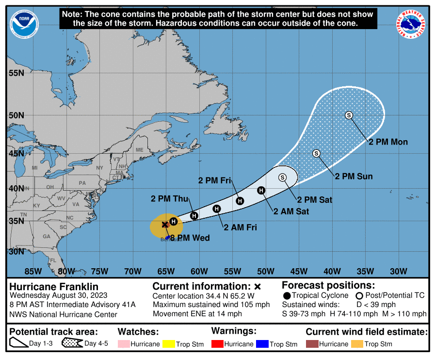
So Tropical Storm Idalia has moved into the Carolinas already, where they are dealing with some flash flooding issues as I write this about 8:30 PM on Wednesday night. They also had a tornado today, I saw. There were a lot of tornado warnings today in Georgia and back in Florida in the spiral bands, but it takes a while to confirm all the damage sometimes with a major weather event like this.
If you know anybody in Florida who may be in need of rescue or is unaccounted for, then the best one-stop site seems to be https://www.floridadisaster.org/. I know there has been a lot of property damage, but in a situation like this, you have to prioritize making sure everybody is alive and taken care of if they've suffered injury, and then worry about the property later. So far, three deaths have been reported with this hurricane. There were two car crashes that happened because of the weather in Florida where people did not make it. And then there was a tree that fell on someone in Georgia. But as of right now, as bad as the storm surge was in some places, no deaths have been reported in Florida related to the hurricane directly, like the winds or the rain. Here is a CNN story about that. If it stays that way, then we have to consider this a good outcome, for a storm that was as strong and damaging as this one. Of course it is ideal if we see no loss of life, but that hardly ever happens. Realistically, having "only" three fatalities out of a major hurricane like this is about as good as it is going to get, with the current state of how people understand and react to forecasts, plus some people not having great access to shelters near their homes.
Tomorrow will be sunny around here with a High near 83, Low near 60 tonight/tomorrow morning. Then on Friday, an inverted trough and some Southeast winds aloft may bring us enough Gulf moisture for a low chance of rain, about 20%, which is just really isolated showers or thunderstorms in the region. The High should be near 80 and the Low more toward about 64 or 65 due to a temporary increase in moisture and then clouds during the day. And the weather looks similar for Saturday, High in lower 80's and Low in mid-60's. Will keep that 20% chance for an isolated shower or thunderstorm in there. Could also see isolated rain overnight between the two days.
Then by Sunday the ridge of high pressure starts to build back over our region with a High in the mid-80's, Low may drop back into lower 60's with drier air again. Then Monday, Labor Day, that pattern continues, and the High may ease back into the upper 80's, Low may not get out of lower 60's still, humidity levels will stay low. Then Tuesday definitely a High in upper 80's, the Low might be more in mid-60's, but close call as to how much that Low temperature rebounds since the air looks to stay so dry. And then next Wednesday, we stay sunny under a good strong high pressure ridge holding over the region, with a High near 90, Low probably only in the mid-60's. The extended forecast here looks like plenty of sunshine but a break from the serious heat, and even more of a break from the humidity. We are about to be into September.

As we all know, the tropics are active right now. That tropical depression (Eleven) is going to peter out in another couple days over the water. That disturbance near it that you see with the yellow X looks inconsequential as well. That orange X marks a disturbance near the Cabo Verde Islands that does need to be watched and will probably become a tropical depression within the next couple days or so.


No comments:
Post a Comment