

(Forecast)
Sunday (High 80, Low 63): An isolated, lingering shower is possible in the morning. Becoming mostly sunny.
Monday (High 78, Low 56): Sunny. Mild and dry.
Tuesday (High 79, Low 54): Sunny. Mild and dry.
(Extended Outlook)
Wednesday (High 81, Low 57): Mostly sunny.
Thursday (High 80, Low 59): Mostly sunny.
Friday (High 81, Low 60): Mostly sunny.
Saturday (High 80, Low 61): Partly cloudy with a 20% chance of a shower or thunderstorm.
(Beach Forecast)
Sunday (High 87, Low 73): Mostly sunny with an isolated shower or thunderstorm possible.
Monday (High 89, Low 69): Sunny.
Tuesday through Rest of Week (Highs in upper 80's, Lows in upper 60's): Mostly sunny.
(Pronóstico)
Domingo (Máxima 80, Mínima 63): Es posible una lluvia aislada y persistente por la mañana. Volviéndose mayormente soleado.
Lunes (Máxima 78, Mínima 56): Soleado. Suave y seco.
Martes (Máxima 79, Mínima 54): Soleado. Suave y seco.
(Perspectiva Extendida)
Miércoles (Máxima 81, Mínima 57): Mayormente soleado.
Jueves (Máxima 80, Mínima 59): Mayormente soleado.
Viernes (Máxima 81, Mínima 60): Mayormente soleado.
Sábado (Máxima 80, Mínima 61): Parcialmente nublado con un 20 % de probabilidad de lluvia o tormenta eléctrica.
(Pronóstico de la Playa)
Domingo (Máxima 87, Mínima 73): Mayormente soleado con posible lluvia o tormenta aislada.
Lunes (Máxima 89, Mínima 69): Soleado.
De martes a resto de la semana (Máximas en los 80 grados superiores, Mínimas en los 60 grados superiores): Mayormente soleado.
(Notes)
The National Weather Services serving Tennessee have all put together a weather safety page in English and in Spanish. If anyone has any feedback or suggestions for my attempts at bilingual forecasts on here, feel free to leave a comment.
It is good to have a hurricane safety plan in case you find yourself at a beach when a tropical storm or hurricane is approaching this time of year. But you're much more likely to encounter rip currents, so here is some advice on how to stay safe in those.
The National Weather Service in Birmingham has scheduled SKYWARN classes ahead of our November peak in severe weather. And the Nashville office is offering some Weather Safety Basics classes.
Today is the anniversary of Hurricane Ivan.
And in more recent memory we had Hurricane Sally only three years ago.


At 10 AM many of us are overcast in the Tennessee Valley today, this Saturday. Actually got some fog and mist taking visibility down to 2 miles in Cullman, temperature of 70 degrees. Dewpoint is the same, making the relative humidity 100%. Winds are from the Southeast at 5 miles per hour. The pressure is 30.05 inches and steady. The Low this morning was 68. It is overcast in Jasper, but the visibility there is still at 10 miles, temperature of 73, 73 degree dewpoint, relative humidity of 100%. Winds are calm. Pressure is 30.02 inches and steady. Low there was 70 this morning. Haleyville is overcast with the visibility down to 7 miles. Temperature is 71, same dewpoint, 100% humidity there too. Winds are from the South at 5 mph. Pressure is 30.05 inches or 1016.4 millibars and steady.
Elsewhere around the region, Gadsden is overcast and 70 degrees. Fort Payne is at 67 with light rain and fog. Huntsville has drizzle and fog at 70 degrees, visibility down to 5 miles. It's down to 9 miles in Ft. Payne BTW. Overcast and 71, visibility of 8 miles in Decatur. Fayetteville has fog and 68 degrees, visibility down to 2 miles. Winchester has a visibility of only 1.25 miles, foggy and 68 degrees. The driving could be rough in some of these places.
Then some of the other cities spread out in the region: Birmingham is overcast and 73 degrees, but great visibility of 10 miles. Atlanta has light rain and 70 degrees, visibility of 8 miles. Light rain and 68 degrees in Nashville, visibility of 9 miles up there. Memphis is mostly sunny and 77 degrees, perfect visibility. Also great visibility of 10 miles for Tupelo even though they are mostly cloudy and 80 degrees at this hour.
The showers we've got hanging around right now are associated with a shortwave trough out ahead of this cold front. The frontal boundary is weak and won't impact our local temperatures much besides drying the air out behind it, allowing for more cooling at night, so morning temperatures will come down some.
The High today should only get up to about 78 with off-and-on scattered showers.


Then the high pressure moves in behind the frontal boundary on Monday. The High should dip into the upper 70's despite plenty of sunshine, and the Low due to the much drier air, should be in the upper 50's, maybe even mid-50's.

And that pattern holds for Tuesday, might see the High closer to 80 again, but Low should be toward the mid-50's with ideal radiational cooling possible at night.


On Wednesday as the center of high pressure starts to shift toward the East, we should still have mostly sunny skies here, High of 80 or so, Low in upper 50's.


And then again on Thursday, mostly sunny skies, High near 80, Low near 60. The Low temperatures will gradually rebound each day as we get a little more moisture return until the next pattern change.


Friday still looks mostly sunny with a High around 80, Low roughly around 60.


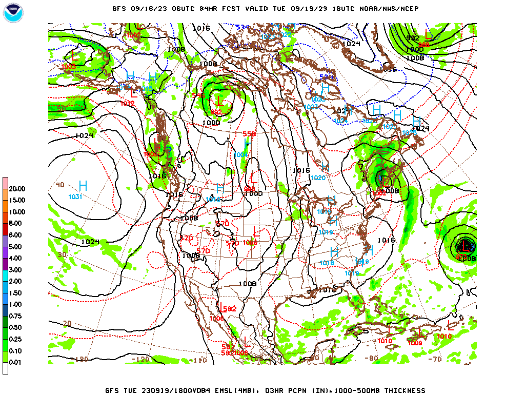
Then for Saturday the American model has us dry under high pressure still.

Sharp contrast with the European model, which definitely has some rain chances around here again.
To account for that uncertainty, will include a 20% chance of isolated rain for Saturday. Not a whole lot of temperature change.
And Saturday the 23rd is actually the autumnal equinox. The guidance 7-10 days is messy, and I'm not sure we'll feel Fall coming in in a strong way in a hurry. The guidance even has a tropical system climbing up the East Coast, but that too is dicey and messy, may be gone on the next couple of model runs, whole idea could be gone.

The tropics are somewhat active here in the real world though.


Tropical Storm Fifteen is expected to track East of Bermuda, probably posing no threat to land even though it reaches hurricane strength. But as always, good to keep an eye on it in case the track changes.


Tropical Storm Margot is expected to meander over open water and continue to weaken over this coming week and become post-tropical later in the week before it moves toward the Azores. They will probably get tropical depression level impacts, if that.


Post-Tropical Cyclone Lee has prompted Tropical Storm Warnings and Hurricane Watches along the coast of Maine and up through parts of Southeast Canada such as Nova Scotia. The winds are right on the borderline of being tropical storm force or hurricane force. Most places will probably see tropical storm impacts from this. We really dodged a bullet with this as far as it not hitting any land directly while it was at its peak strength. But this happens with a lot of powerful hurricanes. And the models picked up on it well in advance. I was being overly cautious watching this one. And it turned out all right.

Rainfall totals for this forecast period will probably stay under a half-inch or even a quarter-inch for most of us. And most of the rain will be over today. We might see some more next Saturday, but that's dicey.


No comments:
Post a Comment