


They are giving plenty of lead time on this cluster of storms and for good reason. They have a history of producing large hail and some wind damage to trees and power lines.
6:03 PM - I notice they are trending back toward estimating the hail at quarter size. Still estimating winds up to 70 mph though, plenty enough to damage trees and power lines. And the hail size has fluctuated up and down as these storms have pushed south out of Tennessee today. So that could ramp back up. And sometimes around sundown, storms do that. So either way, please be careful, be in a good safe place, definitely don't be trying to drive through this kind of weather.

6:06 - Storms moving into Nauvoo.
Storm damage at Ashridge in Winston County… photo from Justin Henderson pic.twitter.com/Db8Kz7pxnJ
— James Spann (@spann) June 29, 2023
And this report is worth passing along because these storms continue to do damage. They were damaging up in Tennessee, and they have sustained into Alabama.

6:12 - The public reported the hail at half-dollar size in Double Springs. Guess that's better than golfball. Looks like they are dropping the Severe Thunderstorm Watch for areas further North in Alabama and up into Tennessee. We've just got these couple of storm clusters that are still severe in Northwest Alabama.

6:15 - A new storm has formed and intensified South of the main storm there in Walker County, actually extends over into Fayette County - between Carbon Hill, Oakman, and Berry. This is within the warning polygon and certainly looks severe to me on radar.

6:18 - And those two storms in Winston and Walker Counties are the only ones showing signs of being severe. The warnings for those storms do clip Fayette and Marion Counties as well.
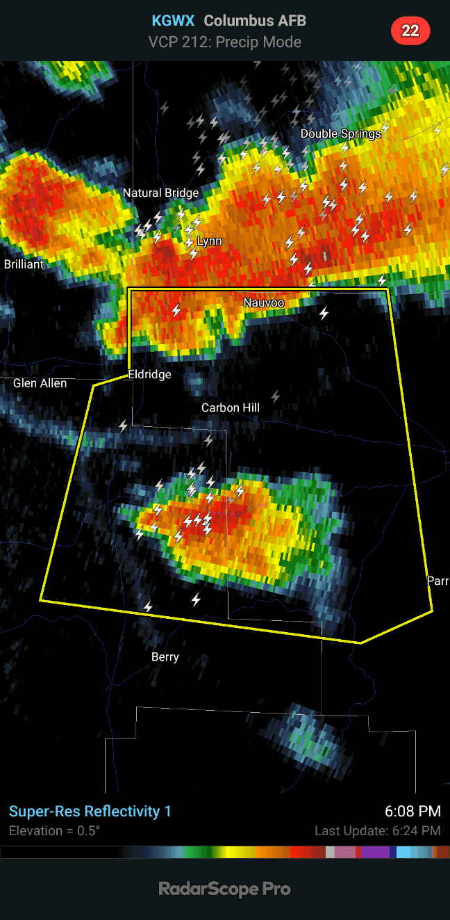
6:23 - And with the latest update to the warning, the National Weather Service in Birmingham is estimating the hail to be up to 1.5 inches in diameter, that's about the size of a ping pong ball. So like I said, the hail in these storms has been cycling up and down today.

6:30 - All right, this is moving down into Southwestern Walker County and more into Fayette and Tuscaloosa Counties. The threats remain ping pong ball sized hail and 60 mph wind gusts. After posting this radar image above, going to leave this be unless weather radio goes off again (like it just did) and be working on the forecast. This is getting more into the area covered by bloggers or other forecasters centered around Birmingham.
7:42 PM - If you've just stumbled on this post as the latest on the blog, see here for the latest forecast. I started writing it before this severe stuff got this far south and finished it after.
515
WUUS54 KBMX 292253
SVRBMX
ALC057-093-127-133-292345-
/O.NEW.KBMX.SV.W.0244.230629T2253Z-230629T2345Z/
BULLETIN - IMMEDIATE BROADCAST REQUESTED
Severe Thunderstorm Warning
National Weather Service Birmingham AL
553 PM CDT Thu Jun 29 2023
The National Weather Service in Birmingham has issued a
* Severe Thunderstorm Warning for...
Walker County in central Alabama...
Southeastern Marion County in northwestern Alabama...
Southern Winston County in northwestern Alabama...
Northeastern Fayette County in west central Alabama...
* Until 645 PM CDT.
* At 553 PM CDT, a severe thunderstorm was located over Poplar
Springs, or 8 miles east of Lynn, moving south at 55 mph.
HAZARD...60 mph wind gusts and quarter size hail.
SOURCE...Radar indicated.
IMPACT...Hail damage to vehicles is expected. Expect wind damage
to roofs, siding, and trees.
* Locations impacted include...
Jasper, Cordova, Carbon Hill, Lynn, Arley, Berry, Parrish, Oakman,
Sipsey, Kansas, Nauvoo, Eldridge, Curry, Camp McDowell, Ashbank,
Poplar Springs, Falls City, Smith Lake, Lynns Park and Coon Creek.
PRECAUTIONARY/PREPAREDNESS ACTIONS...
For your protection move to an interior room on the lowest floor of a
building.
&&
LAT...LON 3399 8714 3397 8714 3396 8712 3391 8709
3390 8710 3389 8708 3381 8702 3367 8738
3371 8774 3402 8771 3402 8757 3412 8722
TIME...MOT...LOC 2253Z 349DEG 49KT 3407 8741
HAIL THREAT...RADAR INDICATED
MAX HAIL SIZE...1.00 IN
WIND THREAT...RADAR INDICATED
MAX WIND GUST...60 MPH
$$
40/Sizemore


No comments:
Post a Comment