Monday (High 53, Low 22): Sunny. Frost in the morning.
Tuesday (High 61, Low 29): Mostly sunny. Staying cold in the morning.
Wednesday (High 70, Low 41): Partly cloudy. An isolated shower cannot be ruled out, especially in Tennessee counties.
Thursday (High 80, Low 53): Partly cloudy.
Friday (High 78, Low 63): Thunderstorms likely - some possibly severe.
Saturday (High 70, Low 54): Clearing early and becoming mostly sunny.
Sunday (High 72, Low 50): Partly to mostly sunny with a 20% chance of a shower.
Looks like we've got another freeze warning tonight. I've been out of the loop for a while, but this is not a paying gig.
Here is a look at the tornadoes that occurred on March 1 and 3rd.
Got a couple of SKYWARN classes coming up this week: First one is Tuesday 6 PM at the Marshall County EMA Office in Guntersville. Then Friday 6 PM in Rainsville, one is scheduled at Northeast Community College in the MT building. That second one is questionable since the weather may get stormy on Friday, sometimes they have to reschedule if that happens. If you've already taken basic SKYWARN training, there is an advanced class being offered online this Thursday evening at 6:30.
If you can't swing any of that, still might be a good time to review severe weather safety rules, as we have a threat coming up Friday and will soon be into the month of April, historically our worst month for severe thunderstorms and tornadoes.
The Montgomery radar is scheduled to stay offline through the end of March. Might affect some people more toward Central and South Alabama.
And Weather101 returns this week, 7 PM Thursday, with the first class being on upper-air data and how it is used in understanding and forecasting the weather. Thanks to the staff in Nashville for putting that on, think it was mainly Scott Unger and Krissy Hurley's idea for a few years now.
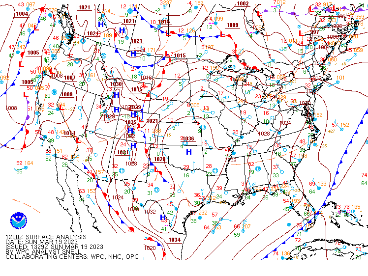
Our upper-air pattern right now plotted on the national maps is showing winds aloft (500 millibars, about 18,000 feet) from the southwest. Which means we will be warming up again soon as those winds bring warmer air from Texas and then from the Gulf of Mexico. This is a trend that has started, not going to happen all in one day. We are still quite cold today.
Generally in the 30's here in the Southeast, then in the 10's as you get into the Ohio Valley and Midwest. High pressure strongly centered over Oklahoma, the Great Plains. High pressure extending back through the Rocky Mountains. Some of those places seeing single digits or even negative numbers for temperatures this morning.
At 10 AM we are locally at 30 degrees in Cullman. Skies are mostly cloudy according to the official observation, but I would call them partly to mostly sunny by looking out the window. Visibility is great, at ten miles. The dewpoint is 16 degrees, making the relative humidity 55%. The main thing is the Northwest wind at 9 miles per hour, with gusts up to 17-18 mph. That makes out wind chill value still down at 22 degrees. There are good reasons the National Weather Service put us all under a freeze warning. Barometric pressure is 30.38 inches and rising. Already mentioned the high pressure system out in the Plains earlier.
Our Low this morning was 25.
It is 34 degrees in Jasper with a wind chill of 29, winds variable there and gusting up to 14 mph. Mostly cloudy skies, had a Low of 27 earlier this morning.
Haleyville only has a few clouds, mostly sunny skies at this hour, 29 degrees, but a Northwest wind of 12 mph making for a wind chill of 19.
It is 32 in Muscle Shoals, also in Huntsville. Gadsden is at 34. Atlanta is at 36. Birmingham 35. Memphis 31. Tupelo 33. Nashville is overcast and 28 degrees. They have actually had some light snow, flurries anyway, this morning, wind chill of 19 degrees.
We'll stay mostly sunny today and get up to maybe 42 or 43 degrees for the High. It will not feel that "warm" though as we will stay breezy.
And tonight, remember to protect pipes, plants, and pets, as well as keeping yourself warm enough. Seriously, this is the kind of cold that starts to get dangerous. And we've had several rounds of it in the past week. I didn't really post updates on it, just forecasted it last week.
Tomorrow that high pressure will move more directly through our region as rain moves back into the Plains, and behind that, snow and a wintry mix into the Rockies and areas North and West of there. About the Eastern third of the country stays dry, including us. Some snow is possible way up there in Maine and neighboring parts of New England and Canada.
Around here skies will be sunny, winds will settle down some, but we will have frost in the morning or even a hard freeze in some places, Low near 22 degrees. And then for the afternoon we'll warm up to about 53-54 degrees.
Then on Tuesday it's questionable whether or not the moisture from the fronts way out West will be enough to bring us back rain chances around here.
Notice how the upper-level winds have taken on a southerly component, not enough for a big warmup yet, but still continuing the pattern of winds shifting back more to the southwest, like we saw on the maps a little bit already today. Lines of wind and pressure follow each other on weather maps.
The GFS is really not showing moisture making it in here though.
And neither is the NAM.
The High will be shifting to the Mid-Atlantic region though. And we'll see a few clouds return, still more sun overall, High near 60 or so, Low near 30. Air still pretty dry.
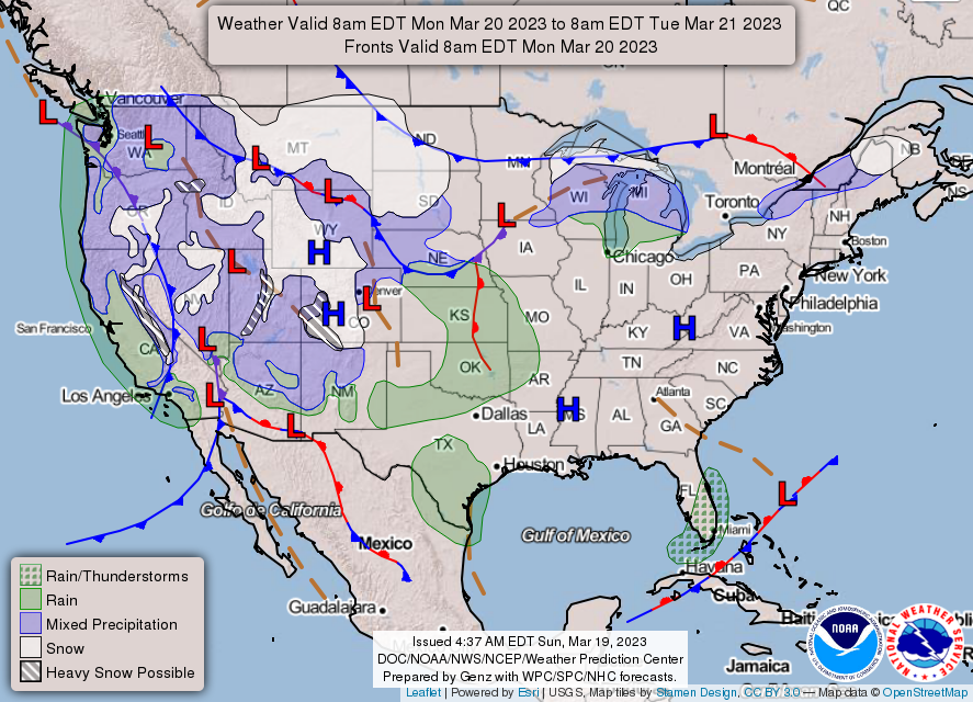
And we probably stay dry on Wednesday as well, although the GFS brings enough moisture in here to support isolated rain chances. The NAM and ECMWF are not showing that, and I doubt it is right. Looks like High will rebound to near 70, Low to lower 40's. If we do see rain, probably will be up in Tennessee counties that border Alabama, and further up into the state of TN.
Thursday is the big warmup, as those upper-level winds really steepen from the Southwest. Expecting a High near 80 after a morning Low rebounding into the lower 50's. We have a lot of drastic pattern changes in just a few days this time of year, late March into early April.
And boy, look at that storm system moving through the Plains ahead of that cold front and upper-level trough.
The Storm Prediction Center has gone ahead and outlooked a basic 15% risk of severe weather for much of Oklahoma and mainly North Central Texas, risk also extends into far Western Arkansas for Thursday evening/night.
Then on Friday, that risk extends into the Mississippi and Tennessee River Valley regions, which means us.
Model data tends to fluctuate this far in advance, but as of right now, the GFS is showing pretty decent instability, more than 1,000 joules of surface CAPE, and strong enough wind fields to support severe thunderstorms at both 1 km and 3 km up into atmosphere. If this trend were to hold then the tornado threat would be on the lower side for this setup, but this time of year, you can't really make that call this far in advance. This is looking like a threat more for large hail and some damaging thunderstorm winds, but of course if concerned with this, you should keep an eye on the latest forecasts over the next few days as we get closer to whatever it is going to do.
Synoptically it does look like an impressive storm system.
On the ECMWF as well as the GFS model guidance. The Euro is a little bit slower, which is typical.
The European is showing dewpoints getting up into the 60's, well into the zone we'd look for to support severe weather, by 1 PM on Friday. It looks like the air will be unstable enough. And this front looks like enough lift, position of the Low pressure looks favorable for severe weather. The deciding factor for how much of a tornado threat we have versus just a severe thunderstorm threat will be the wind shear at different levels and how well it coincides with these other two things. Whether it is more of a routine severe weather threat or ends up being a bigger threat for something more organized, it pays to be prepared this time of year.
Anyway thunderstorms are likely on Friday, some could become severe, feel okay about putting that into official forecast already, High should be in upper 70's and Low in lower 60's.
Then on Saturday we clear out again with the front departing and high pressure moving in from the Midwest. Think we see mostly sunny skies overall, High near 70, Low in lower 50's. Could see a lingering shower or two early, looks like that sort of a pattern.
Similar temperatures on Sunday of next week, and I know the WPC guidance here is showing moisture ahead of that frontal system out in the Plains. But looking at the global models and this overall pattern, I think we will probably stay dry with only an increase in clouds at that point.
We'll probably see up to about an inch-and-a-half of total rainfall for this forecast period. Most of that, probably all of it, will be on Friday.


No comments:
Post a Comment