(Forecast)
Friday (High 81): Variably cloudy, windy and muggy during the day. At night, thunderstorms are likely, and some storms may be severe.
Saturday (High 78, Low 62): Rain clearing out quickly in the morning. Becoming mostly sunny and staying breezy.
Sunday (High 79, Low 50): Partly to mostly sunny. Scattered showers and thunderstorms are possible, mainly in the evening and night hours.
(Extended Outlook)
Monday (High 76, Low 55): Partly to mostly sunny with a 30% chance of showers or an isolated thunderstorm.
Tuesday (High 66, Low 51): Partly to mostly sunny with a 20% chance of showers.
Wednesday (High 67, Low 39): Sunny.
Thursday (High 72, Low 44): Partly cloudy.
(Notes)
If you have not done so already, please take the time now to review your severe weather safety plan. And remember the wise words of Kim Klockhow-McCain: Don't let your inability to do things perfectly get in the way of "good enough".
I thought Jim Stefkovich did an excellent job of analyzing this severe weather event in this post for Alabama EMA.
(Discussion)
Writing this at 10:30 PM on Thursday.
Looking first at the radar network, we have a line of rain and thunderstorms moving through the Plains and Midwest mostly. Especially in southern Missouri, still having some problems with flash flooding and some storms trying to go severe, produce damaging winds or large hail.
The sun went down a few hours ago, so we have no visible satellite imagery available, have to go by infrared images. And you can still pick out that cold front and strong storm system affecting the Plains through the Midwest into the Ohio River Valley. It really stands out. On the top image focused on the Southern Region, I picked one that showed lightning strikes as well, because there is a lot of lightning with these storms still moving through Oklahoma and Missouri.
Let's take a look at today's storm reports, because they did have a risk for some severe thunderstorms out there today.
All right, so it wasn't a big severe weather outbreak, and most of the storms that did go severe were "hailers", producing hail usually about the size of quarters, but I note a report from Okemah, Oklahoma of ping-pong-ball-sized hail (one and half-inch in diameter). My Granny would have said, "That'll knock a hole in your head!" But usually she was saying that when it got up to golfball or baseball-sized hail. There were a few isolated instances of damaging winds, one did damage to an outbuilding, but mostly this was tree damage, bringing trees down. So that's what they've dealt with out there from this storm system. Unfortunately it looks like the Mid-South and Southeast United States have drawn the short straw from this system and are going to feel its wrath the most tomorrow and tomorrow night.
We've got strong upper-level winds from the Southwest, and this front approaching. Synoptically, this setup really favors a classic severe weather event.
Let's not forget to look at local conditions along with the big picture here: We are partly cloudy at this hour in Cullman, but with great visibility of 10 miles. The temperature is 70, with a dewpoint-temperature of 57, making the relative humidity 64%. Winds are from the South (imagine that) at 10 miles per hour. The pressure is 30.06 inches and steady. (It will be falling tomorrow.)
We had a High of 82 degrees today after a morning Low of 57. We were breezy at times, variably cloudy throughout the day, but overall saw a lot more sunshine than the clouds.
Jasper saw a High of 84 and a Low of 48. They liked to flip things upside down, frontwards and backwards down that way sometimes. And Haleyville saw a High of 80, Low of 56.
Elsewhere around the region, Fort Payne got up to 81 degrees today, even there at the higher elevation. Gadsden got up to 82. Muscle Shoals only got up to 80 and had a little more cloud cover than some of the rest of us. Huntsville saw a High of 82 at the International Airport. Nashville did not feel the warm snap and only got up to 74 degrees today. They stayed overcast much of the day. Memphis also had a lot of clouds today but got up to 77 degrees. And Tupelo made it up to 84.
We should be fine during the day tomorrow. The storms will initially start firing as supercell thunderstorms over Louisiana, parts of Arkansas, and into Mississippi tomorrow afternoon. And those will carry a really substantial tornado threat. Around here we expect a mix of sun and clouds, High of about 80 again. Actually I'm going to go with a High of 81 for Cullman, accounting for a little more cloudy periods than today. We were at 82 today. Low tonight should be about 62.

Then tomorrow evening, that activity starts to shift further East, and I think a broken squall line of supercell storms will be moving further East into Mississippi. All severe hazards will be possible with those storms, including tornadoes. And please understand that in an environment like this, supercell thunderstorms can produce the kinds of tornadoes that do more damage than the average, and stay on the ground for a while. So if you know anybody back in Mississippi or other places the storms will be forming and moving through in these earlier stages, might want to make sure they know they are in the bullseye for this event.
I think the storms will start to cross the Alabama line around midnight, roughly around midnight.
Especially from the slightly slower timing of the NAM.
And I'll get into details of our severe weather threats at the bottom of this post, separate from the main forecast discussion. But overall by this time, the storms should have formed into at least one squall line. Sometimes you get more than one line of storms. Within that line, some of the storms could still become severe and mainly pose a risk for damaging straight-line winds. But the tornado threat will continue to some extent even as it moves into North Alabama and Southern Middle Tennessee. Squall lines can spin up tornadoes quickly, and those are a real headache during an overnight event like this. And as Mr. Jim Stefkovich mentioned for Alabama EMA (he was the head of NWS Birmingham during the 2011 tornado outbreak, excellent meteorologist), some of the activity in our neck of the woods could be supercellular in nature. You can have supercells embedded within a squall line. Where lines break up, or between two lines of storms, you can have a supercell thunderstorm. And of course, one or two could try to form out ahead of the main squall line of storms. Any storms that get discrete like that, hogging all the energy for themselves, would have the highest tornado potential. But even within the line (or lines), be aware that while the main threat is damaging straight-line winds, some tornado risk does exist. And that's true even if all you get is a severe thunderstorm warning. Tornadoes are tough to confirm at night, even with social media and dual-pol radar. Huntsville had dual-pol (ARMOR) about ten years ahead of the rest of the country, and that was a great thing. But storms at night are tough to know for sure about. So the best we can do is take the radar data seriously, and of course any ground truth reports we can get in real time. Once in a while, a storm can be showing only weak rotation on radar and some strong winds, but still produce a tornado with little to no additional warning in advance. And I could see that happening somewhere in this setup.


The cold front will quickly move through and clear the area Saturday morning. This one is not going to cool us down much though, and after starting the day about 61-62 degrees, we should warm up to about 77-78 in the afternoon, mostly sunny skies, staying breezy behind the front.
Sunday and Monday, I think it's more helpful to show the WPC maps than the raw model output. The models have gone back and forth, but it is now looking like (from GFS, NAM, and ECMWF) the best chance of any more rain and storms during this time period will be over South Alabama, maybe about the southern half of the state.
Around here, I'm only putting in a minimal 20% chance of an isolated shower around here for both days. If we see anything Monday, I'd just about bet on it being early in the day. If anything around here gets a little more organized, probably overnight between Sunday and Monday, but even that, I question, with the model inconsistency and the position of this front, this just doesn't look like another big rainmaker or storm risk to me. Now if you were in Southern Alabama on the warm sector of this front, then you'd have to look out for potential of a few stronger storms. But up this way, not concerned with it.
Should see a High near 79, Low near 50 for Sunday, mostly sunny skies even if we do see a stray shower at some point, probably later in the day or at night. For Monday, mostly sunny again even if we do have a lingering shower early, High more toward mid-70's, but the Low rebounding to about the mid-50's because of the extra moisture overnight. Still not sold on it being a really rainy night around here.
On Tuesday our upper-level wind pattern is staying zonal from the West, and we remain under the influence of high pressure centered over the Midwest and up around the Great Lakes.
If you believe the GFS on this latest run. It has not always been consistent with this look, though I admit I have not kept up with every single run.

The European model, often known for being more reliable in the long-range, shows rain lingering and working its way back northward on Tuesday, bringing rain chances back to our neck of the woods. Will keep a 20% rain chance in there just to cover this major discrepancy in the model output. Though I am leaning toward believing the GFS on this one. Peeked at the Canadian GEM though, and it is more in line with the ECMWF. This is a tricky one. Will be careful with how to balance out rain probabilities between Sunday, Monday, and Tuesday. But think a lingering 20% chance is appropriate for Tuesday. Should see a High in mid-to-upper-60's and a Low near 50. This is when we do start to cool down again behind the front finally. Things stay active this time of year, and small-scale details make a big difference in lots of things, even temperatures.


Then by Wednesday, definitely under the influence of a High pressure system, and will see plenty of sunshine, Highs in mid/upper 60's and Lows down around about 40.
Thursday it looks like a High in the lower 70's, Low in mid-40's before our next storm system, or at least rainmaker, gets here. If we see any rain chances on Thursday, it'll be isolated, and for now I'm leaving it out of the forecast and only mentioning an increase in clouds.

We could see up to an inch or two of average rainfall totals for this forecast period, and especially in far Northwest Alabama into Middle Tennessee, need to keep an eye out for some people having issues with flash flooding, mainly with the event tomorrow night into Saturday morning. Especially if any thunderstorms do get out by themselves and go supercellular, they can dump a lot of rain in a hurry as well as producing the storm damage. Or even line-embedded supercells can do that. If you have to be driving Friday night, please avoid crossing any water that covers a roadway or especially something like a bridge. Stop and turn around if you can safely do so, but do not drive into that water. As far as the severe threat, you need to work out at least three or four places in your mind that you could pull over and get inside if a tornado warning was issued. There may be fewer of those places at night, but there are all-night stores and restaurants, gas stations. Being inside, away from glass doors or windows, is a lot safer than being caught on the roads. Actually in a tornado outbreak (Super Tuesday) in 2008, there was a trucker who survived being sideswiped by an F-4 tornado (those are rare) because he left his vehicle. Even though he did not have time to knock on a door and ask for shelter at someone's house (this was in the early morning hours), he held onto a tree. He did have minor injuries, but his truck was thrown some distance away and destroyed. He lived, and his injuries were not serious or life-threatening. And this guy waited until the last minute to do anything about it, kept hearing about the weather on the radio. So even if you are in a bad situation like that, where you have to drive for work when the weather gets bad, please remember that you do have some options. A lot of people take the attitude, "If it's gonna' get me, I might as well assume my tornado position and kiss my sweet bippie goodbye." And that is not true. There is almost always something you can do to turn the odds very much in your favor. Only about 1-2% of all tornadoes get that violent, to be rated E/F-4. And that guy survived one by getting out of his truck and getting low down to the ground, even though he was outside. Sounds like he only did it in a panic, not as any sort of thought-out plan, and it probably still saved his life.
(Mesoscale Discussion)
So now let's look at the severe weather potential in detail.
The 4 kilometer NAM, one of the models that can be really good for forecasting these short-term mesoscale features, is showing instability, surface-based CAPE values, struggling to get to about 500 joules/kilogram or slightly higher at about 3-4 AM as we go into Saturday morning. Usually this would mean only a marginal threat for severe weather.
But you have to take everything into account.


The wind shear is extremely strong. In fact, this could be another event where some damage occurs outside of specific thunderstorms, because of strong gradient winds. That happens once in a while, just usually not as bad as March 3rd of this year was, it got really bad with that event. You can see that around 3-4 AM is the best timing for the instability and the wind shear to catch each other and really fire some of these storms up and cause them to become severe. It is particularly concerning to see values of over 300 m^2/s^2 of Helicity at the lowest kilometer of the atmosphere. You really only need about 150-200 units to support a tornado risk, and especially with this being such strong low-level rotation, there at the lowest kilometer of the atmosphere, this makes me think that even if it all stays in one squall line, the tornado threat might be nothing to sneeze at. There are values of 400 or even 500 units as you go into Northeast Alabama, and that is crazy-high. You do see that sometimes, and usually the unstable air and these super-high wind shear values manage to miss each other. They are out of phase to get together for a really bad event. But this one is a close call. The instability is marginal, but it reminds me of the kind of thing we might see in November, where anywhere that unstable air and that really strong wind energy do get together, someone could get a tornado.


The supercell composite numbers are not all that high, and it is most likely that we'll see a squall line of storms. Still, if it is a broken line, can't rule out a storm taking on supercell characteristics. I noticed that Jim Stefknovich was very concerned with that - supercell potential in Western counties at least, and I certainly respect his opinion. It is one of those borderline situations in my opinion, where the storm mode might be more of a mix.
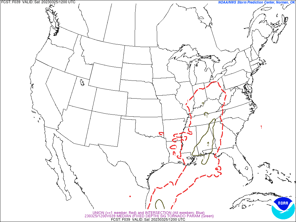
The significant tornado parameter does concern me a little bit, seeing values get up in the 2-4 range. Which again makes me think, even if this is "only" a squall line, the tornado threat definitely needs to be respected for storms embedded in that line. Like don't even assume all the damage would necessarily be on the weak end. Sometimes even a "quick spinup" can do fairly significant damage, especially if it hits a populated area.
But that is only one model. I'm going to take a look at the SREF now, the SPC's in-house model, because when the NAM starts to look a little scary, it is usually good to check it against the SREF.
Here are the STP values between 1 AM and 7 AM on Saturday. And you can see that overall, the values around here stay at about 1-2. That is your basic threat for isolated tornadoes. The only place around here that this model brings up to a 4 (like on the High-Res NAM) is around places like the Shoals down to Hamilton, Vernon, Sulligent, maybe down into Pickens County, also extending up to places like Waynesboro in Tennessee. So in or near those areas of Northwest Alabama, even the more laid-back SREF is saying, look out, you might have an enhanced threat of seeing some tornado damage tonight.


The instability does look marginal, even along and West of I-65. That is the big limiting factor for making this a tornado outbreak for our region, meaning North Alabama into Southern Middle Tennessee. Our friends back in Mississippi, Louisiana, and Arkansas will not have such weak instability, and I think Friday may be a rough day for them. I've even seen some chasers saying that it kind of makes them queasy looking at parameters for some of the areas there for where the worst weather is likely to get started.


The wind shear forecasts from the SREF are not as alarming as on the 4 km NAM, but still, any time you see 200-300 units or greater at only 1 km up in the atmosphere, you have to really be alert for a tornado threat, if there is even marginal instability to work with. And it looks like there will be, at least along and west of I-65. That is where the better potential for this severe weather will probably be, in our western counties. But all of us have some risk of it, tornado potential as well as damaging thunderstorm winds.


Here where the NAM is trying to simulate the radar, it is showing an initial broken line of storms between about 8 PM and 1 AM ahead of the main squall line. So again I wonder if some supercell potential will exist here. This is one of those setups where I feel like the mesoscale details could make a big difference in how it plays out, and the analog events have shown a wide variety. Most of them produced lower-end severe weather events, similar setups, at least for right here in our area. But a few produced a lot of damaging winds or several tornadoes, or even a more significant tornado or a few of them in our general area. So have been watching the trends closely.


And it is actually showing two more lines of storms coming through after that first one, not just one squall line for this event. And in between those lines, or any breaks in the lines, storms that form would need to be monitored to see if they are trying to become supercells. Those tend to do the most damage, and in an environment like this, carry a high threat of producing a tornado.
Even while I am allowing for the possibility that at least one or two spots in the Tennessee Valley might get a more significant storm like that, I'll also say that a lot of times when we get a messy/mixed storm mode like this, it tends to mitigate the severe weather threat some. Especially with marginal instability values. And especially when the timing of the best instability and best wind shear are a little out of sync with each other.
So I started to say that the current Storm Prediction Center was exactly on track, having a basic Level 2 out of 5 Risk for most of us, with an enhanced Level 3 out of 5 Risk for parts of Northwest Alabama up into Tennessee. But I have spent so much time on this post that I see the new Day One outlook is out, it is 1:01 AM. So let me take a look at that. And I guess that will be a good note to close on.


And man, this sure does look like a tornado outbreak setup for the Mississippi River Valley. If you know anybody in Mississippi, or around Memphis, back into much of Arkansas and Northern Louisiana, where you see that hatching for the tornado risk, might want to double-check and make sure they know this is going on tomorrow afternoon and evening. Or technically now it's Friday, but I mean Friday afternoon and evening. The threat for tornadoes there is fairly substantial, and some of these could be particularly damaging tornadoes that have a better chance of being a threat to life where they hit.
Even around here, with only a more routine 5% risk for isolated tornadoes, please take any warnings Friday night into Saturday morning seriously. Especially if it's a tornado warning, but also if it is a severe thunderstorm warning, I would not blow it off in an environment like this. It doesn't take a monster tornado (like chasers are hoping to catch in the Mississippi Valley from this event) to be a significant threat to life and property. So I would urge anyone reading to take the best precautions that are within your means, and encourage your loved ones to do the same, if you go under a warning during this event. After the watch comes out, I'd watch the weather and make sure you are close to your shelter, even before a warning may be required.
The main thing with this event is that not a lot of people stay up watching for bad weather on a Friday night. An awful lot of people are working, or have just gotten off work. With a lot of jobs, having all of Saturday off is a luxury. And for people fortunate enough to have a job with better hours for weekend plans, well, they want to relax at the end of a long week. They might want to do something fun. If they are awake at these late hours, they might be out having some drinks at a bar, or even sobering up at some place like a waffle house. They might be having a party at their home or with some friends and not have a clue until they see or hear something strange, and go: Oh wow, was it supposed to storm tonight? I'm not picking on my more tipsy readers either. Even excessively sober types can be totally unaware of these overnight severe weather threats. (Yes, that was an intentional play on words.) So the main thing is that this kind of weather can catch people off guard.
People think they should hear an outdoor siren. But that is really the wrong way to think about it. If you're outside, yes, or I guess if you live really close to one. But still, even living close to one, you are better off relying on a NOAA Weather Radio, or Wireless Emergency Alerts on your cell phone, or a radio or television station that will wake you up if you need to wake up. Some stations sound that really abrasive emergency alert tone that is almost impossible to sleep through, before they go into storm coverage. So even if you do not have a weather radio, maybe you could use that. But I think the big challenge for us with this event is that some people might just not know what's going on. I hope that WEA on cell phones makes it more likely that at least one person will see a tornado warning and decide to get people to a safe place and then gather more information. Those rarely go off for severe thunderstorm warnings though, even if they carry a "tornado possible" tag. They did on March 3rd because there was a "destructive winds" tag for winds of hurricane force expected within at least some of those severe thunderstorm warnings. But someone with only a phone for a source might miss out on a storm with 60-70 mph winds, that could knock a tree over on the house, or maybe break out a window or something. And once in a while, somebody gets hurt like that. So this doesn't look like a big outbreak for us, like it does for Mississippi. But it may not be what you'd call a low-end event either. I think the risk for severe thunderstorms and some tornadoes is respectable even around here. What will help us out with this event is if people know the risk is there, and plan ahead of time to have a safe place to go.
The National Weather Service in Birmingham has started a slogan, "Be the hero." So if you're the only person in your family or circle of friends who is aware of this, please consider spreading the word, at least to the people you know would care about it. Or if you are awake in the dark hours, and see someone in the path of a tornado, who might be asleep, then you might consider giving them a call or at least sending a text to make sure they know it is happening. I don't want to make this sound more dangerous than it is, the greatest tornado threat is well to our West, BUT . . . on the chance that someone you know does end up in the path of a really bad storm, especially if it's trying to produce a tornado, then you'll do them a big favor by just letting them know.
People do get cranky about getting a call at that hour, but they'll get over it. On the other hand, if they were to suffer some kind of serious or permanent injury because they were sleeping through a hit from a tornado or really powerful thunderstorm, that is not something where you can pull a Taylor Swift and say "shake it off" in a day or two. A lot of people have told me that they don't really care about storms because when it is their time to die, they are ready to die. But seriously, not everyone who gets hit by a tornado or severe thunderstorm wind event ends up dying from their injuries. And those injuries can be really rough. Again I'm not trying to scare anyone, but sometimes people have had to be in wheelchairs the rest of their lives because of injuries from a tornado. The vast majority of the time, these injuries are preventable with only the basic precautions. If you don't have an underground bunker or a bank vault-level safe room built into your home, that's all right, just get to the lowest and most central room, away from windows, and protect your body (especially head) the best you can against any falling or flying debris. About nine times out of ten, you'll survive even a direct hit from a tornado without any serious injury, usually without any injury at all.
One thing I will mention since I've already written an excessively long post, is that at night, some people might wake up and dash into their safe room or hallway in the house without time to put any shoes on. Please be careful, and maybe consider keeping your strongest pair of shoes (or if you've got boots, that's probably better, some of them have hard soles) in the safe place or by the bed or wherever you sleep. Because if you were to even get grazed by a tornado or a severe thunderstorm that damaged your home, there is likely to be broken glass. And there may be other stuff you would not want to step on. And sometimes people do because they are so shaken up by the stress of the moment that they do not feel any pain for a while. The main issue here is protecting people's lives, but we don't want people getting cut up either.
Absolutely would not stay in a mobile home for this event. I would try to spend the night at a friend's house that is anchored to the ground, or go to a public shelter well ahead of any storms, and just figure on staying there until the watch is cancelled out. I know it's inconvenient, but that's what I'd do. This stuff is dangerous even if our danger here is not as much as our neighbors back in Mississippi.
And as you can tell, I tend to go overboard with giving last-minute advice. Hope some of it helps instead of putting people to sleep.
You might notice the exact threat areas or timing forecasts do vary from one National Weather Service office to another, or they get adjusted a little even throughout the course of one day. But I think the basic message is clear that all of us in the Tennessee Valley have a risk for severe thunderstorms capable of producing damaging winds and a few tornadoes across the region. The severe weather threat is a little enhanced for Northwest Alabama up into Southern Middle (and actually also Central and West) Tennessee.
If you want to keep it simple for sheltering from a tornado:
* Be in a house or other strong building that is properly anchored to the ground, do not stay in a mobile home.
* Get to the lowest floor.
* Get in a small room like a bathroom, closet or hallway - staying well away from any windows.
* Try to make that room as near the center of the house as you can. Or if you are in something like a basement, just think of it as putting as many walls, or as much barrier, between you and that storm outside as possible.
* If you have time, get something to shield your body, especially your head, from any debris that might fall or go flying around in the air, if your house were to take a hit. The best is probably a safety helmet, like for football or riding a bike, but if all you have is a pillow or some blankets, use what you've got. Even getting up under a table or desk, if it's there, can be a good idea.
* Don't get caught driving through it either.
For severe thunderstorm warnings, you might not take quite as much precaution as for a tornado warning, but if you want to, that is probably ideal on a night like Friday night. It is sometimes hard to tell the difference unless radar gives some major clues that a tornado is there (like a debris signature). I definitely would not ignore severe thunderstorm warnings. At the minimum, I would stay away from windows in the house, and it's probably better if you are downstairs if there is more than one floor. I personally take the same precautions for a severe thunderstorm warning as for a tornado warning sometimes. But it depends on the situation. On March 3rd, I definitely treated it like a tornado warning. One time I totally ignored a severe thunderstorm warning and regretted it. Stuff started blowing at the windows in a hurry. No damage at my place that time except some smaller tree limbs down, but a few miles up the road, there was some significant damage, even to some structures. So I made a mistake there. Situations like this, I think "better safe than sorry" is a good attitude.
All right, wishing you all safety, and thanks for reading.


No comments:
Post a Comment