Boy these things can spin up fast.
3:25 AM - Ok things are getting busy.
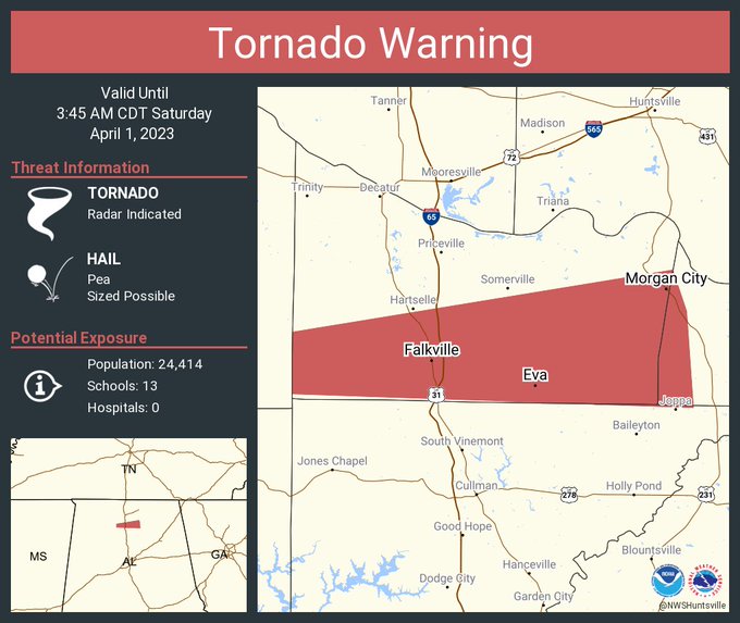
We have a Tornado Warning for Lincoln and Franklin Counties in Tennessee. That was a confirmed tornado. Also a tornado warning now including Falkville and Eva. A Severe Thunderstorm Warning that includes the city of Huntsville and another one that covers Northern Cullman County, places like Vinemont. Also some severe thunderstorms moving into Walker and Winston County.
Of course the Tornado Warnings are most dangerous, but
Wait a minute - another confirmed tornado in far Southern Walker County, just by the way - it's almost in Jefferson County looks like.
3:29 - Tornado sirens sounding in Cullman and I'm not sure why.
3:36 - Possible tornado should be to Arab and Morgan City in next ten minutes.
3:41 - Tornado warning remains in effect for Franklin County, TN mostly affecting rural areas, but remember this was confirmed earlier.
3:42 - New severe thunderstorm warning includes Scottsboro, and a tornado could develop quickly in this storm. Even if not, winds up to 70 miles per hour are dangerous enough.
3:44 - Okay, and now we have a Severe Thunderstorm Warning that extends down to Cullman and Good Hope, and also notes that a tornado is possible, could develop quickly within these severe thunderstorms in this part of the squall line. So if you are in Cullman, I would go ahead and go through your severe weather safety plan - small central room on lowest floor of a sturdy house (not a mobile home), and cover your head - just to be on the safe side. Ditto for people up around Scottsboro. Why take chances with these storms tonight?
4:04 AM - Internet was out for a few minutes. It is back on now. Will try to catch up quickly . . .
4:06 - It is still running very slowly on both Twitter and the radar application . . . trouble getting those to load . . .
4:30 AM - Using mobile data to maybe get net to work again...
4:32 - And the severe thunderstorms have moved into Marshall and Dekalb County, will probably clear North Alabama within about the next hour or so. Albertville and Fort Payne are in the path of potentially damaging winds though.
The Tornado Watch is being cancelled for the areas the squall line has already passed through. Internet is slow on mobile data but better than nothing. I did not lose power. Nobody I know had any power out or damage this go round.
4:37 - Wow, broadcast media reporting damage and two people hospitalized when the tornado hit Bear Creek earlier.
4:42 - And trees down near Arab.
Since internet is so slow anyway there is a good chance I will fall asleep before these storms completely clear Dekalb County and get into Georgia. So if anybody was following updates from there, sorry, but it's been a long day/night, and I have technical limitations going on.
Will try a forecast after some sleep. From what I remember, this weekend looks quite nice. Then an unsettlled pattern starts back on Monday. By Tuesday or more likely Wednesday, we may have more potential for strong storms. It's the time of year for it. It'll be muggy and some rain/thunderstorms Monday though Wednesday anyway, regardless of whether anything becomes severe.
Once the models can work with today's atmosphere behind the first storm system, I think the forecasts will be a lot clearer for this coming week.
528
WFUS54 KHUN 010820
TORHUN
ALC095-103-010845-
/O.NEW.KHUN.TO.W.0035.230401T0820Z-230401T0845Z/
BULLETIN - EAS ACTIVATION REQUESTED
Tornado Warning
National Weather Service Huntsville AL
320 AM CDT Sat Apr 1 2023
The National Weather Service in Huntsville Alabama has issued a
* Tornado Warning for...
West central Marshall County in northeastern Alabama...
Southern Morgan County in north central Alabama...
* Until 345 AM CDT.
* At 320 AM CDT, a severe thunderstorm capable of producing a tornado
was located near Falkville, or 8 miles southwest of Hartselle,
moving east at 55 mph.
HAZARD...Tornado.
SOURCE...Radar indicated rotation.
IMPACT...Flying debris will be dangerous to those caught without
shelter. Mobile homes will be damaged or destroyed.
Damage to roofs, windows, and vehicles will occur. Tree
damage is likely.
* This dangerous storm will be near...
Falkville around 325 AM CDT.
Arab and Morgan City around 345 AM CDT.
Other locations impacted by this tornadic thunderstorm include Eva,
Lacon, Ryan Crossroads, Florette, Massey, Hulaco, Cole Springs and
Somerville.
PRECAUTIONARY/PREPAREDNESS ACTIONS...
TAKE COVER NOW! Move to a basement or an interior room on the lowest
floor of a sturdy building. Avoid windows. If you are outdoors, in a
mobile home, or in a vehicle, move to the closest substantial shelter
and protect yourself from flying debris.
&&
LAT...LON 3432 8711 3441 8711 3450 8656 3444 8654
3430 8653
TIME...MOT...LOC 0820Z 264DEG 49KT 3433 8701
TORNADO...RADAR INDICATED
MAX HAIL SIZE...<.75 IN
$$
25


No comments:
Post a Comment