


11:17 PM - Let's take the wide view since there are no warnings in our vicinity at the moment.

For now, these storms are strong, capable of gusty winds, small hail, frequent cloud to ground lightning, and some pretty decent rainfall, but are under severe limits.

11:42 - The Tornado Watch has been cancelled for Lawrence and Wayne Counties in Tennessee, also for points West in Tennessee and much of North and Central Mississippi.
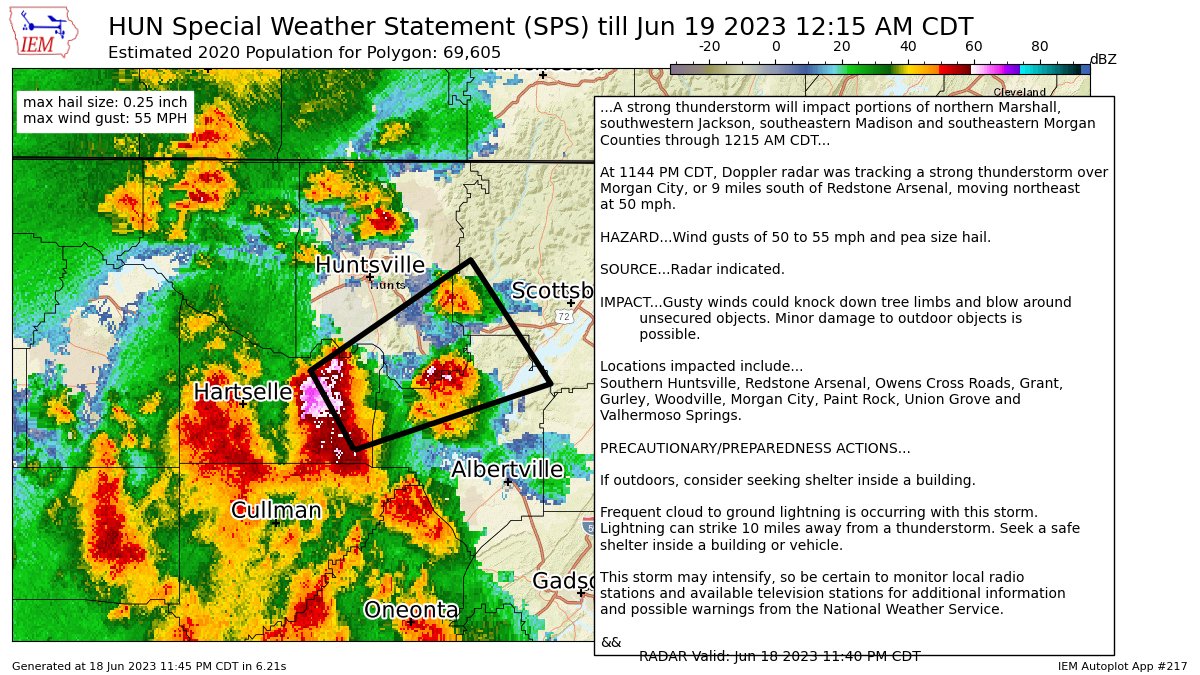
11:45 - Then this storm moving out of Morgan City toward Owens Crossroads and Southern Huntsville is just under severe criteria. If you want to seek shelter near the center of your home, lowest floor, away from windows, won't get a fight out of me on that one. It is a close call, and sometimes it is better to play it safe.

11:54 - Now this storm has been upgraded to a Severe Thunderstorm Warning as it moves into Southeast Madison, Southwest Jackson, and Northern Marshall Counties.
This actually does clip Southern Huntsville and Redstone Arsenal.


11:57 - For now the warning only mentions quarter-sized hail and 60 mph wind gusts. But the hail sure looks bad on radar, the VIL product. Would not be surprised if somebody gets worse hail than that, could damage a vehicle.
Hope nobody is driving through this. If I was driving and saw this coming, I'd try to pull over to the nearest gas station or any business that was open where I could get inside until this blew past.

12:02 AM Monday Juneteenth - This storm may still be producing 60 mph wind gusts but is confirmed to have golfball sized hail at Owens Cross Roads. Could do considerable damage to vehicles or injure people who are outdoors.
12:05 - Huntsville utilities is reporting power outages between Lacey Springs and New Hope. That could be from lightning or from damaging winds. If you are in the path of this storm, best to be in a sturdy house, away from windows on the lowest floor.

12:11 - That severe thunderstorm with large hail and some power outages is holding together as it moves into Jackson County around Paint Rock. There is a strong thunderstorm moving into Cullman with a lot of lightning and maybe some gusty winds, but for now, it looks like it is staying under severe limits.
12:15 - Ok now the hail is up to baseball size.

This is moving from Woodville up toward Hollywood and Skyline in Jackson County now.
If you have time I'd put the car in a garage or under a parking deck. But first and foremost, protect life, because there is also potential for damaging winds - these winds shook a law enforcement car earlier. And this size of hail blowing around in the winds can knock windows out of a house. So try to get into a small interior room on the lowest floor of a sturdy house.

12:18 - Ok conflicting information here. The Weather Service is saying hail is estimated down to quarter size. Broadcast media reported that baseball sized hail was reported at Woodville. I would play it on the safe side as far as the hail threat goes and respect the damaging wind threat anyway.
12:21 - National Weather Service in Huntsville now confirms that emergency management did report baseball sized hail in Woodville. Other reports have been more like half-dollar sized hail from same storm or even quarter-size. This is a dangerous storm either way. It is capable of that extra-large hail, which can damage vehicles and hurt people caught out in it. As a relative of mine used to joke, that'll knock a hole in your head.
Latest update from Weather Service in Huntsville says storm has a history of producing at least quarter size hail but allows for up to 1.5 inch diameter which is golfball sized.

12:24 - That storm back in Colbert and Franklin Counties is on the strong side, some strong wind gusts in it, but so far the only one at severe limits is the major hail producer in Jackson County. Remember it has also knocked out power, probably from winds, from some cops describing how it shook their vehicle as the storm went past.
12:29 - Broadcast media saying that Madison County Sheriff is reporting several instances of structural damage in Owens Crossroads from where this severe thunderstorm passed earlier.

12:31 - Within about the next ten minutes, I suspect this warning will be extended to the Northeast, as it is holding together well. The part of the storms moving into Dekalb County has not prompted a warning, just a special weather statement noting the storms are strong but under severe limits down that way.
Be alert for possible trees down after the hailstorm that just went through. Officers are on the scene of one tree down in the 400 block of Wilson Mann Rd. Now. @CamutoWHNT @NWSHuntsville pic.twitter.com/lphPfgkOnr
— StormChaserAndrew Baker 🌪️ (@ChaserBaker) June 19, 2023
12:40 - Looks like some trees down too from this storm. You don't want to drive up on one of those in the road tonight. Please be careful out there if you have to drive even if storms have already passed. Thanks to this storm chaser for the report.
12:43 - And great news now, the storm in Jackson County has weakened below severe limits, not thought to pose a threat to life and property in that way, so the warning is being allowed to expire on time.

So what we have now is just a mess of rain and thunderstorms that are all below severe limits here as we get close to one in the morning. We have to watch for about another hour in case of anything else getting out of hand somewhere, but for the most part, I think the atmosphere is worked over. If we see any more storms go severe, should be an isolated storm or two, doubt we even see that. But the Tornado Watch remains in effect until 2 AM. And we have to respect the potential even though the situation is borderline.
12:48 - Reports continue to make it sound like Owens Crossroads got hit pretty hard with that very large hail and wind damage.
10,000 people without power (likely due to lightning in Cullman Co.). Alabama Power reporting around 3,800 customers out as of 12:48 AM - many of those around the Birmingham area.
— Jason Simpson (@simpsonWVTM13) June 19, 2023
12:51 - But it sounds like reports of power outages other places too, including in Cullman County, thanks to Jason Simpson for keeping us posted on that.
357
WWUS84 KHUN 190409
SPSHUN
Special Weather Statement
National Weather Service Huntsville AL
1109 PM CDT Sun Jun 18 2023
ALZ007-008-016-190500-
Marshall AL-Morgan AL-Cullman AL-
1109 PM CDT Sun Jun 18 2023
...A strong thunderstorm will impact portions of west central
Marshall, northwestern Cullman and Morgan Counties through MIDNIGHT
CDT...
At 1108 PM CDT, Doppler radar was tracking a strong thunderstorm 7
miles northeast of Sardis, or 10 miles southwest of Hartselle, moving
northeast at 40 mph.
HAZARD...Winds in excess of 40 mph and pea size hail.
SOURCE...Radar indicated.
IMPACT...Gusty winds could knock down tree limbs and blow around
unsecured objects. Minor damage to outdoor objects is
possible.
Locations impacted include...
Hartselle, Falkville, Vinemont, Somerville, West Point, Eva,
Valhermoso Springs, Cole Springs, Battleground and Lacon.
PRECAUTIONARY/PREPAREDNESS ACTIONS...
If outdoors, consider seeking shelter inside a building.
Frequent cloud to ground lightning is occurring with this storm.
Lightning can strike 10 miles away from a thunderstorm. Seek a safe
shelter inside a building or vehicle.
This storm may intensify, so be certain to monitor local radio
stations and available television stations for additional information
and possible warnings from the National Weather Service.
A Tornado Watch remains in effect until 200 AM CDT for northwestern
Alabama.
&&
LAT...LON 3424 8711 3436 8711 3455 8678 3455 8675
3459 8671 3459 8669 3456 8667 3455 8665
3436 8647 3415 8706
TIME...MOT...LOC 0408Z 240DEG 34KT 3430 8703
MAX HAIL SIZE...0.25 IN
MAX WIND GUST...40 MPH
$$
25


No comments:
Post a Comment