Tuesday (High 90, Low 65): Sunny. Breezy.
Wednesday (High 93, Low 66): Partly to mostly sunny. Isolated thunderstorms are possible.
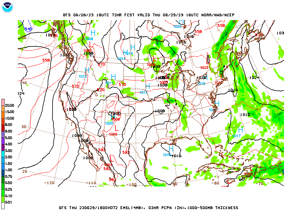
Thursday (High 98, Low 70): Mostly sunny, really hot and humid. An isolated thunderstorm is possible.
Friday (High 100, Low 73): Mostly sunny with a 20% chance of a thunderstorm.
Saturday (High 97, Low 73): Partly cloudy with a 20% chance of showers/thunderstorms.
Sunday (High 94, Low 74): Partly cloudy with a 30% chance of showers/thunderstorms.
Monday (High 92, Low 73): Partly cloudy with a 30% chance of showers/thunderstorms.
We started the day with some clouds left over in the Tennessee Valley today, but those gradually broke up and gave way to abundant sunshine in the afternoon. Winds were variable but most often from the West at about 5-10 miles per hour, with some periods it did get breezy with some higher gusts. Here at 9 PM we are at 73 degrees in Cullman under clear skies. The dewpoint is 70 degrees, making the relative humidity 89%. The winds have gone totally calm. And the pressure is 29.87 inches and rising slowly. That's 1011.5 millibars. Sadly I did not calculate that, but was simply frustrated that they don't give the Cullman observations in millibars, and decided to "Google" it. It would probably behoove me to calculate such things again on my own. Anyway our High today was 88 after a Low this morning of 66. Jasper saw a High of 90 and a Low of 64. And Haleyville got up to 88 after a Low of 67.


And what a difference a day can make as far as those radar and satellite images. The storms have moved into the Mid-Atlantic up into New England now, quite a few thunderbumpers apparent in the Carolinas and Virginias.
And some of those have been severe up that way. Lots of damaging wind reports.
Though we had even more severe reports in the Southeast up through the Ohio River Valley yesterday. A lot of ours down here were hailers, and there were a few reports of a tornado in Indiana, may have been more than one tornado. It can take a few days to sort such things out.
Locally we have
some damage from estimated 70 mile per hour winds in Fairview yesterday. The National Weather Service in Huntsville surveyed it along with the Cullman EMA and were not able to determine whether it was straight-line winds or a tornado. There was some rotation yesterday in East/Northeast Cullman County that prompted a Tornado Warning, fairly rare to see in the summer months unless we've got a hurricane coming inland. But it has been a wacky summer so far. Please learn from my bad example yesterday: I actually slept through that tornado warning. My weather radio already kept waking me up for so many Severe Thunderstorm Warnings nearby, where I wasn't exactly in the polygon, and I was as tired as I've been in a long time. It's only the second time in my life I remember sleeping through a tornado warning. Somehow I missed it, but noticed it was about to expire when I woke up for another Severe Thunderstorm Warning, the best I remember. That sort of thing can be dangerous, and I really should have gotten my sleeping done before the weather turned threatening. The only other time that's happened was when I lived in Arab, and a tornado warning came out in the wee hours of the morning. I woke up while the weather radio was still playing. Had one that voice-activated for five minutes. I don't think the newer models do that. I think this radio is the same one as I had then.


There is a strong Low pressure system up over the Great Lakes region, and there is a strong High pressure system centered over Texas and the Plains. For now we are in between those, with Northwest wind flow up at the upper levels of the atmosphere. Don't let that weak frontal boundary concern you too much. It will drop into South Alabama tonight and tomorrow and isn't really going to affect our weather much.
The pattern basically holds tomorrow, and we should see sunny skies, a High near 90, morning Low near 65. For the short-term, we have low humidity for this time of year, but that's not going to last long. We will probably get breezy at times tomorrow because of the overall pattern combined with that frontal boundary moving through.
Then we have to start paying attention to this odd trend the GFS has been showing, of another (smaller-scale) MCS coming down the pike in that Northwest flow on Wednesday.
The NAM has picked up on the idea too, though it gives it a track more to our West and passing to our South.
The ECMWF is not picking up on this idea. It sure would fit with this pattern this time of year though.
Only going to introduce a 20% chance of rain/thunderstorms. Most of us will probably stay dry, and maybe all of us will stay dry. This is just a low chance of having a cluster of strong thunderstorms at least clipping us in North Alabama. More likely it'll stay to our West/Southwest in its track. High should make it into the lower 90's, about 93-94, morning Low about 65-66 again.
Will keep that minimal chance of rain for just isolated random showers or storms on Thursday, but that "heat bubble" from Texas will start to move into our region. So if you do get any rain, you might be lucky. The High should be in the upper 90's, Low of about 70 or so.
Then on Friday that strong upper High will open out into more of a ridge. We'll still warm up to about 100 degrees, Low in the lower 70's. And we could see an isolated thunderstorm or two. Where storms do form in this kind of heat and humidity, they could briefly pack a punch, produce some strong winds or hail. A lot of times these are called "pulse" storms, typical summer thunderstorms.
It looks like some more moisture will drop in here on Saturday ahead of a front, but it looks more like later Saturday into Saturday night, so we should still see upper 90's for the High Saturday. Low should stay in lower 70's. rain chance staying at 20%.
Then that front should be trying to wash out in our region on Sunday. Think I will increase rain chance to 30% here and bring the High down to the lower-to-mid-90's, maybe about 94, Low in the lower 70's still.
Then a week from today, next Monday, looks like the remnants of that front will keep a 20% chance of rain in the forecast. Actually taking the ECMWF guidance into account too, will keep a 30% chance of rain, like Sunday, and trend High temperature more toward 90, Low more toward 70, so much more seasonable weather on the way next week.
Peeking beyond that, the model trends suggest July the 4th will feature scattered rain chances and again, more seasonable temperatures instead of the excessive heat expected late this week. And by Thursday of next week, the GFS wants to bring some sort of tropical system up through South Alabama from the Gulf of Mexico. But you can't put too much stock in rogue ideas like that, especially with the GFS. The ECMWF is not showing it, and usually these wild scenarios do not play out. They are just fun to notice if you're really into weather, and wonder if it'll be that one time out of ten there's something to it.
The National Weather Service offices in Tennessee have partnered with the Tennessee Emergency Management Agency to put together weather preparedness pages in
English and in
Spanish. Kudos to them for such efforts. Spanish is one of the easier languages to pick up on. English is actually a hard language unless you grow up with it.
The remnants of Tropical Storm Cindy are expected to pass over or near the Island of Bermuda on Thursday, and while it is not likely to regenerate, the Hurricane Center is keeping an eye on it.


No comments:
Post a Comment