

Monday (High 90, Low 67): Partly to mostly sunny. An isolated shower or thunderstorm is still possible, at least in the morning.
Tuesday (High 91, Low 66): Sunny. Low humidity.
Wednesday (High 93, Low 65): Mostly sunny. Hot but low humidity.
Thursday (High 98, Low 69): Mostly sunny.
Friday (High 100, Low 73): Partly to mostly sunny with a 20% chance of a thunderstorm.
Saturday (High 97, Low 74): Partly cloudy with a 20% chance of thunderstorms.
Sunday (High 94, Low 73): Partly cloudy with a 30% chance of showers/thunderstorms.
* Combination of heat and humidity will get into the danger zone in the extended part of this forecast, mainly Thursday through Saturday. *
Here at 10:46 PM we have a strong thunderstorm moving through Cullman, last reported wind gusts at Folsom Field were up to 21 miles per hour, so well below severe limits there. We did have several severe thunderstorms earlier today in North Alabama and up across the Tennessee border. Looks like they even had a tornado or two up in Indiana. Anyway we are at 75 degrees, same as dewpoint, 100% humidity. Visibility is down to 8 miles for now. Winds are Southwest sustained at 15 mph but as I said, some higher gusts from this thunderstorm. The pressure is 29.92 inches and falling.
Our High today got all the way up to 90 degrees after a morning Low of 64. The visibility is down to 5 miles in Jasper from their part of this cluster of thunderstorms. Winds have gusted up to 37 mph there. They saw a High of 91 and Low of 63. Visibility has gone down all the way to 2.5 miles in Haleyville, where their official wind gust got up to 28 mph with these late night storms. They had a High of 92 and Low of 66 today.

And I missed the main event today. I was tired from some other things, been working a job that actually paid something, and slept through the tornado warning that was issued including Holly Pond today. I did briefly wake up for some severe thunderstorm warnings around the same general time frame, but as soon as I heard they did not affect my location directly, snoozed again. Looks like in the Tennessee Valley today, we had numerous instances of hail anywhere from quarter to golfball size. And there were a few trees down here and there, mainly in Tennessee, but also noticed a report in Dekalb County of some trees blown down. The only injury I've heard of unfortunately proved to be a fatal one, when someone in Georgia had a tree fall on 'em outdoors.

So our severe weather threat tonight is over. And I'm just going to focus on posting a forecast. I really cannot do real-time severe weather updates on this blog like when I was in college, but in case I ever do get a chance to study meteorology again, aiming for a job in it, this blog is a way to keep my wits sharp. Forecasting the weather is challenging. Usually summer is the easier time of year. But this summer has been weird. I know I've done a lot of covering severe weather in real-time here in the past, but that's been because I was home, had the time, had the energy. It is not something I can commit to, especially since this is a self-imposed job that is never going to pay off. It is rare that I even get any feedback on the things I post, or a note from family who have been through a bad storm to let me know they're okay. So this is mostly wasted effort anyway. It is just something I find interesting to still try to do.
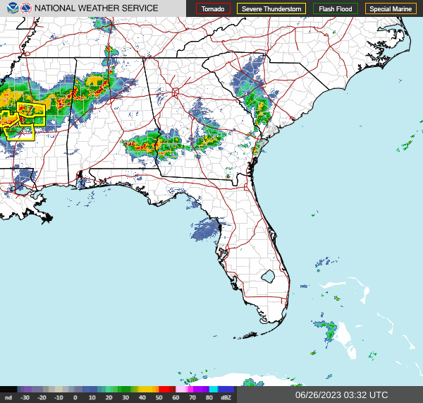


There sure was a lot of cloud-to-ground-lightning in the storms today, along with the severe stuff. The hail got worse around here than was forecast, but I think the damaging wind forecasts from the SPC were great.
Tomorrow I'm just going to make allowance for an isolated shower or storm to hang around in the morning, but I am starting to doubt we see even that. High should get up to about 90 again, and the Low in the morning should start out in upper 60's, about 67-68.
Then as high pressure moves in from out West, Tuesday should be a clear, sunny day, with the High staying about 90 or so, the Low dropping to about mid-60's in the morning due to a brief period of low humidity, good radiational cooling possible at night.
Wednesday looks similar, High in lower 90's, Low in mid-60's. One latest run of the GFS wants to bring rain chances back in here, but for now, think I will discount that since no agreement from other models, and overall the pattern has been showing that we'll dry out Tuesday and Wednesday at least.
And then bring on the heat wave for a few days. That heat bubble, strong upper-level High, that you can see already on the maps above over Texas, will start to shift further into our region.
Looks like we'll get into the upper 90's on Thursday, Low near 70. Technically you can have isolated rain or a thunderstorm any summer day in the heat and humidity, but chance is too low to put into a real forecast for now. It looks like the heat and humidity will get dangerous though, with heat indices up to 105 degrees or higher a good possibility as we get into the late week.
Then Friday looks like the hottest day, about 100 degrees without even factoring in the humidity for a heat index, that is the actual High temperature, expected to be about 100 degrees, with a Low in the lower 70's. Could see an isolated thunderstorm, but don't count on it. Main thing is to protect yourself, loved ones, even pets, from this seat. Absolutely do not leave anybody in a car on days like this. Really shouldn't do that anyway. "Beat the heat - check the back seat."
Again on Saturday will definitely have a 20% chance of a thunderstorm, and as the upper-level pattern relaxes a little, can bring temperatures back into upper 90's.
Then for Sunday, end of the forecast period, rain chance comes up to 30%, High should be more in the mid-90's, Low in lower 70's.
Some forecasters, at least in the broadcast world, are already speculating on the 4th of July. Not going to do that tonight except to say that beyond this next weekend, the models have trended temperatures more toward seasonal norms and that the pattern would favor more typical summer rain. Even saying that much, I hasten to add that this summer has been a strange one so far, and beyond seven days out, the weather could certainly throw us another curve.
Tropical Storms Bret and Cindy have both dissipated as expected.
And it isn't worth showing QPF this time of year in this dry of a pattern. I was showing it when we were having all that rain and storms and the pattern was anomalous. Excessive rainfall will not be a concern at all in the near future, but staying safe in the excessive heat will be, especially as we get toward this next weekend. Friday will probably be the worst.


No comments:
Post a Comment