(Forecast)
Sunday (High 94, Low 73): Partly cloudy, hot and humid. Widely scattered showers and thunderstorms are possible.
Monday (High 91, Low 70): Partly cloudy. Widely scattered showers and thunderstorms are possible.
Independence Day (High 89, Low 70): Partly cloudy. Scattered showers and thunderstorms are possible.
(Extended Outlook)
Wednesday (High 88, Low 69): Partly cloudy with a 40% chance of showers/thunderstorms.
Thursday (High 89, Low 68): Partly cloudy with a 30% chance of showers/thunderstorms.
Friday (High 90, Low 69): Partly cloudy with a 20% chance of showers/thunderstorms.
Saturday (High 90, Low 70): Partly cloudy with a 20% chance of showers/thunderstorms.
(Beach Forecast)
Sunday (High 93, Low 78): Mostly sunny, hot and humid. An isolated shower or thunderstorm is possible.
Monday (High 91, Low 76): Partly cloudy. Widely scattered showers and thunderstorms are possible.
Independence Day (High 91, Low 77): Partly cloudy. Scattered showers and thunderstorms are possible.
(Discussion)
It has been a mixture of hardcore summer heat and some summer storms in the Tennessee Valley today. We still have a severe thunderstorm pushing through Southern Walker County here after 6 PM. And you can see all the towering cumulonimbus clouds and lightning there on the satellite imagery.
And several storms have reached severe limits today in the region, producing mainly damage to trees and powerlines from thunderstorm winds. There was also a widespread power outage in Madison from a lightning strike. While lightning does not make a thunderstorm severe (only a certain level of winds or hail make it severe - 50 knots/1 inch diameter), severe thunderstorms often contain a lot of cloud-to-ground lightning, especially when there is plenty of unstable air to work with, like in the summer.
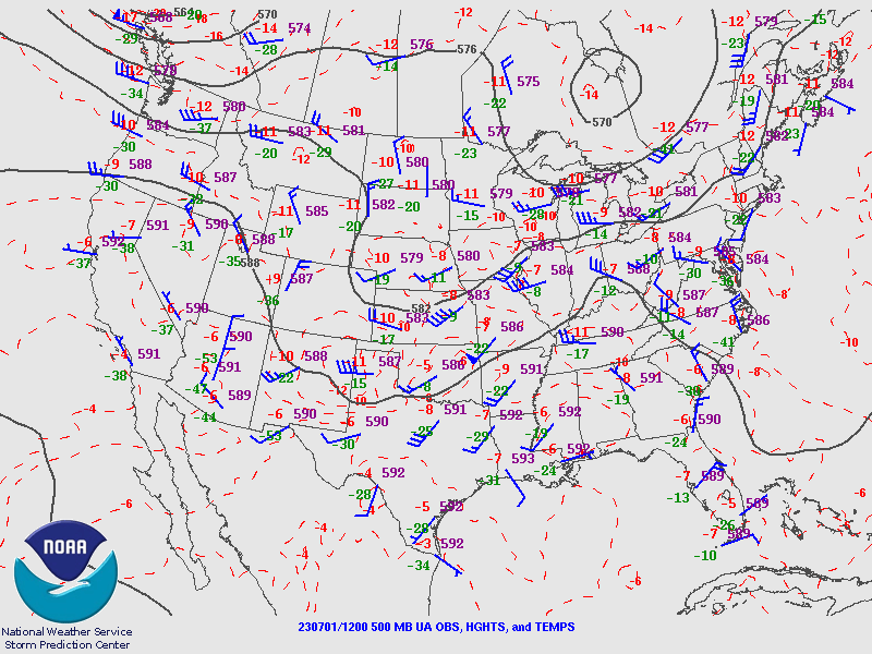
We are under a strong ridge of high pressure, which has brought us the heat lately. Winds follow lines of pressure on a weather map. And if you'll notice the isobars on the upper-air map, you can see why storms from the Midwest and the Ohio River Valley have made their way down here in this pattern.
This heat wave did not turn out to be as bad as it could have been though, partly because of the rain and storms tempering it, but also because of the good soil moisture we have left over from all the rain over about the past month when we were in that really weird pattern, that some said was more of an anomaly than in the past quarter-century.
Even though we had a severe thunderstorm in Cullman this afternoon, most of the day featured a good bit of sunshine before the rain came in. Our High ended up being 91, Heat Index at that hour was 107, and our morning Low was 72. So we still got pretty hot and muggy, just not as much as was in the forecasts. Without the humidity making the heat index so high, that's about normal for this time of year. In Jasper, the High was 95 with a Low of 73. And in Haleyville they also saw a High of 95 this afternoon, Low of 75 this morning.
Looking a little farther North, Fort Payne saw a High of 92 and Low of 66, not as muggy air up that way. Those parts of the state were under a Heat Advisory instead of the Excessive Heat Warning. Gadsden got up to 93 for the High after starting the day at 71. Decatur saw a High of 92 and Low of 69. Huntsville of course was in the path of some of those strong storms too and had a power outage from lightning in the county, Madison County, along with some strong winds. Their High was 93 with a Low of 71. Muscle Shoals had a High of 96 and Low of 71.
Elsewhere around the region, Fayetteville saw a High of 90 and a Low of 68. Nashville also saw a High of 90 after a morning Low of 69. Birmingham got up to 99 degrees, heat index of 108 at that hour, and that looks like our hot spot, the Low looks like 79 there, definitely looking at an urban heat island effect with that, is all I can think. Atlanta saw a High of 95 and Low of 73. Memphis saw a High of 96 and Low of 81. Man, this is some muggy air, more like you'd expect down around the beach. And Tupelo saw a High of 97, Low of 79.
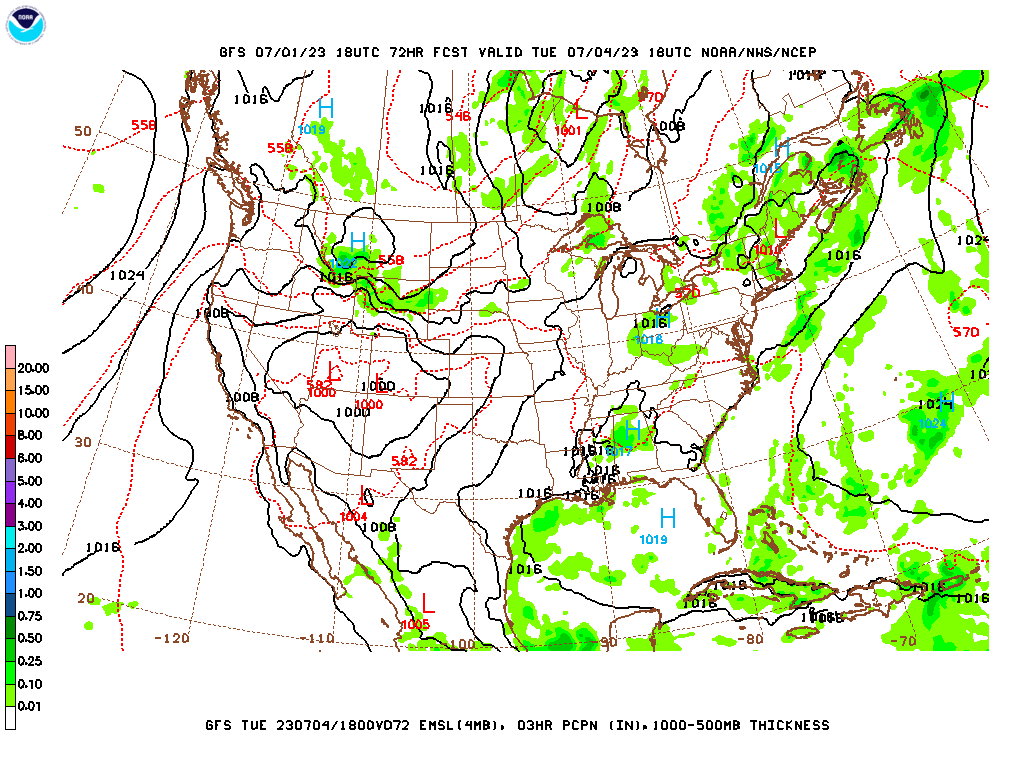
We're going to have a cold front dropping into the region soon and sort of riding the Alabama/Tennessee state line. And my guess is that it will stall out or wash out, maybe both, in that order. That tends to be what they do this time of year instead of passing through and cooling us down like in the Spring months.
Tomorrow starts the pattern change, with upper-level winds shifting back to a more West/Southwest direction. Going to forecast a High near 94, Low near 73, 30% chance of rain. I may be overdoing the High there, considering how things went today. But taking into account other temperatures nearby, if we hadn't gotten a strong/severe thunderstorm when we did, we could have gotten into the mid/upper 90's like some of the other places. That tends to be the random luck of the draw, and even if we do get another shower or storm tomorrow, could make 94 before then. It's a decent estimate.
Basically the same pattern on Monday.
I think the NAM and ECMWF are correct in showing more of a continued moisture supply than the GFS, just looking at the overall pattern.
So again a 30% chance of rain, High near 90, Low near 70, more seasonable weather.
Then Tuesday, as folks are swingin' on the Fourth of July, moisture levels increase enough to merit a 40% chance of rain. Again we'll have a High of about 89-90, Low near 70.
Looks like that frontal boundary will stay stalled. Wednesday looks like the rain chance stays about the same, similar temperatures. Basically the same for Thursday except feel okay taking rain chance back down to 30%. Then for Friday I'm going to favor the GFS over the ECMWF for this particular forecast and go with a 20% chance of rain instead of the deluge the European model wants to advertise. Upper 80's for High, upper 60's for Low. Holding rain chance at 20% for Saturday.
Not going to do a 10-Day-Outlook officially up top this time, but if you read this, then I'll mention that the models trend drier and hotter going into next week (not this coming week obviously, but the week after this forecast period), but then isolated rain chances come back on Tuesday, even though we've got a heat bubble showing up out West, strong upper-level High.
Tropical Cyclone Beatriz has dissipated into a remnant low.
And Tropical Storm Adrian is expected to dissipate over open water in the Eastern Pacific by about Monday.
Other than that, the tropics are quiet.
It is probably the least reliable season for rainfall estimate maps around here, since the showers and storms we get are so random, tend to pulse up and get heavy and then weaken right back down. But as a general rule, we should see an average of about 1-2 inches of rainfall for this forecast period.
Elon Musk is on one of his power trips, one that finally caused my amusement to run out, so it looks like I am totally off social media for the foreseeable future. And I don't know how much I'll keep up this blog, even. I do see that a lot of people stop by and read it, however they are finding it. Hardly ever get any feedback, and nobody has bought me a coffee to help fund it, but a surprising number of people do read it. So I may keep it up every now and then.
P.S. At 7:19 PM adding in a Beach Forecast. For those I just look at the NWS forecast for Gulf Shores, and only change it if I think something is off base. The local forecasts are my own, beach forecasts are more like the word I'm passing along. Probably nobody cares if I put a copy of the forecast in Spanish, but since it's a holiday weekend, not over yet, some might care about a beach forecast. I did modify this one a little, like they wanted a 50% chance of rain for 4th of July, and I went with 40%. Because I trust past experience and climatology over the models this time of year.


No comments:
Post a Comment