


All right, so here we go. We are getting these storms moving in during the peak heating hours of the day, which increases the chance of them becoming severe. This is an organized storm system, not the random kinds of summer storms you get just from the heat and humidity. Damaging winds are a good possibility, and actually, we may get isolated instances of very large hail, up to about the size of a ping pong ball. While the tornado threat is low, too low to merit a Tornado Watch, I'd still advise taking similar precautions if you get a warning today. Because the damage could be similar to what a quick spin-up tornado would do. We saw at the library the other day, you can occasionally have structural damage from straight-line winds in addition to trees or power lines coming down. A window blowing out of a house is a big deal. People can get seriously hurt or even killed if a few sensible precautions are not taken. A tree coming down on a home is a big deal, and you wouldn't want to be out in an open area where a lot of glass is breaking when that happened.
And look, I hope you, the reader, get no damage today. But we have to play it safe sometimes. I am prepared to take the Salem cat to the closet if need be, since there is a large tree outside my living room, and I had some very minor damage the other day. Didn't really hurt anything, just nerve-wracking since I had fallen asleep before the storm hit.
And that brings us to a very important point: The Cullman NOAA Weather Radio transmitter remains OFFLINE for now. That's Channel 3 on your weather radio. That's 162.45 megahertz. However, the Arab transmitter, Channel 6, operating on a frequency of 162.525 MHz, is back online. So people in Cullman County need to tune to that Arab transmitter today and tonight. This is important.
By the way, hats off and thanks to the people who restored the Arab transmitter to service. And the NWS Huntsville for passing along the information in a timely way.
Ideally today if you go under one of these warning polygons, you want to shelter in a sturdy house anchored to the ground (rather than a mobile home or a house propped up on blocks), in a small room or hallway (where walls are less likely to collapse, even if a tree or power line were to fall), sort of near the center of the structure, on the lowest floor. And of course you'll be away from any windows.
At minimum today if you go under a warning, you need to stay away from windows in your home and away from using anything electrical. Seriously, to keep up with the weather, I'd unplug your phone, pad, or laptop, and run it on battery power for a while. I had a close call with the electricity at my place the other day, even using a power strip. And today I'm taking a safety-first approach, even if some people might read it and think it's overkill.

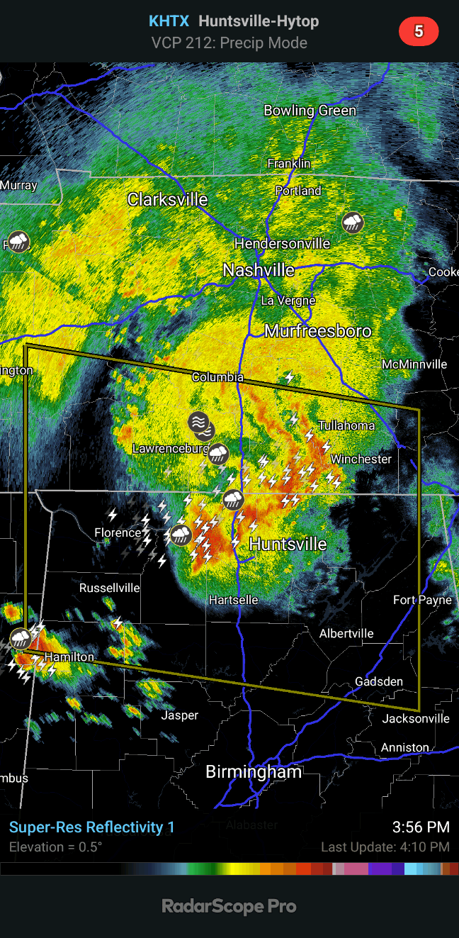
2:44 PM - As of right now, we have Severe Thunderstorm Warnings for Colbert and Lauderdale Counties in Northwest Alabama and on the Tennessee side, Wayne, and just now updated to include Lawrence and Giles Counties. The hail threat is not thought to be a big problem in these storms for now, like it would be with any more isolated storms that could hog the heat energy and humidity. But the winds may gust up to 70 miles per hour. The threat is said in the text of the latest warning to be considerable because of that damaging wind potential.

And you can see that does include cities like Florence, Tuscumbia, Muscle Shoals, up to Waynesboro and Lawrenceburg.
And you can see those spots where the colors come together in a contrast. It's not tight like you'd see for the rotation of a tornado, but it shows where winds are broadly blowing in opposite directions. And the bright colors also indicate strong winds that may be capable of damage. Anyway I would take these storms seriously, take the warnings seriously and get in a safe place until they have passed your location.
The other showers and storms on the radar for now are not severe.
2:51 - Afterthought: Pulaski, TN is also included in the warning up there.

2:54 - And now they've shifted the warning a little to the East, extending it to include places like Town Creek, Rogersville, and Lexington.

3:10 PM - The National Weather Service in Huntsville posted a reminder that even where the storms do not become severe, they are producing a lot of lightning today, really organized storms with a lot of lightning. And that is dangerous in itself. If you are close enough to see a flash of lightning or hear thunder, need to get inside, at least in a car if you can't get into a house or other building. And I wouldn't be around anything electrical in the house while storms with this much lightning are moving through.

3:20 - As the storms move toward Fayetteville, Lynchburg, Flintville in Tennessee, they are thought to be weakening below severe limits, with winds more around 40 mph.
3:22 - Actually I made a mistake in how I worded that. These are the storms out ahead of the severe ones.

But back behind those, is where we still have the storms thought to be producing damaging winds. Notice how even on the reflectivity we're seeing a good strong bow echo signature. That's where the winds are strong enough to make the rain sort of bow out forward over a large area. Whenever you see that, there is a good chance that some wind damage is happening down at the surface.
3:31 - Danielle Dozier is mentioning how the storm headed for Town Creek is showing some signs of trying to become a supercell.


And you can see some broad rotation there. It is trying to separate itself from the main line on the Southwest flank there. For now the concern is still damaging straight-line winds. But have to watch that trend in case it does try to go supercellular.
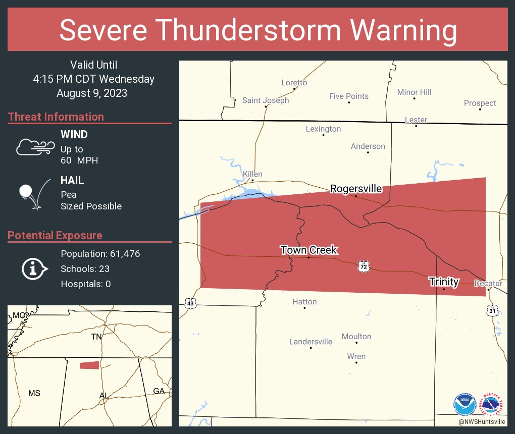
3:37 - People from Town Creek to Trinity to Rogersville, and Northern Lawrence County, need to stay sheltered as these storms move along.

3:39 - Also a new Severe Thunderstorm Warning for Lincoln and Moore Counties in Tennessee. Winds gusting up to 60-70 mph are a good possibility here. This is the cluster of storms where we've been seeing a bow echo. And then the one back around Town Creek is trying to rotate at times, trying to become a supercell. Either place, need to stay in a small central room or hallway on the lowest floor of a good sturdy house or other strong building until they pass.

Here's a radar update.

3:44 - Also watching this storm coming out of Mississippi crossing over into Marion County, Alabama, which is out by itself and could quickly become a supercell later.

3:51 - Besides the severe thunderstorms moving through Lawrence and Lincoln Counties, we are watching a couple of storms trying to get organized in Marion and Winston Counties, which are out by themselves in an unstable atmosphere with plenty of wind shear. If they strengthen, they could become supercell thunderstorms very quickly and prompt some warnings.
Storm damage right outside of the sorority dorms at the University of North Alabama in Florence. Photos from Avery Fuller pic.twitter.com/iBynwybnzk
— James Spann (@spann) August 9, 2023
And now we have confirmed damage from the campus of UNA from when these storms moved through Florence. So that's a reminder to take all these Severe Thunderstorm Warnings seriously the rest of this evening.
3:59 - We also have a flood warning in effect for rivers and streams in Colbert and Lauderdale Counties because of how much rain has fallen there.
4:11 PM - Good news for now. All storms have weakened below severe limits. We remain under a Severe Thunderstorm Watch until 8 PM. And we may see another round of storms closer to midnight tonight.


The severe thunderstorm warnings have been replaced by Special Weather Statements. So the storms are below severe limits. But could still produce winds of about 40 miles per hour and some small hail. There is still a lot of lightning in these storms too. This does include the city of Huntsville, having high winds but below severe levels.

4:32 PM - And now that storm around Hamilton and Bear Creek has gone severe.


4:34 - I would take this storm seriously, as it is showing signs of damaging winds and is taking on a supercell look at times. Get into a small central room or hallway on the lowest floor of a sturdy house, away from any windows.

4:41 - Also have a new flood warning in Limestone and Madison Counties for places like Huntsville, Brownsboro, Madison, and Triana. An off-duty NWS employee reported some flooding issues that could affect rivers and other small streams.

4:52 - That severe thunderstorm warning continues for about 35 more minutes for Northeastern Marion County. At times this storm is showing rotation, even a little bit of a notch, not quite a hook echo, but that rotation looks like it is strongest in the upper levels of the atmosphere, pretty weak and broad in the lower levels. So this thunderstorm could be called a supercell, but the winds it is producing are probably straight-line winds of about 60 miles per hour, also signs of quarter-sized hail in this storm. I'd still take it seriously and be in a small central room (bathroom, closet, hallway) on the lowest floor of a sturdy house.
5:02 PM - And we just got a special weather statement for places like Bremen, Colony, Garden City, and Hanceville in the southern parts of Cullman County. So I have started a new post for updates on the storms moving into Cullman County.
SEL7
URGENT - IMMEDIATE BROADCAST REQUESTED
Severe Thunderstorm Watch Number 617
NWS Storm Prediction Center Norman OK
150 PM CDT Wed Aug 9 2023
The NWS Storm Prediction Center has issued a
* Severe Thunderstorm Watch for portions of
Northern Alabama
Northeast Mississippi
Middle Tennessee
* Effective this Wednesday afternoon and evening from 150 PM
until 800 PM CDT.
* Primary threats include...
Scattered damaging wind gusts to 65 mph likely
Isolated large hail events to 1.5 inches in diameter possible
A tornado or two possible
SUMMARY...Storms are expected to increase and intensify along a warm
front/instability gradient across the region, with wind profiles
supportive of a few supercells and bowing segments.
The severe thunderstorm watch area is approximately along and 55
statute miles north and south of a line from 40 miles west northwest
of Muscle Shoals AL to 50 miles north northeast of Gadsden AL. For a
complete depiction of the watch see the associated watch outline
update (WOUS64 KWNS WOU7).
WOUS64 KWNS 091849
WOU7
BULLETIN - IMMEDIATE BROADCAST REQUESTED
SEVERE THUNDERSTORM WATCH OUTLINE UPDATE FOR WS 617
NWS STORM PREDICTION CENTER NORMAN OK
150 PM CDT WED AUG 9 2023
SEVERE THUNDERSTORM WATCH 617 IS IN EFFECT UNTIL 800 PM CDT
FOR THE FOLLOWING LOCATIONS
ALC009-033-043-049-059-071-077-079-083-089-093-095-103-133-
100100-
/O.NEW.KWNS.SV.A.0617.230809T1850Z-230810T0100Z/
AL
. ALABAMA COUNTIES INCLUDED ARE
BLOUNT COLBERT CULLMAN
DEKALB FRANKLIN JACKSON
LAUDERDALE LAWRENCE LIMESTONE
MADISON MARION MARSHALL
MORGAN WINSTON
MSC003-057-117-141-100100-
/O.NEW.KWNS.SV.A.0617.230809T1850Z-230810T0100Z/
MS
. MISSISSIPPI COUNTIES INCLUDED ARE
ALCORN ITAWAMBA PRENTISS
TISHOMINGO
TNC003-031-051-055-071-099-101-103-117-119-127-135-181-100100-
/O.NEW.KWNS.SV.A.0617.230809T1850Z-230810T0100Z/
TN
. TENNESSEE COUNTIES INCLUDED ARE
BEDFORD COFFEE FRANKLIN
GILES HARDIN LAWRENCE
LEWIS LINCOLN MARSHALL
MAURY MOORE PERRY
WAYNE
ATTN...WFO...BMX...OHX...HUN...MEG...
PRECAUTIONARY/PREPAREDNESS ACTIONS...
REMEMBER...A Severe Thunderstorm Watch means conditions are
favorable for severe thunderstorms in and close to the watch area.
Persons in these areas should be on the lookout for threatening
weather conditions and listen for later statements and possible
warnings. Severe thunderstorms can and occasionally do produce
tornadoes.
&&
AVIATION...A few severe thunderstorms with hail surface and aloft to
1.5 inches. Extreme turbulence and surface wind gusts to 55 knots. A
few cumulonimbi with maximum tops to 550. Mean storm motion vector
28025.
...Guyer


No comments:
Post a Comment