FORECAST:
Today (High 75): Isolated showers possible, mainly this morning. Cloudy, warm, and windy.
Wednesday (High 69, Low 61): Rainy and windy. Temperatures dropping rapidly behind the cold front.
Thursday (High 53, Low 30): Partly to mostly cloudy and turning cold again. Still somewhat breezy, especially in the morning.
EXTENDED OUTLOOK:
Friday (High 56, Low 40): Showers likely.
Saturday (High 67, Low 49): Partly to mostly cloudy with a 30% chance of showers/thunderstorms.
Sunday (High 72, Low 55): Partly cloudy with a 20% chance of a shower or thunderstorm.
Monday (High 70, Low 60): Rain and thunderstorms likely.
NOTES:
A Wind Advisory is in effect for all counties of North Alabama and Southern Middle Tennessee.
This is Severe Weather Awareness Week in Tennessee. I got confused earlier this month, thinking that Alabama and Tennessee were still coordinated on at least the timing, if not the approach of having a different topic for each day. I like the way Tennessee does it better now, continuing the old tradition of discussing a new topic for each day of the week. Today's topic is lightning. Yesterday's topic was flood safety, and Sunday's was the SKYWARN program.
On that note, the National Weather Service in Birmingham is doing SKYWARN classes starting this week, most of them online. If you want to prepare for this severe weather season we have in the Spring months, taking one of these free classes is one of the best ways you can do it.
With Spring Break coming up soon, even though I think different schools have different schedules for it, it is a good time to review how to stay safe in a rip current.
DISCUSSION:
Since sleep has been elusive this night, doing a weather forecast before the break of dawn.
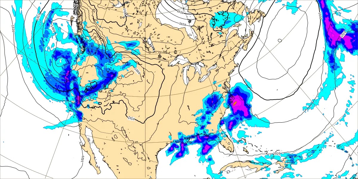
At 4 AM, it is overcast in Cullman. The temperature is 61 degrees. The dewpoint is 57 degrees, making the relative humidity 88%. Winds are out of the South at 15 miles per hour, with higher gusts to 24 mph. The pressure is 29.84 inches and falling.
Skies are also overcast in Jasper. The temperature is 63 degrees. The dewpoint is 61, making the relative humidity 94%. Winds are variable at 3 miles per hour. The pressure is 29.85 inches and holding fairly steady, but has been falling slowly over the last several hours.
It is mostly cloudy in Haleyville. The temperature is 61 degrees. The dewpoint is 58, making the relative humidity 90%. Winds are from the South at 14 mph. The pressure is 29.83 inches/1008.7 millibars and falling slowly.
Decatur is partly cloudy and 62 degrees. Huntsville has light rain and 62. Fort Payne has fair skies and 60 degrees. Muscle Shoals is mostly clear and 65. Tupelo is mostly clear and 64. Memphis is overcast and 66, wind gusting all the way to 36 miles per hour there, from the Southwest. I believe they are included in the Wind Advisory up there. Nashville is overcast and 64.
And actually they have extended the wind advisory down into North and Central Alabama now.
We have zonal wind flow aloft, and we actually have scattered showers and thunderstorms moving through the region this morning. For the most part though, today should be dry, the main chance for rain coming tomorrow.
If we see showers later today or tonight, they should stay isolated. Overall just a windy, mostly cloudy day, with the High temperature getting up to about 75, the warmest we've been so far this year.
Tomorrow that front comes in, and we'll stay windy with rain likely, can't rule out an isolated thunderstorm.
But this front is a fast mover, and it is beginning to look like this will be a day that our temperatures will be going backwards. It is challenging to put a proper High/Low temperature into a forecast for a day like this, but I'll summarize it as a High in about the 67-69 range and a Low near 60.
Thursday offers a brief break from the rain, the High in about the 52-54 range, the Low near 30, so at or below freezing again Thursday morning. And it'll still be breezy Wednesday night, maybe lasting into Thursday morning. Winds will be more from the North/Northeast. Probably more clouds than sun overall, but we could see the sun peek out at times.
The GFS model is now on board with the ECMWF's earlier idea of moisture surging back up in here from the Gulf on Friday. Rain chances keep trending upwards, and I'm just going to say that rain showers are likely Friday. High should be in about the mid-50's, the Low rebounding to near 40.
Then on Saturday the GFS shows rapid clearing.
While the ECMWF shows more showers.
The GEM look is closer to the European.
So will keep rain chances for Saturday and mostly cloudy skies, but rain chances on the lower end, about 30%, or about a 1-in-3 chance at any one spot getting a shower or thunderstorm. The High should be back in the upper 60's by this time, and the Low should be back up near 50.
The GFS shows us mostly clear on Sunday.
The European model wants to keep more showers around.
And the Canadian solution doesn't show as much moisture hanging around as the European, shows more of a clearing trend throughout the day.
So we'll keep a rain chance in there for Sunday but also keep it minimal, 20%, a 1-in-5 chance at a shower or thunderstorm. The High should get up to 70 or so, the Low in the mid-50's.
Then for Monday, even though the exact timing of this next front remains to be seen, confident enough to say that rain and thunderstorms are likely. High near 70, Low in upper 50's or perhaps even up to 60 for some places.
At this point, neither of these systems, the one tomorrow (Wednesday) or the one next Monday, carry a severe weather risk for our region.
The only area expected to get a decent combination of instability and wind shear with this system tomorrow is in Eastern Kentucky into West Virginia, the risk clipping Southern Ohio. And even there, the risk is marginal, very low.
Today the risk for severe thunderstorms could get a little more organized up in the Ohio Valley and up around the Great Lakes.
The unstable air looks too limited with both systems, although the one on Monday is worth keeping an eye on, especially given the time of year.
Based on the model trends right now, it looks like if we did see a severe weather threat Monday, it would be on the low end. And it is more likely that we won't see one. This is up along the AL/TN state line Monday afternoon, where the GFS thinks the best combination of unstable air and wind shear will come together. And at the moment, it isn't looking like much. Always good to be cautious this time of year, but this is probably just another rainmaker for the most part.
Rainfall amounts could average 2-3 inches for this forecast period, taking into account several chances for rain.
Just to be clear, some time between midday Wednesday and daybreak Thursday, temperatures are just going to plummet when that cold front comes through. We'll go from the 60's down to about 30 degrees in that time window. Combined with the winds, it will feel like a brutally cold night/morning. And depending on the exact timing of the front, some of us could be shivering while it is still midday or afternoon. For the official forecast, I put the morning temperature for the Low and for the High, how warm it'll get ahead of the cold front. Maybe in the future, will work out a better way to handle forecasting such days. But it may be one of those days where if you wanted to get technical, the High would happen while it's still morning, and the Low would really happen just before midnight, however cold it gets. And my guess is that we'll be to about the mid-30's by Midnight. Some of us may see upper 20's for Thursday morning's Low.


No comments:
Post a Comment