

FORECAST:
Sunday (High 67, Low 30): Sunny. Cold morning, mild afternoon.
Monday (High 71, Low 46): Mostly sunny. Warmer.
Tuesday (High 75, Low 58): Partly to mostly cloudy with an isolated shower or thunderstorm possible. Warm and breezy.
EXTENDED OUTLOOK:
Wednesday (High 72, Low 63): Thunderstorms likely - a few could become severe.
Thursday (High 54, Low 35): Mostly sunny with a 20% chance of a shower.
Friday (High 56, Low 39): Partly to mostly cloudy with a 40% chance of showers.
Saturday (High 61, Low 44): Partly to mostly cloudy with a 30% chance of showers.
PRONÓSTICO:
Domingo (Máxima 67, Mínima 30): Soleado. Mañana fría, tarde templada.
Lunes (Máxima 71, Mínima 46): Mayormente soleado. Más cálido.
Martes (Máxima 75, Mínima 58): Parcialmente a mayormente nublado con posible lluvia o tormenta aislada. Cálido y ventoso.
PERSPECTIVA EXTENDIDA:
Miércoles (Máxima 72, Mínima 63): Es probable que haya tormentas eléctricas; algunas podrían volverse severas.
Jueves (Máxima 54, Mínima 35): Mayormente soleado con un 20 % de probabilidad de lluvia.
Viernes (Máxima 56, Mínima 39): Parcialmente a mayormente nublado con un 40 % de probabilidad de lluvias.
NOTES:
The National Weather Service in Birmingham is doing SKYWARN classes for the Spring severe weather season. The National Weather Service office in Nashville is keeping it simpler and doing Weather Safety Basics classes. They've had some rough events in or around Nashville the past few years, so I'm glad they are trying to educate people more about first things first.
And one of the places you can hear good weather forecasts in North Alabama, 101.5 FM WJLX, is back on the air thanks to some help from iHeart radio in New York. Nonetheless, I see that their raising funds to replace their stolen tower and transmitter has stalled out at about a third of what they need. So if you would like to drop a dollar in their bucket or offer some encouraging words, here is the link again. Happy to say that a local Cullman station, Live 95.5 FM, was one of this other station's strongest supporters when all this first went down.
At 2 PM skies are sunny in the Tennessee Valley with a Northwest breeze.
It is sunny and 59 degrees in Cullman, with a dewpoint of 30, making the relative humidity 34%. Winds are from the Northwest at 20 miles per hour, with higher gusts up to 29 mph. The pressure is 29.98 inches and steady. This morning's Low was 41. Our High so far today was 61, and we've dropped to 59 again for now.
Jasper is sunny and 66 degrees at this hour. The dewpoint is 30 degrees, making the relative humidity 26%. Winds are Northwest at 15 miles per hour with higher gusts to 25 mph. The pressure is 29.97 inches and falling slowly.
Haleyville also has sunny skies and 60 degrees. The dewpoint is 31, making the relative humidity 33%. Winds are North at 12 mph with higher gusts up to 20 mph. The pressure is 30.02 inches/1015.7 millibars and rising slowly.
Gadsden is sunny and 63 degrees, quite a Westerly breeze. A Northwest breeze in Fort Payne, partly cloudy skies and 59 degrees. Similar conditions nearby in Scottsboro. Chattanooga also has the Northwest breeze, fair skies and 54 degrees up there across the TN state line. Sunny skies and 52 degrees in Winchester with the breeze out of the North. Huntsville is mostly sunny and 60 degrees, a good Northwest breeze. Decatur is sunny, breezy, and 61 degrees. Fayetteville is mostly sunny and 55, breezy just like everybody else today. Muscle Shoals is sunny and 60. Savannah is sunny and 55, Northwest winds at 13 mph, which is tame by today's baselines.
Elsewhere around the region, Atlanta is mostly sunny and 64 degrees, got Northwest winds at 23 mph gusting to 38 mph. Hang on to your hair over there, although it might be hard to notice the difference from the jetstream created by the usual traffic in that city. Birmingham is sunny and 66, West winds at 23 mph gusting to 35. Again, that's windy, but some places, people are kind of used to it because of the cars whizzing by and zipping across lanes and stuff. Tuscaloosa is sunny and 68 degrees, Northwest winds at 18 mph gusting to 31 mph. Tupelo is at 65 degrees, similar breeziness, skies sunny. Corinth is sunny and 57 degrees and wow, their winds are reported as sustained from the Northwest at only a solid 15 mph. Then the gusty winds resume as we look to Memphis, Northwest at 12, gusting up to 23 mph. Skies are mostly sunny there with a temperature of 55 degrees. And finally, Nashville, the Music City, which had a wonderful Severe Weather Awareness Day today, bringing together broadcast and operational meteorologists in an event free to the public, is partly cloudy and 49 degrees at this hour, its winds from the North at 12 mph with higher gusts up to 24 miles per hour. So they are not as full of hot air today as some of the bigger cities around our region. Actually none of them are full of hot air today, just warmer than we're used to seeing in a while, if you want to get technical . . .


Yesterday we had a few more showers than expected, later in the day. I had Salem venturing out on the porch when a girl in the neighborhood ran up, yelled my name, and informed me that it was raining. She proceeded to pet Salem, who eyed her very warily but allowed it. Then she decided she didn't want to be out in the sprinkling rain and ran on home. I have discovered that this cat does not like 9 Lives canned food. I think it was some sort of seafood blend he turned his nose up at yesterday. I was going to give him a preview of weekend treats. He'll get his usual Sheba wet food for this weekend though.
But not to get sidetracked from the weather, sometimes these upper-level troughs reveal themselves to also constitute surface boundaries, like say, a reinforcing cold front.
And that extra shot of cold air is going to bring us all the way down to about 30 degrees tonight/tomorrow morning. A few places could even dip into the upper 20's.


Even when high pressure is the main weather player over our region, like the next couple days, we can still have weak frontal boundaries that cause a change in temperatures. It sure is going to warm up quickly this coming week, even before we see any more rain.


Tomorrow is pretty straightforward. Winds will be light but shift back around to the West and then Southwest later in the day. So we will begin the day around 30 degrees and then under sunny skies, warm to probably the upper 60's, about 66-67.


We will warm up more on Monday as that high pressure system moves further to the East and the winds remain favorable. Skies will stay mostly sunny, but we'll see enough moisture return for a few clouds, and the Low will rebound quickly to about the 46-48 range, while the High should be about 70-72.


Then even more warm, moist air coming back in the region Tuesday, with clouds increasing. Those southerly winds will really be picking up too. By the evening, we'll probably see more clouds than sunshine. The GFS shows enough moisture for a few showers during the day in Southern Middle Tennessee.

While the NAM keeps us all basically dry, with a look that suggests an isolated shower or thunderstorm could happen anywhere in the region, but one of those dicey setups where you wonder whether it'd even be a 20% chance, enough to put in a forecast.

I'm glad I took a lot at the European though, because it shows rain chances at Noon on Tuesday. And it is more reliable in this scenario than the NAM usually. As a mesoscale model, the NAM starts to lose its precision at 72 hours and beyond.
So Tuesday looks partly to mostly cloudy and breezy, a High near 75, Low in the upper 50's, and a 20% chance of rain or a thunderstorm.


Then Wednesday, that next cold front is coming in. Here is the GFS look.


And just for contrast, here is how it looks bringing the front and probably a squall line of thunderstorms through the region from 6 PM to Midnight.


Then from Noon to Midnight, the ECMWF is showing a slower progression. That's why you have to be careful about these global models, they flip-flop so much. Yesterday we had a time period that the GFS was the one showing a slower timing.

However you slice it, we have a cold front coming through here on Wednesday, likely to bring us rain and thunderstorms.
How stormy it gets and where is another question to be considered below the main forecast discussion.


The GFS is back to showing clearing and high pressure moving in for Thursday, and since we have good agreement from the ECMWF, going to roll with it for now. It is now looking like Thursday will be a mostly sunny day with a High in the lower 50's and a Low dropping back into the mid-30's.


And the GFS keeps us dry on Friday on this run.

But the European brings moisture surging northward again. For now, going to lean toward this, since it makes sense for us to get about a day's break in the rain on Thursday, with this pattern.
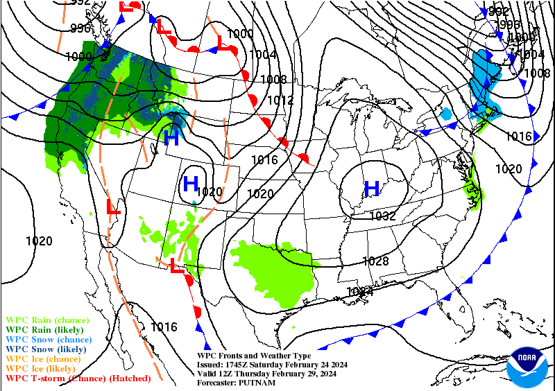


The Weather Prediction Center maps make it a little clearer than the model madness from Thursday through Saturday. So Thursday, mostly sunny, minimal chance of any rain lingering, High in lower 50's, Low in mid-30's.
Then Friday we'll bring back a 30% chance of rain, widely scattered rain in the region. High should be in the mid-50's, Low in upper 30's.
And then maintain that for Saturday, with the High closer to 60 or so, the Low rebounding into the 40's.
Actually considering a 40% chance of rain for Saturday but the situation is unclear. Could include a 20% chance on Thursday to account for the unsettled nature of this.
Taking another look at the ECMWF guidance, I think the best shot at doing good probabilities in the extended is 20% for Thursday, 40% for Friday, and 30% for Saturday. Latter part of the week looking unsettled.


It's still four days out, but the GFS trying to simulate the radar for Wednesday makes this look like a squall line coming through during the day.


It does look like we will have marginally unstable air available by 3 PM Wednesday, and enough wind shear to support a threat for damaging winds and large hail, maybe even an isolated tornado. This forecast sounding was taken from down around Smith Lake, on the Cullman/Walker/Winston county lines.
This system still is not within the range of the SREF or the NAM yet.


The Storm Prediction Center maintains that basic 15% risk of severe thunderstorms for basically the Midwest into the Ohio Valley for Tuesday, and then moves it further down into the Ohio and Tennessee Valley for Wednesday.


As they discussed yesterday, they've trimmed back these areas and refined better where the severe thunderstorms are a potential. For Wednesday, this includes most of the states of Tennessee and Kentucky and about the Northern thirds of Mississippi and Alabama.

So yes, that means us, but the threat areas will need to be refined over the next couple days and then as the event gets underway. Most of the model trends are making it look like the threat for North Alabama will be on the lower end, and actually, things are not looking terribly threatening for even Middle Tennessee. It is just one of those things to keep an eye on. We have a lot of them in the Spring months around here, many of which look more organized than this one is looking to be so far.
One thing I did notice is that the trough is expected to take on a negative tilt, which wasn't the case several days ago with what the global models were showing. So while the severe thunderstorm potential on Wednesday may end up being on the lower end from Middle Tennessee down to North Alabama, it is still worth keeping an eye on.
If you need a refresher course on weather safety, I would strongly encourage you to take the Weather Safety Basics class from NWS Nashville (link is above in "notes" section, to sign up) this Monday evening at 6:30 PM.
If that doesn't work out with your schedule, here is a thumbnail review.
Have a reliable way to get warnings, at least WEA on a cell phone, but preferably a NOAA Weather Radio with battery backup, and maybe an extra layer with a phone service like WeatherCall if it is within your budget.
If you go under a Severe Thunderstorm Warning or Tornado Warning, you need to be in a sturdy house or other building that is anchored to the ground and not stay in a mobile home. Try to plan ahead for this.
The basic idea is to get as low down in the structure as you can, and as near the center as you can, putting as much barrier as possible between you and the storm outside.
Usually a bathroom, closet, or hallway is the best place to be.
If it is a storm that may be producing a tornado, then it is important to get up under something sturdy or to grab something to shield your body, especially your head, in case any debris were to fall or go flying around in the winds. This can be simple, like getting up under a desk or set of stairs, or grabbing a pillow or some blankets. It can also be as hardcore as wearing a safety helmet like you would for riding a motorcycle or playing football. Most serious injuries in severe weather affect the head and neck.
Hope that helps, but I will refer you to the people taking the time and trouble to put on these classes for more information. Or here are the basics from the government guidelines for severe thunderstorms and tornadoes.
It really doesn't look like this Wednesday is likely to be that big a deal for most of us. But any severe weather threat should be respected. And we'll see if parameters change between now and then. The center of low pressure is still expected to pass far North and East of where you'd expect it to be for a really organized severe weather event. But like I say, I do believe in respecting even the lower-end severe weather potential days.
Looking at some analog events, I agree with the current SPC outlook. Best thing for now is to outline a broad area for a routine risk of severe thunderstorms and then adjust as needed as more data becomes available closer to the event.

Most of us will see an average of about a half-inch of rain for this forecast period, although isolated spots in North Alabama might see closer to one inch, and the chance of that might be a little higher for Southern Middle Tennessee.
By the way, you can still buy severe weather preparedness supplies tax-free tomorrow. This was our weekend for that. That includes batteries for a weather radio.


No comments:
Post a Comment