This is a squall line with stuff trying to develop south of it but mainly along the leading edge, storms becoming severe.
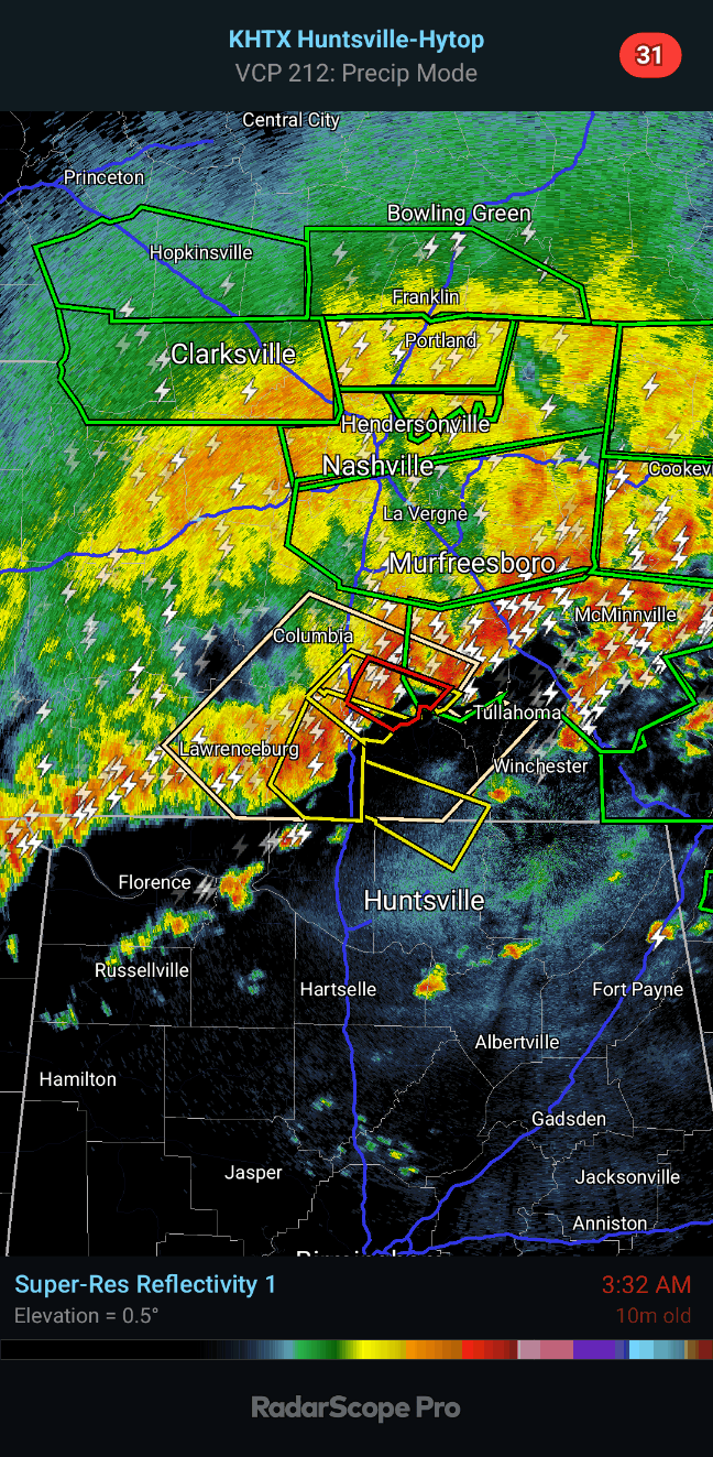
Severe thunderstorm warning for Lawrence County, Giles County, Marshall, Maury, Bedford.
Also a Tornado Warning for Bedford and Marshall Counties.
These go until 3:45 AM.
3:43 AM - Now a Severe Thunderstorm Warning with some weak rotation showing up in it, for Lincoln and Madison Counties, moving toward Ardmore, ready to cross the state line into Alabama. This new warning goes until 4:30.
These storms are not moving slowly like some of them were earlier, moving at about 55-60 mph.
If you go under one of these warnings, best thing to do is move to a small central room or hallway on the lowest floor of a sturdy house, away from windows.
3:47 - We're down to just the one warning, for Lincoln and Madison Counties. Some trees have been reported down back in Maury County with this line. Got that from broadcast media.
3:54 - Some of these storms are quite strong but under severe limits, which you see in the tan boxes, one headed for Huntsville, another aiming at Sylvania. And these are expected to have wind gusts up to 50 mph and hail up to penny sized for now.
These storms sure do have a preferred track with this system. These are the same areas that had tornado damage from last night, or I guess this has been one long night. My weather radio did wake me up for the Tornado Watch though. I caught an hour or two of sleep first.
4:18 AM - New warning for Flintville and Hazel Green over to Hytop.
Penny sized hail expected with it and wind gusts to 60 mph. Some weak rotation, a tornado could develop quickly in a storm like this part of the squall line.
4:30 - Got a possible tornado near Dunlap, TN and a severe thunderstorm capable of 70 mph winds and half dollar sized hail moving toward Chattanooga.
4:44 - And the severe thunderstorm warning extended farther into Jackson County. With 60 mph gusts and quarter sized hail expected. A note that a tornado could quickly spin up.
It occurs to me that this storm is headed for areas that were hit overnight by other storms, some of these areas hit by what looked like a significant tornado. So if you know anybody in the path, see if you can call or text them and let them know storms are coming. I don't know how many people are without power and where. I know they restored a lot of customers in Huntsville in these wee hours.
The tan colored boxes you see are Special Weather Statements, where thunderstorms are strong but below severe limits.
4:50 - Severe thunderstorm warnings even being extended into Northwest Georgia ahead of the line, 60 mph winds and quarter sized hail possible, also a note that a tornado could quickly spin up.
5:13 AM - Most the line staying under severe limits but still a Severe Thunderstorm Warning for Jackson County.
5:21 - Severe thunderstorm warning extended into Northern Dekalb County now.
5:25 - Hope people know this is coming, these are the same communities with damage from storms earlier in night.
5:34 - The severe part of this squall line is in Northeast Alabama/Northwest Georgia for now. Some weak rotation near Valley Head, a little notch trying to form on reflectivity there.
5:38 - Overall the other storms in the line are staying below severe limits for now. But they bear watching. The squall line has cleared out of Tennessee counties for the most part.
People around Mentone, be in a good safe place.
Also down in Cherokee County.
5:44 - Not worried about any more severe weather this morning for Southern Middle Tennessee. Tornado Watch has been cleared for them. Watching things carefully in North Alabama as the squall line sags southward.
5:46 - Now Cherokee County is our only warning nearby. The rest has crossed the Georgia line.
5:52 - We might have another round this evening or tonight - Thursday evening or Thursday night - but I'm not sure if the airmass can recover enough for that. But at least for most of the day after the squall line clears you, then your severe weather threat is over.
6:03 AM - The only warning is for Cherokee County. Blount and Etowah Counties are under a Special Weather Statement and could see wind gusts up to 50 mph and small hail in the line of storms.
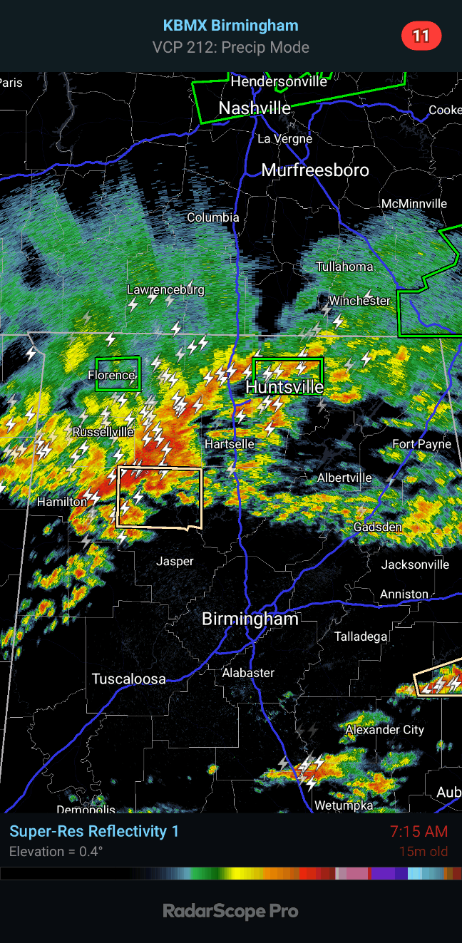
6:10 - Another flash flood warning issued for Huntsville.
6:12 - Hytop radar is down. Fortunately the squall line is far enough South that we can rely on the Birmingham radar, or technically it's down in Calera at the Shelby County Airport.
6:30 - Major delay on Birmingham radar now too but it sure looks like storms are staying below severe limits for now.
6:34 - And now the radar is up to date.
6:36 - Even that stronger storm cluster up around the Shoals is only expected to produce winds up to 30 mph.
6:44 - Got more strong storms moving through Marion County near Hamilton but also under severe limits.
Winds could gust to 40 mph though.
Rain moving into Cullman and Double Springs now.
6:51 - From about Littleville down to Moulton has been upgraded to a Severe Thunderstorm Warning. Winds could gust to 60 mph and hail could get up to about penny size.
6:55 - So some isolated problems are still possible in North Alabama over the next hour or two.
7:02 AM - Flash flood warning now for Florence.
7:10 - The only severe thunderstorm now is that one moving from Littleville to Moulton.
All those tan boxes are strong thunderstorms with gusty winds, maybe small hail, under severe limits.
Green boxes are flash flood warnings.
7:22 - Got potential for gusty winds and small hail with storms in Winston County too.
7:31 - At this point all storms have weakened below severe limits. The strongest storms are moving through Winston County and will soon affect Cullman County. Wind gusts up to about 40 mph and penny sized hail are possible in that part of the line/cluster.
SEL5
URGENT - IMMEDIATE BROADCAST REQUESTED
Tornado Watch Number 215
NWS Storm Prediction Center Norman OK
305 AM CDT Thu May 9 2024
The NWS Storm Prediction Center has issued a
* Tornado Watch for portions of
Northern Alabama
Extreme northwestern Georgia
Northern Mississippi
Middle Tennessee
* Effective this Thursday morning from 305 AM until 1000 AM CDT.
* Primary threats include...
A couple tornadoes possible
Scattered large hail and isolated very large hail events to 2
inches in diameter possible
Scattered damaging wind gusts to 70 mph possible
SUMMARY...A complex of thunderstorms is expected to move
east-southeastward over the watch area, episodically posing a threat
for damaging wind and tornadoes.
The tornado watch area is approximately along and 60 statute miles
either side of a line from 25 miles southwest of Oxford MS to 70
miles northeast of Huntsville AL. For a complete depiction of the
watch see the associated watch outline update (WOUS64 KWNS WOU5).
PRECAUTIONARY/PREPAREDNESS ACTIONS...
REMEMBER...A Tornado Watch means conditions are favorable for
tornadoes and severe thunderstorms in and close to the watch
area. Persons in these areas should be on the lookout for
threatening weather conditions and listen for later statements
and possible warnings.
&&
OTHER WATCH INFORMATION...CONTINUE...WW 213...WW 214...
AVIATION...Tornadoes and a few severe thunderstorms with hail
surface and aloft to 2 inches. Extreme turbulence and surface wind
gusts to 60 knots. A few cumulonimbi with maximum tops to 500. Mean
storm motion vector 29030.
...Edwards
WOUS64 KWNS 090800
WOU5
BULLETIN - IMMEDIATE BROADCAST REQUESTED
TORNADO WATCH OUTLINE UPDATE FOR WT 215
NWS STORM PREDICTION CENTER NORMAN OK
305 AM CDT THU MAY 9 2024
TORNADO WATCH 215 IS IN EFFECT UNTIL 1000 AM CDT FOR THE
FOLLOWING LOCATIONS
ALC033-043-049-057-059-071-075-077-079-083-089-093-095-103-127-
133-091500-
/O.NEW.KWNS.TO.A.0215.240509T0805Z-240509T1500Z/
AL
. ALABAMA COUNTIES INCLUDED ARE
COLBERT CULLMAN DEKALB
FAYETTE FRANKLIN JACKSON
LAMAR LAUDERDALE LAWRENCE
LIMESTONE MADISON MARION
MARSHALL MORGAN WALKER
WINSTON
GAC083-091500-
/O.NEW.KWNS.TO.A.0215.240509T0805Z-240509T1500Z/
GA
. GEORGIA COUNTIES INCLUDED ARE
DADE
MSC003-009-013-017-027-057-071-081-093-095-107-115-117-119-135-
137-139-141-143-145-161-091500-
/O.NEW.KWNS.TO.A.0215.240509T0805Z-240509T1500Z/
MS
. MISSISSIPPI COUNTIES INCLUDED ARE
ALCORN BENTON CALHOUN
CHICKASAW COAHOMA ITAWAMBA
LAFAYETTE LEE MARSHALL
MONROE PANOLA PONTOTOC
PRENTISS QUITMAN TALLAHATCHIE
TATE TIPPAH TISHOMINGO
TUNICA UNION YALOBUSHA
TNC003-015-031-051-055-061-071-099-101-103-109-115-117-119-127-
149-153-177-181-187-091500-
/O.NEW.KWNS.TO.A.0215.240509T0805Z-240509T1500Z/
TN
. TENNESSEE COUNTIES INCLUDED ARE
BEDFORD CANNON COFFEE
FRANKLIN GILES GRUNDY
HARDIN LAWRENCE LEWIS
LINCOLN MARION MARSHALL
MAURY MCNAIRY MOORE
RUTHERFORD SEQUATCHIE WARREN
WAYNE WILLIAMSON
ATTN...WFO...HUN...OHX...MRX...MEG...FFC...BMX...


No comments:
Post a Comment