

FORECAST:
Sunday (High 90, Low 67): Mostly sunny, muggy, and breezy during the day. Thunderstorms are likely late at night, and some may be severe.
Memorial Day (High 86, Low 70): Thunderstorms likely in the early morning - a few may be severe. Scattered showers and thunderstorms will gradually taper off during the rest of the day, with clearing expected by the night hours.
Tuesday (High 84, Low 60): Sunny. Mild.
EXTENDED OUTLOOK:
Wednesday (High 81, Low 59): Mostly sunny.
Thursday (High 79, Low 56): Sunny.
Friday (High 82, Low 58): Sunny.
Saturday (High 85, Low 60): Mostly sunny.
PRONÓSTICO:
Domingo (Máxima 90, Mínima 67): Mayormente soleado, bochornoso y ventoso durante el día. Es probable que se produzcan tormentas eléctricas a altas horas de la noche y algunas pueden ser severas.
Día de los Caídos (Máxima 86, Mínima 70): Es probable que haya tormentas eléctricas temprano en la mañana; algunas pueden ser severas. Las lluvias y tormentas aisladas disminuirán gradualmente durante el resto del día, y se espera que se despejen en las horas de la noche.
Martes (Máxima 84, Mínima 60): Soleado. Suave.
PERSPECTIVA EXTENDIDA:
Miércoles (Máxima 81, Mínima 59): Mayormente soleado.
Jueves (Máxima 79, Mínima 56): Soleado.
Viernes (Máxima 82, Mínima 58): Soleado.
Sábado (Máxima 85, Mínima 60): Mayormente soleado.
SEVERE WEATHER SAFETY:
Have a reliable way to get alerts. Do not rely on an outdoor siren.
Best is a NOAA Weather Radio with battery backup. Wireless Emergency Alerts on a cell phone are also a good source.
If you get a Severe Thunderstorm Warning, you need to get away from windows and preferably be on the lowest floor of a sturdy house.
If you get a Tornado Warning, the safety rules are:
* Stay away from windows.
* Get to the lowest floor.
* Get into a small room like a bathroom, closet, or hallway.
* Be near the center of the building. Put walls between you and the outside.
* Protect your body, especially your head, from falling or flying debris.
* Do not stay in a mobile home (trailer). Even a low spot on the ground outside is safer than that.
And of course, if you have access to a storm shelter, that is always best.
Here is a more detailed rundown of severe weather safety I wrote earlier in the Spring.
If anyone finds things that need correcting in the Spanish version of this below, please leave me a comment or send me an e-mail. It is something I'm trying at times, but it is far from perfect. Hope it is understandable to any native speakers who might benefit from it.
SEGURIDAD EN TIEMPO SEVERO:
Tenga una forma confiable de recibir alertas. No confíe en una sirena exterior.
Lo mejor es una radio meteorológica NOAA con batería de respaldo. Las alertas de emergencia inalámbricas en un teléfono celular también son una buena fuente.
Si recibe un Aviso de Tormenta Severa, debe alejarse de las ventanas y preferiblemente estar en el piso más bajo de una casa resistente.
Si recibe un Aviso de Tornado, las reglas de seguridad son:
* Manténgase alejado de las ventanas.
* Ve al piso más bajo.
* Entre en una habitación pequeña como un baño, un ropero o un pasillo.
* Estar cerca del centro del edificio. Ponga paredes entre usted y el exterior.
* Proteja su cuerpo, especialmente su cabeza, de escombros que caen o vuelan.
* No alojarse en una casa móvil (remolque). Incluso un lugar bajo en el tierra afuera es más seguro que eso.
Y, por supuesto, siempre es mejor si tiene acceso a una bodega contra tormentas.
Aquí están las pautas oficiales del gobierno para la seguridad contra tornados.
Si alguien encuentra cosas que necesitan corregirse en la versión en español de esto, déjeme un comentario o envíeme un correo electrónico. Es algo que intento a veces, pero está lejos de ser perfecto. Espero que sea comprensible para cualquier hablante nativo que pueda beneficiarse de él.


After some rain and thunderstorms around daybreak, we had a mostly sunny day in the Tennessee Valley. The High in Cullman was 86, and the Low was 66. Jasper saw a High of 90 and a Low of 70. Haleyville had a High of 86 and a Low of 69.
Huntsville had a High of 88 and Low of 68.
And Nashville had a High of 87, Low of 68.
There is a severe thunderstorm capable of 60 mph wind gusts and quarter-sized hail between Starkville and Columbus, Mississippi here at 5:10 PM.
Overall the rain has been pretty isolated even down in Central and South Alabama today. We've barely had anything close to us since early this morning around the break of dawn.
At this point our front is draped across the Mid-South and back through the Plains and Colorado as a warm front.


They're dealing with a significant threat for an outbreak of severe thunderstorms and tornadoes in the Plains again today, mainly in Oklahoma and Kansas, though the one tornado I saw reported so far was actually down in Texas. Tomorrow into tomorrow night, our region will be dealing with a much lower, but still respectable, threat for severe thunderstorms. And then on Monday, Memorial Day, things just look kind of messy with lingering rain as the front pushes through. I know it's not the easiest-going holiday forecast, but let's look into the details.


Tomorrow during the day I think we'll only have enough moisture for some clouds here and there, but staying mostly sunny, not much if any rain to deal with. And the High may actually reach 90. The Low tonight/in the morning near 67.
And we'll have a southerly breeze at times.

It's really overnight that we're concerned with. Looks now like a squall line will approach some time around Midnight or soon after. Along and just ahead of that line, we'll have to watch for storms becoming severe. And we'll take a look at that risk separately below the main discussion.


Monday, Memorial Day, the front will finish pushing through the region. The latest run of the GFS is a lot drier than other recent runs.

The latest run of the NAM looks more realistic for this time frame in this pattern. We should have some lingering scattered showers and thunderstorms on Monday, although as the day goes on, rain and clouds will be gradually decreasing from North to South. We should see the rain end by Monday night anyway. The High is expected in the mid-to-upper 80's, the Low near 70, really muggy night Sunday night into Monday morning.


High pressure takes over the region again on Tuesday, and we'll see sunny skies, a High in the lower, maybe mid-80's, the Low near 60 in the morning.


Then Wednesday we might see a few passing clouds, but mostly sunny with a High of 80 or so, Low near 60, maybe dipping into upper 50's.


Good northwest wind flow aloft on Thursday, sunny skies, High near 80, Low in the upper 50's.
The weather doesn't get much milder at the end of May.


Friday also looks sunny with a High in the lower 80's, Low in the upper 50's.


And then Saturday looks mostly sunny with a High in the mid-80's, Low near 60. Saturday will be the first day of June. And in meteorology, we consider that the first day of Summer. We leave it to the world of astronomy to wait on the Summer Solstice.


There is some risk of excessive rainfall with this system that could lead to flooding issues, but that risk is low.

But we all know that with severe thunderstorms, some places can get locally heavy rainfall in a hurry. So especially if we have any discrete supercell thunderstorms along or ahead of the squall line, those would carry a flash flood threat as well as the threat for large hail, damaging winds, or a tornado.


Now let's talk severe weather. The 4 km NAM is showing a squall line moving in after Midnight, about 1 AM it'll be coming into Northwest Alabama if this guidance is right, Monday morning. And notice a few more isolated storms forming ahead of the main line and then forming a secondary line by 2 AM. This is just a general idea, radar won't look exactly like this.
MESOSCALE DISCUSSION:


Between 1 and 4 AM it looks like that unstable air that cooked up during the day Sunday will still be with us, CAPE values of 1,500-2,000 joules/kilogram. That is high instability around here and more than enough to work with if we have ample wind shear.


Also between 1-4 AM this model is showing Helicity at the lowest kilometer of the atmosphere of between 200-300 m^2/s^2. That is plenty to support tornado development. In fact, this guidance strikes me as a little overblown, sort of like the regular NAM did yesterday.


This would lead to Significant Tornado Parameter values between 3-7, which is enough for a tornado outbreak. Again I think this model is overblowing how volatile the atmosphere will be. So let's look at the others while keeping this in the back of our minds.


The regular NAM shows a concerning combination of unstable air and wind shear too. It looks worst up around Wayne, Lawrence, and Hardin Counties in Tennessee and around the Shoals. Between 1-4 AM.

But even clicking in Cullman County for a forecast sounding, we've got CAPE between 1,500-2,000 joules and Helicity over 200 units even at the lowest kilometer of the atmosphere, STP values of 2-4 range. And that supports a tornado threat as well as a threat for large hail and damaging winds. The Supercell Composite value is 13. And the overall look is not good here, like most of it may just be a routine severe weather threat, but a few isolated spots may see more significant storm damage. Seems like we've had several events lately that were borderline like that, and our luck ran out with the May 8-9 thing, where we did have a lot of tornado damage in North Alabama. Let's take a look at the SREF. If it showing these same trends, then I'll be really concerned that the threat is ramping up. It is too soon for the HRRR. That's more of one to use the day of an event.


There is a lot to look at with the SREF this time. It does agree with the timing, between 1-4 AM is the prime time for severe weather. So that's the time frame we'll compare parameters. That also increases confidence that this will be an event that happens after midnight. Between about Midnight and Daybreak. But the models are in pretty good agreement that the most dangerous times will be between 1-4 AM, whatever severe thunderstorms do happen.
The dewpoints look like they will get to 65 or even 70 degrees. Really unstable air. After all, we're going to about 90 degrees tomorrow. And that muggy air is just going to sit there until the storms move in late at night/into Monday morning.


The 0-6 km bulk wind shear looks between 30-40 knots, enough to support severe thunderstorms.


The Convective Available Potential Energy via this model/ensemble is also showing up averaging about 1,500-2,000 j/kg which is another indicator of strongly unstable air.


But this is interesting. The Helicity values at 3 kilometers are struggling to reach 200 m2/s2, our basic baseline for tornadoes being able to form. Now with this strong of instability, it might overcome this weakness in the wind shear. But this does make me wonder if this will be more of a large hail/damaging straight-line wind threat than it is a tornado threat. Usually the SREF tones down the alarmist-looking stuff the NAM tries to throw out there.


This sure is some unstable air though. Lifted Index values are between -5 and -7. That's strongly unstable for us in this region. This is where you theoretically take a parcel of air and raise it up to 500 millibars or about 18,000 feet. Usually air cools as it rises, but with unstable air like you need for severe weather, you have these warm updrafts. So if you subtract the air temperature up there from the air down at the surface, the difference is actually negative. And when it gets to -7, that is some really unstable air to work with. We could have some major thunderstorm updrafts with this. The question is will they be likely to rotate.


And here at the lowest 1 km of the atmosphere, the SREF is showing the bare minimum of what we'd usually look for, to get rotating updrafts. The values of Helicity at 1 km are showing up about 100-200 units here. Now you do have to consider all parameters together, and anyone who knows a little weather history knows that in the cool season, we can get tornadoes with a lot of wind shear and only weak instability. But the same is true for really high instability and weaker wind shear. Sometimes a lot of one can make up for a lack of the other. So the idea of tornadoes is on the table, it just doesn't look alarming like it did via the NAM and the 4 km NAM. This might even be a lower-end tornado threat. If the instability was not so strong here, I'd be confident that if this model verifies, we'd have a lower-end tornado threat, with damaging thunderstorm winds being a lot more likely than a tornado in these storms.


I saw where Bobby Boyd, recently retired from NWS Nashville, posted that the mesoscale models were all over the place and struggling with this setup. And I agree. I'm paraphrasing my memory of what he said. The supercell composite numbers do ramp up around here though, especially over Northwest Alabama. And we'll have to keep an eye out for any storms becoming discrete, even if that happens just ahead of the squall line. The 4 km NAM made it look like between 1-2 AM, some might try to form that way and form a secondary line ahead of the main one somewhere in Northwest/West Central Alabama. Any trends like that will need to be monitored closely. Those storms might cause the most problems if they were to form as discrete supercells.


And this Significant Tornado Parameter Guidance rings true with me a lot more than what we saw from the NAM or high-res NAM. Most of us have a value of 1-2, with only a few places ramping up to a value of about 4. This model mainly shows that in Northwest Alabama and adjacent parts of Tennessee and Mississippi. I really think it could be anywhere that has that outside chance of getting a more significant storm, anywhere in this broad region that will have strong instability and at least enough wind shear to work with for severe thunderstorms and tornadoes.
So this supports mainly a basic isolated tornado threat across the region. But allowing for a few isolated places to maybe see an enhanced tornado threat at times. Looks most likely for somewhere in or around NW AL to be the hot spot (if there ends up being one) for a greater tornado potential around here, but I wouldn't take that to the bank. Just keep in mind that at least one or two places could see a much better environment for tornadoes than the rest of us during these wee hours.
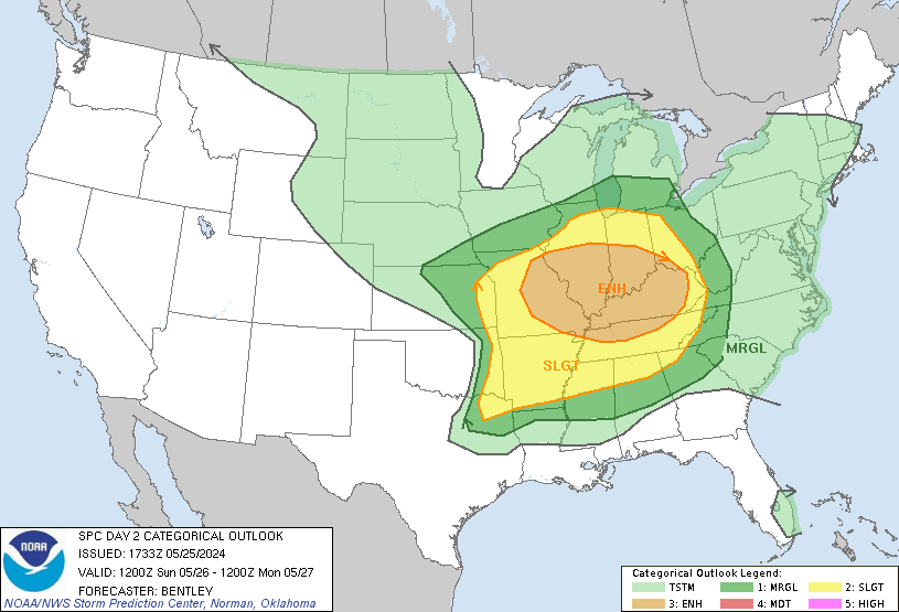


As of right now, all of the counties of North Alabama and Southern Middle Tennessee are outlooked for the basic Level 2/5 risk for severe thunderstorms tomorrow night. You have to go up to Northern Tennessee, Kentucky, Southern Illinois and Indiana, or Eastern Missouri to be under the Enhanced Level 3/5 risk area. And much of Central Alabama is only under the marginal Level 1/5 risk area.
The risk for particularly widespread or significant damaging winds or hail that would come from supercell thunderstorms is thought to be up in that general area of the Level 3/5 risk or where you see the hatching for wind and hail threats, a 30% hatched area. That's mainly North of Nashville up into the Ohio Valley. They could see winds of 75 mph or greater in some of those storms and hail at least golfball sized. Down here we have the more standard 15% risk for winds more likely to be about 60 or 70 miles per hour and hail at least quarter-sized.

And the Storm Prediction Center only has the standard 5% isolated tornado chance for Tennessee counties and basically North of the Tennessee River down on the Alabama side. South of the Tennessee River (approximately) is outlooked only for a minimal 2% tornado risk.
And the only enhanced area for a more significant tornado threat is fairly localized near St. Louis, Missouri.
I think this makes sense between the model forecasts for parameters and the synoptic placement of everything. They may upgrade our tornado potential a little tomorrow, like at least extend that 5% area further to the South, would be my guess. But I will leave that to them and not try to speak for them too much. Overall this outlook fits with my idea that most of us just have the basic threat for large hail, damaging thunderstorm winds, and isolated tornadoes around here. But I'm considering that a few of us might see a supercell thunderstorm, even if it is within or along the squall line, that does damage more like you'd expect in these hatched areas. And that could be extra-large hail/wind damage or a tornado with a longer track/fairly significant damage. I'm keeping that in mind as a lower risk. But for the most part, we just have a routine isolated tornado threat. And actually down here in Cullman, Winston, or Walker Counties, the formal outlook has our tornado threat minimal, even though the damaging wind/hail threat is the basic 15%.

To keep it simple, all of us in North Alabama and Southern Middle Tennessee have that basic Level 2/5 risk for severe thunderstorms tomorrow night into early Monday morning. The more likely threats are large hail and damaging straight-line winds, probably in a line of storms, called a squall line (or QLCS is another name for it). We could also see a few isolated tornadoes across this region though, especially if any storms become supercells along or just ahead of the main line. So wherever you will be in the wee dark hours of Monday morning, please have a safety plan ready to go within five minutes if you wake up to a warning. And have a reliable way to get warnings. You don't have to have an underground bunker, but you do need to get to a relatively safe place if severe weather threatens your area, and you are in a warning polygon. Good grief, this is a holiday where he honor people who died in military service. We wouldn't want anyone getting killed or seriously hurt by something as simple as a falling tree or a window blowing out. Simple measures can prevent people from getting hurt or sometimes even save lives. So let's do those and let people know.
For anybody who does follow my silly cat stories, I just want to note that Salem got whupped pretty bad by Stormy last night and ran out of the room, after he was really persistent in trying to buddy up to her. She is snarling and hissing at him less though with each night that goes by. And more importantly, she let me pet her a few times today and even started to purr. Before slipping back to old habits and swatting or biting me. The thing with this cat is, now that she's calmed down a little, usually when she swats like that, she cries, like you can tell she's just scared. I always knew she wasn't vicious by nature, even though the person who gave her to me called her the demon. And while it's nothing compared to getting ready for severe weather, that did really make me happy today, that I heard her purr for the first time since she's lived here. She and Salem also got some wet food, Fancy Feast for her, Sheba for him. That's what they are used to. He may not get any more wet food tomorrow though, because he chewed up my last set of headphones, even after I took them away from him and told him no. He got them again when I wasn't looking and chewed them up anyway. I bet he's torn up half a dozen sets of them since he first came to live here last year. At least he doesn't swallow the parts. Sometimes I think he's just as goofy as Stormy apparently does.
Anyway everybody be safe.


No comments:
Post a Comment