

FORECAST:
Friday (High 84, Low 67): Mostly cloudy. Numerous rounds of showers and thunderstorms are possible, and a few storms could be strong.
Saturday (High 85, Low 66): Partly to mostly cloudy. Scattered showers and thunderstorms are possible, and a few storms could be strong.
Sunday (High 89, Low 67): Variably cloudy with only isolated rain possible during the day. Thunderstorms are likely in the evening and night hours, and some may be severe.
EXTENDED OUTLOOK:
Memorial Day (High 84, Low 70): Gradually decreasing clouds with a 40% chance of lingering showers/thunderstorms.
Tuesday (High 80, Low 60): Mostly sunny.
Wednesday (High 78, Low 56): Sunny.
PRONÓSTICO:
Viernes (Máxima 84, Mínima 67): Mayormente nublado. Es posible que se produzcan numerosas rondas de lluvias y tormentas eléctricas, y algunas tormentas podrían ser fuertes.
Sábado (Máxima 85, Mínima 66): Parcialmente a mayormente nublado. Es posible que haya lluvias dispersas y tormentas eléctricas, y algunas tormentas podrían ser fuertes.
Domingo (Máxima 89, Mínima 67): Variablemente nublado y solo es posible lluvia aislada durante el día. Es probable que se produzcan tormentas eléctricas en las horas de la tarde y la noche, y algunas pueden ser severas.
PERSPECTIVA EXTENDIDA:
Día de los Caídos (Máxima 84, Mínima 70): Nubes que disminuyen gradualmente con un 40 % de probabilidad de lluvias/tormentas eléctricas persistentes.
Martes (Máxima 80, Mínima 60): Mayormente soleado.
Miércoles (Máxima 78, Mínima 56): Soleado.
Jueves (Máxima 81, Mínima 58): Soleado.
NOTE:
Sunday night is looking potentially kind of rough, so it would be a good time to review your severe weather safety plan. Hopefully this is the last time until about November, since we're nearly into summer now.


At 10:30 AM the latest observations show sunny skies in Cullman with a temperature of 75 degrees. The dewpoint is 70 degrees, making the relative humidity 83%. Winds are from the South at 6 miles per hour. The pressure is 30.00 inches and steady.
Skies are also fair in Jasper. The temperature is 82 degrees. The dewpoint is 73, making the relative humidity 74%. Winds are calm. The pressure is 29.98 inches and steady.
Sunny skies in Haleyville too, temperature of 80 degrees. The dewpoint is 67, and the relative humidity is 64%. Winds are South at 10 mph. The pressure is 30.00 inches/1014.3 millibars and holding fairly steady.
Elsewhere around the region, Fort Payne is partly cloudy and 76. Decatur is partly cloudy and 79. Huntsville is mostly cloudy and 78 degrees. Muscle Shoals is sunny but with some haze restricting the visibility to 7 miles this hour, temperature is 83 degrees there. Tupelo is fair and 78. Memphis has a thunderstorm, gusty winds, 69 degrees. And Nashville is partly cloudy and 80.
We've got a mesoscale convective system (basically a blob of thunderstorms on radar, some strong) pushing through Mississippi in our direction. So a lot of us will end up getting some rain and thunder this afternoon after all. Yesterday it was looking more isolated, but if I could update the forecast for today I'd bump the rain chance up to 50%. Will consider adjusting the rain chances up for tomorrow after looking at everything as a whole.
The pattern is going to remain unsettled through this weekend, and Sunday night into early Memorial Day, we'll actually have to watch for some organized severe thunderstorms. Before we get to some clear, milder weather Tuesday and beyond. So let's take a look at things.

First off, the main severe weather threat today stays back in the Plains up into parts of the Midwest and Dakotas. Nebraska is probably the hot spot today. Around here, any storms that can make it up to severe limits should stay pretty isolated, even if they are within the greater rain mass of this MCS late this morning into the afternoon.


Tomorrow the unsettled pattern continues as this high pressure ridge partly gives way to the frontal system. But we won't really get a frontal passage until Monday or Monday night. For tomorrow (Friday), I think the setup will be similar to today, with rain chances about 40-50% and a High of about 85, Low of about 66-67.

Again the better chance of severe thunderstorms, anything organized, stays to our West/Northwest, from the Great Lakes all the way back into Texas, looks like an active day maybe for Illinois, Arkansas, and places like St. Louis and Memphis. Around here, the chances of a thunderstorm reaching severe limits is very low. Most of our storms, even the stronger ones, will probably stay below severe criteria for damaging winds or large hail.


Then on Saturday I'm going to taper the rain chance down to 40%, so more scattered showers, a High in the mid-80's and Low in about the mid-60's.

Here again, we only have a very low chance for an isolated storm or two becoming severe. The organized severe weather should stay out in the Plains, especially in Oklahoma and Southern Kansas, places like Wichita and Oklahoma City will be in the hot zone for Saturday's stormy weather. We are not. We could have one or two storms try to get out of hand, but overall the threat is about what you'd expect from a typical summer's day, where you can have something like that, but most of the storms are just going to be regular thunderstorms.
So if you hear someone saying we have multiple rounds of severe thunderstorms possible, they are technically correct. But today through Saturday, the chances of severe thunderstorms in North Alabama and Southern Middle Tennessee is very low. If something does happen, the activity should stay pretty isolated. Even in the summer, you have to watch for stuff like that in the heat and humidity, with no cold front nearby. So I wouldn't get worked up about this first part of the holiday weekend. Just have a sensible plan for if you were to go under a Severe Thunderstorm Warning - best is a small central room (or hallway) near the center of a sturdy house, away from windows.


Then on Sunday, during the day it looks like our rain chances will be minimal. Highs will climb back into upper 80's after a Low in the upper 60's, and some of us, especially the cities (urban heat island effect) may reach the 90 degrees mark. Chance of rain only 20% during the day Sunday.
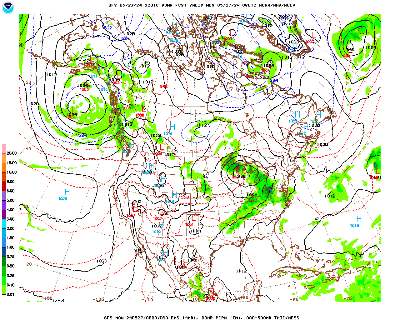
And then Sunday night, some thunderstorms ahead of that cold front will start to work in here. And this looks like organized thunderstorms. With the unstable air left over from the daytime heating and probably some good wind shear, and a cold front approaching, we may be dealing with organized severe thunderstorms from this system. Kudos to Elizabeth Leitman from the Storm Prediction Center for picking up on this a couple days ago, back when I still wasn't too impressed with it. That's why they are the experts on severe storms forecasting out there. Unfortunately this is at that perfect time range to be just beyond the scope of the models I trust the most for severe weather parameters like the NAM and the SREF. The GFS does continue to show very strong instability, more like in summertime, and enough wind shear to work with to support large hail, damaging winds, and at least a low-end tornado threat. It looks like the severe weather threat will be higher for Tennessee than for Alabama, especially Northern Tennessee up into Kentucky. But all of us will need to keep an eye on this. It is unfortunate timing, Sunday evening/night into Monday morning, which is Memorial Day.


Some severe weather risk will extend well into the Ohio Valley and back into the Mid-South. And we are included in the risk in North Alabama, all the way down to Cullman, Marshall, Winston, and Dekalb Counties, also Marion County in Northwest Alabama, while this is still 3-4 days out. But the main focus for the most organized severe weather, with potential for significant impacts, looks likely to be focused on areas North of Waynesboro and Shelbyville in Tennessee, up to much of Kentucky and back to places like St. Louis. Tomorrow and Saturday, the SPC will refine the threat areas and what types of hazards are most likely where. This system will also be within the range of the mesoscale models, like the NAM is usually the first one I look at. So we can look at what the atmosphere is probably going to be like going into this event. And that will help more clearly define the threats and placement of them.
But all of us need to pay attention to this. We could at least see a mesoscale convective system capable of large hail (maybe very large hail, especially in that enhanced 30% risk area), damaging thunderstorm winds, and at least an isolated tornado threat. Remains to be seen if anybody gets a more substantial tornado threat, but as much as I would dread that after earlier this month, that idea is on the table. Really don't want to speculate too much until at least tomorrow or late tonight when the mesocale models start to get a good look at what Sunday night/Monday morning's atmosphere is likely to look like.
Just remember to have a reliable way to get warnings. At least enable WEA on your cell phone, because that will get you Tornado Warnings or a Severe Thunderstorm Warning that carries the "Particularly Dangerous Situation" tag. Best is a NOAA Weather Radio with battery backup. Don't count on an outdoor siren, because frankly, that has gotten some people killed over many years now. It is ridiculous to rely on those anymore as your first way to get alerts, but some people still think they are reliable. They play a very limited role in getting the warning out, but I guess they help people who are out driving, or live right by one.
And if you live in a mobile home, have a plan to go quickly to a sturdier house or other strong building. Or if you don't know anyone who would let you in, have a plan to go to a public shelter. On the left side of this blog page, there is a list of useful links, and one of them is where a guy compiled all the tornado shelters in the country, so you can find the ones closest to you. Talk to them ahead of time to make sure they are open. Since it is a holiday weekend, hopefully you could spend the night with someone who has a sturdier house if you need to. Or if you're really lucky, maybe they have a basement. One thing I was very glad to learn when the dust settled from the May 8-9 event was that one of my family members in the path of what turned out to be a stronger tornado was visiting a friend who had a storm cellar. So she was actually underground when that tornado was passing nearby.
Nine times out of ten, you don't have to be underground to survive a tornado, and usually you can survive without serious injury, even if it does significant damage to a house. But you do have to do the right things.
You need to be in a smaller room like a bathroom, closet, or a hallway. You need to be on the lowest floor and away from any windows - those may be the most important points, besides making sure you are not staying in a mobile home. It's best if that room is near the center of the building, as many walls between you and the outside as you can get. And especially if there is a confirmed tornado, you need to cover your body in case of falling or flying debris, especially protect your head. If all you have is a blanket or two, or getting up under a table or set of stairs, that's what you use. If you have a good pillow, you can put that around the back of your head and neck while you take cover. Or if you have a small mattress to pull over your body that fits into your shelter area, also a good idea. I know a guy who does that for his kids if they have to get in the hallway. The best is probably a safety helmet like you wear for playing football. Or like you're really supposed to for riding a bike (but a lot of us don't . . . I almost never do riding a bike, but do sometimes during tornado warnings . . . my common sense can be variable). Even Theodore Fujita back in the 70's and 80's used to advocate for that, saying it can save a lot of lives in even the stronger tornadoes.
So just in case anybody gets a more significant event on Sunday, I'm trying to cover those bases. The tornado threat may end up being on the lower end for Southern Tennessee into North Alabama, but I'm started to get concerned enough that I don't want to give anyone a false sense of security, so that they'd become complacent. This is a holiday weekend, and whatever we get, it looks likely to happen in the dark hours. So I would err on the side of caution with this event in making plans, and if things look milder as we get closer to the event, we can all breathe a sigh of relief. After what we went through earlier in the month, I don't feel right about downplaying things too much, unless I see a logical scientific reason to.


We may still have showers and thunderstorms moving through during the day on Monday, Memorial Day, but I think any severe weather will wind down during the morning hours, probably by about daybreak or so. It is very unlikely that the atmosphere could recover for a second round of severe thunderstorms in this setup. Going to put the rain chance at 40% with a High in the mid-80's or maybe only lower 80's depending on how quickly the clouds and rain clear out, Low in the upper 60's or maybe 70 for some spots. The cold front will come through Monday and Monday night.


Then Tuesday, the GFS is showing a low risk of an isolated lingering shower or two, but I didn't see this on the ECMWF, and I don't think it's anything to worry about either way. Going to forecast a mostly sunny day with milder temperatures already setting up, a High near 80 and Low near 60.


Then on Wednesday, we have high pressure out over the Midwest and also in the Gulf of Mexico behind this front. Our weather should stay sunny around here, with a High in the upper 70's and a Low in the mid-to-upper-50's. Which is about as good as it gets in late May.


And then on Thursday, high pressure moving through the Ohio Valley, we should stay sunny with a High near 80, Low near 60, or actually with such dry air, probably looking at upper 50's again for Thursday morning.
And this is one of those times I think it's all right to peek into the land of tea leaves, beyond a week in advance. So let's do that now . . .


And wow, we have a disturbance showing up with more rain chances on Friday via the GFS.
The ECWMF is on board with the basic idea, so there might actually be something to it.
I'm probably not going to write a 10-day forecast up top, but if I was going to, I'd go with a High in lower 80's, Low near 60 or so, and only reintroduce a 20% chance of rain.


Then for Saturday June the 1st, the GFS shows us clearing out with high pressure moving in.

While the European model shows the system moving more slowly and absolutely covering the region up with rain. This is a good example of why I don't like to try 10-day-outlooks. This whole thing doesn't even look right. It looks like at least one of these models is smoking crack.
Things are usually not even that cut-and-dried in early June, where you either get a ton of rain or total sunshine. Usually it's more of a mix of sun and clouds and some lower-end rain chances. So I doubt either model has this right.
If I was forced to make a forecast here, like some people on TV probably are by the station management, whoever is concerned with getting higher ratings by having the best weather team, I'd bump the rain chance up to 30-40% here, probably only 30%, and forecast a High in the lower-to-mid-80's and a Low in the lower 60's.


The GFS continues to show clear conditions on Sunday June 2nd. The ECMWF does not go out that far for this run, at least not for the free, public graphics they make available. So I would just trim the rain chances back to 20% and forecast a High in the mid-to-upper-80's, Low more into the mid-60's here. The model guidance does not look too reliable, and I would mix in a lot of my personal experience of the local climatology. But I'm not going to put a forecast like that up top, because after looking at the model guidance beyond 7 days, I don't think it is reliable enough to post such a forecast after all. It would be an educated guess at best. Confidence is pretty good in the rest of the forecast, except some questions about timing and intensity (and placement of the worst weather) of storms Sunday night into Monday. I figured the Day 8-10 period would be peaceful enough like the Day 1-3 and Days 4-7 period, but I was wrong. With model guidance that messy, I'm not going to post a 10-Day Outlook. Since nobody is asking me to. That's the one major boon to being an amateur, being able to use your own judgement.

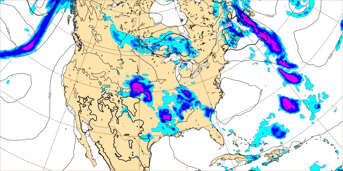
We'll see up to about two inches of rainfall during this forecast period (the next seven days, not the next ten days), and of course, with any especially strong thunderstorms, especially if any become supercells, you always run the risk of flash flooding. But for this event Sunday night into Monday, it looks like any flooding issues would probably stay isolated. If that changes, then the local Weather Service Offices will probably issue a Flash Flood Watch in advance. For now it looks more like a cluster (mesoscale convective system) of thunderstorms Sunday evening through the overnight hours until about daybreak Monday where some of the storms could be severe - damaging winds, large hail, and isolated tornadoes all possible.
For anyone wondering about the cat situation, the new female cat is named Stormy Sweetness, a grey tabby cat listed as three years old on the papers from the animal shelter in Decatur. I added the name Stormy because she is terrified and very suspicious and hostile to everyone for now, and also because I knew two households in the path of really stormy weather lately. Her personality makes the name Sweetness sound like a sick joke for now. Yet I saw her sweet side when I petted her at the other house. She won't let me pet her now, always panics at the last moment, starts crying, and goes back to hissing and swatting me.
Salem (whose last name is Nyarlathotep . . . I wanted to hear people try to pronounce it) is being very patient with her. The lady who donated Stormy to me is a different one than donated Salem last year. But she also gave me some of her things, including a "tower" that includes a little cubby hole room. Most of the time, Stormy sleeps on the very top of that (when she is not hiding in the closet) and grudgingly allows Salem to sleep in the cubby hole room two levels beneath her. She growls at him when he's climbing up the thing but does not bother him once he is in there. She just wants to be left alone and is obviously distressed by having to move around so much. They are sharing the same food, water, and litter. She just doesn't want him anywhere near her while she is eating or doing her other business. As long as they take turns and are not in the same living space, she's all right.
He tends to take her hissing and spitting in stride, just keeps looking at her with curiosity and makes that "chirrup" noise like cats do when they are trying to say hello and let somebody know they are friendly. He is a smart guy, and he seems to understand that she's just been through a really rough time and is afraid, not actually vicious. I think he would fight back if he knew she was just a bratty cat or something. But he seems to sense that she's just out of sorts and needs time to calm down and get to know us. Have to say I'm proud of the guy. He spent his first day here mostly hiding in the closet too, last year. He did get me to pet him extra the first day or two she was here, and started rubbing his head and marking things through the house like he did when he first moved in. But overall he does not seem threatened by her. Even though she is so hostile. It seems like he wants to help her chill out. My landlord actually told me it sounds like he will be a good brother to her, and I love that idea. She has a scar on her forehead and appears to have been severely abused. I agree with her previous owner on that. I don't know what all somebody did to her, but I'd like to give them a Mike Tyson level beating, maybe complete with biting their ears off. Instead I'm just doing what I can, which is mostly leaving her alone and making sure she's got enough food and water, and that I'm scooping the litterbox enough. She is doing very well under the circumstances. I did get a little aggravated with her last night when she kept swatting me to keep me from closing a window. But I used a pillow as a peacemaker between her paws and my hands. At this point in time, I'm not going to really punish her for anything. She is totally shellshocked. It's going to take some time for her to just realize that nobody is going to hurt her here. They weren't going to at the last home she had either, but things just weren't working out, was another place where she was not the only pet. She hasn't been here long, so overall I think she is doing great. I saw her more last night and this morning than any other night/morning since she's been here. Though she still looks out the windows and cries a lot, like she wants to get back "home".
Since I'm rambling about personal stuff, will note that things in my family tree are not quite as bad as I thought right after the May 8-9 tornado event. Been e-mailing with one of the people who had a close call and saw two of the others when they stopped by on the way back from a birthday party. I don't know that I've ever had that happen before though. I guess other than the April 27, 2011 event, where there were just so many tornadoes that I had to check on everyone, the closest would be the Good Friday Outbreak of 2009. One of my siblings was at MTSU when they had a close call with an F-4 tornado, and that same day, there was an F-3 in Marshall County, Alabama, where I was living with my other brother. But my brother in Tennessee was able to get into some kind of basement while the tornado came close to them. Said it was the most intense thunderstorm he'd ever seen. And the one in Marshall County really passed pretty far to the East of Arab, think it was near the town of Grant. I remember that it crossed Lake Guntersville, which made for a great picture somebody took. But it's rare to have two parts of the family have a close call with a pretty damaging tornado in the same day.
If I seem extra vigilant about any chance of severe weather, that is why. I guess the stuff on the Tennessee side shouldn't have been that much of a surprise, but the way things exploded in North Alabama that evening and night did surprise me. And those supercells were aiming for the same basic path. Trying to stay objective and scientific about it, I think we do need to watch Sunday night into very early Monday morning, the morning of Memorial Day, because it could get at least somewhat organized again. And the potential for severe weather is real. The details need to be ironed out over the next day or two. But it looks like an event where we could see organized severe thunderstorms, and we can't rule out some places seeing significant damage, especially within that 30% enhanced threat area. (And like I say, they'll refine that outlook area tomorrow and more so Saturday, the Storm Prediction Center.) We'll see how much ends up being large hail/damaging winds versus a tornado threat. I'd especially watch it for Northern Tennessee up into Kentucky though with this one. And we still need to watch it in Northern Alabama into Southern Middle Tennessee. The potential is real, even if it ends up being on the lower end. Let people know about it, since this is a holiday weekend.
Trying not to "wishcast" as I heard some NWS employees refer to it when I was going to school for meteorology, but it'd be nice if this threat turned out to be on the lower end. That could happen, but it could also continue to look concerning, or even look more concerning, tomorrow and Saturday as we look at all the new data.
So I'm not really worried about the low-end severe thunderstorm chances today through Saturday. Sure, something isolated could get out of hand somewhere in our region. And it's reasonable to be prepared for that, just in case. But those odds are very low. Most of it is just going to be regular rain and thunderstorms. And I don't believe in making every tiny chance of severe thunderstorms sound like a really big deal.
I am growing more concerned about Sunday evening through Monday morning for a more organized, maybe even fairly significant severe weather potential. It looks worst for roughly Nashville and points North through most of Kentucky and the Southern parts of those states like Illinois and Indiana. But we really need to look at the mesocale stuff tomorrow to define the risk areas more clearly and what kinds of threats are more likely where. And then that will be fine-tuned on Saturday. Most of Sunday should be dry, but then when we do get the thunderstorms Sunday evening or more likely late at night, some of them may be severe. And we do need to respect this potential, unless something happens to make it look a lot less concerning.
It's really good to respect any severe weather threat, but the very low chances of it we have today through Saturday are more something to keep a casual eye on, certainly nothing to get worried about. I would really watch the Sunday night threat more carefully, and wherever you will be for the holiday weekend, have a reasonable plan where everybody could get to safety. You wouldn't want to get caught in a mobile home with a really dangerous thunderstorm coming, or especially one that was producing a tornado. It doesn't take an unusually powerful tornado like they had in Iowa the other day to cause major problems for the people it hits directly, and there really is no safe place to be in a mobile home during a tornado. You need to be out of it. If you're in a frame house or the lowest floor of an apartment building, and you shelter properly, odds are you will be just fine (i.e. not injured - not saying you won't be scared by it . . . that even happens to storm chasers sometimes) even if you do take a direct hit from a tornado. If you're extra worried about it, then either take extra precautions in covering your head sheltering in place, or get to a public shelter before the storms arrive at your location. Or like I say, with the holiday, if you know somebody with a good sturdy house or especially if they have something like a basement, this would be a time to take advantage of that. And if they're really a good friend, they'll be glad to help you out. After all, this is a holiday dedicated to people who gave their lives in military service. Usually we can prevent people from losing their lives from severe weather if we work together on it.
I have to say I'm hoping any of the severe thunderstorms miss me this time. The thought of being in that closet with two cats, both of whom are going to be agitated, and one of whom is way too happy with using her claws when uncomfortable, is not a pleasant one. And I'm guessing if she hears thunder, she will be in that closet ahead of the other two of us. Sort of hoping if it comes to that, her wiser instincts will kick in, and she'll realize that I'm looking out for all of us. If I'm wrong about that, then I might have to have stitches . . . not from the storm, but from a cat with a stormy temperament.
So have a laugh at that and relax. I hate that the holiday looks messy, but just wherever you will be, have a basic safety plan in place, just in case we do get really organized severe weather Sunday night. We're close enough to the event that it's worth mentioning even though the details are not all that clear yet. I probably wouldn't cancel plans to go visit whoever, but I'd keep up with the weather and make sure there was a safe-enough place to go if a dangerous storm was coming.
I spent an absurd amount of time on this post, but it got interrupted by a few things at times too. So I may have repeated myself.


No comments:
Post a Comment