FORECAST:
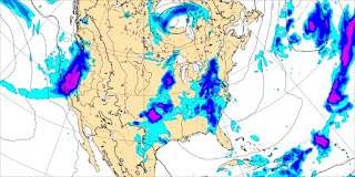
Friday (High 81, Low 65): Partly to mostly cloudy with scattered showers and thunderstorms possible throughout the day. Rain showers will become more numerous at night.
Saturday (High 80, Low 62): Partly to mostly cloudy with scattered showers and thunderstorms still possible. May the Fourth be with you . . .
Sunday (High 83, Low 62): Partly cloudy. Widely scattered showers and thunderstorms are possible.
EXTENDED OUTLOOK:
Monday (High 84, Low 63): Partly cloudy with a 30% chance of showers/thunderstorms.
Tuesday (High 85, Low 63): Partly cloudy with a 20% chance of showers/thunderstorms.
Wednesday (High 86, Low 65): Partly cloudy with a 20% chance of showers/thunderstorms.
Thursday (High 87, Low 66): Partly cloudy with a 30% chance of showers/thunderstorms.
READING TEA LEAVES:
Friday May 10th (High 85, Low 66): Partly to mostly cloudy with a 40% chance of showers/thunderstorms.
Saturday May 11th (High 82, Low 64): Partly cloudy with a 20% chance of showers/thunderstorms.
Sunday May 12th (High 80, Low 58): Mostly sunny.
PRONÓSTICO:
Viernes (Máxima 81, Mínima 65): Parcialmente a mayormente nublado con posibles lluvias y tormentas eléctricas dispersas durante el día. Las lluvias serán más numerosas por la noche.
Sábado (Máxima 80, Mínima 62): Parcialmente a mayormente nublado. Aún son posibles lluvias y tormentas dispersas.
Cinco de Mayo (Máxima 83, Mínima 62): Parcialmente nublado. Es posible que se produzcan lluvias y tormentas eléctricas ampliamente dispersas.
PERSPECTIVA EXTENDIDA:
Lunes (Máxima 84, Mínima 63): Parcialmente nublado con un 30 % de probabilidad de lluvias/tormentas eléctricas.
Martes (Máxima 85, Mínima 63): Parcialmente nublado con un 20 % de probabilidad de lluvias/tormentas eléctricas.
Miércoles (Máxima 86, Mínima 65): Parcialmente nublado con un 20 % de probabilidad de lluvias/tormentas eléctricas.
Jueves (Máxima 87, Mínima 66): Parcialmente nublado con un 30% de probabilidad de lluvias/tormentas eléctricas.
LEYENDO LAS HOJAS DE TÉ:
Viernes 10 de Mayo (Máxima 85, Mínima 66): Parcialmente a mayormente nublado con un 40% de probabilidad de lluvias/tormentas eléctricas.
Sábado 11 de Mayo (Máxima 82, Mínima 64): Parcialmente nublado con un 20 % de probabilidad de lluvias/tormentas eléctricas.
Domingo 12 de Mayo (Máxima 80, Mínima 58): Mayormente soleado.
NOTES:
They've had numerous rounds of severe weather in the Midwest and Plains lately. The National Weather Service in Omaha has put together the best page on it I've seen so far.
Some of the stuff in the Plains got pretty weird.
Tomorrow is the anniversary of a historic tornado outbreak, but not for the Southeast, for our neighbors out in the Plains. They remember May 3, 1999 well.
DISCUSSION:
It was a mostly sunny day in the Tennessee Valley, though clouds have been increasing as we get into the evening hours. We've had a breeze at times, and winds have been variable, but generally out of the South/Southeast. The High in Cullman was 84 with a Low of 55. Jasper saw a High of 88 with a Low of 55. And Haleyville's observations are missing for much of today, but the highest temperature for the day we do have on record is 81, and the Low appears to have been 56 this morning. Huntsville had a High of 87 and Low of 62. And I just have to say, it is starting to feel like summer, even if it's about a month early. Since when did the seasons obey the calendar anyway? Nashville is another site that has several hours missing from the observations today, but it looks like a High of about 84 and Low of about 63. Kind of hard to tell with some hours of the day missing, but we'll make do with what we've got.
The Hollister/Loveland tornado was not a wedge. This is the path of the tornado. This is about a 1/4 mile west of the home it passed over. pic.twitter.com/L3fchITFOz
— Photojournalist Michael Beard (@MichaelBeardWX) May 2, 2024
Here is the house damage I was thinking about, that I saw while scrolling earlier. If this tornado had been as bad as it looked on radar, there is no way that house would have survived with only E/F-1 damage. We'll see when there has been more time to analyze the event. Maybe there was a brief period it was unusually strong, that caused those scary radar signatures. But you really have to be careful. I remember a tornado that came through West Central Alabama a few years ago, that had such a strong TDS (Tornado Debris Signature) that it was called a "violent" tornado on the air, but then ended up being rated F-2 at its strongest point.
Really fascinating radar loop. Not only is this an intense tornado with GTG wind speeds of 250+ MPH, you can see it occlude at the end of the frame and retrograde back to the west.
— Andrew Markowitz (@amarkowitzWX) May 1, 2024
This is near Hollister, OK - all in the path please take shelter immediately #OKwx pic.twitter.com/4JJeb1aVL6
And here's a look at the scary radar presentation from yesterday in Oklahoma. As great as these tools are, they are not infallible. This tornado might have done more damage if it had hit a more populated area, but the one house I've seen that it hit survived remarkably well for a tornado that looked that bad on radar. Who's to say that this wouldn't be another one that would have proved less than catastrophic even if it did hit a populated area?
The reality out of this multi-day severe weather outbreak in the Plains and Midwest has been bad enough. The death toll has been lower than would be expected with such a tornado outbreak, but there was still some loss of life.
I'm not going to jump on the hype train when I take the time to post a blog. A tornado can look like it'll make history on radar and then only do enough damage to be rated an E/F1-F2. I think that's what happened just East of Hollister. If it did reach the intensity we saw on radar, it must have been briefly, while it was out over open country. Even then though, there are damage indicators like ground scarring and debarking of trees that would give a clue to rate the tornado higher. So I'm not quite sure what went on there yet. Just something to talk about.
And just for fun, will post the text of that survey in bold, along with the survey for the anticyclonic tornado that also happened last night in Oklahoma. As Rick Smith said, it was some stuff you don't see every day.
.East of Hollister...
Rating: EF1
Estimated Peak Wind: 105 to 110 mph
Path Length /statute/: 6 miles
Path Width /maximum/: 1200 yards
Fatalities: 0
Injuries: 0
Start Date: 04/30/2024
Start Time: 09:32 PM CDT
Start Location: 2 ENE Hollister / Tillman County / OK
Start Lat/Lon: 34.36 / -98.83
End Date: 04/30/2024
End Time: 10:12 PM CDT
End Location: 5 ENE Hollister / Tillman County / OK
End Lat/Lon: 34.38 / -98.80
Survey Summary:
This tornado produced EF1 damage, although it was likely much
stronger. The tornado was first observed by a storm chaser around
932 pm. The tornado moved east through very rural areas producing
occasional power pole, tree and outbuilding damage. The tornado
turned northeast and damaged two farmsteads about 6 miles east-
northeast of Hollister. The tornado then turned west-northwest
and dissipated about two miles northeast of where it began.
.Anticyclonic Tornado Northwest of Grandfield...
Rating: EF1
Estimated Peak Wind: 95 to 100 mph
Path Length /statute/: 2.1 miles
Path Width /maximum/: To be determined
Fatalities: 0
Injuries: 0
Start Date: 04/30/2024
Start Time: 10:18 PM CDT
Start Location: 2 SSE Loveland / Tillman County / OK
Start Lat/Lon: 34.27 / -98.75
End Date: 04/30/2024
End Time: 10:32 PM CDT
End Location: 2 WNW Grandfield / Tillman County / OK
End Lat/Lon: 34.25 / -98.73
Survey Summary:
Estimated path of anticyclonic tornado. Some tree damage was
observed with this tornado, and investigation continues which
may further define the path.
&&
A tornado 1200 yards wide is still more than a half-mile. So if this had hit more structures, maybe it would have been rated E/F2-F3. It seems like if it was stronger than that, the structures it did hit would have been destroyed or at least more heavily damaged, and that you'd see trees debarked like you typically see with the E/F4-F5 tornadoes.
If I'm going to read all the yacking about it on Twitter/X, then I'm going to try to bring some logic to the conversation too.
It does strike me as an odd situation, since it did hit a few structures, which only sustained enough damage to get it an F-1 rating. It was almost an (E) F-2 by the estimated wind speeds (105-100 mph). Based on those crazy radar signatures, I would expect a random house it hit to be levelled. But that is not what happened.
Wow. 4 panel reflectivity from the FDR 88-D Radar of this tornado east of Hollister, Oklahoma going from the surface (top left) to 15,000ft ARL (bottom right).
— ☈ Chris Jackson ☈ (@ChrisJacksonSC) May 1, 2024
Never. Have. I. Ever. Seen. Anything. Like. That. pic.twitter.com/GCAFatSOPh
It really did look awful on radar. I can see why people got really excited by it.
They actually have another severe weather risk today/tonight, though it's mainly in Texas this time.
And again tomorrow, Texas is the main focus, though something isolated could develop elsewhere in the Plains.
Then on Saturday, the chances are marginal for anything severe even in Texas.
Monday might pose another risk for organized severe weather in the Plains.
Technically our severe weather season is not over until the end of May. But this pattern favors keeping the severe stuff to our North and West for the foreseeable future. The waters are awfully warm this year, so we'll have to watch the tropics from June to about November. Around here, I guess that beats just complaining about the heat.


No comments:
Post a Comment