

FORECAST:
Sunday (High 92, Low 74): Partly to mostly cloudy, hot and humid. Scattered showers and thunderstorms are possible, mainly in the afternoon and evening.
Monday (High 89, Low 68): Sunny. Lower humidity.
Tuesday (High 91, Low 66): Mostly sunny. Lower humidity.
EXTENDED OUTLOOK:
Wednesday (High 92, Low 70): Partly cloudy with a 20% chance of showers/thunderstorms.
Independence Day (High 93, Low 72): Partly cloudy with a 30% chance of showers/thunderstorms.
Friday (High 94, Low 74): Partly cloudy with a 20% chance of showers/thunderstorms.
Saturday (High 93, Low 73): Partly cloudy with a 30% chance of showers/thunderstorms.
BEACH FORECAST:
Sunday (High 90, Low 81): Mostly cloudy with numerous showers and thunderstorms possible. Hazardous rip currents are expected.
Monday (High 91, Low 78): Partly cloudy with scattered showers and thunderstorms possible. Hazardous rip currents are still possible.
Tuesday (High 89, Low 79): Partly cloudy. Scattered showers and thunderstorms are possible.
Wednesday through Saturday (Highs ~90, Lows ~80): Partly cloudy with a 30% chance of showers/thunderstorms.
PRONÓSTICO:
Domingo (Máxima 92, Mínima 74): Parcialmente a mayormente nublado, caluroso y húmedo. Es posible que se produzcan lluvias y tormentas aisladas, principalmente por la tarde y la noche.
Lunes (Máxima 89, Mínima 68): Soleado. Menor humedad.
Martes (Máxima 91, Mínima 66): Mayormente soleado. Menor humedad.
PERSPECTIVA EXTENDIDA:
Miércoles (Máxima 92, Mínima 70): Parcialmente nublado con un 20 % de probabilidad de lluvias/tormentas eléctricas.
Día de la Independencia (Máxima 93, Mínima 72): Parcialmente nublado con un 30% de probabilidad de lluvias/tormentas eléctricas.
Viernes (Máxima 94, Mínima 74): Parcialmente nublado con un 20% de probabilidad de lluvias/tormentas eléctricas.
Sábado (Máxima 93, Mínima 73): Parcialmente nublado con un 30% de probabilidad de lluvias/tormentas eléctricas.
PREVISIÓN DE LA PLAYA:
Domingo (Máxima 90, Mínima 81): Mayormente nublado con numerosas lluvias y tormentas eléctricas posibles. Se esperan corrientes de resaca peligrosas.
Lunes (Máxima 91, Mínima 78): Parcialmente nublado con posibles lluvias y tormentas eléctricas dispersas. Todavía son posibles corrientes de resaca peligrosas.
Martes (Máxima 89, Mínima 79): Parcialmente nublado. Es posible que se produzcan lluvias y tormentas aisladas.
De Miércoles a Sábado (Máximas ~90, Mínimas ~80): Parcialmente nublado con un 30 % de probabilidad de lluvias/tormentas eléctricas.


It was a partly cloudy day across the Tennessee Valley with only a few isolated showers and thunderstorms to break up the heat and humidity a little. The High in Cullman was 91, and the Low was 75. Jasper had a High of 95 and Low of 73. Haleyville saw a High of 93, Low of 74. Huntsville had a High 96, Low of 77. Can see the urban heat island effect there. Same goes for Nashville, where they saw a High of 96 and Low of 78.
We basically are under a ridge of high pressure right now but can get some Gulf moisture, typical summer stuff. Our temperatures are definitely hotter than they normally are this early in the season, though we're nearly into July, so I guess they won't seem as strange. We're under a heat advisory tomorrow because of the combination of heat and humidity making it feel like about 105 degrees or so. And people can get just as sick if they are overexposed to it, same as if it really was that hot. Our humidity around here can be a doosie, as we all know.


Tomorrow a weak frontal boundary will be pushing into the region. Our rain chances will ramp up, but I think they still cap off at 40%, which means scattered activity for the most part. Should see a High of about 92-93, Low of about 73-74.


Monday looks like a brief shot of drier air behind that front. Skies should be sunny, High in the 88-90 range, Low about 68-70.


Then Tuesday looks like another day where rain chances are so low, not worth even worrying about. Skies should stay mostly sunny. The High should be near 90, the Low in the upper 60's because the air will be dry enough to allow good radiational cooling Monday night.

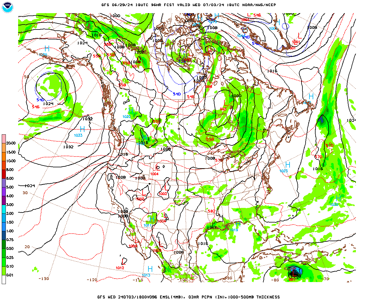
Then on Wednesday, it looks like we'll be back to the usual standoff between high pressure and enough moisture to kick off isolated showers and thunderstorms in the region. Notice also the GFS shows Hurricane Beryl approaching Jamaica. The weather looks typical for the time of year around here, High of 90 or so, Low of 70 or so, mix of sun and clouds, only that minimal 20% chance of a shower or thunderstorm.


And even though the GFS wants to increase our rain chances slightly for Thursday, the 4th of July, this scenario is not supported by the ECMWF. So a rain chance of 20% again looks reasonable. If I decide to increase it, it'll only be to 30%. I'll only do that if it looks like the right call after looking back over the overall pattern. After taking it one day at a time like this. High should be in lower 90's regardless, Low in lower 70's.


Basically the same thing on Friday. We can split hairs on the exact percentage of the rain chances, but overall it's just looking hot and humid, High in lower 90's, Low in lower 70's, any rain or thunderstorms staying pretty isolated.


Then at the end of the forecast period, Saturday looks like a mix of sun and clouds, rain chances staying in the 20-30% bracket, Highs in lower 90's, Lows in lower 70's.
And some of you may have noticed that the GFS does show Hurricane Beryl surviving into the Gulf of Mexico and moving in the direction of the Texas/Northeast Mexican coast. It is too soon to make the call with any official forecast. We have to see how things trend once it gets into the Caribbean, where it will likely encounter significant wind shear by the time it gets to about Jamaica. And then if it gets into the Gulf of Mexico, all the data will have to be evaluated carefully to see where this thing is most likely going.
I did notice the ECMWF gives it a far more southerly track. It has been the best at forecasting some hurricanes in the past, even one I think can think of more than a decade ago (Sandy). But before speculating too much on this, I'd wait until it at least gets into the Caribbean Sea, see how things are trending then. And all the computer models have to be taken into account along with past experience with tropical cyclones under different conditions. People have to fly in and take observations so the models have the best data to work with. A lot goes into forecasting hurricanes. If you ever want to learn about them thoroughly, I'd check out the book Divine Wind by Kerry Emanuel.

Watching the Bay of Campeche where a tropical depression could still form before this broad area of low pressure moves into Mexico early in the new week. So that could bring them some heavy rains in Mexico/Central America.
Got another area of low pressure producing disorganized showers and thunderstorms in the Eastern Atlantic a few hundred miles Southeast of the Cabo Verde Islands. It will probably form into a tropical depression by the middle of next week, but any chances for development before then are looking on the low end.
Between those two systems, we have Hurricane Beryl, which continues to intensify under ideal conditions, unusually warm ocean temperatures and no wind shear to hamper it for now.
.gif)

And it is expected to become a major hurricane by the time it passes over the Windward Islands, where a Hurricane Warning is now in effect. Actually several warnings or other advisories are in effect issued by the governments of several different countries that are in charge of different islands out there. I posted the official stuff from the National Hurricane Center earlier where it references all that.
Anyone vacationing down that way needs a hurricane safety plan.

Our rain chances around here are staying low for the most part, though the coverage of it might be more numerous at times tomorrow. In general rainfall totals should stay under a half-inch around here for the next week.


No comments:
Post a Comment