

FORECAST:
Tuesday (High 85, Low 69): Partly cloudy, muggy, and breezy with isolated showers and thunderstorms possible during the day. Thunderstorms are likely in the evening and night hours, and some may be severe.
Wednesday (High 79, Low 62): Sunny. Staying breezy.
Thursday (High 78, Low 59): Mostly sunny. Still breezy, turning cooler.
EXTENDED OUTLOOK:
Friday (High 72, Low 50): Mostly sunny.
Saturday (High 73, Low 51): Partly cloudy with a 20% chance of showers.
Sunday (High 80, Low 57): Partly cloudy with a 30% chance of showers/thunderstorms.
Memorial Day (High 79, Low 61): Mostly cloudy with a 40% chance of showers/thunderstorms.
Now is a good time to review your severe weather safety plan.
PRONÓSTICO:
Martes (Máxima: 85, Mínima: 69): Parcialmente nublado, bochornoso y ventoso, con posibles chubascos aislados durante el día. Es probable que haya tormentas por la tarde y la noche, algunas de ellas podrían ser severas.
Miércoles (Máxima: 79, Mínima: 62): Soleado. Ventoso.
Jueves (Máxima: 78, Mínima: 59): Mayormente soleado. Ventilado, con tendencia a refrescar.
PERSPECTIVA EXTENDIDA:
Viernes (Máxima: 72, Mínima: 50): Mayormente soleado.
Sábado (Máxima: 73, Mínima: 51): Parcialmente nublado con un 20% de probabilidad de lluvias.
Domingo (Máxima: 80, Mínima: 57): Parcialmente nublado con un 30% de probabilidad de chubascos.
Día de los Caídos (Máxima: 79, Mínima: 61): Mayormente nublado con un 40 % de probabilidad de chubascos.
Es un buen momento para revisar su plan de seguridad ante condiciones climáticas adversas.
DISCUSSION:
We've had a mostly sunny day overall in the Tennessee Valley. There were a few isolated showers and thunderstorms, but most of those happened in the wee hours of the morning. And it has been breezy at times, winds generally from the South/Southwest. The High in Cullman was 84, and the morning Low was 66. Jasper saw a High of 88 and Low of 70. Haleyville had a High of 85 and Low of 67. And Huntsville saw a few more clouds than the rest of us today, but still a really warm day, High of 86 and Low of 69 there.
If I'm understating the warmth, it runs in the family. My Papaw on my father's side of the family used to give out soup or hot cocoa and say, "It's warm, now." And then if we slurped it too fast and scalded our tongue, he'd give his wonderful, unique belly-laugh. Saying he told us it was warm.
Some of us try to find excuses for our insanity. At least in this case it's mild. I promise I can get worse if y'all would like to see that . . .
But no. Let's be serious this evening. Because we do have some potential for severe thunderstorms tomorrow/tomorrow night. And while a joke or two doesn't hurt to lighten the mood at the beginning of a forecast discussion, we need to take this somewhat seriously.


And here just after 7 PM CDT we do have a few showers and thunderstorms moving through our region. A lot of that stuff over North Alabama is so light it's probably evaporating before reaching the ground. But in far East/Northeast Alabama we do have a couple little thunderbumpers. And then some activity North of Chattanooga, also some thunderstorms moving into Nashville. And even some stuff there along the TN/KY border.
But these storms are not severe despite our muggy airmass.


Right now the organized severe weather is well out to our West, lots of thunderstorms producing severe winds/hail and even some flash flooding along with a few tornadoes. And here I'm only showing one out of the 3-4 Tornado Watches in effect out there. And there are some Severe Thunderstorm Watches out that way too.

Looks like five confirmed tornadoes out in the Plains today, numerous reports of large hail, scattered reports of wind damage.


And let me correct something I said above: That storm moving through Nashville did briefly reach severe limits, but then pulsed back down quickly, a lot like our storms of summer can do sometimes. This is not the organized severe weather threat they are dealing with out West tonight and that we'll be dealing with tomorrow evening/night around here. That front is finally going to move through the region. It has been stalled, waffling back and forth, causing all kinds of problems for a long time. We've mostly avoided its wrath, but tomorrow evening, we'll have to watch things.
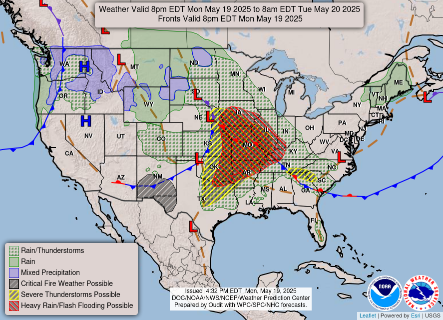


Above you can see an overview of what's going to happen: The cold front finally moves through here tomorrow night, and then behind it, high pressure moves into the region bringing cooler, drier air in its wake.
Now let's dig into the details of the forecast models.
But first let's take a look at the current upper-air data. We're fortunate that our local offices in the Southeast/Tennessee Valley can still do the standard two radiosonde launches twice a day, 7 AM and 7 PM CDT. (In Standard Time it's 6 AM and 6 PM. It's 12Z and 00Z hours Universal Time.) Mostly the data from these get crunched up in the initialization of the computer forecast models, so they can run their equations with much better information, putting observations all over the country (and some models use data from all over the world) into the initial picture of the weather. But it's also important for human forecasters to look at these locally and get an idea what the atmosphere is trying to tell them. And that's why I've started trying to remember to slow down and look at these things instead of just leaving that to the computers to assess.

The sounding at Birmingham (or technically the Shelby County Airport) shows a temperature of 81 and Dewpoint of 68 this evening. We've got strong surface CAPE, above 1,500 j/kg. Lifted Index is -6, so we've got fairly strong instability already. Lapse rates are decent. Wind shear is weak, especially the Storm Relative Helicity both at 3 km and 1 km. We currently don't have enough wind shear to support a tornado threat or really even much threat of any organized severe thunderstorms with damaging winds.
However, that will change tomorrow as the cold front gets closer, and all those pressure changes happen. Atmospheric pressure and winds are closely related.
The sounding from Nashville is not available yet, so checking out the one from Jackson, Mississippi instead.

And the air is even muggier down there, temperature of 88, Dewpoint of 70. And the CAPE - (available energy for storms) is over 2,300 joules. Wind shear is enough to support a severe thunderstorm with damaging winds, but the helicity is so weak, no worries about a tornado down that way right now, if a storm were to come through.
Again, conditions will change tomorrow as the front gets closer.
So let's look at the model projections. I'm going to brush over the main forecast before adding anything about the severe weather threat, which I'll put at the bottom in a mesoscale discussion. Mesoscale means a more local, short-term picture of the weather. What you're seeing looking at the fronts and everything for the whole country is called the synoptic scale. So we'll do the synoptic scale first.


Most of the day tomorrow looks dry overall with only a chance for isolated showers and thunderstorms. Tomorrow evening and night, thunderstorms will become likely, and some of those may be severe. Look for a High of 84-85 and a Low of about 69-70.
We'll have a good southerly breeze again, a mix of sun and clouds most the day. Of course clouds will increase in the evening/night hours as the squall line (and any isolated supercell storms) move closer.


Thursday looks mostly sunny as well with a High in the upper 70's, Low in the upper 50's. Latest guidance not showing it quite as cool as this time frame looked yesterday.


Friday still looks like our coolest morning, mostly sunny skies, starting the day about 50 degrees or so (a few places might see upper 40's but don't think Cullman and surrounding areas are likely to dip quite that cool . . . Huntsville or up into Tennessee, a definite possibility) and then only warm into the lower 70's in the afternoon.


The GFS shows quite a bit of moisture returning to the region on Saturday.


The ECMWF is showing a good bit less moisture and also shows our upper-level flow staying more from the Northwest. I think this solution is closer to being right.
Going to keep the rain chance down at only 20% and forecast a High temperature in the lower 70's again, a Low of about 50 or so again, lower 50's.


On Sunday again I question how accurate the GFS is in bringing this much moisture back to the region. It was showing a much more modest amount of moisture available in previous runs, I remember yesterday evening for sure.


But I have to take a step back and give the American model some credit here, because the European model is showing a similar look for Sunday.
Still only going to bump the rain chance up to 30% which means widely scattered showers and thunderstorms possible, about a 3-in-10 chance that your street gets one. Look for a High near 80, Low in the upper 50's.


And what's actually going on here, might not be so clear with this raw model output, is that a reinforcing cold front is expecting to move through here on Thursday (why mentioning a few clouds that day), and then next weekend starting on Saturday, that front lifts back northward into the region far enough to warm us up again and to serve for a focus for rain and thunderstorms to move East/Southwest through our region again.


And unfortunately the ECMWF has an even wetter look for Monday, which is Memorial Day, than the GFS does. A fair amount of people, people who have the day off work, may have outdoor activities planned. So this is not the best news.
Still going to keep the rain chance at 40% for now, which means more scattered off-and-on rain than it's likely to be a total washout for everybody. The High should be around 80 and the Low in the lower 60's.
Obviously the best days to get stuff done outside (like actual yardwork and whatnot) is Wednesday through Friday, for people who have some time then.

Most of us will see rainfall totals of about one inch over the next seven days, but in Northeast Alabama up into Tennessee, a lot of places may see closer to 1.5-2 inches of rain totals.
MESOSCALE DISCUSSION:


The NAM is showing supercells getting going, possibly starting in Southern/Middle Tennessee and Northeast Mississippi, at about 7 PM tomorrow evening. And this is just a rough guideline of what the radar will look like. Looks like storms will be at least trying to form into a squall line or some clusters by 1 AM.


Instability looks really strong at 7 PM tomorrow, over 2,000 joules of surface-based CAPE. That's a powder keg of energy. The wind shear is fairly strong too, about 100-150 m^2/s^2 of Helicity for a lot of us at that time. And that's enough to support a tornado threat along with the threat for large hail and damaging winds.

The Energy-Helicity-Index is somewhat concerning areawide but looks primed in Southern Middle Tennessee, around places like Waynesboro, Lawrenceburg, Pulaski. That general zone back into Northwest Alabama/Northeast Mississippi may turn out to be the hot zone for supercells to initialize in the beginning. Or at least the zone when they ramp up and start doing damage.

Taking a forecast sounding from around Smith Lake, we've got very strong instability, ample wind shear/helicity, a Supercell Composite of 12, Significant Tornado Parameter in the 2-3 range.
So this supports all modes of severe weather - large hail, damaging winds, and tornadoes in the region. There could be an isolated instance or two of a tornado that stays on the ground longer with more significant damage, as well, especially since (at least at first) we're likely to be dealing with supercell thunderstorms that are out by themselves.
Let's look at the SREF ensemble since it usually isn't quite as alarmist as the NAM.


This is some strong instability, dewpoints expected to be in the 70's at 7 PM tomorrow evening. That's more like summertime. That's really strong for May around here.
The wind shear, bulk shear between 0-6 kilometers up, is about 40 knots. And that's enough to have severe weather when combined with this kind of instability and a cold front coming through.


CAPE values around 2,000 j/kg again shows strongly unstable air in place. Helicity at 3 km is about 200 units, which is enough to support a tornado threat, though it's along the lower end of what we'd usually look for with a tornado threat. Having said that, sometimes high instability can compensate for marginal wind shear. There have even been some significant tornadoes through history that have come out of an environment with a lot of unstable air and not a ton of helicity, but enough helicity. And this is enough.


Lifted Index is tough to read from this map. I can tell it's somewhere between -3, -5, or -7 around here. But those lines are drawn close together without great labelling this time. Any of those values is enough to be concerned with.
Helicity down at the lowest kilometer of the atmosphere is 100-150 units, which again, is not really high but is sufficient for there to be at least a low-end tornado threat with these storms.


Supercell composite values averaging around 10, which is pretty significant, but the Significant Tornado Parameter is more like 1-2, which is more of an isolated tornado threat. Once you get to 2 or above you do have to start paying attention in case of a stronger tornado that could stay on the ground longer than the average. A lot of people don't realize, the vast majority of our tornadoes only do enough damage to be rated E/F0-F1.


The HRRR has an interesting look, trying to simulate the radar tomorrow. It has a broken line of supercells up in Tennessee as early as 1 PM and then more of a squall line moving through North Alabama between about 7-11 PM.
The HRRR throws out a lot of garbage scenarios, but when it does get things right, I've seen it nail things that no other model picks up on. It is a short-term CAM model - Convection Allowing Model. Sometimes these are the most reliable when an event is only a day or several hours away. They just have to be used with wisdom and their output balanced against the other model data. You have to use common sense and evaluate all this stuff.

It shows a Significant Tornado Parameter of 3-6 at 7 PM, which is probably overblown, considering that it's also calling for a squall line to have formed by this time. Once the squall line forms, there will still be some risk of a tornado developing within it, or especially if it breaks up somewhere, but usually higher STP values like this would be seen when we're still dealing with discrete supercells.
Still it's worth taking into account that at least a place or two in our region could deal with more significant tornado damage tomorrow, especially if a tornado develops from one of those earlier discrete supercells, because a squall line (or if you believe the NAM simulation, several clusters) develops.


That's in line with the latest SPC outlook. The Storm Prediction Center has expanded the Enhanced Level 3/5 Risk to include all of the Tennessee Valley counties of North Alabama and Southern Middle Tennessee, and correlated with that is a 10% hatched area for a tornado threat. This means there is a chance of a tornado that might do enough damage to have to be rated at least E/F-2 occurring within 25 miles of any given point here.


And I'll zoom in, but you can see that I spoke true. It's all of us. Even folks in places like Birmingham and Gadsden are close enough to this enhanced risk that includes a tornado threat, that they'd be wise to take this seriously, even though they are "only" in the 5% basic isolated tornado threat level, technically.


Sometimes these weather systems can be humbling, and I have to say, a few days ago, I thought large hail would be the main threat with this one. Now the hail threat is just looking fairly routine for a severe weather threat.
While the damaging wind threat is looking high.


The chance for damaging thunderstorm winds is looking quite high, with most of us having a 45% risk of thunderstorm winds doing damage with these storms.
So again, it is all hazards with thunderstorms that become severe tomorrow/tomorrow night.
The most likely hazard is just damaging winds. Many trees and power lines could come down tomorrow, and minor structural damage could happen, especially to mobile homes.
There is also a risk for tornadoes, especially in the early storms that will form as discrete supercells before they form into a squall line (or into clusters, but I think it'll be a squall line this time). One or two places in our region could see more significant tornado damage than the average. If a tornado comes out of a discrete supercell, it could stay on the ground a while, have a fairly long track. But any tornado is dangerous. And they certainly can happen in squall lines too.
And in the mix, we could see large hail in these storms. If it's in the squall line, the hail will probably be about quarter-sized. In any discrete supercells that were to form and have a long track, we could be looking at more like golfball-sized hail.


The onset time might be a little sooner for Tennessee. I'd start watching things even in the early afternoon there. But for the most part, this looks like an evening/night threat for North Alabama and Southern Middle Tennessee.
We'll see supercell thunderstorms that slowly merge into a squall line (or maybe clusters, but I'd bet on a squall line for this one). Damaging winds, tornadoes, and large hail will all be possible. Isolated instances of flash flooding cannot be ruled out either, especially in the wake of any sustained supercells.
Everybody be safe. Weather looks great behind this, but some of us may have some problems out of this system.
📻NWS BIRMINGHAM NOAA WEATHER RADIO OUTAGE THROUGH MAY 21ST - WHAT YOU SHOULD KNOW: ⬇️ pic.twitter.com/OIKBZzkbPA
— NWS Birmingham (@NWSBirmingham) May 19, 2025
9:28 PM Note - I'd forgotten about this, but the National Weather Service in Birmingham is upgrading some software. And NOAA Weather Radio will be offline, all of their transmitters there in Central Alabama for this event tomorrow night. Here is their info about that.
If you can afford it, I'd use WeatherCall as an alternate source.
But at least enable Wireless Emergency Alerts on your phone. That will get you Tornado Warnings but will only give Severe Thunderstorm Warnings if they carry a PDS (Particularly Dangerous Situation) tag. Also gives Flash Flood Warnings and Amber Alerts.
And an old idea not many people use now: Turn on a regular radio that you know will cut in for severe weather. (If you can put batteries in there for backup, that's best, but just do the best you can.) If you are in Central Alabama and tune to 90.3 FM WBHM, the classical music/NPR station, you are very unlikely to be able to sleep through a warning. That abrasive EAS tone is especially jarring when you're sleeping to classical music and sometimes a DJ that sounds like they're on sedatives. And that's what we need in a situation like this. Nobody needs to doze off if a damaging thunderstorm or a tornado is coming at them during this event. They need to wake up and be able to get to a safe place.
I think it is likely that 101.5 FM in Jasper cuts in for severe weather since they post it on Twitter/X. But I have never listened to them during a severe weather event, as I have to use internet to pick them up. So I can't say for sure. If you're familiar with that station more and trust them, that's great. Or any station, but make sure you know you can trust them. Good music is not the point with this. The point is that you will WAKE UP if a severe storm is coming. Like we saw yesterday morning in Tuscaloosa County and points East, it does not always take a tornado to cause some problems. And the folks at the Cullman library could tell you that from a couple summers ago, when they had some windows broken out by straight-line wind damage. Cell phone WEA is great, but it rarely tones for damaging winds like it will for a tornado warning. So we're all going to have to use our heads to get through this event, more than usual.
North Alabama, Cullman and points North, should be fine. But people who use the Winfield transmitter (Channel 6) that alerts for Walker, Winston, Fayette, Marion, and Lamar Counties will not be able to use NOAA Weather Radio tomorrow night. It is unfortunate, and I'm just trying to let you know how to work around this.
At the time they first announced this outage, planned outage, a few days ago, Tuesday did not look like a particularly threatening time for severe thunderstorms around here. And now it does.


No comments:
Post a Comment