Tuesday: Sunny. Cool morning, mild afternoon. High 75, Low 47
Wednesday: Partly cloudy and breezy during the day with isolated showers/thunderstorms possible. At night, rain is likely, and any thunderstorms that form will be capable of hail and strong winds. High 78, Low 53
Thursday: Thunderstorms likely. Some possibly severe, especially going into the night hours. High 73, Low 61
Friday: Breezy with gradual clearing. High 66, Low 54
Saturday: Mostly sunny. High 57, Low 37
Sunday: Sunny. High 60, Low 34
Monday: Mostly sunny. High 63, Low 36
At 11 AM it is overcast in Cullman with a temperature of 66 degrees. The dewpoint is 64, which makes the relative humidity 94%. Winds are from the Southwest at 16 miles per hour, with some higher gusts up to 28 mph. Despite having some light rain, fog, and mist earlier this morning and clouds covering the sky now, visibility is back to 10 miles. The pressure is 29.74 inches and falling. Our Low this morning only got down to 59. And there were times this morning that the visibility has gotten down to 4 miles.
Muscle Shoals is overcast and 71, winds gusting up to 32 mph there. Huntsville is also breezy, overcast and 68. Overcast and 74 in Tupelo. Rain and fog, 66 degrees in Nashville, winds gusting to 35 mph there. Gadsden also at 66 degrees back on the Alabama side of the border. Jasper is overcast and 72. They've had periods of light rain down that way too. Haleyville is overcast and 67 degrees. It is raining in Fort Payne. They are at 65 degrees, and visibility is currently down to 7 miles.
Next SKYWARN class is Wednesday March 8th at 6 PM in Trinity, Morgan County, at the town hall. The very next night, also at 6 PM, there is a SKYWARN class being held at Haleyville city hall in Winston County. This class was originally supposed to be on the 16th of February but had to be rescheduled because of severe weather potential.
They sure had an interesting severe weather event out in the Great Plains last night.
It was mainly damaging thunderstorm winds (unusually high winds even for severe thunderstorms, like 80-100 mph range sometimes), but there were a few tornadoes in the mix too. One tornado came close to hitting the Storm Prediction Center in Norman, Oklahoma. Sounds like everyone there and on the campus of OU was okay, but it was a close call. They are really smart about making sure people have proper shelter there anyway.
The showers associated with this front will be clearing the area from West to East this afternoon and evening. We might get up to about 70 degrees before sunset.
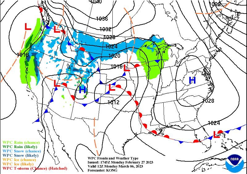
Tomorrow will be sunny around here, while snow and ice continue over the Rocky Mountains, the Pacific Northwest, up through the Dakotas and Great Lakes and even up into New England. They haven't caught much of a break from the snow lately. Around here it looks like a High of about 75 tomorrow and a Low tonight of about 47.
Then on Wednesday, rain chances will come back, but during the day, I think any showers will stay isolated. At night, rain and storms become likely.
We will have to watch for a few storms on Wednesday evening/night trying to reach severe limits, main threats would be large hail and damaging straight-line winds. This risk does also look to be on the low end.
Should be breezy, partly cloudy, High near 78, Low rebounding into lower 50's, about 53 in the morning as more moisture return gets in here. Wednesday night should get windy and clouds increasing, and like I said, rain/thunderstorms likely, with potential for an isolated severe thunderstorm or two.
Then Thursday is the main show, when the front moves back through the region. Thunderstorms are likely, and we should see a High in the lower 70's, Low of about 60 or so.
Started to show raw model parameters for severe weather potential, but really no point in it until tomorrow, since this system is just barely within reach of the SREF and the NAM now, and the GFS guidance doesn't really line up with those. Will stick to the main points. First let's look at Friday's overall weather.
That system will be lifting out to the Northeast. That Low is in a favorable position to support severe weather if the unstable air and wind shear also come together right.
The GFS guidance for midnight between the two days makes this look like an especially strong storm system.
It looks like Friday will be a day of gradual clearing, with storms and rain probably moving out by about Noon. High should be in the 60's and Low in the 50's, breezy conditions as the front moves out.


The Storm Prediction Center is already highlighting the storm system for Thursday/Friday as a potential regional severe weather outbreak. All modes of severe weather will be possible if the ingredients continue to come together right: large hail, damaging thunderstorm winds, and tornadoes. Notice that enhanced 30% area - that's a basic idea of the places expected to have the best potential for significant damage from storms. We'll keep an eye on this and try to fine-tune the details of timing, placement, intensity of storms starting tomorrow. The models will be working with better information once the weather is clear from today's system, and this will be within a decent range for the SREF and NAM to evaluate. It does look like an overnight event, Thursday night into early Friday morning, for the Tennessee River Valley, where we are.
Behind that front, high pressure and a shot of cold air moves in. We'll be mostly sunny on Saturday with a High in upper 50's, Low in mid-to-upper-30's.
Then for Sunday, sunny skies, High edging up to near 60, starting out the day only in the mid-30's or perhaps even lower 30's.
Then on Monday the High shifts to the Mid-Atlantic region. Looks like plenty of sunshine hanging around and a High in lower 60's, Low in mid-to-upper-30's.
Average rainfall totals for this period should be between 1-3 inches, with the higher amounts more likely up across the Tennessee border. But along with the threat for severe storms Thursday into Friday (and actually we could get a little something Wednesday night trying to go severe, as early as that), we have to watch for flash flooding issues for areas where storms train over the same area repeatedly. And of course a really bad storm can dump a lot of rain in a short period of time. So if you live in a flood-prone area, might want to think about that. And be careful driving, never want to cross a flooded roadway. That actually kills more people every year than severe thunderstorms or tornadoes.


No comments:
Post a Comment