Wednesday (High 65, Low 36): Sunny. Patchy frost possible in the morning.
Thursday (High 71, Low 39): Mostly sunny. Still pretty cold in the morning.
Friday (High 78, Low 53): Windy with increasing clouds and perhaps a stray shower or thunderstorm during the day. At night, thunderstorms are likely, and some of those at night may be severe.
April Fools Day (High 76, Low 63): Thunderstorms likely early - some possibly severe.
Sunday (High 72, Low 41): Sunny.
Monday (High 77, Low 52): Increasing clouds with a 30% chance of thunderstorms.
Tuesday (High 80, Low 61): Thunderstorms likely - possibly severe.
Here are the latest tornado surveys from last Friday night.
And we have a SKYWARN class tomorrow evening in Decatur, another in Huntsville Thursday evening. That will wrap up the National Weather Service in Huntsville's basic storm spotter classes for this season. They do have another online advanced class scheduled for the end of May. I have a gut feeling that there may be a lot of examples to draw from for that class. So good timing on their part. The ones tomorrow and Thursday night are at the Alabama Institute for the Deaf and Blind and are meant to accommodate people who have limited or no sight or hearing.
The National Weather Service in Nashville continues its Weather101 classes through the season too.
So another day where that frontal boundary is kicking up storms along the Gulf Coast, some of which are still becoming severe.
We've also got that upper-level trough moving through Eastern Texas and Oklahoma. That feature will bring us some clouds today, probably not any rain enough to notice, if any at all. Should see a High of about 69 or 70. Could have a bit of a breeze at times today as that shortwave moves through.
We've currently got clear skies in Cullman with a temperature of 50 degrees, which is our Low for the morning. Dewpoint is 45, making the relative humidity 82%. Winds are variable, generally been from North or Northeast overnight, currently at 5 miles per hour. The pressure is 30.12 inches and rising. Clear skies and calm winds in Jasper with a temperature of 54. They also got down to 50 degrees earlier this morning. Haleyville has a few clouds and 50 degrees, winds from the North at 9 mph.
Tomorrow high pressure moves into the region, and we will have a cold morning due to low humidity levels. Low should be about 36-37 and then the High in the afternoon should get up to 64-65 under abundant sunshine.
We'll stay dry on Thursday as the high pressure system shifts up to the northern parts of the Mid-Atlantic seaboard. Skies will stay mostly sunny, and the High will rebound into the lower 70's, the Low rebounds to roughly 40 degrees, might stay in upper 30's.
Would not be impossible to see some patchy frost somewhere (especially up along and North of Tennessee border) one of these cold mornings. And remember that until you get into the second week of April, can always have a late-season freeze. So take that into account when planning when to plant anything. If we get past the first week of April and no signs of any freezing or borderline-freezing temperatures coming up, then I think you're good. But to play it safe, at least get through the first week of the new month and check the forecast for the second week. If you want to play it safe.


Then on Friday, things get interesting again as far as the severe weather we expect during the spring season but especially as we are getting into the month of April. This is actually the day before we get into April, March 31 here, but storms don't read the calendars and stay on a strict schedule. We've got (according to the GFS model, and the other global models are in pretty good agreement) a strong low pressure system and an upper-level trough taking on a strong negative tilt. Synoptically it is a setup for organized severe weather, perhaps a significant event shaping up. And as I say, it is the right time of the year for that, even the right time of our tornado season to have to watch for a really organized, significant threat for severe storms.

The Storm Prediction Center has extended the basic 15% outlook risk for severe weather to include North Alabama and most of Tennessee already. Though the main focus of this event is expected to be more in the Midwest down through places like Arkansas and near Memphis. That's where you see the enhanced 30% risk level. This looks like a setup where both lines of storms and supercells will be possible, so as I say, it looks like at least for some parts of the country outlined here, it could turn out to be a fairly significant severe weather event. Tornadoes will be possible as well as damaging thunderstorm winds and large hail.
Mississippi is included in the risk for severe weather, of course, and they have really had it rough lately. I was glad to see some of the storm chasers, especially the ones who were on the Rolling Fork tornado, making efforts to help out the people in that poor community who lost so much. That's not an area where you can really build basements, and I think it's a pretty safe bet that few if any of these people had access to one of those bank-vault-strength FEMA-certified safe rooms. I'm glad for the people who survived by getting into the most central, lowest part of a sturdy house. And that works most of the time. But this tornado has been given a preliminary rating of F-4. And when you've got shabby building codes (which I strongly suspect was the case here), even F-3 winds can blow apart an entire house. And with a tornado like that, if someone stays in a mobile home, and gets hit, they may stand almost no chance of survival. And the reality is that a lot of people can't afford more than a mobile home, unless they want to rent in an area that may be high-crime. So when I look at the pictures or skim over the surveys, I kind of feel for the people who were in the path. And it's nice to see the contrast now with the behavior of chasers in the past sometimes, like the people who were whooping and hollering, driving recklessly trying to see the tornado that hit Tuscaloosa and Birmingham in 2011. I'm glad some of the chasers now are doing the right thing and realizing how serious a situation like this is. Maybe things have improved some after 2011 after all. I think it was mainly Ryan Hall and his buddies I noticed making the relief efforts. We've had some good chasers around here too. He's no longer with us, but I remember Mike Wilhelm watching that Tuscaloosa tornado, and if you go and watch the unedited raw footage of him and his chase partner (whose name escapes me, but it wasn't Brian Peters . . . he went chasing with Tim Coleman that day . . . they caught the Cordova tornado and even punched the core to get to it . . . Tim later said if anybody tried to get him to core-punch again, he was putting them in a sleeper hold), they were basically saying an impulsive, informal prayer, along the lines of, "Oh . . . God . . . help these people." Because if you know what a storm like that can do, it is really rough to play out in your imagination even before it hits. A broadcast meteorologist whose name I always forget in Northern Mississippi got ridiculed by some jerk on social media for "praying" like that on the air as the tornado was hitting Amory, Mississippi Friday night. That guy does have a quirky personality that gets him noticed from time to time, but I don't necessarily see that as a bad thing. A few years ago, I remember him getting grouchy with his partner, John, for goofing off at the wrong moment, when a storm produced a tornado faster than they got back in the swing of things. Found it, his name is Matt Laubhan. I usually hate when I get off on a tangent like this, but I found where
Mr. Laubhan was able to speak for himself. And he even says that it wasn't planned, it just came out in a moment he was overwhelmed. This truly was a tragedy for people in Mississippi. This guy had already seen the reports out of Rolling Fork, and I think Silver Springs was the other place hardest hit, and then the same supercell was producing an extra-strong tornado about to hit Amory, MS. Anybody who wouldn't have a visceral reaction to that would probably be drinking on the job, or sedated in some worse way. And I'm not even sure that would numb somebody to it.
I remember what it was like after the April 2011 superoutbreak around here, when we had our first even marginal threat for severe thunderstorms again in May. A lot of people were still looking for a new roof over their heads, and people were trying to clean stuff up and rebuild. And I can only imagine that folks in Mississippi are feeling a real sense of dread with this next severe weather threat. I hope someone is able and willing to set up some kind of a shelter that people in the places already hit can come to, good strong building with a good central space where people could take shelter if the luck of the draw goes against them. I really could relate to that one chaser who posted that after what he saw this past Friday night, he wasn't even sure how soon he would be able to chase again. I remember in 2011, I felt like if I never saw another tornado in my life, I'd be good. And I did see a tornado that day. It was during the midday round, saw a tornado from Huntsville that the best I remember, started in Decatur. A place I used to live was hit by one of the F-4 tornadoes, and had to be bulldozed. The silver lining was that I noticed, if we'd still lived there, and been in my brother's closet, at the very center of the house, we probably would not have had a scratch. It removed most of the roofing and destroyed most of the two other apartments on each side though. And just up the road from there, there were numerous houses that looked bigger and stronger, and they might as well have been hit with a bomb. It made me sick at my stomach to see. Tornadoes like that are rare, but man, when they happen . . . you can't get away from it living in this part of the world. It's one of life's not-so-nice sides.
The High on Friday should get into the upper 70's, Low in the lower 50's. Clouds will be increasing, and winds will pick up, but the most we might see during the day is an isolated shower or thunderstorm. The main action comes at night, and those storms may be severe.
If one thing might limit our severe weather threat with this, it is how far North the surface Low is expected to track. And you notice on the outlook for Friday through early Saturday morning that I showed from the SPC, the really hot zone, focal point, is in the Midwest, because of the position of the Low. We do still have some severe weather risk here though, and it'd be foolish to blow it off, especially after last weekend.
The ECMWF still wants to move this front through a little more slowly than the GFS on Saturday. So there are times I wonder if this will be more of a Saturday morning threat. We'll have a better handle on the timing over the next day or two.
The GEM keeps showing the slower timing on Saturday too. And it's kind of funny because Saturday is April Fools Day. Almost joking, but I'm trying not to let the weather fool me for that day. There was actually a tornado outbreak that day in 1974 sort of like a prelude to the really bad outbreak on the night of the 3rd and morning of the 4th. Just to be clear, we're not expecting anything on that level. We already went through our generation's version of that in 2011. But I remember J.B. Elliott saying after that event that any tornado outbreak that does a lot of damage anywhere is hard to take, and that the Smithfield tornado was almost as bad as the 1974 outbreak. And this last event reminded me, all it takes is one. Even seeing that Rolling Fork stuff from such a distance has been tough.
And I know there are other problems in the world. If I wanted to comment at length about the tragic news out of Nashville yesterday, for example, I'd need to get a political column or news blog. But if you pay attention to weather, sometimes it will take you aback how much of an impact the really severe stuff has on the people affected.
On Saturday it looks like a High in the mid-70's and a Low in the lower 60's. I think the clearing trend will be gradual on Saturday, and we may have storms still going on well into the morning hours, maybe past daylight. It looks like things are trending that day, so I think I'm going to blanket both Friday and Saturday with likely thunderstorm chances and mention of severe potential.
Then on Sunday a high pressure system over the Ohio River Valley brings us dry conditions again, plenty of sunshine, not much of a cooldown during the day, expecting lower 70's, but Sunday morning the Low should get down into the lower 40's again. So like I say, we're going to have some cold snaps even through the first week or sometimes first two weeks of April just based on climatology, what's happened in the past.
Beyond that on Monday and Tuesday, we do have another system coming at us. But the spread between the global models is just a big mess. We probably will be dealing with more storms, but as far as the severe weather potential, it is too soon to tell. I tend to think some of us might have a chance of severe weather just based on how things usually go in a very active pattern like that this time of the year. Whenever you've got another system coming a couple days after a strong storm system, you have to keep an eye on both of them, which is hard to do. But when we get into April, especially as active a season as we've already had, I favor a play-it-safe attitude.
Monday the rain and storms look pretty widely scattered, Highs rebounding well into the 70's, Lows near 50.
Then Tuesday night, I don't like where the GFS puts the surface Low. This is highly questionable as a forecast, but considering temperatures are expected to get up to about 80 degrees during the day Tuesday, I think I will go ahead and mention another severe weather risk here. The Storm Prediction Center actually mentioned in their discussion that they were watching this time period as well but did not have enough solid data to back up outlining a risk area yet.
It does look like the severe weather parameters may be weakening on Friday Night/early Saturday morning as the storms move into our area.
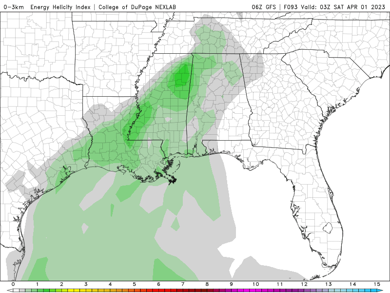
Forecast soundings make it look a lot like last week's event, with low instability but strong wind shear. The wind shear is not quite as pronounced this time, but it is still strong enough that even with weak instability and the Low being well to our North, should support a threat for a few tornadoes in the region as well as severe thunderstorms capable of straight-line wind damage.


I'm already concerned about next Monday and Tuesday though. I don't trust the exact timing this far in advance, especially with a storm system to get out of the way before this second one. But for both Monday and Tuesday afternoon, the GFS is already showing CAPE values well in excess of 2,000 j/kg and Helicity values in excess of 200 m^2/s^2. And if that model guidance were to verify as to the position of the surface Low as the front comes through, along with that strong instability and wind shear, conditions could be ideal for a severe weather outbreak around here. So it's early to speculate too much, but definitely need to keep an eye on this one and see how things trend over the next few days. It looks potentially much more significant than whatever we get this weekend.
Rainfall totals will probably average up to an inch for this forecast period.


No comments:
Post a Comment