

Please stay sheltered for this as supercells like this (watched it since Mississippi) can cycle up and down quickly. Play it safe.

10:21 - Note that our severe weather threat is expected to continue for at least another couple hours, they may have to extend watch over into Georgia. Stay sheltered in these tornado warnings even though the storms appear to be weakening somewhat - that doesn't always last, and it is hard to tell at night just from radar data. Better safe than sorry with these.
.png)
10:24 - Downtown Huntsville stay sheltered. This storm has knocked out power for a lot of people athough no tornado confirmation so far.
.png)
10:28 - Also a good idea to stay sheltered in Eastern Marion and Franklin Counties and even in that broad severe thunderstorm warning upstream that affects especially Lawrence County.
10:31 - The tornado warning was let go for Franklin County but still continues for Marion, and definitely for Madison and Jackson County.
10:35 - Okay, thankfully the tornado signatures have weakened and gone away, and we have no more tornado warnings. We only have severe thunderstorm warnings. Will start a new post.
603
WFUS54 KHUN 020411
TORHUN
ALC071-083-089-020445-
/O.NEW.KHUN.TO.W.0014.230302T0411Z-230302T0445Z/
BULLETIN - EAS ACTIVATION REQUESTED
Tornado Warning
National Weather Service Huntsville AL
1011 PM CST Wed Mar 1 2023
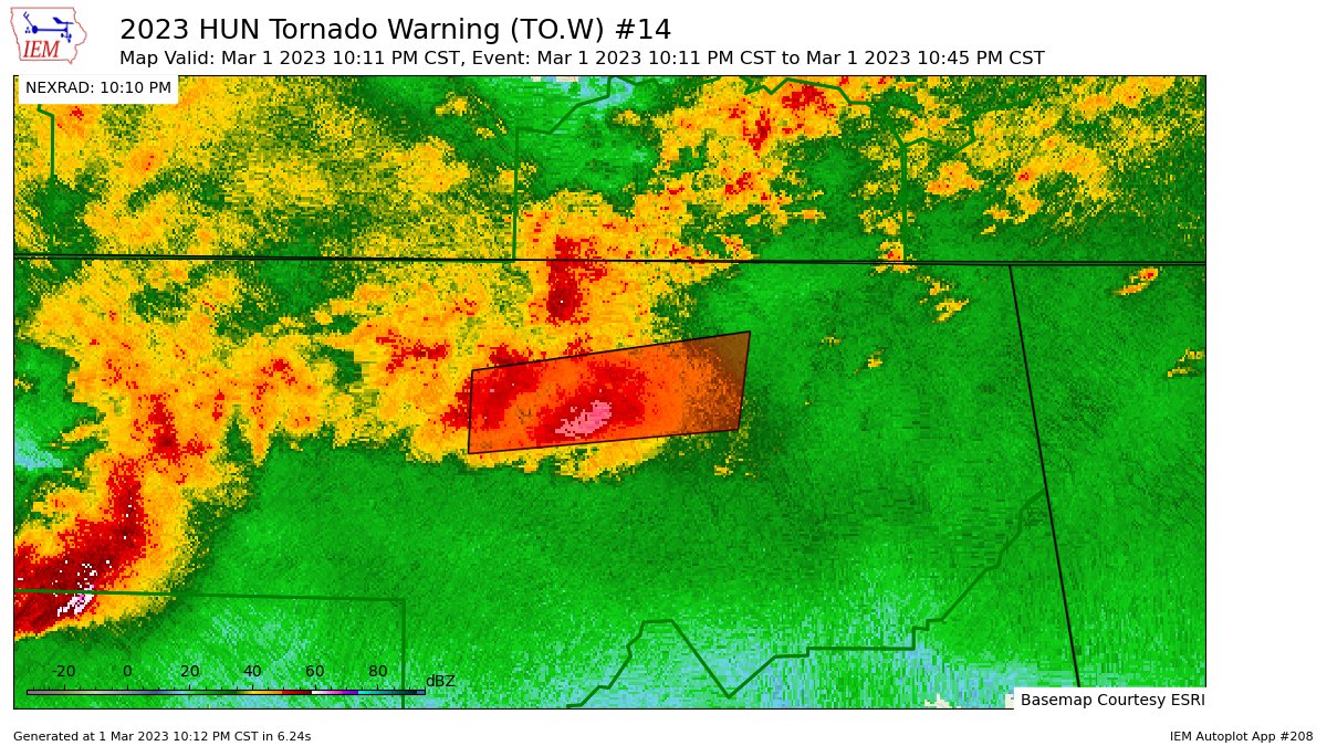
The National Weather Service in Huntsville Alabama has issued a
* Tornado Warning for...
West central Jackson County in northeastern Alabama...
Central Madison County in north central Alabama...
Southeastern Limestone County in north central Alabama...
* Until 1045 PM CST.
* At 1011 PM CST, a severe thunderstorm capable of producing a
tornado was located over Madison, moving east at 30 mph.
HAZARD...Tornado.
SOURCE...Radar indicated rotation.
IMPACT...Flying debris will be dangerous to those caught without
shelter. Mobile homes will be damaged or destroyed.
Damage to roofs, windows, and vehicles will occur. Tree
damage is likely.
* This dangerous storm will be near...
Marshall Space Flight Center around 1015 PM CST.
Redstone Arsenal and University Of Alabama In Huntsville around
1020 PM CST.
Alabama A And M University around 1030 PM CST.
Gurley around 1045 PM CST.
Other locations impacted by this tornadic thunderstorm include Paint
Rock, Maysville, Belle Mina, French Mill, Mooresville, Capshaw,
Garth, Ryland, Hampton Cove and Brownsboro.
PRECAUTIONARY/PREPAREDNESS ACTIONS...
TAKE COVER NOW! Move to a basement or an interior room on the lowest
floor of a sturdy building. Avoid windows. If you are outdoors, in a
mobile home, or in a vehicle, move to the closest substantial shelter
and protect yourself from flying debris.
&&
LAT...LON 3460 8695 3477 8694 3485 8625 3465 8628
TIME...MOT...LOC 0411Z 255DEG 25KT 3469 8672
TORNADO...RADAR INDICATED
MAX HAIL SIZE...<.75 IN
$$
KTW


No comments:
Post a Comment