

This one has a radar debris signature confirmation.
.png)
All the other tornado warnings were replaced by severe thunderstorm warnings, but still a good idea to stay in a safe place until those damaging winds pass. It is 10:43 as I write this, forgot to put time stamp...

10:44 - That debris signature did not last long and I only saw it on broadcast media. It came and went quickly, but I think there was some damage in New Market that would confirm it. Still a good idea to be sheltered for this storm even though rotation has weakened quickly. It could spin back up quickly. These storms can dissipate or they can cycle.
.png)
10:51 - Warning expires in about eight minutes. Storm not looking as bad but I'd play it safe and keep an eye on it.
10:57 - A few warnings expiring at 11 PM. As long as no new warnings come out, will make another post then at 11:00 and just kind of catch up on severe thunderstorm/flash flood warnings still in effect, and damage reports coming in here and there. Have to have priorities, and a tornado is a priority.
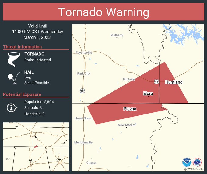
544
WFUS54 KHUN 020435
TORHUN
ALC089-TNC051-103-020500-
/O.NEW.KHUN.TO.W.0015.230302T0435Z-230302T0500Z/
BULLETIN - EAS ACTIVATION REQUESTED
Tornado Warning
National Weather Service Huntsville AL
1035 PM CST Wed Mar 1 2023
The National Weather Service in Huntsville Alabama has issued a
* Tornado Warning for...
North central Madison County in north central Alabama...
Southeastern Lincoln County in Middle Tennessee...
Southwestern Franklin County in Middle Tennessee...
* Until 1100 PM CST.
* At 1035 PM CST, a severe thunderstorm capable of producing a
tornado was located near New Market, or 7 miles northeast of
Meridianville, moving northeast at 20 mph.
HAZARD...Tornado.
SOURCE...Radar indicated rotation.
IMPACT...Flying debris will be dangerous to those caught without
shelter. Mobile homes will be damaged or destroyed.
Damage to roofs, windows, and vehicles will occur. Tree
damage is likely.
* This dangerous storm will be near...
Huntland around 1100 PM CST.
Other locations impacted by this tornadic thunderstorm include Elora
and Plevna.
PRECAUTIONARY/PREPAREDNESS ACTIONS...
TAKE COVER NOW! Move to a basement or an interior room on the lowest
floor of a sturdy building. Avoid windows. If you are outdoors, in a
mobile home, or in a vehicle, move to the closest substantial shelter
and protect yourself from flying debris.
&&
LAT...LON 3499 8622 3499 8631 3498 8631 3497 8629
3492 8653 3498 8656 3513 8630
TIME...MOT...LOC 0435Z 245DEG 17KT 3496 8649
TORNADO...RADAR INDICATED
MAX HAIL SIZE...<.75 IN
$$
KTW


No comments:
Post a Comment