

11:06 PM - Guess I will post updates here. If you are in this warning, I would still get to a good safe place, preferably in a small interior room on the lowest floor of a sturdy house.
.png)
11:08 - But mainly what we have been getting now are flash flood warnings. For Madison, Limestone, Lincoln (TN), Colbert, Franklin (AL), and Lawrence counties. Especially in places like Athens and Huntsville, the flooding is described in the text of the warning as being life-threatening and a considerable threat. Most flood deaths happen in vehicles, so if you come to water that covers the road, turn around, and don't drown. More people die from driving into flood waters than from tornadoes or lightning anyway.

11:12 - The tornado watch has been cleared for Lauderdale, Colbert, and Franklin counties as the severe weather threat has ended. The watch is supposed to expire for the rest of us at 2 AM. It may be cancelled before then, we'll see.
Also saw from Jason Simpson that Northern Marion County did have some damage from the tornado warning earlier, lots of trees and power lines down, think it was mainly near Shotsville. If I remember correctly, emergency management was asking people to stay out of there. They are trying to get things cleaned up and make sure everybody's ok...
I knew some people in a tornado warning earlier that I still have not heard back from, thinking their power or cell service was just knocked out since no injury reports from media or social media, but still an unpleasant sense of suspense waiting to hear about it. Circulation was coming right at them at one point.

11:25 PM - All right, looks like RadarScope is doing better for the moment, still not showing the flood warnings, but they have been struggling with that issue for days. Glad they are out there providing services at all, and wish them the best in getting things resolved.

11:27 - Definitely seeing evidence of strong winds in Jackson County, which is why the severe thunderstorm warning was issued. Rotation is broad, and there probably is not a tornado trying to form there. But the severe winds can be dangerous by themselves.
11:30 - And they have let this warning expire on time. So the high winds there are no longer thought to be at severe limits.
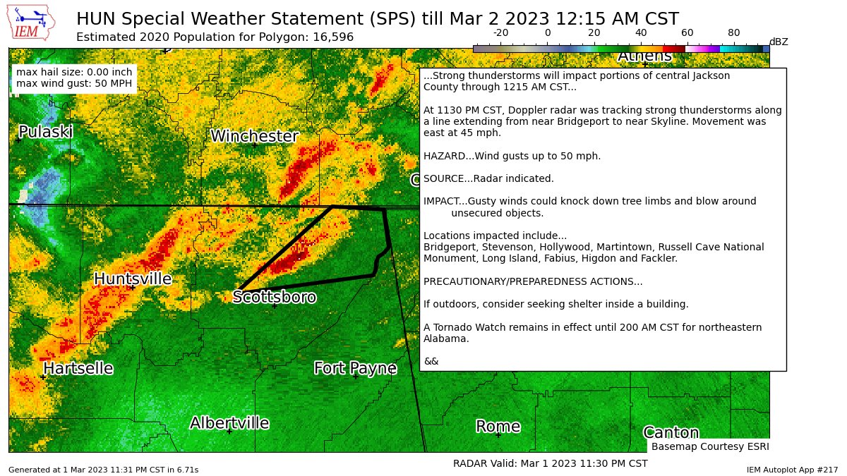
11:32 - All right, here is a special weather statement about what is still going on in Jackson County. From what I'm seeing, there was another tornado damage area, think it was the thing that spun up near New Market. So we've got that and the one in Marion County, they will have to survey tomorrow I guess, when hopefully there is a break in the action before Friday morning's severe weather threat. Those two areas, it sounds to me like a tornado was confirmed because of the debris signatures on radar and there being damage. The one in I think Limestone County had the roof taken off a house. I saw it on Brad Travis's stream. I bounce around TV stations while watching stuff online sometimes.
11:38 - In Hazel Green in Madison County they are reporting, emergency management, some poles snapped, possibly by a tornado. That is estimated to have happened a little over an hour ago, about 10:33 PM.
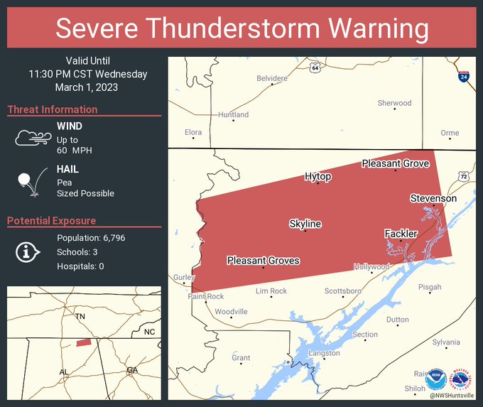
11:41 -
591
WUUS54 KHUN 020500
SVRHUN
ALC071-020530-
/O.NEW.KHUN.SV.W.0032.230302T0500Z-230302T0530Z/
BULLETIN - IMMEDIATE BROADCAST REQUESTED
Severe Thunderstorm Warning
National Weather Service Huntsville AL
1100 PM CST Wed Mar 1 2023
The National Weather Service in Huntsville Alabama has issued a
* Severe Thunderstorm Warning for...
Northwestern Jackson County in northeastern Alabama...
* Until 1130 PM CST.
* At 1100 PM CST, a severe thunderstorm was located 8 miles west of
Skyline, or 15 miles east of Moores Mill, moving east at 35 mph.
HAZARD...60 mph wind gusts.
SOURCE...Radar indicated.
IMPACT...Expect damage to roofs, siding, and trees.
* Locations impacted include...
Stevenson, Hollywood, Skyline, Gurley, Pleasant Groves, Hytop,
Bass, Martintown, Princeton and Estillfork.
PRECAUTIONARY/PREPAREDNESS ACTIONS...
For your protection move to an interior room on the lowest floor of a
building.
A Tornado Watch remains in effect until 200 AM CST for north central
and northeastern Alabama...and Middle Tennessee.
&&
LAT...LON 3468 8636 3473 8636 3474 8634 3479 8634
3479 8633 3481 8635 3483 8633 3486 8635
3488 8635 3499 8588 3499 8584 3476 8580
TIME...MOT...LOC 0500Z 259DEG 30KT 3480 8626
HAIL THREAT...RADAR INDICATED
MAX HAIL SIZE...<.75 IN
WIND THREAT...RADAR INDICATED
MAX WIND GUST...60 MPH
$$
KTW


No comments:
Post a Comment