

.png)
.png)
11:50 PM - This does include the city of Cullman and includes West Point. In in the path of this, I would get to a small central room on the lowest floor of your home, and it is better if you can be in a sturdy house or other building, not a mobile home. There is weak rotation and a low chance of a tornado developing in this storm. Although it is more likely to have damaging straight-line wind gusts with this storm.
Sorry about all the technology glitches tonight.
11:54 - Vinemont, Fairview, Holly Pond, areas along that path, also a good idea to be sheltered as a course of least regret.

11:58 - Folks near Arab or Boaz also want to monitor the progress of this storm in case it remains severe by the time it gets there. It is moving due East for now.
MIDNIGHT - Nevermind. The storm weakened rapidly, and the warning was cancelled. The air is stabler as you get into Northeast Alabama anyway.
Some storms are tricky like that. They can produce some high winds or even a tornado and then weaken quickly in a marginal environment like we have now.
12:03 AM - All right, the tornado watch has been cancelled for all of our counties except Cullman, Marshall, Dekalb, Madison, Jackson, Morgan, Winston, Walker, Fayette, Lamar, and Marion. I think Marion County, TN and areas East of there are still under a tornado watch. That's really out of the area I watch even when on my A-game. Franklin County TN has been cleared from the watch, it just has not shown up on the map yet.
.png)
The tornado watch goes until 2 AM unless the other counties get cancelled before then. The storms have formed into a line, and there has been a lot of heavy rain. The atmosphere is marginal for anything else going severe tonight. But as long as that tornado watch is in effect, I respect it, because I've seen too many times, you don't give the all clear until you're sure.
12:08 - Marion, Hamilton, and Sequatchie counties up in Tennessee just went under a severe thunderstorm warning, with mention that a tornado could develop quickly from it. Since I just mentioned them. Like I said, that is on the fringes. That warning does include the city of Chattanooga though.
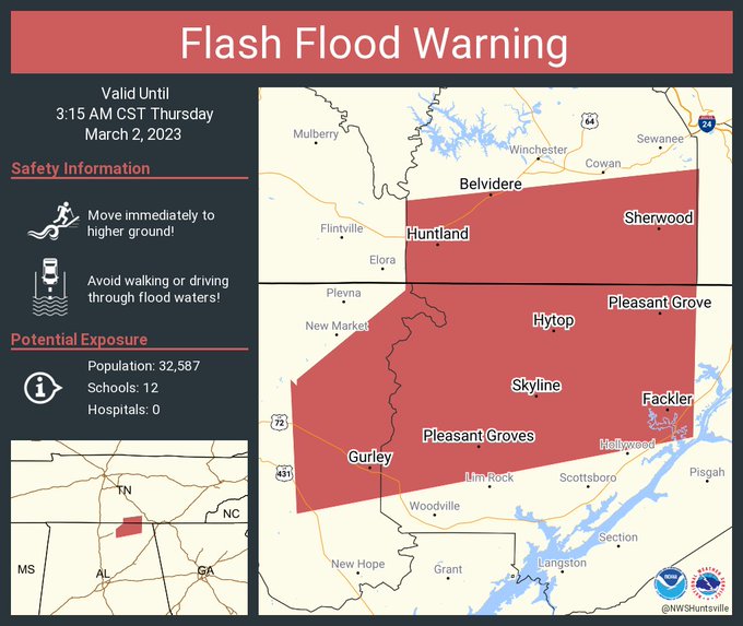
Just got a new flash flood warning also for eastern Madison, Jackson, and southern Lincoln counties.
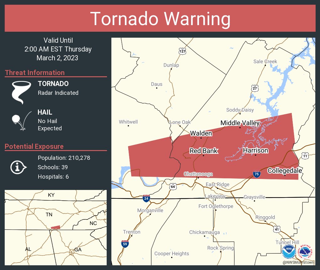
12:13 - And that thing in Marion County, TN was upgraded to a tornado warning.
12:20 - Back on the Alabama side, Marion and Winston counties have been cleared from the tornado watch as the severe weather threat there is over. The threat is pretty low, but the watch expires in about an hour and a half. And we just had that possible tornado spin up across on the Tennessee side, warning includes Chattanooga.
While things are winding down here, today (meaning Thursday now) may be a tornado outbreak for the mid-South.

And I don't know how to get the text above to left-align again. Sorry about all the technology glitches tonight, but it does not look like I've had a lot of readers either. Radarscope has often been worthless, and I just bought it today, first time I ever had it on an actual computer.
Anyway the storms should have formed into a squall line late in the period, very late tomorrow night into wee hours of Friday morning. And you see that Northwest Alabama does have some chance for isolated tornadoes. Based on what happened this evening and tonight, I am not eager to blow off even a marginal threat for tornadoes or wind damage. We did have damage in Northern Marion County and I believe more significant damage near New Market, also some poles broken by winds at Hazel Green from when a tornado warning was in effect. Hope I am getting all of this right, if not I will try to correc them later, but that is what I remember reading or seeing from broadcast media. I think my loved ones are probably okay, as in no injury, but still, I think the storms knocked out their power and cell service, since have not heard from them. That has made posting updates a bit more challenging tonight.
Be right back . . .
All right. I guess I will do a radar update and then at 1 AM will post the new outlook for the squall line hitting us Friday morning. It is 12:49 AM now and I still have not heard from the people I know who were in the path of one of the tornado warnings. There may be power and cell outages that we don't know about at night. It is so hard to confirm tornadoes or wind damage in the dark hours even with all this awesome technology like dual-pol radar.

12:53 - All right, so now we are down to flash flood warnings in North Alabama. And these storms are behaving a lot better, although some are producing a good bit of lightning, of course heavy rain, and gusty winds. They are all staying below severe limits for now.
The tornado watch does remain in effect for Lamar, Fayette, Walker, Cullman, Marshall, Dekalb, and Jackson counties until 2 AM.
12:58 - And the tornado watch has been cancelled. This has become a flash flooding concern. Of course any rain and storms we get Thursday night into Friday morning may aggravate existing flood concerns.
.png)
1:01 AM - Double checking accuracy here . . . the National Weather Service in Birmingham is keeping the watch alive for Walker, Fayette, and Lamar counties until 2 AM. The counties that were cancelled were covered by Huntsville.

1:07 - And we have the new outlook for Friday morning. That squall line will be ongoing and moving into Alabama probably close to daybreak. From about 4 AM to Noon is a good broad time window for when it is most likely to move through the area. Actually the local offices made some maps with the timing so let's look at those if I can grab them right quick . . .
Omitting the Nashville office because the only thing available from them is from much earlier on Wednesday and would just be a confusing mess to post here, was only able to find it on their social media anyway...but if you're in Tennessee you can basically figure it out based on these maps...


564
WUUS54 KHUN 020541
SVRHUN
ALC043-020615-
/O.NEW.KHUN.SV.W.0033.230302T0541Z-230302T0615Z/
BULLETIN - IMMEDIATE BROADCAST REQUESTED
Severe Thunderstorm Warning
National Weather Service Huntsville AL
1141 PM CST Wed Mar 1 2023
The National Weather Service in Huntsville Alabama has issued a
* Severe Thunderstorm Warning for...
Northern Cullman County in north central Alabama...
* Until 1215 AM CST.
* At 1141 PM CST, a severe thunderstorm was located over Sardis, or 9
miles northeast of Arley, moving east at 50 mph.
HAZARD...60 mph wind gusts.
SOURCE...Radar indicated.
IMPACT...Expect damage to roofs, siding, and trees.
* Locations impacted include...
Cullman, Good Hope, Holly Pond, Baldwin, Vinemont, Baileyton, West
Point, Eva and Jones Chapel.
PRECAUTIONARY/PREPAREDNESS ACTIONS...
For your protection move to an interior room on the lowest floor of a
building.
A Tornado Watch remains in effect until 200 AM CST for north central
and northeastern Alabama.
&&
LAT...LON 3415 8711 3428 8711 3431 8678 3431 8665
3415 8659 3414 8659 3413 8660
TIME...MOT...LOC 0541Z 262DEG 43KT 3421 8712
TORNADO...POSSIBLE
HAIL THREAT...RADAR INDICATED
MAX HAIL SIZE...<.75 IN
WIND THREAT...RADAR INDICATED
MAX WIND GUST...60 MPH
$$
KTW


No comments:
Post a Comment