


12:05 AM - Also a wind gust of 59 mph at Haleyville Airport, straight-line winds from that long-tracked storm that produced a tornado earlier but now is absorbed in squall line. As you can see from this storm affecting Fayetteville, we are not out of the woods yet tonight. Not until the squall line has completely cleared your area. Some storms in this line can rotate, and produce a tornado. The potential is still there.
And the damaging straight-line winds can be dangerous too. Many severe thunderstorm warnings along this line of storms.
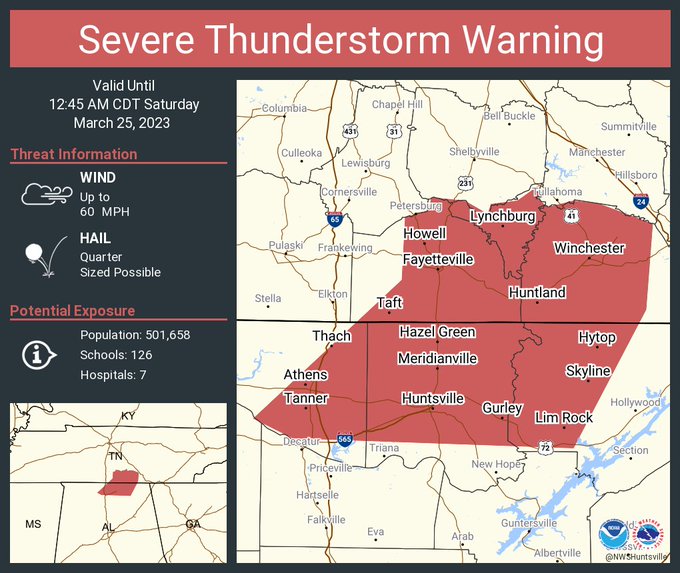
12:08 - Huntsville now included in a new severe thunderstorm warning. Basically all of Lawrence and Winston Counties are under a severe thunderstorm warning.

12:11 - Lymchburg, Booneville, Mulberry, Kelso, Beach Hill, please stay sheltered until this possible tornado passes.
Because it has been such a rough night for a lot of people, trying to give priority to any tornado warnings. The severe thunderstorm winds along the squall line are still dangerous. And the environment does favor tornadoes being able to spin up quickly. So it certainly would not hurt to take shelter from the severe thunderstorm warnings too. But because of the kind of night it has been, even though this is up on the Tennessee line, our bordering counties, giving it priority for the moment since a tornado may be here.

12:16 - Severe thunderstorm warning including Decatur now. These straight-line winds are still dangerous. Would be wise to be in a good safe place while they move through to be on the safe side. And tornadoes can still spin up quickly within this squall line.
12:20 - Colbert, Lauderdale, and Franklin Counties have been cleared from the tornado watch. Continues until 3 AM for the rest of us.
Well actually some of the Tennessee counties like Wayne and Lawrence have been cleared too. They are cancelling it out behind the squall line as we would expect.
861
WFUS54 KHUN 250458
TORHUN
TNC051-103-127-250530-
/O.NEW.KHUN.TO.W.0023.230325T0458Z-230325T0530Z/
BULLETIN - EAS ACTIVATION REQUESTED
Tornado Warning
National Weather Service Huntsville AL
1158 PM CDT Fri Mar 24 2023
The National Weather Service in Huntsville Alabama has issued a
* Tornado Warning for...
Moore County in Middle Tennessee...
Central Lincoln County in Middle Tennessee...
Northwestern Franklin County in Middle Tennessee...
* Until 1230 AM CDT.
* At 1158 PM CDT, a severe thunderstorm capable of producing a
tornado was located over Fayetteville, moving east at 50 mph.
HAZARD...Tornado.
SOURCE...Radar indicated rotation.
IMPACT...Flying debris will be dangerous to those caught without
shelter. Mobile homes will be damaged or destroyed.
Damage to roofs, windows, and vehicles will occur. Tree
damage is likely.
* This dangerous storm will be near...
Lynchburg around 1215 AM CDT.
Tims Ford Lake around 1230 AM CDT.
Other locations impacted by this tornadic thunderstorm include Lexie
Crossroads, Mulberry, Howell, Harmony, Hurdlow, Lois, Mimosa,
Booneville, Marble Hill and Skinem.
PRECAUTIONARY/PREPAREDNESS ACTIONS...
TAKE COVER NOW! Move to a basement or an interior room on the lowest
floor of a sturdy building. Avoid windows. If you are outdoors, in a
mobile home, or in a vehicle, move to the closest substantial shelter
and protect yourself from flying debris.
&&
LAT...LON 3515 8617 3504 8666 3517 8673 3533 8645
3532 8642 3533 8641 3535 8641 3535 8637
3536 8636 3536 8633 3538 8633 3539 8629
TIME...MOT...LOC 0458Z 249DEG 42KT 3513 8662
TORNADO...RADAR INDICATED
MAX HAIL SIZE...<.75 IN


No comments:
Post a Comment