

9:35 PM - This is a long-lived storm that has tried to cycle up several times and produce a tornado.


Everyone in that path, especially in cities of Decatur, Madison, and Huntsville, please take this storm seriously. Do not stay in a mobile home, don't be out driving, get into a sturdy house or other building - small room, lowest floor, center part of house, away from any windows - and if you can, grab something to cover your body, especially protect your head and your neck. If you know somebody who might be sleeping through this, please call them and let them know. This storm is concerning, and tornadoes are tough to confirm at night.

9:39 - We are getting a hook echo. This may be on the ground, and it could produce significant damage, especially considering that it is heading toward some populated areas. Very dangerous at night. Please let people know, and if you are in path, get to a safe place right now. Try to cover your head, or if in a basement, try to get up under something sturdy like a table or stairs if it is feasible, take some extra precautions if you can in case of falling or flying debris. Mainly if you can protect your head, even with something like a pillow if you do not have a safety helmet, that is a good idea with this storm.
.png)
.png)

9:47 - As Brad Travis and James Spann have been noting, the structure of this storm keeps improving. That is a classic hook echo and a pretty good velocity couplet. Assume this tornado is already on the ground and don't wait for it to be confirmed, take cover.
.png)
9:51 - Got a couple severe thunderstorm warnings now, one for a bow echo moving into Colbert and FRanklin counties in Northwest Alabama. Also got one for northern Madison and Limestone counties and clipping the Tennessee border, some spots up there, tiny parts of a couple of the TN counties. Even in those areas, you might want to get to a good safe place. But of course the main focus will be on this possible tornado. It is not confirmed yet, but it is hard to confirm them at night. If it is on the ground, it could be fairly damaging, the way it looks on radar and the way the atmosphere is tonight.
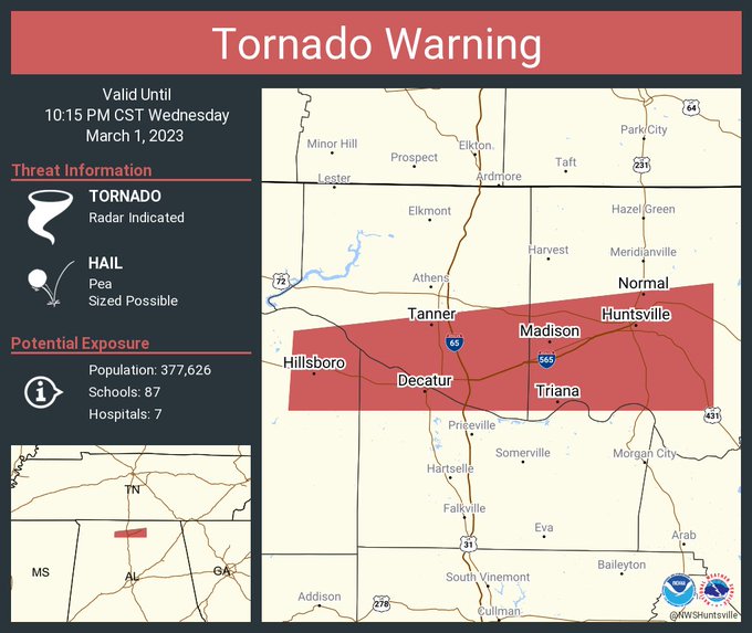
025
WFUS54 KHUN 020327
TORHUN
ALC079-083-089-103-020415-
/O.NEW.KHUN.TO.W.0012.230302T0327Z-230302T0415Z/
BULLETIN - EAS ACTIVATION REQUESTED
Tornado Warning
National Weather Service Huntsville AL
927 PM CST Wed Mar 1 2023
The National Weather Service in Huntsville Alabama has issued a
* Tornado Warning for...
Southwestern Madison County in north central Alabama...
Southeastern Limestone County in north central Alabama...
Northern Morgan County in north central Alabama...
Northeastern Lawrence County in northwestern Alabama...
* Until 1015 PM CST.
* At 927 PM CST, a severe thunderstorm capable of producing a tornado
was located near Trinity, or 8 miles northwest of Decatur, moving
east at 50 mph.
HAZARD...Tornado.
SOURCE...Radar indicated rotation.
IMPACT...Flying debris will be dangerous to those caught without
shelter. Mobile homes will be damaged or destroyed.
Damage to roofs, windows, and vehicles will occur. Tree
damage is likely.
* This dangerous storm will be near...
Decatur around 930 PM CST.
Tanner around 940 PM CST.
Huntsville International Airport around 950 PM CST.
Madison and Triana around 955 PM CST.
Redstone Arsenal, Marshall Space Flight Center and University Of
Alabama In Huntsville around 1000 PM CST.
Alabama A And M University around 1005 PM CST.
Owens Cross Roads around 1010 PM CST.
Other locations impacted by this tornadic thunderstorm include Belle
Mina, Hillsboro, Farley, Mooresville, Ryland, Hampton Cove,
Whitesburg, Brownsboro and Caddo.
PRECAUTIONARY/PREPAREDNESS ACTIONS...
TAKE COVER NOW! Move to a basement or an interior room on the lowest
floor of a sturdy building. Avoid windows. If you are outdoors, in a
mobile home, or in a vehicle, move to the closest substantial shelter
and protect yourself from flying debris.
&&
LAT...LON 3457 8724 3472 8723 3481 8644 3457 8644
TIME...MOT...LOC 0327Z 264DEG 43KT 3464 8713
TORNADO...RADAR INDICATED
MAX HAIL SIZE...<.75 IN
$$
KTW


No comments:
Post a Comment