


So we've already got Lauderdale and Colbert counties under a warning. We will see how things develop over about the next six hours.
.png)
7:50 PM - These storms are supercells. The warning data is messing up and Radarscope is trying to resolve it so may be mostly relying on regular NWS radar a lot tonight. Lightning not showing up well on radarscope anymore either, NWS source does not show that. May be a little bit of a crazy night.

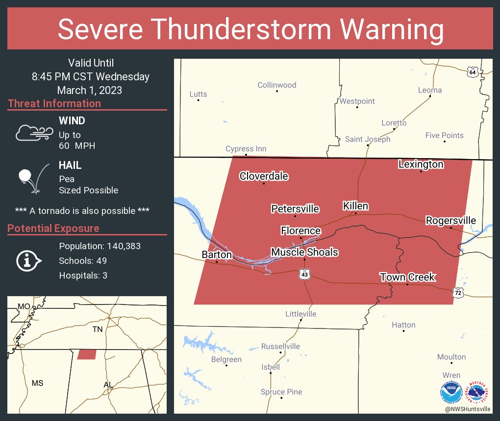
7:54 - And now a tornado warning until 8:30 that includes Florence and Muscle Shoals I believe. National Weather Service in Memphis had a report of a wall cloud with this.
Circled the two possible tornadoes back in Mississippi, weak circle around some weak rotation up near Waynesboro. Don't think there is a warning up there but will double check. Still learning a new computer so updates may not be as prompt as would like. Notice they are giving plenty of lead time ahead of these supercell thunderstorms that are trying to produce tornadoes.
Use that time if in the path to get to a safe place - small interior (central) room or hallway on the lowest floor of a sturdy house or other strong building - not trying to shelter in a mobile home. Might want to cover your head with something and/or shield body in case of flying debris. Be in that center lowest room away from any windows...

Here is the wide view as far as warnings.

Muscle Shoals is included in one of the new warnings. Belmont about to get hit by this storm.
.png)

Here is a better look at the warning polygons.
8:09 PM - Now you can see a lot of lightning around those two circulations, where the red and green colors come together in sharp contrast, that is rotating winds. Either tornadoes or storms trying to produce tornadoes. And these are supercellular, out by themselves, with enough fuel and wind energy to work with.

8:11 - Well they have started to merge into more of a cluster, but for a while there they were isolated cells. Still look fairly dangerous.
This first system may be overperforming. From this point on just going to watch it and see what develops.
8:24 - Severe thunderstorm warning extended eastward with a note that a tornado is possible along with the damaging straight-line winds.


8:26 - Still seeing rotation as well. I advise being in a small central room on the lowest floor, away from windows, whether you are in the tornado or severe thunderstorm warning areas.
8:29 - So we have severe thunderstorm warnings for Lauderdale, Colbert, and northern Lawrence County. And a tornado warning remains in effect for Franklin County Alabama.
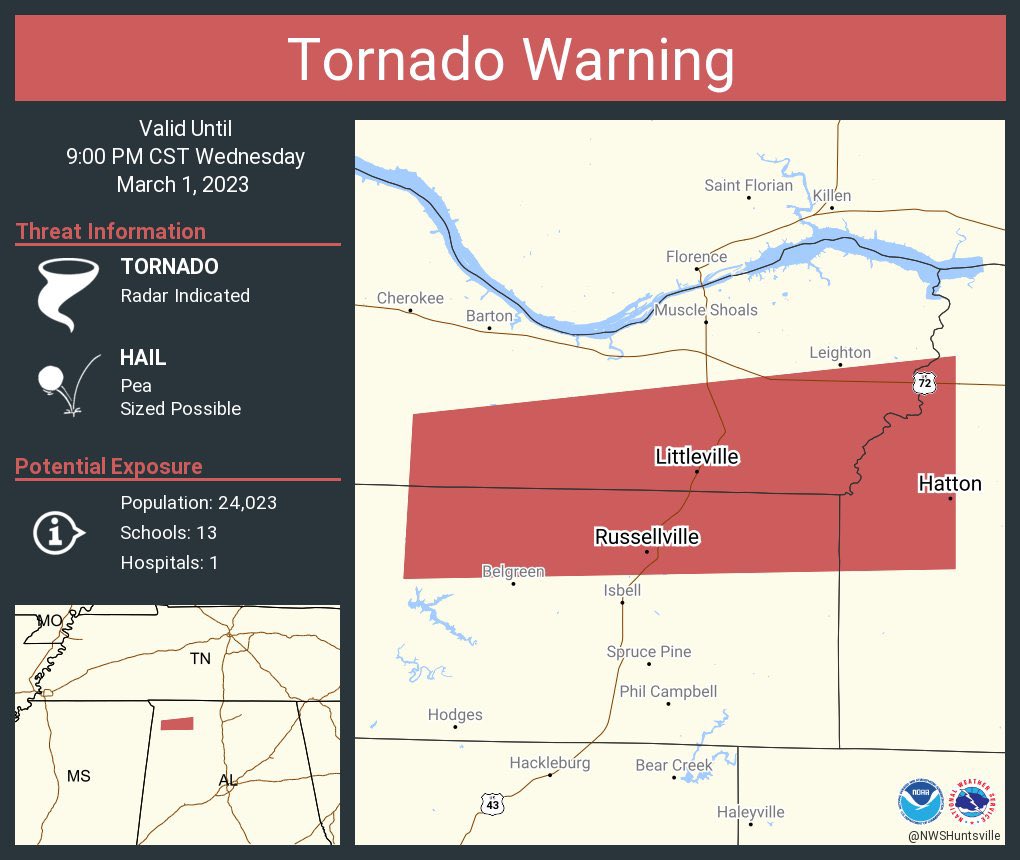
8:31 - Looks like they just extended the tornado warning to include part of Lawrence County, up to the community of Hatton.
.png)
8:36 - I'd be sheltered in either of these warning polygons, treat it like a tornado to be on the safe side. It is dark.
8:37 - That possible tornado, southern storm, is moving from Russellville in the direction of Littleville and then Town Creek. Either one of those places or communities near there within that polygon, I'd get to your shelter - small central room on the lowest floor of a sturdy house - not a mobile home.

8:48 - The rotations, current positions. Looks like the tornado warning will be allowed to expire at 9 PM. The rotation is not as strong, but I would still stay sheltered, even if this only ends up producing damaging thunderstorm winds.

8:51 - A supercell storm from Arkansas is being closely watched in case it tries to put down a tornado soon. The atmosphere is right, especially back that way, to support a tornado that stays down a while and does significant damage.

8:57 - New severe thunderstorm warning coming out until 9:30 including Lawrence, Morgan, and Limestone counties.
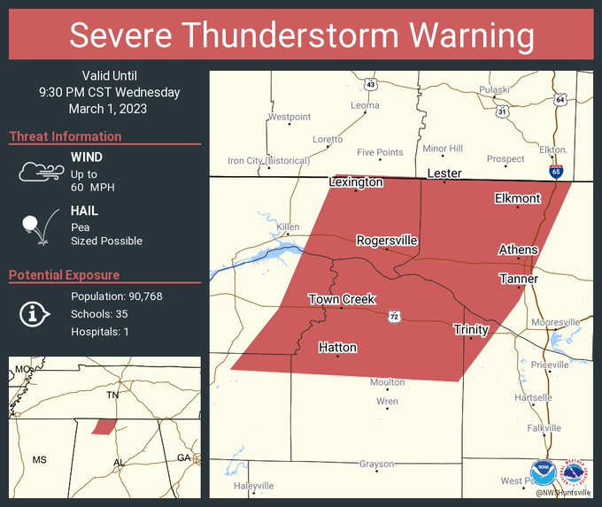
8:59 - There is that new warning polygon.

9:07 PM - That storm moving through Dumas moving from Arkansas across into Mississippi is the one that is really being watched as potentially a long-track supercell, could end up producing a tornado.

9:18 - Definitely seeing some evidence of strong, perhaps damaging winds north of Moulton there. This area remains under a severe thunderstorm warning. The environment also favors where a tornado could develop quickly in a severe thunderstorm like this. Either way, good to be in a safe place if in the path
9:27 - Think I will start a new post for next severe thunderstorm warning as the storm seems to be ramping back up.
SEL1
URGENT - IMMEDIATE BROADCAST REQUESTED
Tornado Watch Number 51
NWS Storm Prediction Center Norman OK
735 PM CST Wed Mar 1 2023
The NWS Storm Prediction Center has issued a
* Tornado Watch for portions of
Northern Alabama
Southern Middle Tennessee
* Effective this Wednesday night and Thursday morning from 735 PM
until 200 AM CST.
* Primary threats include...
A few tornadoes and a couple intense tornadoes possible
Scattered damaging wind gusts to 70 mph possible
Isolated large hail events to 1.5 inches in diameter possible
SUMMARY...Severe weather/tornado potential is expected to steadily
increase through mid into late-evening as low/mid-level winds
strengthen and storms develop and move into the region.
The tornado watch area is approximately along and 60 statute miles
north and south of a line from 30 miles southwest of Muscle Shoals
AL to 45 miles east northeast of Huntsville AL. For a complete
depiction of the watch see the associated watch outline update
(WOUS64 KWNS WOU1).
PRECAUTIONARY/PREPAREDNESS ACTIONS...
REMEMBER...A Tornado Watch means conditions are favorable for
tornadoes and severe thunderstorms in and close to the watch
area. Persons in these areas should be on the lookout for
threatening weather conditions and listen for later statements
and possible warnings.
&&
OTHER WATCH INFORMATION...CONTINUE...WW 50...
AVIATION...Tornadoes and a few severe thunderstorms with hail
surface and aloft to 1.5 inches. Extreme turbulence and surface wind
gusts to 60 knots. A few cumulonimbi with maximum tops to 500. Mean
storm motion vector 24040.
...Guyer


No comments:
Post a Comment