So as I get a new computer system set up (old one died after 4-5 years of being a trusty scout), I see that the weather is already starting to get a little active in these parts.
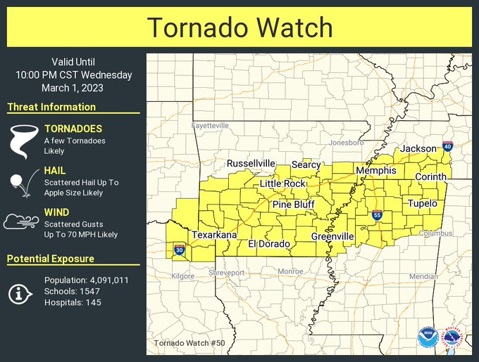
The Storm Prediction Center is getting ready to issue a tornado watch for much of Arkansas, through Memphis and Northern Mississippi, and perhaps even including places like the Shoals.
3:37 PM - All right, so the tornado watch has come out. The only area near here it includes is Hardin County, Tennessee. Usually I'm not going to notice it and post updates until something gets as far East as Wayne County, TN. The core of this watch is back in Mississippi and Arkansas.
We do have a low-end threat for severe storms this evening in the Tennessee Valley though. And that risk will last to some extent until our main event very late Thursday night/Friday morning, which looks like it will be a really strong squall line, potential for widespread damaging winds, but also a risk for a few embedded tornadoes in the line. Need to have weather radio on alert and/or phone alerts enabled for the next few days. If you normally wouldn't...important time to just in case you fall under a warning polygon.
ARKANSAS COUNTIES INCLUDED ARE
ARKANSAS ASHLEY BRADLEY
CALHOUN CHICOT CLARK
CLEVELAND COLUMBIA CRITTENDEN
CROSS DALLAS DESHA
DREW FAULKNER GARLAND
GRANT HEMPSTEAD HOT SPRING
HOWARD JEFFERSON LAFAYETTE
LEE LINCOLN LITTLE RIVER
LONOKE MILLER MONROE
MONTGOMERY NEVADA OUACHITA
PERRY PHILLIPS PIKE
POLK PRAIRIE PULASKI
SALINE SCOTT SEVIER
ST. FRANCIS UNION WHITE
WOODRUFF YELL
MSC003-009-011-013-015-017-025-027-033-043-057-071-081-083-093-
095-097-107-115-117-119-133-135-137-139-141-143-145-151-155-161-
020400-
/O.NEW.KWNS.TO.A.0050.230301T2130Z-230302T0400Z/
MS
. MISSISSIPPI COUNTIES INCLUDED ARE
ALCORN BENTON BOLIVAR
CALHOUN CARROLL CHICKASAW
CLAY COAHOMA DESOTO
GRENADA ITAWAMBA LAFAYETTE
LEE LEFLORE MARSHALL
MONROE MONTGOMERY PANOLA
PONTOTOC PRENTISS QUITMAN
SUNFLOWER TALLAHATCHIE TATE
TIPPAH TISHOMINGO TUNICA
UNION WASHINGTON WEBSTER
YALOBUSHA
OKC089-020400-
/O.NEW.KWNS.TO.A.0050.230301T2130Z-230302T0400Z/
OK
. OKLAHOMA COUNTIES INCLUDED ARE
MCCURTAIN
TNC023-039-047-069-071-075-077-109-113-157-167-020400-
/O.NEW.KWNS.TO.A.0050.230301T2130Z-230302T0400Z/
TN
. TENNESSEE COUNTIES INCLUDED ARE
CHESTER DECATUR FAYETTE
HARDEMAN HARDIN HAYWOOD
HENDERSON MADISON MCNAIRY
SHELBY TIPTON
TXC037-063-067-159-343-387-449-020400-
/O.NEW.KWNS.TO.A.0050.230301T2130Z-230302T0400Z/
TX
. TEXAS COUNTIES INCLUDED ARE
BOWIE CAMP CASS
FRANKLIN MORRIS RED RIVER
TITUS
ATTN...WFO...LZK...SHV...MEG...JAN...
So there is the watch outline out that way. I am still trying to learn Radarscope on a computer, first time I've had that. Before only had it on a phone and had to e-mail it to myself to get the image and put on a computer. So if you're reading this, please bear with me as I learn to do things again in a slightly different style.
These thunderstorms in and close to the watch area are thought to be capable of winds up to 70 mph, hail up to 3 inches in diameter, and a few tornadoes. This could cause someone fairly substantial damage if a storm really ramps up.
4:07 PM - So let's review the weather hazards around here:
First off, we have a risk of flash flooding problems tonight through Friday. Most of the rain should come tonight. Remember if you see water covering a road the old slogan - "Turn around, don't drown."
We're going to have gusty winds even outside of thunderstorms tomorrow night into Friday.
A few isolated storms tonight could still reach severe limits around here. As with any overnight severe weather threat, you need a NOAA Weather Radio set properly with battery backup.
The main squall line event still looks like it will be Friday morning. It is looking more likely for Friday morning than for anything tomorrow night.
In fact the Storm Prediction Center has trimmed us mostly out of the severe weather risk for tomorrow/tomorrow night. Could be a tornado outbreak for people in Southern Arkansas, Northeast Texas, Southeast Oklahoma, Northern Louisiana, Northwest and West-Central Mississippi.


But you can see where the risk extends to us Friday morning, a basic risk for what will probably be a squall line of severe thunderstorms capable of mainly damaging thunderstorm winds, but also of a few embedded tornadoes. This looks like it may be a particularly strong squall line. And even if all you get is a severe thunderstorm warning, you need to take it seriously. I think WEA on phones has started pushing the particularly dangerous severe thunderstorm warnings sometimes, like if the winds are expected to be over 80 mph, but I'd have to double check that to make sure. A weather radio or a service like WeatherCall will serve you well. Make sure to have fresh batteries in a weather radio Thursday night/Friday morning though, because these winds will probably cause power outages in some places as the line comes through. It is looking like it will come through on Friday morning rather than Thursday night.
As for tonight . . . this evening through the night . ..
We will have to keep an eye on things. Already tonight I'd say go to bed with your weather radio set to alert if need be. Or if using your phone, make sure it is charged and in a mode where it will ring or otherwise alert you if a warning is required. Because we do have a basic threat for damaging thunderstorm winds, a marginal threat for large hail, and a basic threat for isolated tornadoes in North Alabama and Southern Middle Tennessee this evening and tonight.
I know it is a lot of information, and that's why I'm only hitting the high points and trying to make it clear instead of delving into a lot of scientific jargon. Also I am still learning a new computer. Or it's new to me, actually refurbished, rather old model. It looks like it will get the job done.
Remember that if you get a severe thunderstorm or tornado warning, you need to get into a small central room on the lowest floor of a sturdy house or other strong building. If you're in a mobile home, you need to plan ahead to get to a sturdier shelter before a severe storm gets to you, because while they are great to live in, trailers are very susceptible to the winds of a tornado or even a severe thunderstorm that does not end up producing a tornado. Sometimes they end up completely destroyed. And it's a case where you have to put safety first and worry about any property damage later. Wherever you're going to shelter, it's best to be able to get there within five minutes of getting the warning.
4:36 - And now I'm going to see if a radar image from radarscope will post easily here . . .
And yes it does. Notice clusters of showers and a few storms getting going within Arkansas within the tornado watch. One storm went severe earlier, but at the moment, all are under severe limits.
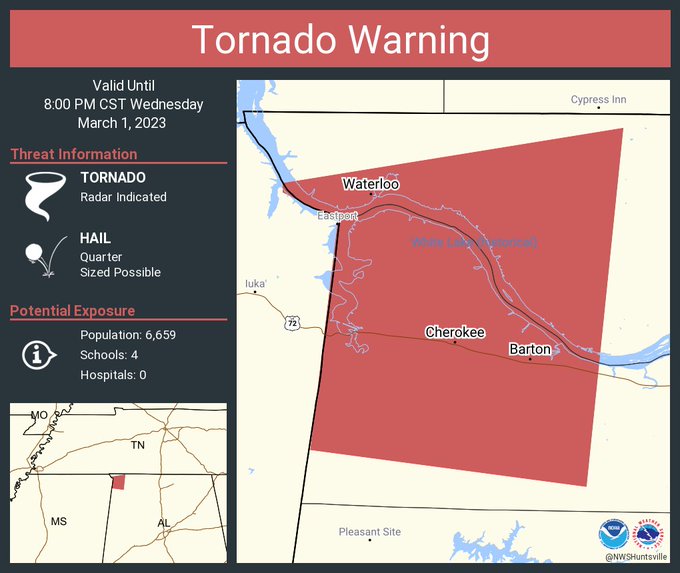
7:33 PM - Folks in Northwest Alabama really want to watch this storm showing rotation, a possible tornado, back across the MS state line.
7:35 - And the storm was just extended into Alabama.
We also just got a tornado watch. Goes until 2 AM I believe.


.png)


No comments:
Post a Comment