Right now only a small part of this squall line is severe up in Kentucky. But as we get some daylight, that may change.
The high winds are dangerous in themselves today, apart from any rain or storms. If you live in a mobile home, it is probably better to spend the day with a friend who has a sturdy house, especially if you have trees around it.
The threat for some storms to go severe and produce damaging winds, some hail, and isolated tornadoes is real too. Whether you get a severe thunderstorm warning or a tornado warning as this squall line moves through, you need to get into a small central room (bathroom, closet, or hallway) on the lowest floor of a sturdy house that is not a mobile home. And you might cover your head and neck or otherwise shield your body in case of falling or flying debris. If you do not have a safety helmet, then you might have time to grab a pillow and/or some blankets.
Don't overthink it today though, just do the basics, because these storms are going to move really fast, maybe at speeds of about 60 miles per hour. And it may be tough to tell what is straight line wind damage and tornado damage until afterward when surveys are done of whatever areas get damage.
Some of the damage will likely be from just the gradient winds outside of storms with this strong low pressure system. This is a very unusual setup, and the closest thing I know to compare it to is a hurricane moving inland, the kind of strong winds and low-end tornado threat it produces as it is dying out over land.
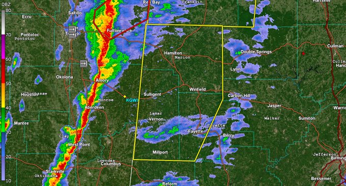
That Winfield transmitter is Channel 6 that covers Marion, Lamar, Winston, Walker, and Fayette counties, best I remember.
7:22 AM - Right now the hot zone to watch is North Central Mississippi. Some storms are gradually intensifying there ahead of the main line. The main threat is damaging winds with any storms, but of course, there is also a threat for a tornado to develop, or this would only be a severe thunderstorm watch.
7:39 - The storms sure are racing along as expected even if the line itself sort of slowed down on us. Storms within the line are moving quickly northeast. At the moment they are still under severe limits.
7:57 - Line of storms has crossed I-55 in MS and is starting to organize a little better but for now storms remain under severe limits. Should cross state line into AL within next hour or so.
8:03 AM - Via latest SPC outlook, we all have a basic damaging wind/isolated tornado threat with this system, but the hatched areas up across the Tennessee border are the most likely places for winds of hurricane force in a storm, or of a tornado developing that can really sustain itself and maybe do a little more than the average damage. So if you are on the TN side maybe be a little extra careful today, but really we all just need a safety plan and to put it into action right away if under a severe thunderstorm or tornado warning later. Or if the weather turns threatening as the line comes through your area.
8:30 - There was an observed wind gust of 60 miles per hour at the Jackson-Evers International Airport, prompting a severe thunderstorm warning for a whole bunch of counties in Central Mississippi along the leading edge of this line now.
8:36 - Here's a better look at things. Despite lots of clouds and a few little showers, the air is pretty muggy over Northwest Alabama already. We'll see how much the atmosphere stays capped and if the wind shear defeats its purpose, or if the cap breaks and we get some sustained rotating updrafts.
And yes, power outages are likely. Suddenly I am glad I do have a flashlight, radio that doesn't require juice, and a can opener I use my hands for. Sometimes people watching the weather are not masters of preparing for everything. Stay calm if the power goes out. Main thing today is to stay in a safe place. We got through rolling blackouts at Christmas time when it was so cold.
8:54 - Up in Knoxville their weather radio transmitter is out, so people around there need to make backup plans. The one in Winfield in Alabama is not totally down, just been giving a weak signal lately.
8:58 - And the line is fast approaching Northwest Alabama. Will be interesting to see what the winds are when it comes into the Shoals in next half hour or so.
...and @FlyHSV just gusted to 54 MPH with no storms in the area. Third time over 50 MPH this week. Almost unheard of.
— Jason Simpson (@simpsonWVTM13)
March 3, 2023
>
9:02 AM - The man has a point. Weather has been pretty crazy lately. After today, it does look a lot calmer for the weekend and next week. Just trying to mention a silver lining.
9:09 - Law enforcement has reported an 18-wheeler overturned by high winds near Tupelo, not associated with a thunderstorm.
Just the winds out ahead of the line.
9:12 - And a roof partially taken off an apartment building in Nettleton.
It might be wise to go ahead and shelter while this line blows through until the winds die down, even if you don't get a severe thunderstorm warning, if you have any doubts as to whether you are safe enough. Remember - small central room or hallway on the lowest floor, away from windows. And of course in a sturdy house, not a mobile home.
9:14 - And lots of trees down across that county, Lee County MS.
9:19 - Looks like those high winds are estimated just below severe thunderstorm criteria.
9:21 - As the line gets ready to enter Northwest Alabama, the NWS Huntsville reminds people to be ready to take shelter if a warning is issued. And hey, if it makes you feel better, just go ahead and shelter before the line gets to you. It is going to pack some strong winds whether they make it to severe criteria or not.
9:29 - All right, people from Muscle Shoals down to Town Creek and Phil Campbell need to be heading to shelter now. These storms are moving fast today.
9:33 - Fayette, Lamar, and Marion counties are now under a severe thunderstorm warning as well as Franklin, Colbert, and Lauderdale, oh and Lawrence, almost forgot. Also saw a tornado warning pop up back across MS border. Sometimes what I see on text data and the radar maps do not update at same time.
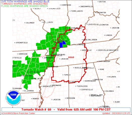
9:34 - Since it is not coming up on the radar imagery yet, here is just the warning/watch map. Red is tornado warning, that shade of orange in NW AL is the block of severe thunderstorm warnings.
Yellow is tornado watch, which is covered up by the other brownish shade of orange for much of North AL, the High Wind Warning.
9:39 - Thanks to NWS Birmingham for a decent radar image.
9:44 - Funnel cloud reported in Alcorn County, MS.
9:55 - The tornado warning in Mississippi was let go. But the severe thunderstorm warning in Northwest Alabama (Shoals included) carries a tag that a tornado is possible in the storm, even though the main threat is damaging straight-line winds.
10:08 AM - Two people were injured back in Mooresville MS from this line when a tree fell on a house, said they were unable to evacuate premises.
10:19 - Unfortunately just got a note from SPC that as we continue to get breaks in the clouds and warm up, unstable air will increase the tornado threat as storms move East and we get into the afternoon.
10:21: Many trees down west of Hamilton in Marion County. These storms today mean business.
10:30 - The line moves along. More warnings are coming out . . .
SEL0
URGENT - IMMEDIATE BROADCAST REQUESTED
Tornado Watch Number 60
NWS Storm Prediction Center Norman OK
625 AM CST Fri Mar 3 2023
The NWS Storm Prediction Center has issued a
* Tornado Watch for portions of
Northwest Alabama
Far southeast Illinois
Western into central Kentucky
Northeast Mississippi
Western into Middle Tennessee
* Effective this Friday morning and afternoon from 625 AM until
100 PM CST.
* Primary threats include...
A few tornadoes and a couple intense tornadoes possible
Scattered damaging winds likely with isolated significant gusts
to 80 mph possible
SUMMARY...A fast moving line of storms will intensify and track
northeast this morning into early afternoon. Damaging gusts and a
few tornadoes will be the primary hazards with these storms.
The tornado watch area is approximately along and 85 statute miles
east and west of a line from 10 miles west northwest of Owensboro KY
to 40 miles south southeast of Tupelo MS. For a complete depiction
of the watch see the associated watch outline update (WOUS64 KWNS
WOU0).
PRECAUTIONARY/PREPAREDNESS ACTIONS...
REMEMBER...A Tornado Watch means conditions are favorable for
tornadoes and severe thunderstorms in and close to the watch
area. Persons in these areas should be on the lookout for
threatening weather conditions and listen for later statements
and possible warnings.
&&
OTHER WATCH INFORMATION...CONTINUE...WW 59...
AVIATION...Tornadoes and a few severe thunderstorms with hail
surface and aloft to 1 inch. Extreme turbulence and surface wind
gusts to 70 knots. A few cumulonimbi with maximum tops to 400. Mean
storm motion vector 22050.
...Leitman/Edwards
WOUS64 KWNS 031222
WOU0
BULLETIN - IMMEDIATE BROADCAST REQUESTED
TORNADO WATCH OUTLINE UPDATE FOR WT 60
NWS STORM PREDICTION CENTER NORMAN OK
625 AM CST FRI MAR 3 2023
TORNADO WATCH 60 IS IN EFFECT UNTIL 100 PM CST FOR THE
FOLLOWING LOCATIONS
ALC033-043-057-059-075-077-079-083-089-093-103-127-133-031900-
/O.NEW.KWNS.TO.A.0060.230303T1225Z-230303T1900Z/
AL
. ALABAMA COUNTIES INCLUDED ARE
COLBERT CULLMAN FAYETTE
FRANKLIN LAMAR LAUDERDALE
LAWRENCE LIMESTONE MADISON
MARION MORGAN WALKER
WINSTON
ILC069-127-151-031900-
/O.NEW.KWNS.TO.A.0060.230303T1225Z-230303T1900Z/
IL
. ILLINOIS COUNTIES INCLUDED ARE
HARDIN MASSAC POPE
KYC027-031-033-035-039-047-055-059-061-075-083-085-091-101-105-
107-139-141-143-145-149-157-163-177-183-213-219-221-225-227-233-
031900-
/O.NEW.KWNS.TO.A.0060.230303T1225Z-230303T1900Z/
KY
. KENTUCKY COUNTIES INCLUDED ARE
BRECKINRIDGE BUTLER CALDWELL
CALLOWAY CARLISLE CHRISTIAN
CRITTENDEN DAVIESS EDMONSON
FULTON GRAVES GRAYSON
HANCOCK HENDERSON HICKMAN
HOPKINS LIVINGSTON LOGAN
LYON MARSHALL MCCRACKEN
MCLEAN MEADE MUHLENBERG
OHIO SIMPSON TODD
TRIGG UNION WARREN
WEBSTER
MSC003-009-013-017-057-071-081-093-095-115-117-139-141-145-161-
031900-
/O.NEW.KWNS.TO.A.0060.230303T1225Z-230303T1900Z/
MS
. MISSISSIPPI COUNTIES INCLUDED ARE
ALCORN BENTON CALHOUN
CHICKASAW ITAWAMBA LAFAYETTE
LEE MARSHALL MONROE
PONTOTOC PRENTISS TIPPAH
TISHOMINGO UNION YALOBUSHA
TNC003-005-017-021-023-033-037-039-043-045-047-053-055-069-071-
075-077-079-081-083-085-099-101-103-109-113-117-119-125-131-135-
147-149-161-165-181-183-187-189-031900-
/O.NEW.KWNS.TO.A.0060.230303T1225Z-230303T1900Z/
TN
. TENNESSEE COUNTIES INCLUDED ARE
BEDFORD BENTON CARROLL
CHEATHAM CHESTER CROCKETT
DAVIDSON DECATUR DICKSON
DYER FAYETTE GIBSON
GILES HARDEMAN HARDIN
HAYWOOD HENDERSON HENRY
HICKMAN HOUSTON HUMPHREYS
LAWRENCE LEWIS LINCOLN
MADISON MARSHALL MAURY
MCNAIRY MONTGOMERY OBION
PERRY ROBERTSON RUTHERFORD
STEWART SUMNER WAYNE
WEAKLEY WILLIAMSON WILSON
ATTN...WFO...HUN...OHX...MEG...PAH...LMK...BMX...
Here we go . . . details soon.
Coming soon . . .
Mesoscale Discussion 0242
NWS Storm Prediction Center Norman OK
0401 AM CST Fri Mar 03 2023
Areas affected...portions of northern MS/AL...western into Middle
TN...western KY...far southeast MO...and far southern IL
Concerning...Severe potential...Watch likely
Valid 031001Z - 031230Z
Probability of Watch Issuance...80 percent
SUMMARY...A new tornado watch will likely be needed by 13-14z/7-8 am
CST across portions of the Tennessee and Lower Ohio Valleys.
Damaging gusts and a few tornadoes will be possible through
midday/early afternoon.
DISCUSSION...A quasi-stationary boundary is evident in surface
analysis extending from west-central TN toward the TN/KY border
vicinity north of Nashville. Meanwhile, the warm front, demarcating
mid-60s F surface dewpoints from upper 50s to low 60s F dewpoints,
is arcing from near Memphis into east-central MS (between Starkville
and Tupelo) and central AL. Large-scale ascent ejecting into east
TX, as the mid/upper trough becomes more negatively tilted as of
10z, will aid in deepening of the surface low over central AR as it
tracks northeast toward the Lower OH Valley through midday. As this
occurs, the warm front will lift northward, allowing for
destabilization of the airmass downstream from WW 59 across parts of
northern MS into western and Middle TN, and eventually northward
toward the lower OH River.
Ongoing precipitation across parts of western/Middle TN/southeast
MO/western KY and vicinity lends to some uncertainty with respect to
the northern extent of severe potential through the morning, and
possible watch issuance. While a relative minimum in severe activity
may exist in the short term, as the warm front surges northward
through mid-morning, forecast soundings in addition to CAMs and
deterministic guidance suggest organized convection will develop
northeast from near the MS River through western KY.
Where the more moist and unstable airmass evolves, sufficient
low-level instability, in the presence of intense low-level shear
(aided by a 50-60 kt 850 mb jet), will support organized linear
convection with perhaps embedded or semi-discrete cells. Damaging
gusts and a few tornadoes will be possible with this activity
through midday/early afternoon. A downstream watch will likely be
needed by around 13z-14z.
..Leitman/Edwards.. 03/03/2023
...Please see www.spc.noaa.gov for graphic product...
ATTN...WFO...LMK...OHX...BMX...HUN...PAH...MEG...JAN...
LAT...LON 36008974 36938956 37368926 37688873 37868807 37918734
37868678 37748655 37208638 36328636 35068661 34518683
34178714 33848781 33598840 33638940 33788978 34038992
36008974


.gif)
.png)


.png)


No comments:
Post a Comment