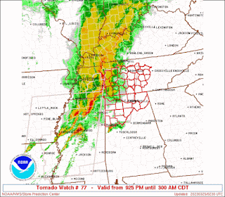
9:27 PM - And here we are. Details soon.
Going to post updates here as needed and as possible. Will make new posts as needed for tornado warnings also. But for now, updates will appear below in this post.
9:39 PM - A confirmed tornado that has done a lot of damage, a supercell storm, could affect counties like Marion and Lamar in Alabama by about 11 PM if it stays on current track and hangs together. And it probably will hang together for a long time. Major thanks to NWS Birmingham for giving us a lot of advance notice to watch this one particular storm.
9:54 - Got two tornadoes back in MS getting uncomfortably close to the AL state line. Folks in western counties near state line, in Northwest and West Central Alabama, need to be getting ready to take shelter if a warning is required soon for you. I would go ahead and shelter before the storms get too close, as soon as the warning comes out and you know the storm is headed in your general direction.
Get into a small central room on the lowest floor (basement if you have one) of a sturdy house or other strong building, and cover your body, esp head, in case of falling or flying debris.
One of these storms, the southern one, has produced devastation across Mississippi earlier tonight.
9:58 - And now a tornado warning up to the state line.
10:09 PM - Note from SPC that supercells are a good possibility like the one getting ready to move into NW AL, even if cells are embedded in line. Some may do more than average tornado damage. That potential is there, be aware of it.
10:13 - Got a severe thunderstorm warning for Colbert, Franklin, and Lauderdale Counties, so up around the Shoals, with a note that a tornado is possible within the storm, greater threat is thought to be damaging winds. But there is a low risk for a tornado in this storm too.
SEL7
URGENT - IMMEDIATE BROADCAST REQUESTED
Tornado Watch Number 77
NWS Storm Prediction Center Norman OK
925 PM CDT Fri Mar 24 2023
The NWS Storm Prediction Center has issued a
* Tornado Watch for portions of
Northern Alabama
Middle Tennessee
* Effective this Friday night and Saturday morning from 925 PM
until 300 AM CDT.
* Primary threats include...
A few tornadoes likely with a couple intense tornadoes possible
Scattered damaging winds likely with isolated significant gusts
to 75 mph possible
Isolated large hail events to 1 inch in diameter possible
SUMMARY...A bowing squall line will continue eastward from northeast
Mississippi and western Tennessee into middle Tennessee and
northwestern Alabama through the early overnight hours. The squall
line will pose a threat for embedded tornadoes and swaths of
damaging winds up to 75 mph. Farther south, a supercell or two may
persist into Alabama ahead of the squall line, with the potential to
produce a strong tornado or two.
The tornado watch area is approximately along and 55 statute miles
east and west of a line from 15 miles northwest of Nashville TN to
40 miles east of Columbus MS. For a complete depiction of the watch
see the associated watch outline update (WOUS64 KWNS WOU7).
PRECAUTIONARY/PREPAREDNESS ACTIONS...
REMEMBER...A Tornado Watch means conditions are favorable for
tornadoes and severe thunderstorms in and close to the watch
area. Persons in these areas should be on the lookout for
threatening weather conditions and listen for later statements
and possible warnings.
&&
OTHER WATCH INFORMATION...CONTINUE...WW 76...
AVIATION...Tornadoes and a few severe thunderstorms with hail
surface and aloft to 1 inch. Extreme turbulence and surface wind
gusts to 65 knots. A few cumulonimbi with maximum tops to 450. Mean
storm motion vector 25050.
...Thompson
Details soon when it is issued. A tornado outbreak is ongoing back in Mississippi, with a confirmed tornado that has caused some real destruction and some injuries, western part of Mississippi.
9:10 PM - In the meantime here is a radar check. The southernmost storm is the confirmed tornado that has caused very significant damage and some injuries. Chasers there are trying to help with relief efforts there.
Mesoscale Discussion 0331
NWS Storm Prediction Center Norman OK
0907 PM CDT Fri Mar 24 2023
Areas affected...Parts of northwestern AL into Middle TN
Concerning...Severe potential...Watch likely
Valid 250207Z - 250330Z
Probability of Watch Issuance...95 percent
SUMMARY...The risk of severe storms capable of all hazards will
increase over portions of northwestern AL into Middle TN during the
next few hours. A watch issuance is likely before 0230Z.
DISCUSSION...A QLCS is tracking eastward across western TN into
northern MS, while northeastward-moving supercells are ongoing over
northern into central MS. As a large-scale trough evident in water
vapor imagery continues eastward this evening, the warm sector
(characterized by middle/upper 60s dewpoints) will spread eastward
into parts of western AL and Middle TN. At the same time, a
strengthening low-level jet will also shift eastward over the warm
sector, favoring a continuation of the severe storms with eastward
extent. Large/clockwise-turning hodographs (sampled by regional VWP)
will support organized storms including supercells (even if embedded
in a line) with a risk of tornadoes, damaging winds, and large hail.
A watch will likely be issued for parts of this area before 0230Z.
..Weinman/Thompson.. 03/25/2023
...Please see www.spc.noaa.gov for graphic product...
ATTN...WFO...OHX...BMX...HUN...MEG...JAN...
LAT...LON 33258829 34048822 34568815 35168797 35398767 35408714
35268643 34888600 34468602 33848685 33118732 32838768
32928829 33258829


No comments:
Post a Comment