


The basic ideas are the same, but some shifts have happened in the thinking. The area that includes the best risk of more-than-average tornado damage later tonight now includes far Northwest Alabama, places like Florence or Waynesboro up in Tennessee. Just as a rule of thumb though, I'd say it might be a mistake to assume that just because a tornado happens in a squall line, it will always be weak. There have been many QLCS tornadoes over the years that have done more than just the minimal damage. And even in California, where tornadoes are rare, there was some decent damage done by that thing the other day near Los Angeles. I'm for taking any tornado warning seriously, especially at night when they are so hard to confirm anyway.
Remember that we all have a basic risk for severe thunderstorms, some of which could produce tornadoes, tonight into early Saturday morning (at least into the dark hours of the morning) in North Alabama and Southern Middle Tennessee. That risk may be a little enhanced the further you get into Northwest Alabama.
But the important thing is that everyone has a reliable way to get warnings.
Not an outdoor siren.
But a weather radio.
Or at least WEA enabled on a cell phone that is in a mode to wake them up.
Maybe a service like WeatherCall is an investment to think about.
Or even a good radio station that cuts in for severe weather, if you like to go to sleep listening to music. Radio is more likely to wake someone up than TV.
But it's important to be able to get the warning tonight, and to be able to wake up and get to shelter within about five minutes of getting that warning - the sooner the better.
I'd advise taking severe thunderstorm warnings seriously in this event too. Sort of wish people would always do that, but I've found over the years, that is a losing battle. So when it seems extra important, I'll mention it. This is a situation where a tornado could develop very quickly from a severe thunderstorm, before the warning gets upgraded. I could see that happening easily.
People who have to drive need to plan some sort of public building that will be open so they can pull over and get to shelter if need be.
People in mobile homes have to have a plan to get out of there and into a more substantial shelter, a house or other strong building that is anchored down to the ground. Even if that means going to the nearest public shelter. That takes some planning, and making a move before the storms get too close.
In a regular house or other sturdy building, the basic idea is to get as low down in the structure as you can, and as near the center as you can, putting as many walls between you and the storm outside as possible.
Staying well away from any windows.
Trying for a small space, like a bathroom, closet, or hallway. Since those walls are less likely to fail under pressure of the winds of a tornado.
And ideally covering your body in some way, at least covering your head. Whether that means getting up under something sturdy like a table or set of stairs, in case of falling debris. Or if it means grabbing a pillow or some blankets in case of flying debris. Or if you have a safety helmet for playing football or for a bike. Which provides excellent protection from flying debris.
This should start late tonight, probably close to midnight, and may last until close to daybreak Saturday. But it would be wise to monitor the trends before going to bed tonight, if you're going to bed about 9 or 10 tonight. See how the line of storms is taking shape and moving along. If the timing were to speed up and we've got a squall line moving into Northwest Alabama by about 10 PM, then the rest of us may have to deal with that line sooner too. The outlines of threat levels and timing are usually pretty good estimates, but they are still estimates. Storms can always throw you a curve.
Definitely let the people you love know about this threat, because even though it's not as full-blown as what is expected this afternoon/evening in Mississippi, it is still an overnight threat for severe weather. Nobody is going to care much what EF-scale rating a tornado had if somebody ends up getting seriously hurt by being unaware and not taking any precautions. The point will be, somebody got hurt. So all the nitpicking is not what counts. Any tornado is dangerous. Damaging thunderstorm winds in a squall line can also be dangerous when the storm does not end up producing a tornado. So let's respect the threat and do the right things if and when we have to.
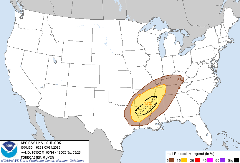
SPC AC 241626
Day 1 Convective Outlook
NWS Storm Prediction Center Norman OK
1126 AM CDT Fri Mar 24 2023
Valid 241630Z - 251200Z
...THERE IS A MODERATE RISK OF SEVERE THUNDERSTORMS ACROSS PARTS OF
ARKANSAS/LOUISIANA/MISSISSIPPI AND SOUTHWEST TENNESSEE...
...SUMMARY...
A severe weather outbreak is possible across the Lower Mississippi
Valley and Mid-South this afternoon and tonight. The most likely
time period for strong tornadoes is between 5 pm and Midnight CDT.
...Lower Mississippi Valley/Mid-South/Tennessee Valley...
Upper-air analysis and more contemporary water vapor imagery
features a relatively low amplitude shortwave trough centered near
the New Mexico/Mexico/west Texas border vicinity, with a preceding
broad belt of strong mid/high-level southwesterlies extending across
the southern plains toward the Midwest. These westerlies are
partially atop a convectively augmented front that extends from
central/northeast Texas into the Ozarks, and then largely parallels
the Lower Ohio River (but to the south). Within the warm sector, 12z
upper-air analysis did feature a relative minimum of higher-caliber
source-region moisture as noted in 850mb analysis (supplemented by
GPS PW values) across parts of south-central/east Texas into
southern Louisiana, although higher moisture content was noted
across the ArkLaTex/Mid-South.
Scattered thunderstorms are ongoing along the effective frontal zone
from the ArkLatex into central/eastern Arkansas, and northeastward
into western Tennessee and eastern Kentucky. Latest thinking is that
initial development/intensification of surface-based storms should
occur across northeast/east Texas, possibly far southeast Oklahoma,
into western Arkansas in vicinity of the front/abating outflow and
surface low vicinity.
This severe threat should expand/organize east-northeastward as the
surface cyclone steadily deepens and tracks northeast along the
baroclinic zone through tonight. After some initial-discrete
storms/supercells, it seems like that an intensifying QLCS will
evolve across Arkansas and spread toward the Tennessee Valley
through the evening. Strengthening low-level winds and enlarging
hodographs should compensate for the northern gradient of the
surface-based instability plume. This QLCS will likely contain
embedded supercell and mesovortex structures supportive of tornadoes
(including potential for a few EF2s) and significant damaging wind
swaths (up to around 80-90 mph).
Farther south, increasing low-level moisture across the Sabine
Valley towards the ArkLaMiss should eventually yield a plume of
moderate MLCAPE around 1500 J/kg by evening. This warm theta-e
advection regime should also foster some discrete supercellular
convection ahead and south/southeast of the QLCS towards late
afternoon into early evening within the resultant MLCAPE gradient.
Deep-layer shear profiles will support supercells, a few of which
could become long-tracked across the ArkLaMiss region. Low-level
hodographs, while not quite as enlarged as compared to farther
north, will support a threat for strong tornadoes (EF2+) through
much of the evening, until warm sector winds becomes increasingly
veered from southwest to northeast overnight.
..Guyer/Moore.. 03/24/2023


No comments:
Post a Comment