Tuesday (High 82, Low 65): Partly cloudy. Scattered showers and thunderstorms are possible.
Wednesday (High 79, Low 66): Mostly cloudy. Numerous rounds of showers and thunderstorms are possible.
Thursday (High 81, Low 66): Partly cloudy. Scattered showers and thunderstorms are possible.
Friday (High 84, Low 64): Partly cloudy with a 30% chance of showers/thunderstorms.
Saturday (High 87, Low 65): Partly cloudy with a 20% chance of showers/thunderstorms.
Sunday (High 90, Low 68): Partly cloudy with a 20% chance of showers/thunderstorms.
Monday (High 88, Low 68): Partly cloudy with a 30% chance of showers/thunderstorms.
Tuesday (High 89, Low 70): Partly cloudy with a 20% chance of showers/thunderstorms.
Wednesday (High 90, Low 70): Partly cloudy with a 20% chance of showers/thunderstorms.
Thursday (High 91, Low 70): Partly cloudy with a 20% chance of showers/thunderstorms.
Skies were variably cloudy today in the Tennessee Valley. Overall I'd say we saw more clouds than sun, though many of us saw a good bit of sunshine, especially later in the day. Winds were variable as well, starting the day from the South and shifting more West in the afternoon and even to the North/Northwest in some places. It got breezy at times this afternoon. The High in Cullman was 82, and the Low this morning was 72. Jasper saw a High of 86 after a morning Low of 70. Quite a bit of fog there this morning after the rain and storms moved out, also noticeably breezy at many points this afternoon. Winds tended to be lighter today in Haleyville, where they had a lot of cloud cover through much of the day, High of 82, Low of 70.
Along and ahead of this cold front, the weather pattern remains active. They are having some
significant flash flooding down at Mobile and other parts of the Gulf Coast.
The cutoff Low in the Ohio Valley will become the next main focus for our weather as we go further into this week. It does not look like that pesky front will give us any more trouble in North Alabama or into Tennessee.
Tomorrow starts the tale of the meandering Low.
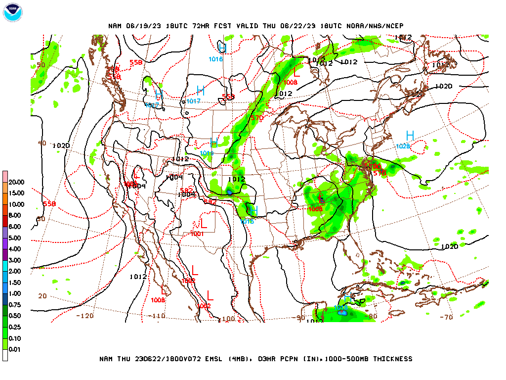
The NAM shows less moisture here than the GFS as the front pushes into Georgia and the Low kind of floats around here and there on the map.
For the temperature tomorrow I'll go with a persistence forecast, 82 degrees, Low near 65. Rain chances are a little challenging in this anomalous pattern as we start to come out of it. But the coverage of rain was not all that great today in the region. And I don't think it will be tomorrow. Will go on the lower end of guidance with a 40% chance of rain tomorrow. The Storm Prediction Center is not outlooking us for any more severe weather any time soon, and we'll take the break from that. These look like the usual early summer showers and thunderstorms. There is not even a lot of heat to work with for the pulse-type strong storms.
The position of this Low on Wednesday should bring us an increase in rain chances if the GFS is right.
The NAM supports the idea, so we have a 50% chance of rain for Wednesday, High near 80, might dip into upper 70's, Low in mid-to-upper-60's.
The GFS suggests moisture levels dropping slightly again on Thursday.
The NAM is iffy by 72 hours out, but it definitely supports that idea.
The ECMWF has a much wetter look, and taking it into account, might keep rain chance at 50% for Thursday. Close call. But we'll do a rain chance of 40-50% here, once again a High near 80, Low in mid-60's.
On Friday that Low should lift back up into the Ohio River Valley and start to open up into a trough. While ridging of High pressure starts to build out over the Plains. Going to go ahead and take our rain chance down to 30% here and forecast a High in lower 80's, Low in lower 60's.
That pattern amplifies on Saturday, and I think all we need is a 20% chance of rain by then, High getting back up into at least the mid-80's but perhaps upper 80's, the Low in the lower-to-mid-60's.
And that pattern looks to hold for Sunday. May actually see a High near 90, Low in upper 60's. Might take out rain chance if only going by model guidance, but it's a close enough call especially given the time of year, the climatology, to keep a 20% chance of rain in there.
Might actually bump rain chance back up to 30% for Monday as a weak boundary comes through here in the Northwest upper-level wind flow. Should see a High in upper 80's, Low in upper 60's.
Then if we want to look into the land of tea leaves reading, Tuesday looks most likely a dry day for a change, so a High near 90, Low getting up close to 70 from Monday's moisture. Looking at both GFS/ECWMF, probably just decrease rain chance to 20% for Tuesday, then maybe take rain chance completely out for Wednesday, High of 90 or so, Low near 70 or upper 60's. Then Thursday just looks hot and dry, Lower 90's for the High, near 70 for the Low. But I'm not sure if I'll include the "tea leaves" in this forecast. It's really stretching what the science can do, even with great computer models. But I've noticed more TV stations doing this than I was aware. I went looking around last night when things got slow but there was still a severe weather threat. And quite a few of them do this, even stations with great meteorologists. So I may jump on board more often in the summertime, since the weather is (usually - not here lately) pretty low-impact anyway, mistakes don't matter all that much.
I skimmed a few of these 10-day outlooks, and it looks like they are just bluffing their way through it and deferring to climatology anyway. Since this is not a paying gig (and I do have a paying gig now, though it is part-time, starting out), I guess I'll put in a 10-day outlook above, just because it is summer time and because if I don't post anything in a while, people still have something to look at that might be better than the Farmer's Almanac.
That western of the two tropical disturbances became a tropical depression, the third of this season (rather early in the season) today and then quickly became
Tropical Storm Bret. So I'm going out back to take a look at my weather rock for old-fashioned guidance (similar to tea leaf guidance?). Okay, back now, weather rock says that this may be an unusually active tropical season due to warmer waters. And it may start kind of early.
That other disturbance a few hundred miles South/Southwest of the Cabo Verde Islands is looking like it may develop into a tropical cyclone within the next couple days or so. All joking aside, we usually do not see this until July or August.
The most likely track of Tropical Storm Bret takes it to the Lesser Antilles by Thursday or Friday at hurricane strength. Then as it gets more toward Puerto Rico, the U.S. Virgin Islands, and the Dominican Republic, it may weaken back to tropical storm strength because of an upper-level trough with a lot drier air. Still, if you are in or near these areas, keeping a close eye on this storm would be wise. Its development and strengthening have been rapid, and while there is no reason to be overly alarmed by this, there is good reason to keep watching and see what it does, also keep up with the latest forecasts.

And you can look at the spread in the tropical models, but the National Hurricane Center forecast basically tells you all you need to know. If you catch someone on TV or the Net claiming to have some kind of insider special knowledge that you can't see or read from the NHC, that's about 99.9% likely to just be somebody yanking your chain. I did not show the intensity guidance here, but it is also well in line with the NHC forecast. Everybody in the Lesser Antilles, the Virgin Islands, and Puerto Rico need to be ready to take your hurricane precautions. It may affect some of those areas as early as this Thursday. Everybody else, I'd just keep an eye on it to be on the safe side, since even a slight change in parameters over a few days can drastically change a hurricane or tropical storm forecast.

Around these parts, we may see about another inch of rain over the next seven days, maybe closer to two inches in Northeast Alabama into Southern Middle Tennessee. Of course, as we get into more of a typical summer setup of just isolated or scattered rain, it won't be this cut-and-dried. But this map shows the best estimate anyway. Only showing it because we've had an unusual amount of rain lately, and people might want to have an idea of what more to expect. Fortunately we have not had flooding issues around here lately.
That storm in Owens Cross Roads last night sounded awful. I'll check out what the storm survey turns up. Someone I know from up there said he was told that entire buildings were destroyed. If that is so, guessing they were weaker structures. But we did have golfball-sized hail or maybe even baseball-sized reported there.
Here is the latest from the National Weather Service in Huntsville. They are carefully assessing the damage. It looks like this was a severe thunderstorm that did significant damage, including structural damage, because of very large hail blowing around in winds of at least 60 miles per hour. So far there are no signs of it having produced a tornado.
Other than that one terrible storm (that started around Vinemont, best I remember from radar, intensified as it moved through Morgan County), we got pretty easy around here. While there were half a dozen tornado reports in Mississippi, and one in the Florida Peninsula, also a random one way up in Oregon.
It could have been a lot worse last night, and even in Owens Cross Roads, I have not heard of any injuries. We had a bizarre start to this summer.
Anyway in case I'm not on here for a while, keep an eye on the tropics, as they look like plenty of fun starting early this year.


.gif)


No comments:
Post a Comment